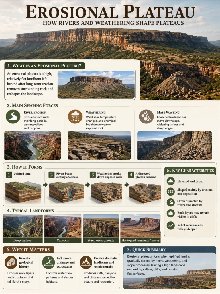
Erosional Plateau: How Rivers and Weathering Shape Plateaus
Landform Process An erosional plateau is a raised land surface shaped less by fresh lava or...
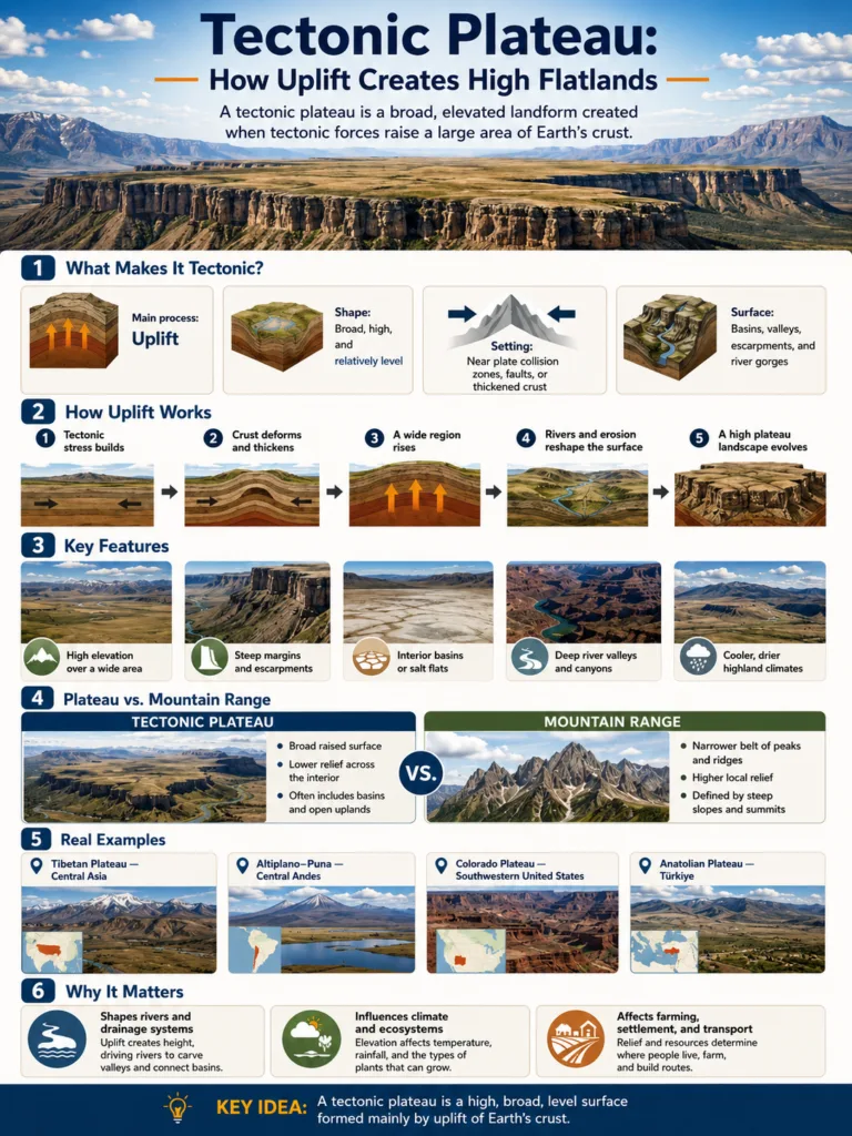
Tectonic Plateau: How Uplift Creates High Flatlands
Landform Type A tectonic plateau is a broad, raised highland formed when Earth movements lift large...
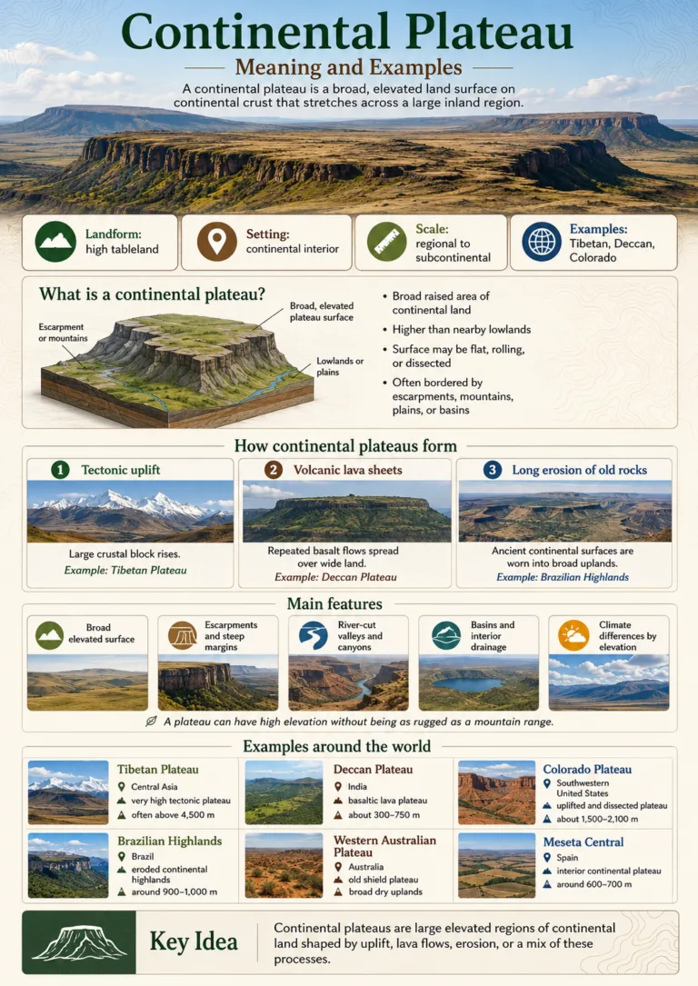
Continental Plateau: Meaning and Examples
Plateau Type A continental plateau is a broad, raised land surface that sits on continental crust...
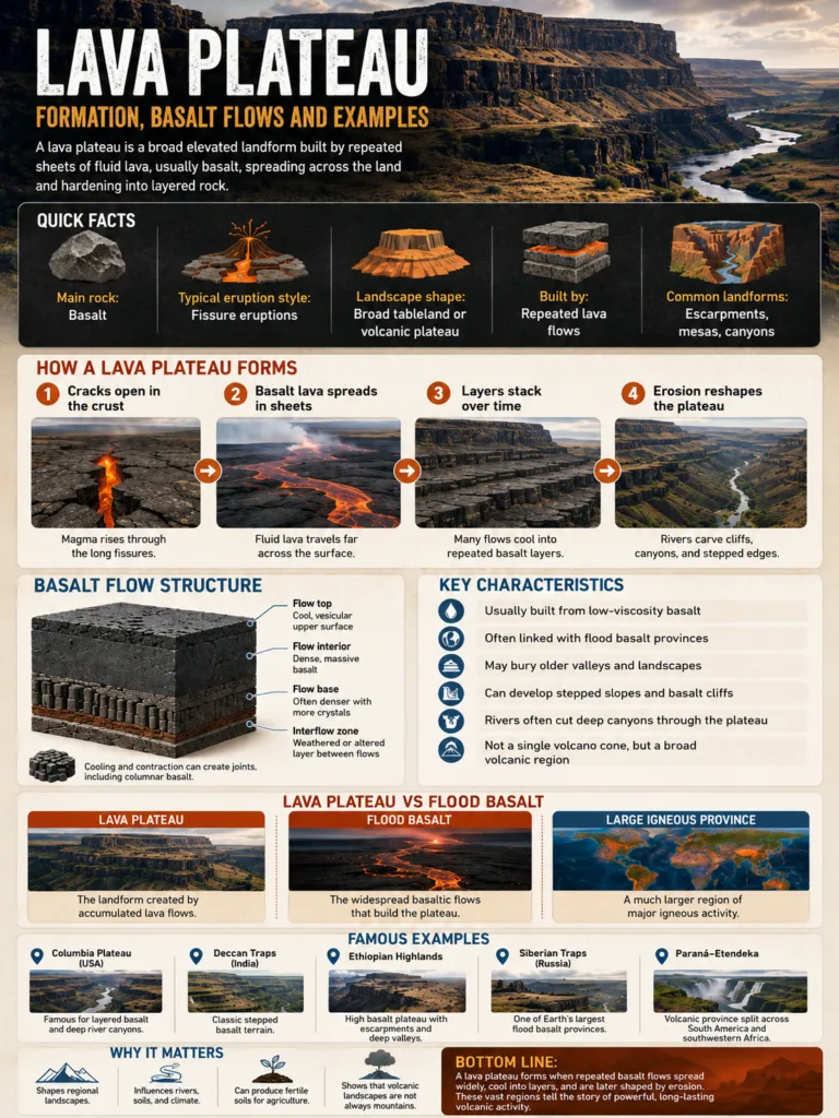
Lava Plateau: Formation, Basalt Flows and Examples
Volcanic Plateau Landform A lava plateau is a broad, raised landform built by repeated sheets of...
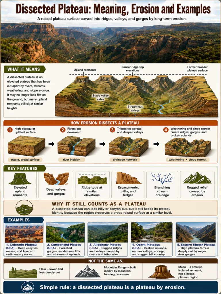
Dissected Plateau: Meaning, Erosion and Examples
Plateau Type • Erosion • Landform Reading A dissected plateau is an elevated land surface that...
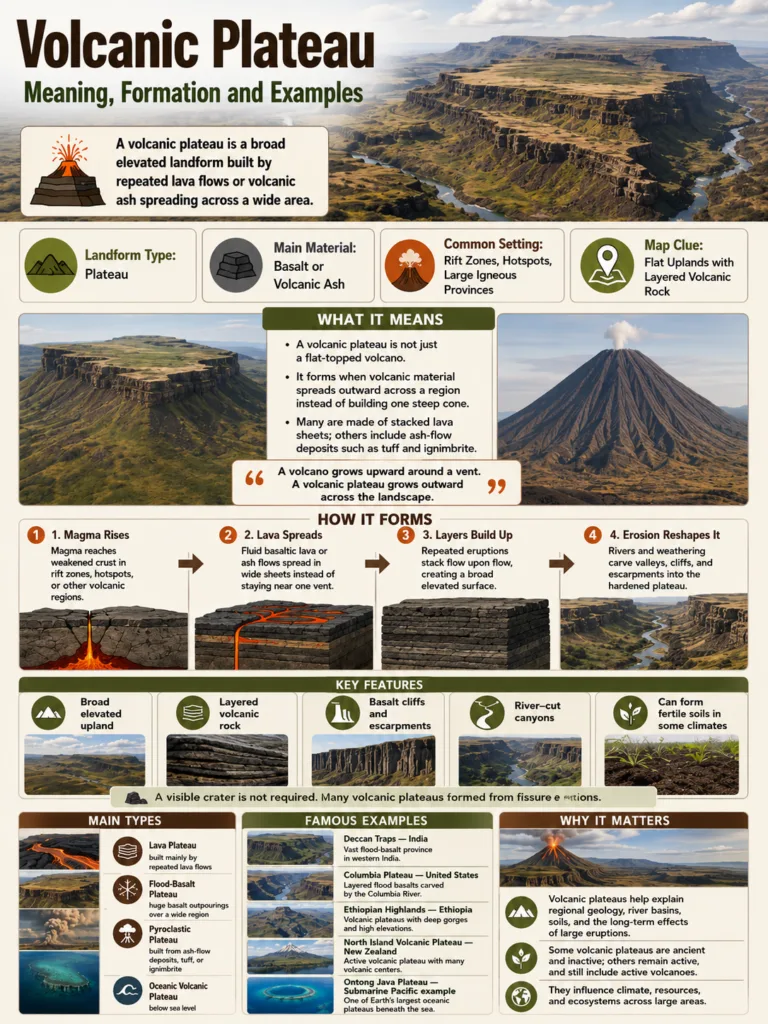
Volcanic Plateau: Meaning, Formation and Examples
Volcanic Plateau Landform A volcanic plateau is a broad, elevated landform built by repeated volcanic eruptions,...
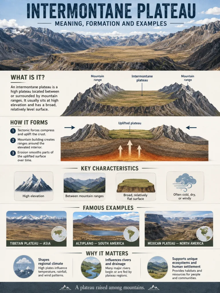
Intermontane Plateau: Meaning, Formation and Examples
Plateau Type An intermontane plateau is a high, broad tableland that sits between mountain ranges. It...
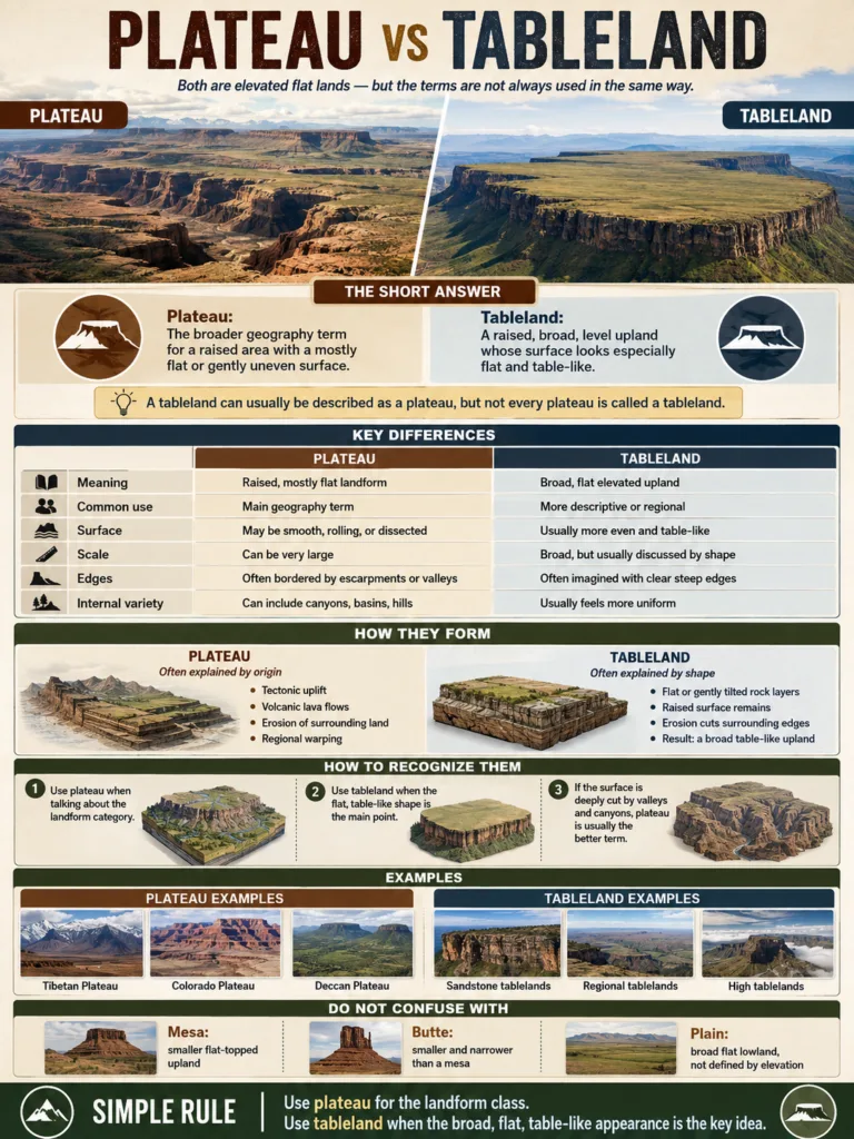
Plateau vs Tableland
Landform Comparison A plateau and a tableland both describe raised, mostly level ground, but they are...
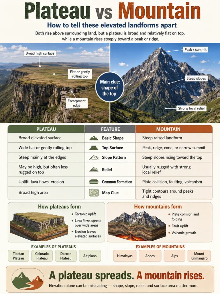
Plateau vs Mountain
Landform Comparison A plateau and a mountain can both rise high above nearby land, but they...
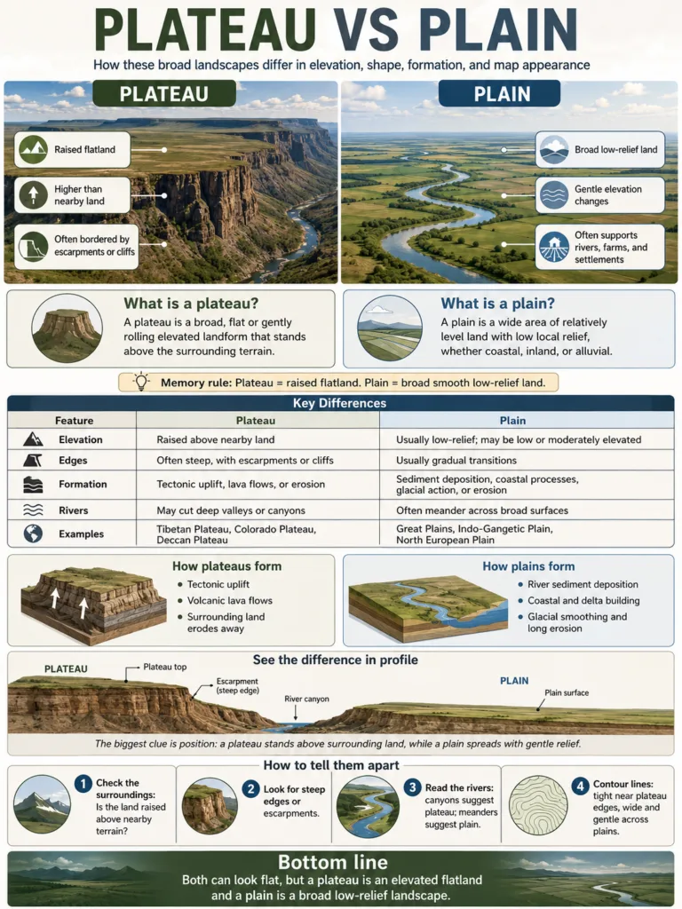
Plateau vs Plain
Landform Comparison A plateau and a plain can both look wide and fairly flat, but they...
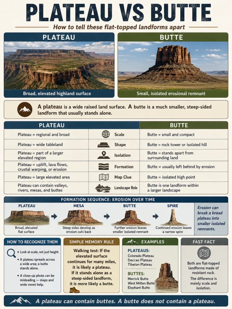
Plateau vs Butte
Landform Comparison A plateau is a broad, elevated flatland; a butte is a smaller, isolated rock...
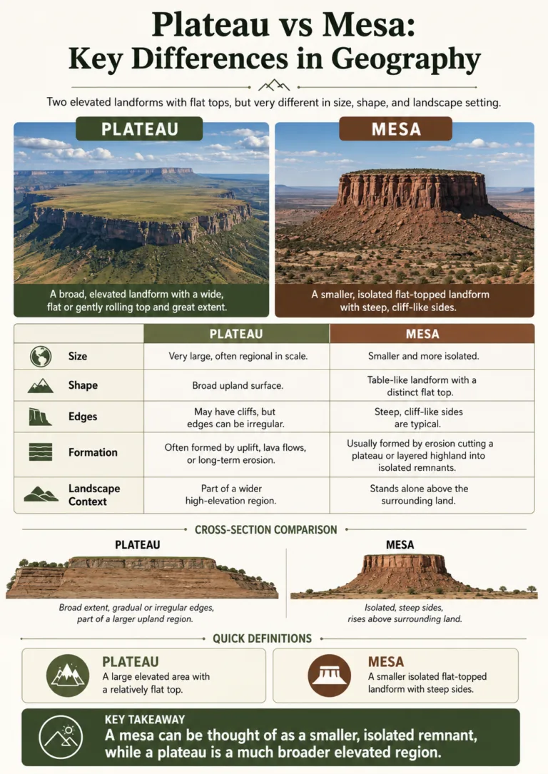
Plateau vs Mesa: Key Differences in Geography
A plateau is a broad, raised area of land with a relatively flat surface. A mesa...
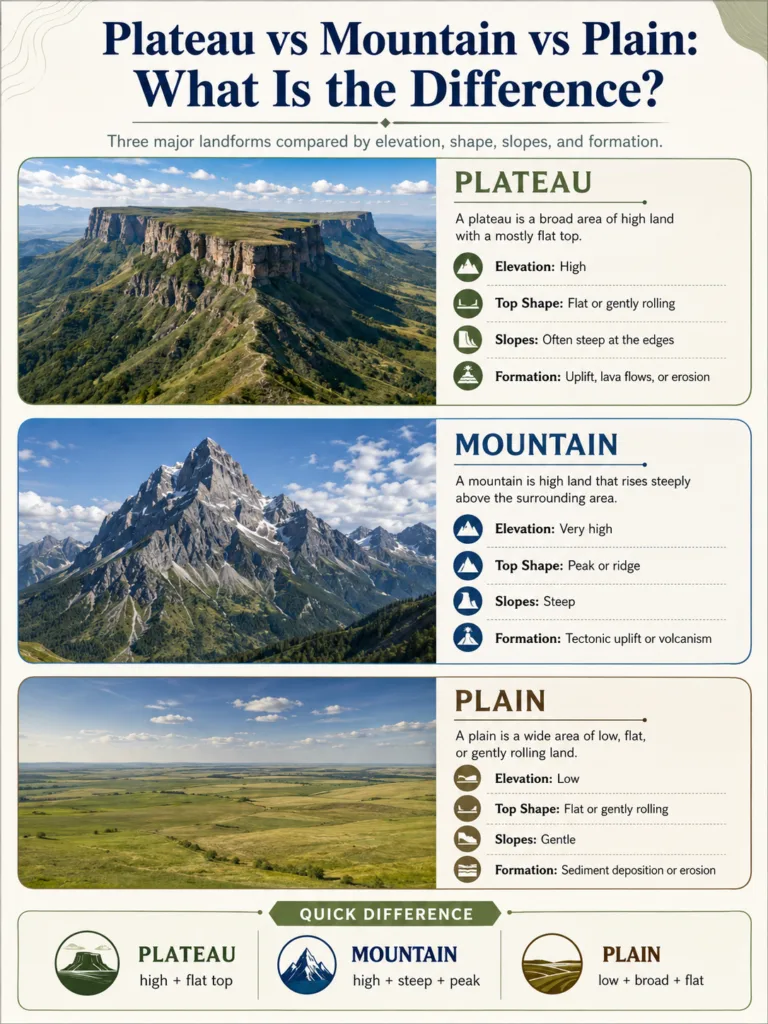
Plateau vs Mountain vs Plain: What Is the Difference?
A plateau, a mountain, and a plain can all cover large areas of land, but they...
13 articles in Types Of Plateaus
Plateaus are raised landforms with broad, fairly level surfaces. They can form from tectonic uplift, repeated lava flows, crustal heating, long erosion, or a mix of these processes. The main types of plateaus include volcanic plateaus, dissected plateaus, intermontane plateaus, piedmont plateaus, continental plateaus, and erosional tablelands.
A plateau type is not always a clean label. One plateau may be volcanic in origin, dissected by rivers, and located between mountain ranges. That is why geographers often classify plateaus in two ways: how they formed and where they sit on the map.
| Plateau Type | Main Formation Process | Typical Features | Map Clue | Examples |
|---|---|---|---|---|
| Volcanic Plateau | Repeated lava flows or volcanic ash build a broad raised surface. | Basalt layers, dark volcanic rock, gentle surface, river-cut canyons. | Wide lava fields, old fissure zones, trap landscapes. | Deccan Plateau, Columbia Plateau, Ethiopian Plateau. |
| Dissected Plateau | Uplift raises land, then rivers and weathering cut it into valleys and canyons. | Mesas, buttes, gorges, escarpments, high ridges with similar summit levels. | Flat-topped remnants separated by deep river valleys. | Colorado Plateau, Ozark Plateau, parts of the Ethiopian Highlands. |
| Intermontane Plateau | Crust is squeezed and lifted inside or between mountain belts. | Very high elevation, basins, dry interiors, mountain rims. | Plateau surface enclosed by major ranges. | Tibetan Plateau, Altiplano, Iranian Plateau. |
| Piedmont Plateau | Uplifted or eroded land sits at the foot of mountains. | Gentle slope from mountains toward plains or lowlands. | One side faces mountains; the other opens toward lower country. | Piedmont areas near the Appalachians, parts of Malwa Plateau. |
| Continental Plateau | Broad inland uplift, old rock surfaces, or long erosion create a wide tableland. | Large upland region, often far from young mountain belts. | Wide interior highland surrounded by lower plains or basins. | Central Siberian Plateau, Arabian Plateau, Western Plateau of Australia. |
| Erosional or Denudation Plateau | Long weathering removes softer rocks and leaves resistant high surfaces. | Old hard rock, stepped slopes, residual hills, tablelands. | Plateau-like surfaces left after long stripping of rock and soil. | Chota Nagpur Plateau, parts of the Appalachian Plateau, local tablelands. |
| Oceanic Plateau | Large submarine volcanic outpourings build raised areas on the seafloor. | Underwater highland, igneous rock, broad seafloor rise. | Shown on bathymetric maps, not normal land maps. | Ontong Java Plateau, Kerguelen Plateau. |
Landform Note: A plateau is a highland surface, not just a flat plain. The height above nearby land, the edge slope, and the broad top surface matter more than perfect flatness.
What Makes a Landform a Plateau?
A plateau is usually defined by three traits: it stands higher than nearby terrain, it has a broad top surface, and at least one side drops toward lower land. The edges may be cliffs, scarps, canyons, mountain fronts, or gentle slopes.
Many plateaus are not smooth when seen from the ground. Rivers may cut deep valleys across them. Lava layers may form steps. Wind, ice, and rain may carve smaller landforms into the surface. On a map, the plateau may still appear as a raised region with a shared elevation pattern.
The easiest way to read a plateau is to ask three questions:
- Height: Does the land sit higher than the area around it?
- Surface: Is the upper region broad enough to be a landform, not just a ridge?
- Edge: Does it have a clear break, slope, escarpment, basin edge, or mountain rim?
This is why a plateau can include valleys, small mountains, river gorges, dry basins, lava fields, and settled areas. It is a raised region, not a perfectly level tabletop.
Two Ways to Classify Plateaus
Plateau types are often taught by formation, but field geography also looks at position. These two views help explain why the same plateau can carry more than one label.
1. Classification by Formation
Formation answers the question: What process raised, built, or preserved the plateau?
- Tectonic uplift: Crust rises as plates move, collide, stretch, or warm from below.
- Volcanic construction: Lava or ash spreads across large areas and creates a raised surface.
- Crustal shortening: The crust thickens as it is squeezed, often inside mountain belts.
- Thermal uplift: Hot material below the lithosphere helps lift broad regions.
- Erosion and denudation: Softer rocks are stripped away while harder surfaces remain high.
2. Classification by Map Setting
Map setting answers the question: Where does the plateau sit compared with mountains, plains, basins, and coasts?
- Intermontane: Inside or between mountain ranges.
- Piedmont: At the foot of mountains, sloping toward a plain or lowland.
- Continental: Broad interior upland, often away from young mountain belts.
- Coastal or marginal tableland: Upland surface near a coast or continental edge.
Common Mix-Up: Volcanic, dissected, intermontane, and piedmont are not equal categories. “Volcanic” explains origin. “Dissected” explains present shape. “Intermontane” and “piedmont” explain position.
Volcanic Plateaus
A volcanic plateau forms when lava, ash, or volcanic rock spreads across a wide area. Many volcanic plateaus are made from basalt, a dark fine-grained rock that can flow far from its source before cooling.
These plateaus do not always look like cone-shaped volcanoes. Large lava plateaus often form from fissures, cracks, and repeated sheets of lava. Over time, layer after layer covers older terrain and creates a raised tableland.
How Volcanic Plateaus Form
- Hot magma rises through cracks or weak zones in the crust.
- Lava spreads across a broad surface, often as thin sheets.
- New flows cover older flows and build thickness.
- Cooling creates basalt layers, joints, and step-like slopes.
- Rivers later cut canyons and valleys through the volcanic rock.
Typical Features of Volcanic Plateaus
- Basalt or other volcanic rock layers.
- Broad, gently rolling surfaces.
- Stepped escarpments where lava layers are exposed.
- Dark soils in some regions, especially where basalt weathers deeply.
- Canyons where rivers have cut through lava sheets.
Examples of Volcanic Plateaus
The Deccan Plateau in India is widely known for the Deccan Traps, a huge basalt province linked to ancient lava flows. The larger Deccan region forms a triangular tableland across much of peninsular India, with an average elevation often given around 600 meters. It slopes generally eastward and is linked with major rivers such as the Godavari, Krishna, and Kaveri.
The Columbia Plateau in the northwestern United States is another lava plateau. It covers parts of Washington, Oregon, and Idaho and is drained by the Columbia and Snake rivers. Its basalt layers and river-cut canyons show how volcanic construction and later erosion can work together.
The Ethiopian Plateau includes high volcanic and uplifted terrain in the Horn of Africa. It is strongly shaped by elevation, rift-related landforms, river valleys, and steep escarpments.
Dissected Plateaus
A dissected plateau starts as a raised surface, then rivers, weathering, and erosion cut it into smaller pieces. The word “dissected” means the plateau has been carved, not that it stopped being a plateau.
From the air or on a shaded relief map, a dissected plateau often shows a pattern of canyons, mesas, buttes, ridges, and branching valleys. On the ground, it may feel rugged. The plateau identity comes from the wider highland surface and the similar elevation of many ridge tops.
How Dissected Plateaus Form
- A broad region rises through uplift or remains high after nearby land is lowered.
- Rivers gain energy because the land sits above lower basins.
- Streams cut downward into rock layers.
- Weathering widens slopes and creates cliffs, benches, and side valleys.
- Flat remnants survive as mesas, buttes, and high divides.
Typical Features of Dissected Plateaus
- Deep canyons and gorges.
- Flat-topped mesas and smaller buttes.
- Strong river drainage patterns.
- Escarpments and exposed rock layers.
- High ridges that share a similar summit level.
Examples of Dissected Plateaus
The Colorado Plateau in the western United States is a classic dissected plateau. It includes canyon country, mesas, buttes, arches, and exposed sedimentary rock layers. The Colorado River and its tributaries have cut deeply into the uplifted region, creating some of the best-known canyon landscapes on Earth.
The Ozark Plateau in the central United States is also heavily shaped by streams. Its upland surface has been cut into valleys, ridges, and karst landscapes in many areas.
Dissection can also affect volcanic plateaus. A lava plateau may begin as a broad basalt surface, then become a canyoned highland once rivers cut through it.
Map Note: On a topographic map, a dissected plateau may not look flat. Look for many high surfaces at similar elevation separated by steep valleys or canyons.
Intermontane Plateaus
An intermontane plateau sits inside or between mountain ranges. Many of the highest plateaus on Earth belong to this group because they form where crust is squeezed, thickened, and lifted within large mountain belts.
These plateaus often have strong contrasts: high basins, dry interiors, snow-fed rivers, salt flats, mountain rims, and wide open surfaces. Some contain settled valleys and lakes; others are cold, dry, and sparsely vegetated.
How Intermontane Plateaus Form
Intermontane plateaus commonly form through crustal shortening. When large plates or crustal blocks push together, the crust can thicken and rise. Basins may fill with sediment from nearby mountains, creating flatter surfaces between rugged ranges.
Dry climate can help preserve these surfaces because slower erosion allows basins and high plains to remain broad for long periods.
Typical Features of Intermontane Plateaus
- High elevation, often thousands of meters above sea level.
- Mountain ranges around or inside the plateau.
- Internal drainage in some basins, where rivers end in lakes or salt flats.
- Cold, dry, or highland climates in many areas.
- Large river headwaters near wetter mountain margins.
Examples of Intermontane Plateaus
The Tibetan Plateau is the largest and highest major plateau region on Earth. It covers roughly 2.5 million square kilometers, and much of it lies around 4,000 to 5,000 meters above sea level. It is linked with the Himalaya, Kunlun, Qilian, and other Asian mountain systems.
The Tibetan Plateau also affects river geography. The broader highland region is connected with headwaters or upper drainage areas of major Asian rivers, including the Yangtze, Yellow, Mekong, Salween, and Brahmaputra systems.
The Altiplano in western South America lies mainly in Bolivia and Peru, with nearby extensions toward Chile and Argentina depending on how the region is defined. It sits within the Andes at about 3,650 meters in many descriptions and includes basins, Lake Titicaca, salt flats, and dry highland plains.
The Iranian Plateau is another intermontane region. It lies between major ranges and includes basins, deserts, uplands, and mountain-framed valleys across parts of Southwest and Central Asia.
Piedmont Plateaus
A piedmont plateau lies at the foot of a mountain system. The word “piedmont” means mountain foot, and the land usually slopes away from a high range toward a plain, basin, or lower region.
Piedmont plateaus are useful in map reading because they show the transition between mountains and lower country. They may include old erosion surfaces, folded rocks, river valleys, and gently rolling uplands.
How Piedmont Plateaus Form
Piedmont plateaus can form when land near mountains is uplifted, when rivers cut down into a former plain, or when long erosion leaves a broad bench between the high mountains and the lowlands. Sediment from mountain streams may also spread across nearby basins and help smooth the surface.
Typical Features of Piedmont Plateaus
- Mountain front on one side.
- Lower plain, coastal plain, or basin on the other side.
- Rivers flowing from high ranges across the plateau surface.
- Gentle regional slope.
- Rolling uplands rather than a perfectly flat top.
Examples of Piedmont Plateaus
The Piedmont region east of the Appalachian Mountains in the United States is often discussed as a broad upland transition between the mountains and the Atlantic Coastal Plain. It shows how a plateau-like surface can connect higher ranges with lower plains.
Parts of the Malwa Plateau in India are also often described in school geography as piedmont-style uplands near the Vindhya and surrounding highland systems. Its surface, drainage, and edge zones help show how mountain-foot plateaus can blend into larger regional plateau landscapes.
Continental Plateaus and Broad Tablelands
A continental plateau is a large upland region inside a continent. It may not sit directly between mountain ranges, and it may not have one simple volcanic story. These plateaus often combine old rock, long erosion, regional uplift, and broad interior drainage.
Continental plateaus can be difficult to classify because they are usually old. Their surfaces may have been raised, lowered, cut, buried, and re-exposed many times.
Typical Features of Continental Plateaus
- Large interior upland areas.
- Old rock surfaces or shield areas in some regions.
- Broad basins and river networks.
- Wide tablelands rather than narrow ridges.
- Climate that varies by latitude, distance from oceans, and elevation.
Examples of Continental Plateaus
The Central Siberian Plateau is a broad upland region between major Siberian river systems. It includes large areas of old rock, river valleys, and cold continental climate.
The Arabian Plateau includes wide interior uplands and desert landscapes across much of the Arabian Peninsula. Elevation, dry climate, escarpments, and drainage basins shape its regional geography.
The Western Plateau of Australia is a vast old land surface with deserts, uplands, basins, and isolated ranges. Its scale shows that a plateau can be a whole physiographic region, not just one flat-topped hill.
Erosional and Denudation Plateaus
An erosional plateau forms when weathering and erosion remove softer or lower material while more resistant rock remains as a raised surface. “Denudation” means the long stripping away of rock, soil, and weathered material.
This type is often linked with old landscapes. The surface may not have been built upward by lava or squeezed strongly by plate movement. Instead, it remains high because nearby material was worn down or because hard caprock protected the surface.
Typical Features of Erosional Plateaus
- Hard caprock or resistant bedrock.
- Stepped slopes and benches.
- Residual hills, mesas, or tablelands.
- Valleys cut into older surfaces.
- Mixed rock types exposed by long erosion.
The Chota Nagpur Plateau in eastern India is often treated as an old eroded plateau with mineral-rich uplands, hills, and river valleys. The Appalachian Plateau in North America also shows how erosion can shape a broad upland into ridges, valleys, and dissected surfaces.
Lava Plateaus, Flood Basalts, and Trap Landscapes
A lava plateau is a volcanic plateau built mostly by lava flows. A flood basalt province is a very large lava-flow region where basalt spread across huge areas. “Traps” refers to step-like landscapes formed by layered basalt; the word comes from a term for stairs.
These labels are closely connected, but they are not always identical. A lava plateau describes the landform. Flood basalt describes the rock province. Trap landscape describes the stepped shape produced when basalt layers erode.
| Term | Meaning | Best Use | Example |
|---|---|---|---|
| Volcanic Plateau | A plateau made by volcanic material such as lava or ash. | General landform type. | Ethiopian Plateau. |
| Lava Plateau | A plateau built mainly by lava flows. | When lava sheets form the raised surface. | Columbia Plateau. |
| Flood Basalt Province | A very large region covered by thick basalt flows. | Geology and rock history. | Deccan Traps. |
| Trap Landscape | A stepped landform created by eroded basalt layers. | Surface shape and slope pattern. | Parts of the Deccan region. |
Plateaus by Position: Why Location Changes the Type
Position changes how a plateau works. A high plateau inside mountains affects rivers, climate, and settlement differently from a lava plateau in a dry interior or a piedmont plateau beside a coastal plain.
Intermontane Position
Intermontane plateaus often sit in rain-shadow zones. Mountains block moist air, so the plateau interior may be dry even if snow and glaciers feed rivers along the edges.
Piedmont Position
Piedmont plateaus often act as transition zones. Rivers leave mountains, cross the upland, and flow toward lower plains. Slopes are usually gentler than in the mountains but steeper than in the plains.
Continental Interior Position
Interior plateaus may have strong seasonal temperature shifts because they sit far from oceans. Their rivers may drain into large basins, deserts, inland seas, or distant coastal systems.
Coastal Edge Position
Some plateau margins face coastal plains or seas. Their edges may form escarpments, sea-facing cliffs, or stepped uplands. These areas can strongly affect rainfall, rivers, transport routes, and settlement patterns.
How Plateaus Shape Rivers and Basins
Plateaus often control where rivers begin and how they flow. A raised surface gives water more energy to cut downward. That is why many plateaus are linked with canyons, waterfalls, gorges, and deep valleys.
There are three common drainage patterns on plateaus:
- Outward drainage: Rivers flow away from the high surface toward surrounding lowlands.
- Internal drainage: Water ends in lakes, salt flats, or dry basins instead of reaching the sea.
- Incised drainage: Rivers cut deeply into the plateau, forming canyons and steep-sided valleys.
The Colorado Plateau shows incised drainage through canyon systems. The Altiplano includes internal basins, lakes, and salt flats. The Deccan Plateau slopes generally toward the east, helping guide several major peninsular Indian rivers toward the Bay of Bengal.
How Plateaus Affect Climate and Landscapes
Elevation changes climate. Higher land is often cooler than nearby lowlands, but not every plateau is cold. Latitude, distance from the sea, mountain barriers, wind direction, and surface rock all affect the result.
A plateau can be:
- Cold and high: Tibetan Plateau, Altiplano.
- Dry and interior: Iranian Plateau, Arabian Plateau.
- Volcanic and fertile in places: Deccan and Ethiopian highland areas.
- Canyon-cut and semi-arid: Colorado Plateau.
- Old and weathered: Western Plateau of Australia.
Plateau landscapes also affect human life. High elevation may limit crops, but volcanic soils can support farming in some regions. Escarpments and canyons can shape transport routes. River valleys may hold towns, fields, dams, and roads because they offer water and more sheltered land.
Plateau Types Compared with Similar Landforms
Plateaus are often confused with mountains, plains, mesas, basins, and highlands. The difference depends on shape, height, scale, and edge form.
| Landform | How It Differs from a Plateau | Simple Memory Rule |
|---|---|---|
| Mountain | A mountain is usually steeper and rises to a peak or ridge, not a broad upper surface. | A mountain climbs to a peak; a plateau spreads across a high surface. |
| Plain | A plain is broad and low or gently rolling, with no strong raised edge required. | A plain is flat lowland; a plateau is flat or rolling highland. |
| Mesa | A mesa is a smaller flat-topped remnant, often left after erosion cuts a plateau. | A mesa can be a piece of a former plateau. |
| Butte | A butte is smaller and more isolated than a mesa. | A butte is a small flat-topped island of rock. |
| Basin | A basin is a low or enclosed area where water or sediment may collect. | A basin holds; a plateau rises. |
| Highland | A highland is a broad elevated region, but it may be more rugged and less flat than a plateau. | All plateaus are highlands, but not all highlands are plateaus. |
How to Identify a Plateau Type on a Map
A map can show the type of plateau even without a photograph. Look at elevation, slope, river pattern, edge shape, and nearby landforms.
Step 1: Check the Elevation Pattern
If contour lines show a broad raised surface with a shared height range, the area may be a plateau. If the lines form narrow ridges and peaks, it may be more mountainous.
Step 2: Look for Edge Breaks
Plateaus often have escarpments, steep margins, canyon rims, or a strong break between upland and lowland. This edge helps separate a plateau from a rolling plain.
Step 3: Read the Rivers
Rivers that cut deep valleys into a broad high surface often point to a dissected plateau. Rivers that start near mountain rims and end in salt flats may point to an intermontane basin-and-plateau setting.
Step 4: Check the Rock Clues
Basalt layers, trap steps, lava fields, or volcanic cones nearby may suggest a volcanic plateau. Sedimentary layers, canyon walls, and flat caprock may point toward a dissected or erosional plateau.
Step 5: Compare the Surroundings
A plateau inside a mountain belt is likely intermontane. A plateau at a mountain foot is likely piedmont. A wide interior highland far from active mountain belts may be a continental plateau.
Why One Plateau Can Have More Than One Type
Many plateaus are mixed landforms. A single name may describe origin, shape, and position at the same time.
- The Colorado Plateau is often described as uplifted and dissected.
- The Columbia Plateau is volcanic in origin and dissected by rivers.
- The Tibetan Plateau is intermontane and strongly tied to crustal shortening.
- The Deccan Plateau is a large regional plateau with major volcanic basalt areas and varied drainage.
- The Altiplano is intermontane, high, dry, and basin-rich.
This overlap is normal. The better question is not “Which single type is it?” but which process and setting explain it best.
Mini Glossary of Plateau Type Terms
| Term | Short Meaning | Often Confused With |
|---|---|---|
| Plateau | A raised landform with a broad upper surface. | Plain, highland, mesa. |
| Tableland | A broad flat or gently rolling high surface. | Plateau; often used in a similar way. |
| Escarpment | A steep slope or cliff marking the edge of higher land. | Mountain face, canyon wall. |
| Mesa | A smaller flat-topped hill or remnant with steep sides. | Small plateau. |
| Butte | A still smaller isolated flat-topped hill. | Mesa. |
| Caprock | Hard rock layer that protects softer rock below from erosion. | Basalt layer, sandstone rim. |
| Basin | A lower area where water or sediment can collect. | Plateau interior, valley. |
| Flood Basalt | Large spread of basalt lava flows over a wide region. | Lava plateau. |
FAQ
What are the main types of plateaus?
The main types of plateaus are volcanic plateaus, dissected plateaus, intermontane plateaus, piedmont plateaus, continental plateaus, erosional plateaus, and oceanic plateaus. Some geography sources group them more simply as volcanic and dissected plateaus, but that does not show every map setting.
What is the difference between a volcanic plateau and a dissected plateau?
A volcanic plateau is defined by origin: it forms from lava, ash, or other volcanic material. A dissected plateau is defined by shape: rivers and erosion have cut it into valleys, canyons, mesas, and ridges. A plateau can be both volcanic and dissected.
Is the Tibetan Plateau volcanic, dissected, or intermontane?
The Tibetan Plateau is mainly an intermontane plateau because it sits within a huge mountain belt. Its great height is tied to crustal shortening and uplift. Some areas also include volcanic rocks and deeply cut river valleys, so it has more than one geologic story.
Why are some plateaus so high?
Some plateaus are high because tectonic forces thicken and lift the crust. Others rise because hot material below the lithosphere helps lift a broad region. High plateaus can also sit between mountain ranges where basins fill with sediment.
Can a plateau have mountains on it?
Yes. A plateau can include hills, small ranges, volcanic cones, basins, valleys, and canyons. The landform is still a plateau if the larger region is a raised surface with a broad general elevation.
How do rivers change plateaus?
Rivers cut into plateaus because water moves from higher ground toward lower ground. Over time, rivers can form canyons, gorges, waterfalls, mesas, and dissected surfaces. They also connect plateau climates and drainage basins with surrounding lowlands.
What is the easiest way to remember a plateau?
A plateau is high land with a broad top. A mountain rises toward a peak, a plain spreads across lower land, and a plateau spreads across higher land.