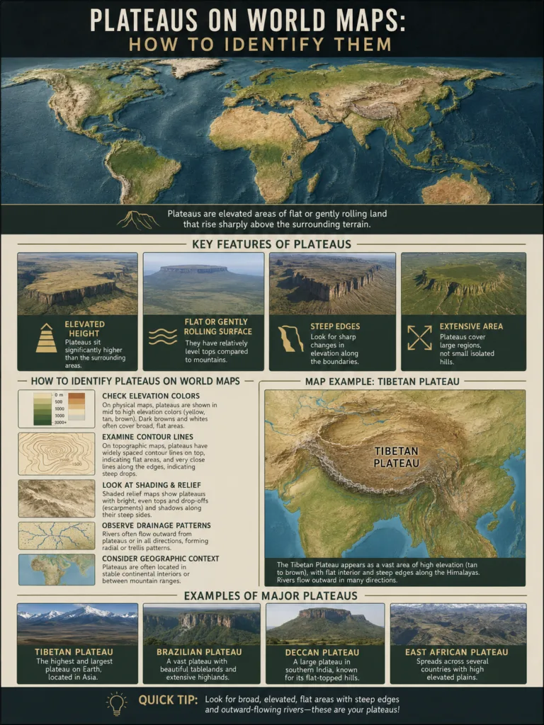
Plateaus on World Maps: How to Identify Them
A plateau on a world map is usually shown as a broad area of elevated land...
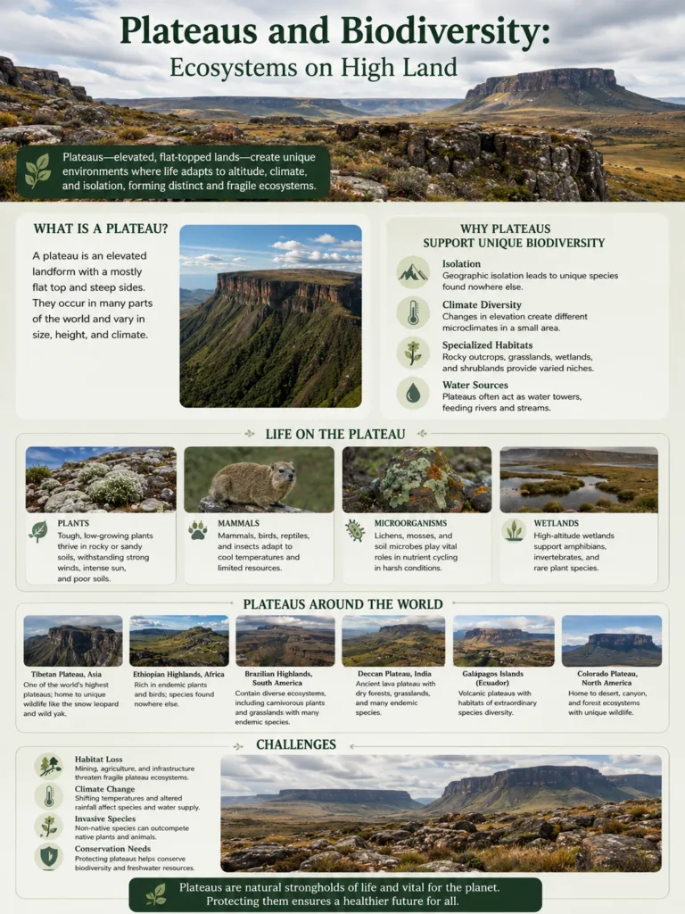
Plateaus and Biodiversity: Ecosystems on High Land
High plateaus often look open and simple from a distance: broad uplands, dry plains, grasslands, rocky...
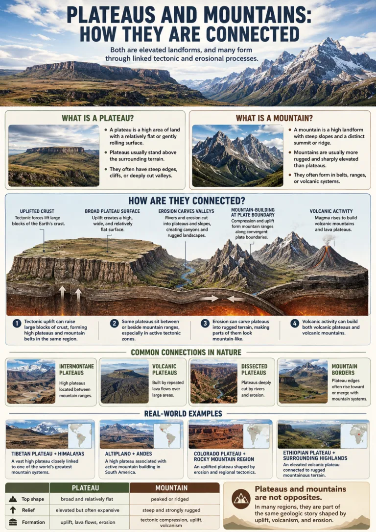
Plateaus and Mountains: How They Are Connected
Plateaus and mountains are connected because both are elevated landforms, both can rise through tectonic forces,...
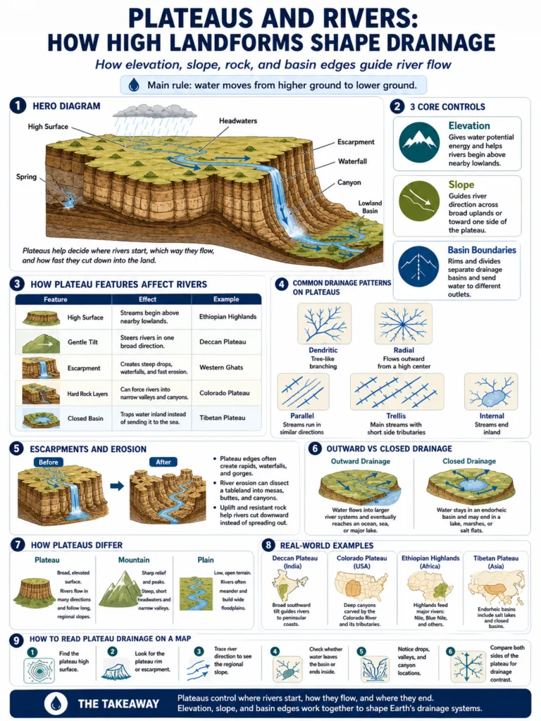
Plateaus and Rivers: How High Landforms Shape Drainage
Plateaus shape rivers by lifting broad areas of land above nearby lowlands. Rain, snowmelt, and groundwater...
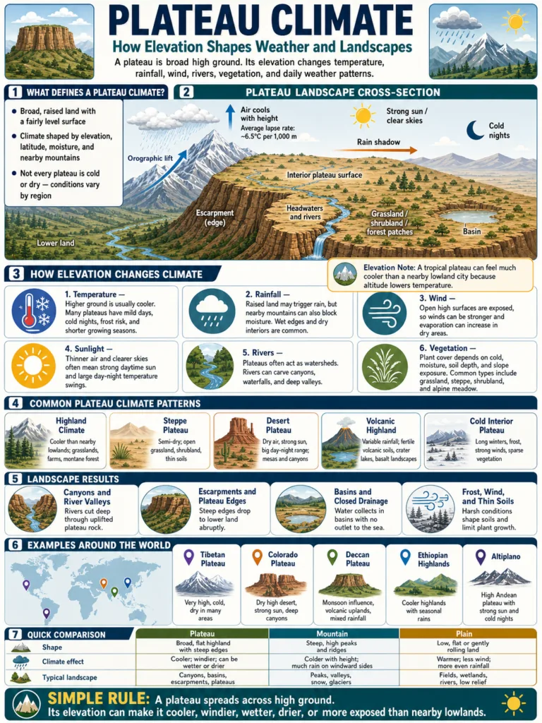
Plateau Climate: How Elevation Shapes Weather and Landscapes
A plateau climate is shaped first by elevation. A plateau may sit in the tropics, a...
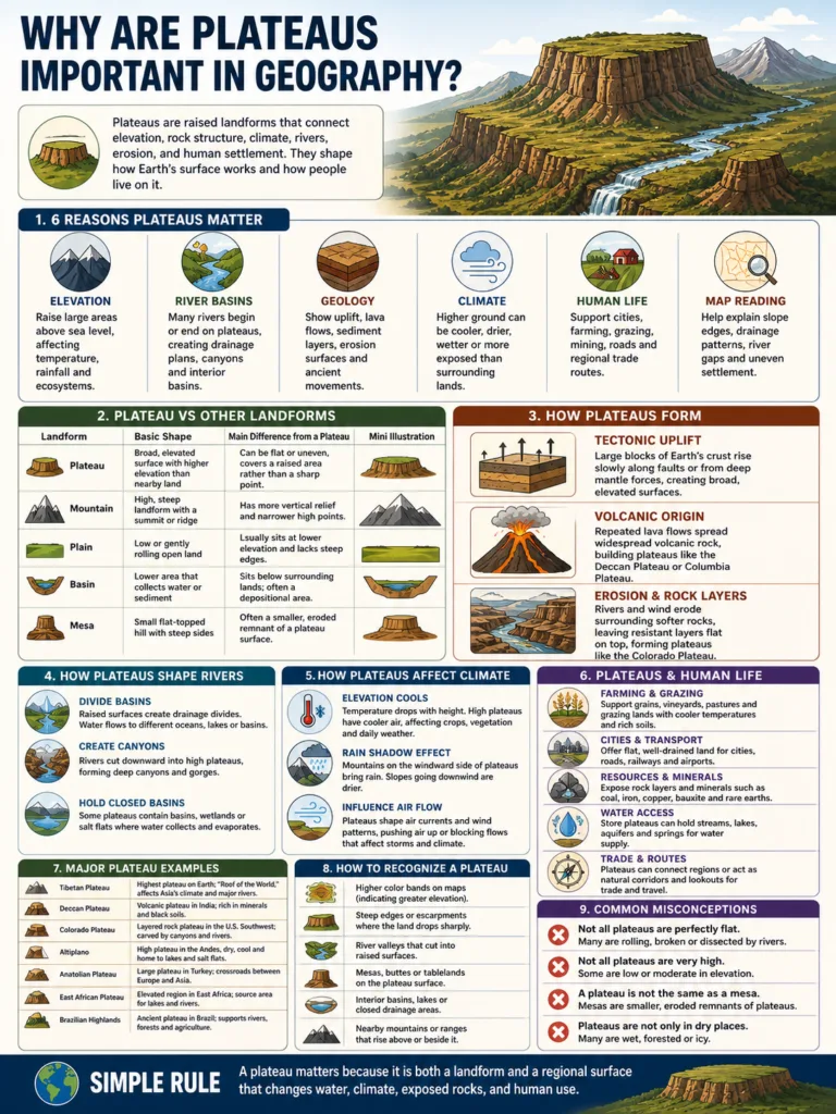
Why Are Plateaus Important in Geography?
Plateaus are important in geography because they show how elevation, rock structure, climate, rivers, erosion and...
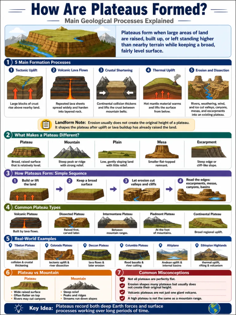
How Are Plateaus Formed? Main Geological Processes Explained
Plateaus form when large areas of land are raised, built up, or left standing higher than...
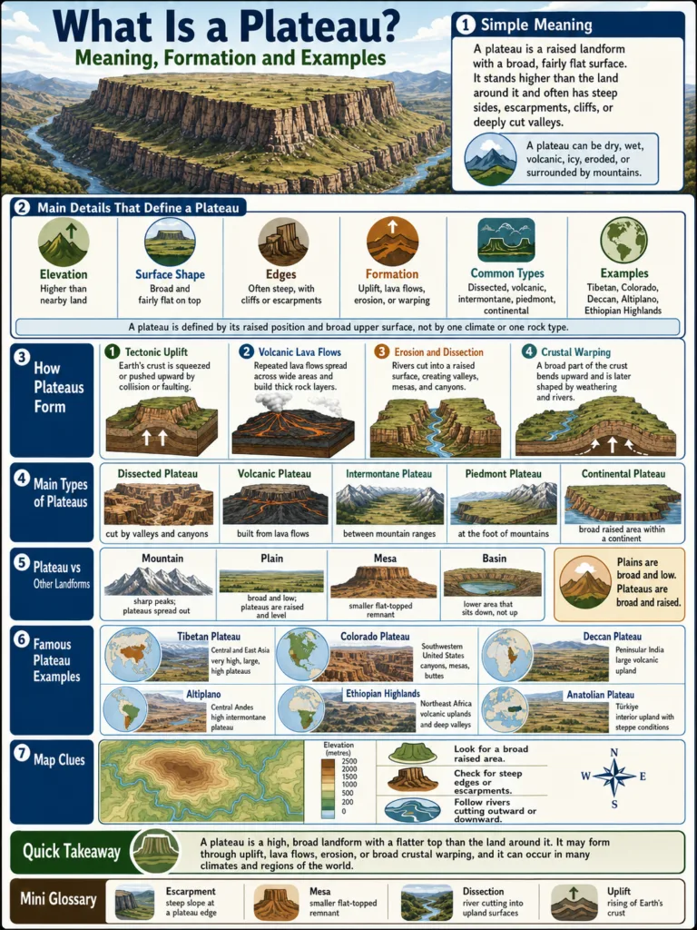
What Is a Plateau? Meaning, Formation and Examples
A plateau is a raised landform with a broad, fairly flat surface. It stands higher than...
8 articles in World Plateaus
World plateaus are broad raised landforms that sit higher than nearby lowlands while keeping a wide, fairly level surface. Some rise between mountain belts, some spread across dry interiors, and others are built from old lava flows or long erosion. Together, they shape climate, rivers, soils, settlement patterns, and the way continents look on a physical map.
A plateau does not need to be perfectly flat. Many are cut by canyons, basins, valleys, escarpments, volcanic cones, dry lake beds, or river gorges. The shared idea is simple: a plateau is elevated land with broad surface relief, not a single peak and not a low plain.
Major Plateaus of the World: 150 Plateau Regions
The list below sets a practical boundary for a world plateau reference page. It includes major plateaus, highlands, tablelands, shield uplands, ice-covered plateaus, and several large undersea plateaus that are important in physical geography.
| # | Plateau / Highland Region | Continent or Region | Main Location | Technical Identity |
|---|---|---|---|---|
| 1 | Tibetan / Qinghai-Tibet Plateau | Asia | China, Tibet, Qinghai and Himalayan margin | Highest large tectonic plateau and Asian river source region |
| 2 | Iranian Plateau | Asia | Iran, Afghanistan, Pakistan and nearby highlands | Intermontane plateau with deserts and enclosed basins |
| 3 | Deccan Plateau | Asia | Peninsular India | Large basalt and ancient shield plateau |
| 4 | Mongolian Plateau | Asia | Mongolia and northern China | Cold continental plateau and steppe upland |
| 5 | Loess Plateau | Asia | North-central China | Wind-deposited silt plateau cut by erosion |
| 6 | Yunnan-Guizhou Plateau | Asia | Southwest China | Karst, basins and dissected upland plateau |
| 7 | Anatolian Plateau | Asia / Europe | Central and eastern Turkey | Tectonic plateau with basins, steppe and volcanic uplands |
| 8 | Armenian Plateau | Asia | Eastern Turkey, Armenia and neighboring highlands | Volcanic and tectonic highland plateau |
| 9 | Arabian Plateau | Asia | Arabian Peninsula | Arid plateau, escarpment and desert tableland system |
| 10 | Central Siberian Plateau | Asia | Russia, between the Yenisei and Lena basins | Large ancient plateau and trap basalt region |
| 11 | Ustyurt Plateau | Asia | Kazakhstan, Uzbekistan and Turkmenistan | Arid plateau with steep escarpment margins |
| 12 | Pamir Plateau / High Pamir | Asia | Tajikistan, Afghanistan, China and Kyrgyzstan | High mountain plateau and intermontane basin system |
| 13 | Shan Plateau | Asia | Myanmar and mainland Southeast Asia | Limestone and dissected upland plateau |
| 14 | Khorat Plateau | Asia | Northeast Thailand and Laos margin | Low sedimentary plateau and basin landscape |
| 15 | Chota Nagpur Plateau | Asia | Eastern India | Mineral-rich dissected plateau |
| 16 | Malwa Plateau | Asia | Central India | Lava-derived regional plateau |
| 17 | Mysore Plateau | Asia | Southern India | Southern peninsular upland plateau |
| 18 | Baghelkhand Plateau | Asia | Central India | Regional upland and dissected plateau |
| 19 | Bundelkhand Plateau | Asia | North-central India | Old rocky plateau and granitic upland |
| 20 | Shillong Plateau | Asia | Northeast India | Raised block plateau with heavy monsoon rainfall |
| 21 | Ladakh Plateau | Asia | Northern India, Trans-Himalaya | High cold desert plateau |
| 22 | Qaidam Basin Plateau Region | Asia | Qinghai, China | High interior basin on the northern Tibetan margin |
| 23 | Ordos Plateau | Asia | Inner Mongolia and northern China | Dry plateau and Yellow River bend region |
| 24 | Alashan Plateau | Asia | Inner Mongolia and Gobi region | Desert plateau and arid basin upland |
| 25 | Ala Plateau / Alay Valley Uplands | Asia | Kyrgyzstan and Tajikistan margin | High intermontane plateau and valley system |
| 26 | Turgay Plateau | Asia | Kazakhstan | Low plateau and steppe corridor |
| 27 | Kazak Uplands | Asia | Central Kazakhstan | Ancient low mountains and plateau-like uplands |
| 28 | Putorana Plateau | Asia | Northern Siberia, Russia | Basalt plateau with deep valleys and lakes |
| 29 | Lena Plateau | Asia | Eastern Siberia, Russia | River-cut plateau along the Lena basin |
| 30 | Aldan Plateau | Asia | Eastern Siberia, Russia | Cold shield upland and dissected plateau |
| 31 | Vitim Plateau | Asia | Siberia, Russia | Volcanic and upland plateau near the Vitim basin |
| 32 | Kolyma Plateau | Asia | Northeastern Siberia | Cold dissected upland plateau |
| 33 | Golan Heights | Asia | Levant | Basaltic plateau and strategic upland |
| 34 | Negev Highlands | Asia | Southern Israel | Arid upland plateau and desert highland |
| 35 | Dieng Plateau | Asia | Java, Indonesia | Volcanic plateau with calderas and lakes |
| 36 | Kintamani / Bali Volcanic Plateau | Asia | Bali, Indonesia | Volcanic highland plateau |
| 37 | Khorasan Plateau | Asia | Northeastern Iran and nearby uplands | Dry interior plateau and mountain-framed basins |
| 38 | Dasht-e Kavir Plateau Margins | Asia | Central Iran | Salt desert plateau basin system |
| 39 | Dasht-e Lut Plateau Margins | Asia | Eastern Iran | Arid plateau and desert basin landscape |
| 40 | Kurdish / Zagros Plateau Uplands | Asia | Zagros region of Iran, Iraq and Turkey | Folded mountain-front plateau and highland basins |
| 41 | Ethiopian Highlands | Africa | Ethiopia and Eritrean margin | High volcanic plateau and rift-related upland |
| 42 | East African Plateau | Africa | Kenya, Tanzania, Uganda and nearby regions | Broad uplifted plateau with rift valleys |
| 43 | South African Highveld | Africa | South Africa | Interior plateau and grassland highveld |
| 44 | Bie Plateau | Africa | Central Angola | River-source plateau and interior upland |
| 45 | Jos Plateau | Africa | Central Nigeria | Granite highland and tableland region |
| 46 | Fouta Djallon | Africa | Guinea and West Africa | Highland plateau and river headwater region |
| 47 | Ahaggar / Hoggar Plateau | Africa | Southern Algeria | Saharan volcanic and crystalline upland |
| 48 | Katanga Plateau | Africa | DR Congo and Zambia margin | Mineral plateau and southern African upland |
| 49 | Tassili n Ajjer | Africa | Southeastern Algeria | Sandstone plateau with Saharan escarpments |
| 50 | Tibesti Plateau | Africa | Chad and Libya | Volcanic Saharan highland plateau |
| 51 | Ennedi Plateau | Africa | Northeastern Chad | Sandstone plateau with arches and cliffs |
| 52 | Adamawa Plateau | Africa | Cameroon and Nigeria | Volcanic and highland plateau region |
| 53 | Mandara Plateau | Africa | Cameroon and Nigeria border region | Mountain-front upland and plateau terrain |
| 54 | Bamenda Highlands | Africa | Western Cameroon | Volcanic highland plateau |
| 55 | Uasin Gishu Plateau | Africa | Kenya | High agricultural plateau |
| 56 | Laikipia Plateau | Africa | Kenya | Equatorial upland plateau |
| 57 | Nyika Plateau | Africa | Malawi and Zambia | High grassland plateau |
| 58 | Waterberg Plateau | Africa | Namibia | Sandstone plateau and escarpment landscape |
| 59 | Khomas Hochland | Africa | Central Namibia | Interior highland plateau |
| 60 | Zimbabwe Highveld | Africa | Zimbabwe | Central plateau and watershed upland |
| 61 | Lesotho Highlands | Africa | Lesotho and Drakensberg region | High basaltic plateau and mountain upland |
| 62 | Madagascar Central Highlands | Africa | Madagascar | Island highland plateau and dissected upland |
| 63 | Djado Plateau | Africa | Niger and Sahara | Desert plateau and escarpment region |
| 64 | Air Mountains Plateau Region | Africa | Niger | Saharan highland and plateau terrain |
| 65 | Colorado Plateau | North America | United States: Utah, Arizona, Colorado and New Mexico | Dissected plateau with canyon systems |
| 66 | Columbia Plateau | North America | Northwestern United States | Large flood-basalt lava plateau |
| 67 | Mexican Plateau | North America | Northern and central Mexico | High interior plateau between mountain ranges |
| 68 | Appalachian Plateau | North America | Eastern United States | Dissected plateau along the Appalachian region |
| 69 | Ozark Plateau | North America | Missouri, Arkansas, Oklahoma and Kansas | Ancient dissected upland plateau |
| 70 | Edwards Plateau | North America | Texas, United States | Limestone plateau and karst landscape |
| 71 | Llano Estacado | North America | Texas and New Mexico, United States | Flat tableland on the High Plains |
| 72 | Yukon-Tanana Upland | North America | Alaska and Yukon region | Northern upland plateau terrain |
| 73 | Allegheny Plateau | North America | Pennsylvania, New York and nearby states | Dissected Appalachian plateau section |
| 74 | Cumberland Plateau | North America | Tennessee, Kentucky, Alabama and Georgia | Sandstone plateau and escarpment landscape |
| 75 | Piedmont Plateau | North America | Eastern United States | Foothill plateau between Appalachians and coastal plain |
| 76 | Missouri Plateau | North America | Northern Great Plains, United States | Dissected plains and plateau-like upland |
| 77 | High Plains / Great Plains Tableland | North America | Central United States | Broad elevated plains and tableland |
| 78 | Fraser Plateau | North America | British Columbia, Canada | Interior plateau between mountain belts |
| 79 | Thompson Plateau | North America | British Columbia, Canada | Interior upland plateau |
| 80 | Interior Plateau of British Columbia | North America | Western Canada | Mountain-framed plateau system |
| 81 | Cumberland Mountains Plateau Region | North America | Southeastern United States | Dissected plateau and ridge terrain |
| 82 | Raton Mesa Region | North America | Colorado and New Mexico, United States | Mesa-tableland plateau margin |
| 83 | Kaibab Plateau | North America | Northern Arizona, United States | High limestone plateau near Grand Canyon |
| 84 | San Francisco Plateau | North America | Arizona, United States | Volcanic plateau terrain |
| 85 | Mogollon Plateau / Rim Country | North America | Arizona and New Mexico | Escarpment-bounded plateau region |
| 86 | Uncompahgre Plateau | North America | Western Colorado, United States | Uplifted plateau and canyon landscape |
| 87 | Coconino Plateau | North America | Northern Arizona, United States | Colorado Plateau subregion |
| 88 | Maya Mountains Plateau Region | North America | Belize and Guatemala | Tropical upland and plateau terrain |
| 89 | Laurentian Upland | North America | Canadian Shield region | Ancient shield upland and plateau-like terrain |
| 90 | Altiplano | South America | Bolivia, Peru, Chile and Argentina | High Andean intermontane plateau |
| 91 | Puna de Atacama | South America | Argentina and Chile | Arid high plateau in the Central Andes |
| 92 | Brazilian Highlands | South America | Brazil | Large ancient plateau and upland shield |
| 93 | Guiana Highlands | South America | Venezuela, Guyana, Suriname and Brazil | Shield plateau with tepui tablelands |
| 94 | Patagonian Plateau | South America | Southern Argentina | Steppe plateau and volcanic tableland terrain |
| 95 | Mato Grosso Plateau | South America | Central Brazil | Interior plateau and watershed region |
| 96 | Chapada Diamantina | South America | Bahia, Brazil | Dissected plateau and escarpment landscape |
| 97 | Chapada dos Guimaraes | South America | Mato Grosso, Brazil | Sandstone plateau and canyon terrain |
| 98 | Chapada dos Veadeiros | South America | Goias, Brazil | Ancient quartzite plateau |
| 99 | Borborema Plateau | South America | Northeastern Brazil | Crystalline upland plateau |
| 100 | Parana Plateau | South America | Southern Brazil and neighboring regions | Basalt plateau and river basin upland |
| 101 | Sao Francisco Plateau Region | South America | Eastern Brazil | Watershed plateau and highland basin |
| 102 | Auyantepui | South America | Venezuela | Tepui tableland within Guiana Highlands |
| 103 | Mount Roraima Tepui | South America | Venezuela, Guyana and Brazil border | Flat-topped tepui plateau |
| 104 | Gran Sabana | South America | Venezuela | Savanna plateau and tepui landscape |
| 105 | Cundiboyacense Plateau | South America | Colombia | High Andean plateau basin |
| 106 | Quito Plateau / Inter-Andean Valley | South America | Ecuador | High basin and plateau corridor |
| 107 | Bogota Savanna | South America | Colombia | High Andean plateau plain |
| 108 | Iberian Meseta | Europe | Spain and Portugal | Large interior plateau of the Iberian Peninsula |
| 109 | Massif Central | Europe | France | Old volcanic and crystalline upland plateau |
| 110 | Central Russian Upland | Europe | Western Russia | Broad erosional upland plateau |
| 111 | Swiss Plateau | Europe | Switzerland | Foreland plateau between Alps and Jura |
| 112 | Bohemian-Moravian Highlands | Europe | Czech Republic | Old upland plateau and watershed region |
| 113 | Podolian Upland | Europe | Ukraine and Moldova region | Dissected upland plateau |
| 114 | Valdai Hills / Valdai Upland | Europe | Western Russia | Glacially shaped upland plateau |
| 115 | Volga Upland | Europe | European Russia | River-cut upland plateau |
| 116 | Dinaric Karst Plateau | Europe | Western Balkans | Karst plateau and limestone highland |
| 117 | Karst Plateau | Europe | Slovenia and northeastern Italy | Classic limestone karst plateau |
| 118 | Swabian Jura Plateau | Europe | Germany | Limestone plateau and cuesta landscape |
| 119 | Franconian Jura Plateau | Europe | Germany | Karst plateau and upland region |
| 120 | Bavarian Plateau | Europe | Southern Germany | Foreland plateau north of the Alps |
| 121 | Hardangervidda | Europe | Norway | High mountain plateau |
| 122 | Finnmarksvidda | Europe | Northern Norway | Arctic plateau and tundra upland |
| 123 | Smaland Highlands | Europe | Southern Sweden | Old shield upland plateau |
| 124 | Sila Plateau | Europe | Southern Italy | Mountain plateau in Calabria |
| 125 | Tarn Plateau / Grands Causses | Europe | Southern France | Limestone plateau and canyon country |
| 126 | Scottish Southern Uplands | Europe | Scotland, United Kingdom | Dissected upland plateau terrain |
| 127 | Western Plateau | Australia / Oceania | Western and central Australia | Large ancient shield plateau |
| 128 | Barkly Tableland | Australia / Oceania | Northern Territory and Queensland | Low tableland and savanna plateau |
| 129 | Nullarbor Plain | Australia / Oceania | South Australia and Western Australia | Limestone plateau and karst plain |
| 130 | Kimberley Plateau | Australia / Oceania | Northwestern Australia | Dissected sandstone plateau |
| 131 | Atherton Tableland | Australia / Oceania | Queensland, Australia | Volcanic tableland and tropical upland |
| 132 | Arnhem Land Plateau | Australia / Oceania | Northern Territory, Australia | Sandstone plateau and escarpment country |
| 133 | New England Tableland | Australia / Oceania | New South Wales, Australia | High tableland and basalt upland |
| 134 | Monaro Tableland | Australia / Oceania | New South Wales, Australia | Cool upland tableland |
| 135 | Central Plateau of Tasmania | Australia / Oceania | Tasmania, Australia | Lake-studded highland plateau |
| 136 | Canterbury High Country Plateau Region | Australia / Oceania | South Island, New Zealand | Intermontane basins and upland plateau country |
| 137 | Volcanic Plateau of New Zealand | Australia / Oceania | North Island, New Zealand | Volcanic plateau with calderas and geothermal fields |
| 138 | Papuan Central Highlands Plateau Region | Australia / Oceania | New Guinea | Tropical mountain plateau and highland valleys |
| 139 | Hamersley Plateau | Australia / Oceania | Western Australia | Iron-rich plateau and ancient craton upland |
| 140 | Antarctic Plateau | Antarctica | Interior East Antarctica | Ice-covered polar plateau above high bedrock |
| 141 | Polar Plateau of East Antarctica | Antarctica | East Antarctic Ice Sheet interior | High ice surface and polar desert plateau |
| 142 | Kerguelen Plateau | Oceanic / undersea | Southern Indian Ocean | Large submarine volcanic plateau |
| 143 | Mascarene Plateau | Oceanic / undersea | Western Indian Ocean | Submarine plateau and island ridge system |
| 144 | Ontong Java Plateau | Oceanic / undersea | Western Pacific Ocean | Very large oceanic basalt plateau |
| 145 | Manihiki Plateau | Oceanic / undersea | South Pacific Ocean | Submarine volcanic plateau |
| 146 | Shatsky Rise | Oceanic / undersea | Northwest Pacific Ocean | Large oceanic plateau and volcanic rise |
| 147 | Agulhas Plateau | Oceanic / undersea | Southwest Indian Ocean | Submarine plateau south of Africa |
| 148 | Broken Ridge | Oceanic / undersea | Indian Ocean | Fragmented submarine plateau |
| 149 | Campbell Plateau | Oceanic / undersea | South of New Zealand | Large mostly submerged continental plateau |
| 150 | Caribbean Plateau | Oceanic / undersea | Caribbean Sea | Large igneous province and submarine plateau |
Geography Note: This is not an official count of every plateau on Earth. It is a curated reference list for major plateau regions and closely related highland tablelands. Smaller mesas, local uplands, lava benches, and unnamed plateau fragments can push the full count far higher.
What Counts as a Plateau?
A plateau is an elevated landform with a broad surface. It may rise sharply above surrounding land on one side or several sides, often through an escarpment, mountain front, cliff line, or deeply cut valley.
The surface can be gently rolling, dry, volcanic, icy, grassy, forested, or carved by rivers. The landform is still a plateau if it keeps a wide raised surface rather than forming a narrow ridge or isolated mountain.
Basic Features of a Plateau
- Elevation: A plateau sits higher than nearby terrain, but its height can range from a few hundred meters to more than 4,000 meters.
- Broad surface: It spreads across a wide area instead of rising as one pointed summit.
- Edges: Many plateaus have steep sides, escarpments, mountain rims, or deeply cut river valleys.
- Relief: The top may look fairly level from a distance, even when canyons, hills, or basins cut into it.
- Formation: Plateaus can form through tectonic uplift, lava flows, crustal thickening, erosion, or a mix of these processes.
Why Plateaus Matter in Geography
Plateaus affect how water moves, where rivers begin, how climates differ from lowlands, and where people build roads, farms, towns, and reservoirs. In many regions, a plateau acts as a river divide, sending water toward different basins.
They also help explain why two nearby places can feel very different. A lowland may be warm and humid, while the plateau above it is cooler, windier, and drier.
Main Types of Plateaus
World plateaus are often grouped by how they formed and where they sit. These categories overlap, but they help make large landforms easier to read.
| Plateau Type | How It Forms | Typical Features | Examples |
|---|---|---|---|
| Intermontane Plateau | Raised or trapped between mountain ranges | High basins, dry interiors, mountain rims | Tibetan Plateau, Altiplano, Iranian Plateau |
| Volcanic Plateau | Built by repeated lava flows or volcanic eruptions | Basalt layers, dark soils, step-like surfaces | Deccan Plateau, Columbia Plateau, Ethiopian Highlands |
| Dissected Plateau | Raised land later cut by rivers and erosion | Canyons, mesas, buttes, escarpments | Colorado Plateau, Ozark Plateau, parts of the Brazilian Highlands |
| Piedmont Plateau | Sits at the foot of a mountain range | Gently sloping upland between mountains and plains | Piedmont areas east of the Appalachians |
| Shield Plateau | Developed on very old continental crust | Ancient rocks, worn surfaces, broad uplands | Western Plateau of Australia, parts of Africa and South America |
Landform Note: A plateau type describes the main pattern, not every detail. A single plateau can be volcanic, uplifted, and dissected by rivers at the same time.
Selected Major Plateaus Explained
The best-known plateaus are not only large. They also connect to major rivers, mountain systems, climate zones, and regional landscapes. The examples below add short explanations for several of the best-known entries in the 150-region list.
Tibetan Plateau
The Tibetan Plateau is often described as the highest and largest plateau on Earth. It covers a vast area of Central and East Asia, mainly across western China, and connects with the Himalaya, Karakoram, Kunlun, and other high mountain systems.
Its average elevation is commonly given at about 4,500 meters, though local heights vary widely. The plateau formed mainly through the collision and uplift linked to the Indian and Eurasian plates, which also helped raise the Himalayan region.
Its cold, dry, highland climate shapes grasslands, permafrost areas, glaciers, salt lakes, and wide basins. It is also one of Asia’s great river source regions, connected with the headwaters or upper basins of rivers such as the Yellow, Yangtze, Mekong, Salween, Brahmaputra, and Indus systems.
Altiplano of the Central Andes
The Altiplano, also called the Andean Plateau, sits high in the central Andes of South America. It spans large parts of Bolivia and Peru, with margins reaching into northern Chile and northwestern Argentina.
Many parts of the Altiplano sit around 3,300 to 3,800 meters above sea level. It lies between major Andean ranges, which makes it an intermontane plateau with high basins, salt flats, volcanic fields, and lakes.
Lake Titicaca sits on the northern part of this high plateau region. Farther south, dry basins and salt flats, including Salar de Uyuni, show how limited drainage, high elevation, and arid climate can work together.
Colorado Plateau
The Colorado Plateau covers a large part of the southwestern United States, especially the Four Corners region of Arizona, Utah, Colorado, and New Mexico. It is one of the clearest examples of a dissected plateau.
Its surface stands high, often between about 1,500 and 3,000 meters, but rivers have cut deeply into the rock layers. The Colorado River and its tributaries carved canyons, cliffs, mesas, buttes, and stair-step landscapes across the region.
The Grand Canyon is the most famous landform cut into this plateau system. The plateau itself is broader than the canyon, and that difference matters: the canyon is a river-cut feature, while the plateau is the raised landmass that the river cuts through.
Deccan Plateau
The Deccan Plateau covers much of peninsular India, south of the Indo-Gangetic Plain. It is bounded in broad terms by the Western Ghats, Eastern Ghats, and the older upland blocks of central and southern India.
Many parts sit between about 300 and 900 meters above sea level. The northwestern Deccan is linked with the Deccan Traps, a huge volcanic province built from ancient lava flows. These basaltic rocks helped form dark, fertile soils in several areas.
The plateau affects major river systems, including the Godavari, Krishna, and Kaveri. Some rivers flow eastward across the plateau toward the Bay of Bengal, while others drain toward the Arabian Sea or nearby basins.
Ethiopian Highlands
The Ethiopian Highlands form one of Africa’s most raised and rugged plateau regions. Much of the highland area stands above 1,500 meters, with peaks and uplands rising far higher in some places.
This plateau region was shaped by uplift, volcanism, and rifting. The land is cut by deep valleys and bordered by steep escarpments, especially near the East African Rift system.
The highlands help feed the Blue Nile system, which begins from Lake Tana and cuts through deep valleys before flowing toward Sudan. The contrast between cool uplands and lower dry areas is one reason this region stands out on climate and elevation maps.
East African Plateau
The East African Plateau stretches across parts of Kenya, Tanzania, Uganda, and nearby regions. It is a broad raised area broken by rift valleys, volcanic mountains, lakes, and high basins.
Large areas sit around 1,000 to 1,500 meters, though elevation changes from place to place. The plateau is closely linked with the East African Rift, where crustal stretching, volcanic activity, and uplift have shaped the land.
Lake Victoria lies within this wider highland setting, while rift lakes such as Tanganyika and Malawi occupy deep troughs along rift zones. This makes East Africa a good example of how a plateau can contain basins, lakes, escarpments, and volcanic peaks.
Brazilian Highlands
The Brazilian Highlands cover a broad part of eastern, central, and southern Brazil. They are not one flat table. They include old uplands, escarpments, plateaus, ridges, river valleys, and worn shield landscapes.
Many areas range from about 300 to 1,200 meters, though some ridges and uplands rise higher. The region helps divide drainage toward major river systems, including the Paraná and São Francisco basins.
The eastern edge includes steep slopes and uplands near the Atlantic side of Brazil. Farther inland, the surface becomes a mix of rolling highlands, plateaus, and basins.
Guiana Highlands
The Guiana Highlands sit in northern South America, across parts of Venezuela, Guyana, Suriname, French Guiana, and northern Brazil. The region is known for old rocks, forested uplands, and flat-topped mountains called tepuis.
Tepuis are not the same as one continuous plateau, but they show a related tableland form. Many have steep sides and flat summits, created by long erosion of resistant rock layers.
The Guiana Highlands help divide drainage between the Orinoco, Amazon, and Atlantic-facing river systems. Their landscape shows how ancient rock surfaces can be lifted, worn down, and cut into isolated tablelands.
Central Siberian Plateau
The Central Siberian Plateau lies between the Yenisei and Lena river systems in northern Asia. It is a vast, cold interior plateau with broad uplands, river valleys, forests, tundra margins, and basaltic rock areas.
Much of it is moderate in elevation compared with the Tibetan Plateau, often around several hundred meters high, though local terrain varies. Its climate is strongly continental, with long cold seasons and large temperature ranges.
Major rivers and tributaries cut through the region, including branches linked with the Yenisei and Lena basins. This makes river valleys a main way to read the plateau on a map.
Iranian Plateau
The Iranian Plateau covers a large highland region across Iran and nearby parts of Afghanistan and Pakistan. It sits between major mountain belts, including the Zagros, Alborz, Kopet Dag, and ranges toward the Hindu Kush region.
Many parts are dry, high, and basin-like. Elevations often range from about 900 to 1,500 meters, with higher mountain rims around the plateau.
The landscape includes interior deserts, salt flats, enclosed basins, and mountain-fed drainage. Many streams do not reach the sea; instead, they end in desert basins or seasonal lakes.
Anatolian Plateau
The Anatolian Plateau occupies much of central Türkiye. It sits between the Pontic Mountains to the north and the Taurus Mountains to the south, with higher terrain toward eastern Anatolia.
Large parts of central Anatolia are around 900 to 1,500 meters above sea level. The region includes dry basins, steppe landscapes, volcanic cones, salt lakes, and river valleys.
The Kızılırmak and Sakarya systems drain important parts of the plateau. Closed basins, including the area around Lake Tuz, show how dry climate and internal drainage shape parts of central Anatolia.
Mexican Plateau
The Mexican Plateau lies between the Sierra Madre Occidental and Sierra Madre Oriental. It covers much of northern and central Mexico and includes basins, volcanic areas, and high interior plains.
Elevation varies widely, but many areas stand roughly between 1,000 and 2,500 meters. The southern part is generally higher and more closely linked with volcanic belts and central highland basins.
This plateau helps explain why large inland cities can sit at high elevation while coastal lowlands remain much warmer. It is a clear example of how elevation changes climate within the same country.
Columbia Plateau
The Columbia Plateau lies in the northwestern United States, mainly across parts of Washington, Oregon, and Idaho. It is a volcanic plateau built largely from repeated basalt lava flows.
The Columbia and Snake rivers cut through the region, creating valleys, canyons, and flood-carved features. Its surface shows how lava sheets can create a broad plateau, then rivers and later erosion reshape it.
Western Plateau of Australia
The Western Plateau covers much of Australia’s interior and western landmass. It is an old, broad, worn-down plateau on ancient continental crust.
It is not as high as the Tibetan Plateau or Altiplano. Many areas are low to moderate in elevation, but the land remains a raised, ancient surface compared with surrounding coastal plains and basins.
Dry climate, desert landscapes, rocky uplands, and long-eroded surfaces are common. This plateau shows that a major plateau does not need extreme height to matter in continental geography.
Antarctic Plateau
The Antarctic Plateau is different from most other examples because its surface is dominated by thick ice. It lies across the high interior of East Antarctica and includes some of the coldest, driest conditions on Earth.
Large areas of the ice surface stand above 3,000 meters. In landform terms, it is often discussed as a high polar plateau, but it should not be confused with a warm or exposed rock tableland.
Its climate is a polar desert: very cold, very dry, and shaped by elevation, ice, and distance from the ocean.
Major Plateaus by Continent
Every continent has plateau regions, but they do not all look alike. Some are high and young in geologic terms. Others are ancient, worn, and lower in elevation.
| Continent | Major Plateau Examples | Common Plateau Pattern | Map Clue |
|---|---|---|---|
| Asia | Tibetan Plateau, Iranian Plateau, Anatolian Plateau, Central Siberian Plateau, Deccan Plateau | High intermontane plateaus, old volcanic plateaus, broad interior uplands | Look for raised regions between mountain belts or large river source areas |
| South America | Altiplano, Brazilian Highlands, Guiana Highlands, Patagonian tablelands | Andean high basins, ancient shield uplands, dissected tablelands | Look along the Andes and across eastern shield regions |
| North America | Colorado Plateau, Columbia Plateau, Mexican Plateau, Ozark Plateau | Dissected plateaus, lava plateaus, high interior basins | Look for canyons, mesas, lava plains, and uplands between mountain ranges |
| Africa | Ethiopian Highlands, East African Plateau, Southern African Plateau | Raised continental interiors, rifted highlands, volcanic uplands | Look for high interior surfaces cut by rifts and river valleys |
| Australia | Western Plateau, Kimberley Plateau, Arnhem Land Plateau | Ancient shield surfaces and dry tablelands | Look for broad old uplands away from the eastern coastal ranges |
| Europe | Meseta Central, Massif Central, Anatolian edge regions | Older uplands, volcanic plateaus, interior tablelands | Look for raised interiors near mountain belts and old rock massifs |
| Antarctica | Antarctic Plateau | Ice-covered polar plateau | Look for the high interior ice surface of East Antarctica |
How Plateaus Form
Plateaus form when large areas of land are raised, built, or left standing above nearby terrain. The process can take millions of years, and many plateaus have more than one origin.
Tectonic Uplift
Tectonic uplift raises wide blocks of crust. This can happen near colliding plates, rift zones, or broad crustal movements. The Tibetan Plateau is the best-known high example, while parts of East Africa show uplift linked with rifting.
Volcanic Lava Flows
Some plateaus form when lava spreads across wide areas in repeated flows. Over time, stacked basalt layers create a raised surface. The Deccan Plateau and Columbia Plateau both show this pattern.
Crustal Thickening Between Mountains
Intermontane plateaus can sit between mountain ranges where the crust has been shortened, thickened, or trapped in high basins. The Altiplano and Iranian Plateau both show how mountain belts can frame a high interior.
Erosion and Dissection
Rivers, wind, ice, and weathering do not only wear plateaus down. They also reveal them. A raised surface may become easier to identify after rivers cut valleys, canyons, and escarpments into it.
Common Mix-Up: A canyon inside a plateau is not the plateau itself. The canyon is a cut feature; the plateau is the wider raised land surface around it.
How Plateaus Shape Rivers and Basins
Plateaus often act like high water platforms. Rain, snowmelt, springs, and groundwater move from the raised surface toward lower land. This makes many plateaus important to river basins.
On a high plateau, water may follow several paths:
- It can cut deep valleys through the plateau edge.
- It can drain into a closed basin and end in a lake, salt flat, or dry pan.
- It can start as a mountain-fed stream and grow into a major river downstream.
- It can erode soft rock layers faster than hard layers, creating cliffs, benches, and mesas.
The Tibetan Plateau is tied to several major Asian river systems. The Colorado Plateau is cut by the Colorado River and its tributaries. The Deccan Plateau helps feed east-flowing and west-flowing Indian rivers. The Ethiopian Highlands feed the Blue Nile system.
This river connection is one of the easiest ways to understand a plateau on a map. Find the high surface first, then follow where the water leaves it.
Closed Basins on Plateaus
Not all plateau water reaches the sea. In dry regions, rivers may flow into enclosed basins. There, water can evaporate and leave salts behind.
This pattern appears in parts of the Altiplano, Iranian Plateau, Anatolian Plateau, and Mexican Plateau. It explains why many plateau interiors have salt lakes, playas, marshy basins, or dry lake beds.
Climate Patterns on Large Plateaus
Elevation changes climate. A plateau can be cooler than nearby lowlands because air temperature usually drops with height. But height is only one part of the story.
Plateau climate also depends on latitude, ocean distance, wind direction, mountain barriers, and surface shape. This is why a high plateau in Tibet, a dry plateau in Iran, and an old plateau in Australia can feel so different.
Common Plateau Climate Patterns
- Highland cold: Very high plateaus often have cold nights, strong sunlight, and short growing seasons.
- Dry interiors: Plateaus behind mountain ranges may receive less moisture because mountains block humid air.
- Sharp daily range: Dry plateau air can heat by day and cool fast at night.
- Orographic effects: Plateau rims and nearby mountains can force air upward, creating wetter slopes and drier interiors.
- Steppe and grassland zones: Many plateau interiors support grasses, shrubs, and open landscapes rather than dense forest.
Climate is one reason plateaus often form clear regional boundaries. A traveler moving from lowland to plateau may notice cooler air, thinner vegetation, different crops, and wider open views even before reaching a mountain range.
How Plateaus Differ From Similar Landforms
Plateaus are often confused with mountains, plains, mesas, basins, and highlands. The differences are practical rather than perfect. Many landscapes blend one form into another.
| Landform | Basic Shape | How It Differs From a Plateau | Example Clue |
|---|---|---|---|
| Mountain | High, steep, often with peaks or ridges | A plateau has a wider raised surface instead of one main summit | Peaks and ridgelines dominate the view |
| Plain | Broad low or gently rolling land | A plain is usually lower and lacks a strong raised edge | Few steep escarpments or high rims |
| Mesa | Small flat-topped hill with steep sides | A mesa is much smaller and often cut from a larger plateau | Looks like an isolated table |
| Basin | Lower area that collects drainage | A basin can sit inside a plateau, but it is the lower receiving area | Water flows inward or collects in the center |
| Highland | Raised region with varied terrain | A highland may include plateaus, mountains, hills, and valleys | More general term than plateau |
| Escarpment | Steep slope or cliff-like edge | An escarpment is often the edge of a plateau, not the whole plateau | Marks a sudden height change |
Simple Rule for Remembering a Plateau
A plateau is high like a mountain area but wide like a plain. It may be cut, tilted, folded, volcanic, dry, icy, or grassy, but its raised broad surface is the main clue.
How To Read Plateaus on a Map
A physical map can show plateaus even when the word “plateau” is not printed. The trick is to read elevation, slope, rivers, and landform edges together.
Map Clues That Point to a Plateau
- Look for broad elevation color: Many physical maps use brown, tan, or orange shading for raised land.
- Check for steep margins: Escarpments, cliffs, or mountain fronts may mark the plateau edge.
- Follow rivers: Rivers often begin on plateaus or cut away from them into lower basins.
- Notice enclosed basins: Dry plateau interiors may show salt lakes, playas, or rivers that do not reach the sea.
- Compare nearby lowlands: A plateau is easier to identify when placed beside surrounding plains, basins, or coastal zones.
Names can also help. Words such as plateau, highlands, tableland, altiplano, meseta, upland, and shield often point toward raised land. They are not exact synonyms, but they often appear near plateau landscapes.
World Plateau Examples by Landscape Pattern
Another useful way to group plateaus is by what they look like on the ground. This helps separate a cold high plateau from a dry shield plateau or a canyon-cut tableland.
| Landscape Pattern | What It Looks Like | Plateau Examples |
|---|---|---|
| High Mountain-Framed Plateau | Raised basins and plains between large mountain ranges | Tibetan Plateau, Altiplano, Iranian Plateau |
| Canyon-Cut Plateau | Broad upland carved by rivers into cliffs and deep valleys | Colorado Plateau, parts of the Guiana Highlands |
| Lava Plateau | Layered basalt surfaces formed by old lava flows | Deccan Plateau, Columbia Plateau, Ethiopian Highlands |
| Ancient Shield Plateau | Old worn rock surface with dry interiors or rolling uplands | Western Plateau of Australia, Brazilian Highlands |
| Ice-Covered Plateau | High polar surface covered by thick ice | Antarctic Plateau |
This pattern-based view is useful because the word plateau can describe very different places. The Colorado Plateau and the Antarctic Plateau share the raised broad-surface idea, but their climate, material, rivers, and surface form are far apart.