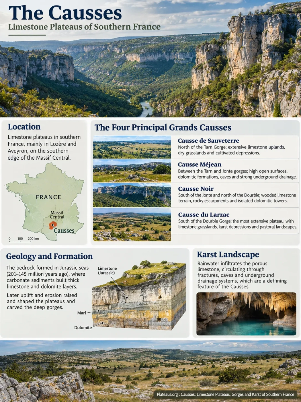
The Causses are a group of elevated limestone plateaus in southern France, along the southern edge of the Massif Central. Their broad, often sparsely wooded surfaces are cut by the deep gorges of the Tarn, Jonte, Dourbie and other rivers. Beneath the plateaus, water moves through fractured limestone, caves and underground drainage systems. Together, the plateau surfaces, river gorges and karst networks form one of France’s most distinctive limestone landscapes.
Where Are the Causses Located?
The Causses extend across parts of the Occitanie region, principally in Lozère and Aveyron, with related limestone uplands reaching into Gard and Hérault. They occupy the southern margins of the Massif Central, between older upland rocks and the lower landscapes toward the Mediterranean.
The name causse refers to a limestone plateau characteristic of this part of France. It does not designate one continuous tableland. Rivers and erosion have divided the limestone terrain into separately named plateaus, while differences in rock type and geological structure have produced local variations in elevation and relief.
The best-known group is the Grands Causses, dominated by the Causses de Sauveterre, Méjean, Noir and Larzac. Much of their plateau terrain lies roughly 600–1,200 metres (1,970–3,940 feet) above sea level, although elevations differ considerably between individual plateaus, their margins and nearby valleys.
The Four Principal Grands Causses
| Plateau | Position | Characteristic Landscape |
|---|---|---|
| Causse de Sauveterre | North of the Tarn Gorge, mainly in Lozère | Extensive limestone uplands, dry grasslands, cultivated depressions and steep southern margins |
| Causse Méjean | Between the Tarn and Jonte gorges, in Lozère | High open surfaces, dolomitic rock formations, caves and strongly developed underground drainage |
| Causse Noir | South of the Jonte and north of the Dourbie, near Millau | Wooded limestone terrain, rocky escarpments and isolated dolomitic towers |
| Causse du Larzac | South of the Dourbie Gorge, mainly in Aveyron and Hérault | The most extensive of the four principal plateaus, with limestone grasslands, karst depressions and pastoral landscapes |
Other named limestone plateaus include the Causse de Sévérac, Causse Comtal, Causse Rouge and Causse de Blandas. These belong to the broader family of causses landscapes, but their inclusion in particular regional groupings varies with the geographical definition being used.
Geographic Distinction
The Grands Causses, the Grands Causses Regional Natural Park and the UNESCO-listed Causses and Cévennes cultural landscape have different boundaries. Their names should not be treated as interchangeable area measurements.
The Boundary Between the Causses and Cévennes
East of the main limestone plateaus, the Cévennes contain extensive areas of schist, granite and other older rocks. This geological difference affects both relief and drainage. The Causses commonly display permeable limestone surfaces and subterranean water circulation; many Cévennes valleys have more strongly developed surface drainage over less permeable rocks.
The boundary is not a simple straight line. Around the eastern Causse Méjean and the Mont Aigoual area, limestone formations meet older rocks across a complex arrangement of slopes, valleys, faults and former erosion surfaces.
How Jurassic Marine Rocks Became Elevated Plateaus
The main bedrock of the Causses originated in marine environments during the Jurassic Period, approximately 201–145 million years ago. At that time, shallow seas covered parts of what is now southern France. Carbonate sediments accumulated on the seabed, eventually forming thick sequences of limestone and dolomite.
These sedimentary rocks provide the geological foundation of the modern plateaus. Their present elevation, however, developed much later. The age of the limestone is therefore different from the age of the plateau relief and the age of the gorges that cut through it.
Marine Deposition and the Structure of the Bedrock
During Jurassic sedimentation, variations in sea depth, water chemistry and sediment supply produced alternating carbonate formations. Some beds became massive limestones, while others contain dolomite, marl or siliceous material.
These differences remain visible in the landscape. Thick limestone beds can support long, steep cliffs. Less resistant marly layers tend to weather into gentler slopes beneath them. Dolomitic rocks can develop irregular towers, corridors and separated blocks where fractures guide weathering and erosion.
Marine fossils and sedimentary structures preserved within the limestone establish that these rocks formed in an environment far removed from the modern uplands.
Uplift, Erosion and the Survival of High Surfaces
After Jurassic sedimentation, the region underwent episodes of emergence, weathering, erosion and renewed sediment deposition. Some of the former sedimentary cover was later stripped away, exposing older carbonate rocks.
During the Cenozoic Era, regional deformation and uplift associated with the wider tectonic evolution of southern France altered drainage gradients and raised the limestone terrain relative to surrounding valleys. Rivers progressively cut into the elevated rocks.
The resulting landscape preserves several generations of landforms. Some depressions and weathered rock surfaces began forming beneath sediments that have since disappeared. Other features, especially the deeper river valleys, developed as drainage systems became established and incision continued.
On Causse Méjean, geological investigations have identified remnants of former weathering covers and ancient karst forms. These show that the modern rock surface cannot be explained solely by rainfall dissolving exposed limestone under present-day conditions.
Why the Plateau Tops Remain Broad
Large portions of the Causses have relatively gentle relief compared with the steep valleys around them. Their surfaces include broad interfluves, shallow depressions and low rocky rises rather than continuous mountain ridges.
These uplands preserve elements of older erosion and weathering surfaces. Their present forms also reflect the distribution of carbonate beds, fractures, surface deposits and long-term rock dissolution. The deep gorges represent a younger, more concentrated phase of river erosion superimposed on this older terrain.
The Gorges That Divide the Limestone Plateaus
The Tarn, Jonte and Dourbie have cut steep-sided valleys through the carbonate uplands. In places, the difference between the plateau rim and the valley floor approaches several hundred metres, and locally can be around 500 metres.
The valleys developed through river incision, the removal of weathered material, slope erosion and rockfall. Fractures and differences in bedrock resistance influenced the shape of the gorge walls. Harder carbonate layers form cliffs, while weaker beds commonly underlie wooded slopes and accumulations of fallen rock.
Gorge depth is a local relief measurement, not the elevation of the plateau above sea level. A plateau standing 1,000 metres above sea level does not necessarily contain a 1,000-metre-deep gorge.
Gorges du Tarn: Between Sauveterre and Méjean
The Tarn River separates Causse de Sauveterre to the north from Causse Méjean to the south. Its gorge forms one of the clearest examples of river incision into the high limestone terrain.
The Tarn follows a winding course between steep rock walls, wooded slopes and narrow sections of valley floor. Places such as Sainte-Enimie, La Malène and Les Vignes occupy positions along or near this deeply entrenched river corridor.
Numerous springs emerge from the limestone along the gorge. Some are outlets for groundwater that originally infiltrated the plateau several kilometres away. The Tarn is consequently both a surface river and an important receiving channel for the surrounding karst aquifers.
Gorges de la Jonte: Between Méjean and Noir
The Jonte Gorge separates Causse Méjean from Causse Noir. The river flows westward through a narrow limestone valley toward its meeting with the Tarn near Le Rozier.
High cliffs, projecting rock pinnacles and exposed ledges are characteristic of the gorge. Their development reflects resistant limestone and dolomite beds, joint-controlled weathering and the progressive removal of material from the valley sides.
The gorge walls also provide nesting habitat for large birds of prey, especially vultures. This connects the physical form of the canyon directly with the region’s wildlife distribution.
Gorges de la Dourbie: The Northern Edge of Larzac
South of Causse Noir, the Dourbie River cuts a deep valley along the northern margin of the Larzac plateau. The gorge extends toward the Millau area, where the Dourbie joins the Tarn.
The valley includes steep rock walls, tributary ravines, wooded slopes and narrow areas of settlement. Around La Roque-Sainte-Marguerite and Cantobre, the terrain illustrates how valley junctions and natural breaks in the escarpments influenced access and settlement.
The Dourbie also forms part of the transition between the limestone plateaus and the neighbouring Cévennes uplands.
The Vis Gorge and the Abandoned Meander at Navacelles
Farther south, the Vis River has carved a gorge through the limestone terrain associated with southern Larzac, Blandas and Campestre-et-Luc.
At the Cirque de Navacelles, the river once followed a large, tightly curved meander. The flow eventually abandoned the former loop and adopted a shorter course across its narrow neck. The old meander remains identifiable in the amphitheatre-shaped valley landscape.
The meander was naturally abandoned around 6,000 years ago. Its preserved form provides a particularly clear example of how river course changes can leave older valley geometry visible within a limestone gorge.
Karst Landforms on and Beneath the Causses
Karst develops where soluble rocks, particularly limestone and dolomite, interact with water over long periods. Rainwater absorbs carbon dioxide from the atmosphere and soil, becoming weakly acidic. As it passes through rock fractures and bedding planes, it dissolves carbonate minerals and gradually enlarges openings.
On the Causses, this process has produced closed depressions, grooved rock surfaces, vertical shafts, caves and extensive underground drainage passages. The form of each feature depends on rock composition, fracture patterns, groundwater conditions and the history of erosion.
Dolines and Soil-Filled Depressions
Dolines are closed depressions developed within karst terrain. Many form through gradual limestone dissolution and the movement of weathered material into underlying openings. Others may involve local collapse.
On the Causses, doline floors often contain deeper deposits of clay-rich soil than the surrounding rocky uplands. These depressions can support fields or more productive grassland where the plateau surface is otherwise too shallow and stony for regular cultivation.
A doline should not automatically be described as a sudden-collapse sinkhole. Its origin must be determined from its form, underlying rock structure and sediment history.
Lapiaz and Exposed Limestone Pavements
Lapiaz, also called karren, consists of grooves, fissures and separated rock blocks produced by dissolution at or near the limestone surface.
Water tends to follow joints and small surface channels, widening them unevenly. The result may be a network of narrow ridges, deep cracks and irregular stone surfaces. Lapiaz is particularly well developed where soil has been removed or is naturally thin.
Avens and Underground Cave Systems
An aven is a natural vertical opening or shaft that connects the surface with a subterranean cavity. Such shafts may develop where water moves downward through enlarged fractures or where underground dissolution and collapse modify the rock.
Aven Armand, on Causse Méjean, is a well-known example. A natural shaft approximately 75 metres deep connects the plateau surface to a large underground chamber containing numerous stalagmites.
The stalagmites formed through the precipitation of calcium carbonate from dripping water, a process distinct from the dissolution that initially enlarged the cave.
The Dargilan cave system near Meyrueis provides another example of the underground cavities developed within the limestone terrain around the Jonte valley.
Ruiniform Rocks at Nîmes-le-Vieux and Montpellier-le-Vieux
Some of the Causses’ most unusual surface forms occur in dolomitic limestone landscapes. Weathering along cracks and differences in rock resistance produces isolated pillars, narrow passages, rounded blocks and rock masses resembling ruined structures.
These are described as ruiniform landforms. They are not the remains of buildings or structures created by people.
Nîmes-le-Vieux, on the eastern Causse Méjean, contains a notable group of such features. Montpellier-le-Vieux, on Causse Noir, displays another extensive assemblage of dolomitic rock forms.
Some ruiniform features preserve traces of old weathering conditions, including periods when the rocks were covered by sediments that have since been eroded. Their development therefore reflects a longer landscape history than present-day surface runoff alone.
Where Water Flows Beneath the Dry Plateau Surfaces
Surface streams are comparatively scarce across many parts of the Causses, even where rainfall is substantial. The main reason is the permeability of fractured and karstified limestone.
Rainwater can infiltrate through shallow soils, joints, dolines and vertical openings. It then moves through connected fractures and conduits until it reaches groundwater outlets along valleys, impermeable rock boundaries or other suitable discharge points.
This creates an important difference between surface drainage and underground drainage. The divide between two visible valleys does not necessarily mark the boundary between their groundwater catchments.
Water enters fractured limestone through soil, joints, dolines and localized openings.
Water travels through fractures, porous zones and enlarged karst conduits. Flow speeds and storage conditions vary between pathways.
Groundwater reappears at springs along the gorge walls and valley floors, supplying rivers such as the Tarn and Jonte.
The Groundwater Systems of Causse Méjean
Causse Méjean has been investigated in detail because its underground water circulation is complex and its surface water resources are limited.
A hydrogeological study conducted by the French Geological Survey (BRGM) with Cévennes National Park examined the principal karst systems using geological mapping, spring monitoring, water chemistry and tracer tests.
The investigation identified several distinct groundwater systems and discharge points, including those associated with Ardennes, Castelbouc, Moulin de Pélatan, Le Pêcher, Saint-Chély, Ironselle and Les Douzes.
The results showed that the Ardennes system drains an estimated catchment of 87 km², while the Castelbouc system drains approximately 78 km². The Ardennes system was also identified as a major groundwater resource, with an estimated dynamic water reserve of about 6 million cubic metres in its saturated zone.
These values describe particular karst drainage systems within Causse Méjean. They are not measurements of the total area or total groundwater storage of the entire plateau.
How Dye Tracing Reveals Hidden Connections
One method used to identify underground drainage routes is to introduce a detectable tracer into an infiltration point and monitor selected springs for its appearance.
The Causse Méjean investigation interpreted 22 tracing operations to help delineate groundwater catchments and identify major drainage connections.
A tracer detected at a spring establishes a hydraulic connection under the conditions of the test. It does not mean that all water follows one permanent underground tunnel. Karst aquifers may contain several connected pathways, and the active routes can vary with groundwater levels and rainfall.
Groundwater Vulnerability and Water Supply
The same openings that allow rapid infiltration can also allow contaminants to enter an aquifer without passing through the filtration processes typical of thicker soil and sediment layers.
Water quality can therefore be affected by activities occurring some distance from a spring, especially where tracer studies demonstrate a direct connection.
Rainfall variability also matters. Karst springs may respond rapidly to storms, while stored groundwater can help maintain discharge during drier periods. The balance between rapid conduit flow and slower groundwater storage differs among the Causses’ aquifers.
Understanding these systems is necessary for assessing drinking-water resources, protecting springs and distinguishing groundwater catchments from the surface watersheds shown on ordinary topographic maps.
Thin Soils, Dry Grasslands and Gorge Microclimates
The surface appearance of the Causses is influenced by climate, bedrock permeability and soil depth. Much of the plateau terrain supports dry grassland, scattered shrubs and rocky ground, while some depressions contain cultivated fields and wooded areas occupy other slopes and uplands.
Why the Plateaus Can Look Dry Despite Regular Rainfall
Many plateau surfaces have thin, stony soils over fractured carbonate bedrock. These soils often retain less accessible moisture than deeper deposits, and infiltrating water may move quickly below the main root zone.
The region experiences a combination of Mediterranean, Atlantic and upland climatic influences. Rainfall varies across the area, and high elevations can experience cold winters, frost and snow.
Summer water stress can result from evaporation, shallow soils and rapid drainage. The presence of dry grassland therefore does not prove that the annual climate is extremely arid.
Why Gorge Vegetation Differs From the Plateau Surface
Deep valleys create local climatic conditions that differ from exposed uplands. Slope orientation influences sunlight and evaporation, while the valley floor may provide more sheltered conditions and access to water.
South-facing slopes often experience stronger solar heating and support vegetation adapted to drier conditions. More shaded slopes can retain moisture longer and develop denser woodland. Rock faces, scree and riverbanks add further habitat differences over short distances.
| Terrain Position | Ground and Water Conditions | Common Landscape Features |
|---|---|---|
| Open plateau | Often shallow soils, exposed bedrock and substantial infiltration | Dry grassland, shrubs, scattered woodland and rocky pavements |
| Karst depression | Accumulated fine sediments and locally deeper soils | Fields, productive grassland and enclosed hollows |
| Sunny gorge slope | High solar exposure, rocky substrates and rapid surface drying | Cliffs, scrub, dry woodland and scree |
| Shaded gorge slope | Reduced direct sunlight and locally greater moisture retention | Denser woodland, sheltered ravines and rock habitats |
| Valley floor | River water, alluvial deposits and groundwater discharge points | Riparian vegetation, springs, narrow cultivated areas and settlements |
These patterns are not uniform across every plateau. Causse Noir, for example, has extensive wooded areas, while parts of Causse Méjean and Larzac retain large expanses of open grazed land. Past land use, reforestation and the abandonment of some grazing areas have also changed the vegetation.
How Sheep Grazing Shaped the Limestone Uplands
Human land use has strongly influenced the appearance of the Causses. Extensive sheep grazing developed across the plateaus because large areas of thin, rocky soil were more suitable for pasture than for intensive crop cultivation.
Grazing helped maintain open grasslands and limited the spread of woody vegetation. Over long periods, farmers and shepherds also modified the terrain through stone clearance, water storage, animal shelters and seasonal livestock routes.
Pasture on Rock, Cultivation in Depressions
Differences in soil depth created a practical division of land use. Rocky uplands became grazing areas, while some dolines and other depressions were cultivated because they retained deeper soil.
On Larzac and other causses, this relationship between geology and agriculture remains visible in the arrangement of open pasture, small fields, stone walls and isolated farm buildings.
The open landscape is therefore not entirely a natural steppe. It reflects the combined effects of limestone geology, climatic conditions and centuries of grazing and woodland clearance.
Lavognes, Clapas and Stone-Built Pastoral Structures
Limited surface water encouraged the development of local water-management structures. Lavognes are shallow ponds or basins used to provide drinking water for livestock. Some were created by modifying natural depressions and reducing seepage through their floors.
Clapas are accumulations of stones cleared from fields or grazing land. They commonly occur as piles or elongated stone heaps and record repeated efforts to make rocky ground more usable.
Dry-stone walls divide parcels, mark routes and contain livestock. Traditional jasses, or sheep shelters, often use locally available stone and may be associated with rainwater-collection systems or cisterns.
These structures are closely tied to the environmental limitations of the limestone plateaus: abundant building stone, thin soils and the need to store water where permanent surface supplies are scarce.
Transhumance and the Drailles
Seasonal livestock movement, known as transhumance, connected grazing areas at different elevations and with different seasonal growing conditions.
Traditional routes called drailles allowed flocks to move between pastures. Their alignment across uplands and through accessible passes reflects the physical geography of the region.
Some routes remain recognizable in the landscape, even where their original pastoral use has declined or changed.
Cliff Habitats and the Return of Vultures
The Causses support a combination of open grassland, woodland, rocky escarpments and underground habitats. The deep gorges are particularly important for birds that nest on cliffs or use the uplands for feeding.
Griffon Vultures in the Tarn and Jonte Gorges
The griffon vulture (Gyps fulvus) disappeared as a breeding bird from the Grands Causses before a reintroduction programme began in the early 1980s.
Reintroduced birds established breeding colonies on the limestone cliffs, especially around the Jonte and Tarn gorges. The rock walls provide nesting ledges, while surrounding open countryside offers access to carrion.
The relationship between cliff nesting areas and extensive livestock grazing helps explain why the species is closely associated with this plateau-and-gorge landscape.
Other Vultures and Rocky Habitats
The cinereous vulture (Aegypius monachus) was also reintroduced to the Grands Causses, beginning in 1992. Unlike griffon vultures, which generally nest on cliffs, cinereous vultures typically build nests in trees.
Egyptian vultures (Neophron percnopterus) and bearded vultures (Gypaetus barbatus) are also associated with regional conservation efforts. Bearded vulture reintroduction work in the Grands Causses began in 2012.
Open limestone grasslands support different wildlife from wooded slopes, and cave systems provide habitats for bats and other organisms adapted to subterranean environments.
Changes in grazing intensity, woodland cover and disturbance around nesting sites can therefore affect species that use different parts of the same limestone landscape.
Protected Landscapes and the Future of the Causses
Several conservation designations apply to parts of the Causses. They protect different aspects of the region, including geological scenery, natural habitats and traditional pastoral land use.
The Causses and Cévennes UNESCO Cultural Landscape
In 2011, UNESCO inscribed The Causses and the Cévennes, Mediterranean Agro-Pastoral Cultural Landscape on the World Heritage List.
The inscription recognizes a living cultural landscape shaped by extensive livestock raising, seasonal movement of animals, traditional settlements, stone-built structures and long-established land management.
The World Heritage property covers 302,319 hectares (3,023.19 km²). This figure refers to the designated cultural landscape, which includes both Causses and Cévennes terrain. It is not the total area of the Causses limestone plateaus.
The UNESCO designation is cultural rather than a geological World Heritage classification, although limestone relief is fundamental to the landscape and its traditional use.
The Gorges du Tarn, de la Jonte et Causses Grand Site de France
On 21 May 2024, the Gorges du Tarn, de la Jonte et Causses received the Grand Site de France designation.
This French landscape-management label covers a particular area associated with the Tarn and Jonte gorges and adjoining causses. It recognizes efforts to conserve the character of the landscape while managing public access, local activity and pressures on sensitive sites.
The designation is separate from UNESCO World Heritage status. Cévennes National Park and the Grands Causses Regional Natural Park also have their own boundaries and management responsibilities.
Grassland Change and the Loss of Open Habitats
Where extensive grazing declines, shrubs and trees can gradually spread across formerly open pasture. This process changes habitat conditions and can reduce the extent of grassland used by species adapted to open limestone terrain.
Maintaining some of these habitats depends on continuing appropriate grazing or other forms of vegetation management. At the same time, wooded areas remain valuable components of the regional ecosystem.
Water Protection in a Fractured Limestone Landscape
Protecting the Causses’ groundwater requires attention to activities occurring across the recharge areas of springs, not only immediately around their outlets.
Karst aquifers can transmit water and pollutants through underground connections that are not visible at the surface. Agricultural runoff, wastewater and other contamination sources may therefore affect springs beyond the boundaries suggested by surface topography.
Long-term groundwater monitoring and the identification of spring catchments are especially relevant where drinking-water demand, drought conditions and variable seasonal flows place pressure on local resources.
Cliff Erosion, Access and Landscape Preservation
The steep gorge walls remain active geomorphic environments. Weathering, rockfall, slope erosion and river action continue to modify their surfaces, although generally at rates difficult to observe over short periods.
Roads, settlements, recreation and tourism concentrate along accessible valley corridors and viewpoints. Managing these activities requires attention to unstable slopes, fragile vegetation, cave environments and nesting areas on limestone cliffs.
The preservation of the Causses also depends on retaining the relationships between their connected landforms: the limestone plateau surfaces where water infiltrates, the underground aquifers that transport it, the springs that discharge into the gorges, and the pastoral landscapes developed above them.