Plateau Type • Erosion • Landform Reading
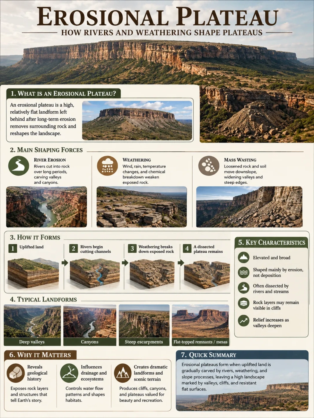
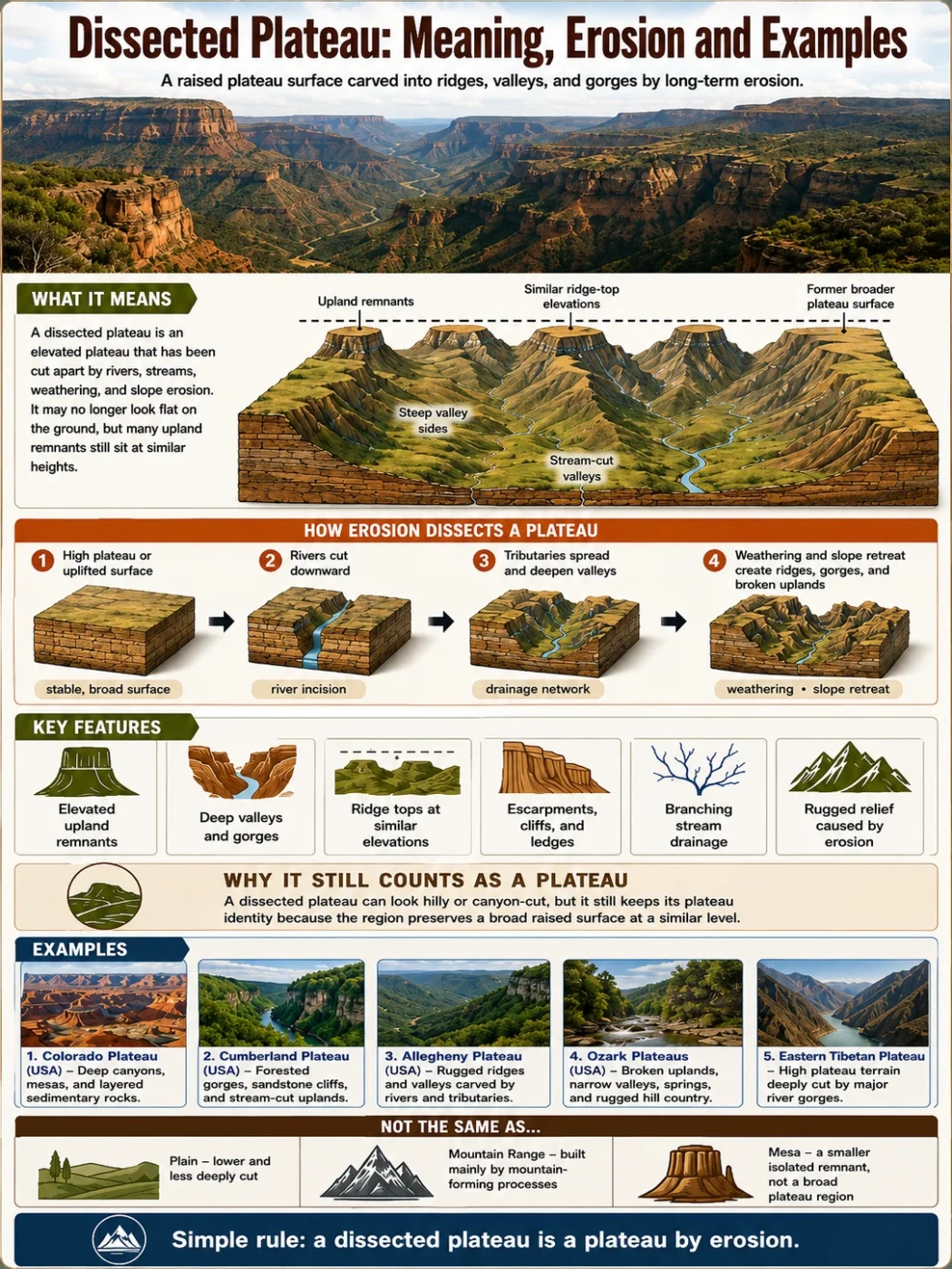
A dissected plateau is an elevated land surface that once had a broader, flatter summit area, but rivers, streams, weathering, and slope erosion have cut it into valleys, ridges, gorges, and broken uplands. It may still be a plateau in structure and elevation, even when it no longer looks like a smooth tableland on the ground.
A dissected plateau is not simply a plateau with a few valleys. It is a plateau where erosion has worked long enough to break the surface into a more rugged pattern. On a map, it may show a fairly even high-level surface. On the ground, it can feel like a region of hills, narrow valleys, ravines, cliffs, and stream-cut slopes.
This is why the term can confuse readers. The landform keeps its plateau identity because many ridge tops or upland remnants still sit near a similar elevation. But the surface between them has been deeply cut by running water, gravity, frost action, and long-term weathering.
| Feature | What It Means |
|---|---|
| Basic Meaning | An elevated plateau surface cut into valleys, ridges, gorges, and separated uplands by erosion. |
| Main Process | River erosion, stream incision, weathering, slope retreat, and valley widening. |
| Typical Shape | High ridges or upland remnants with steep valley sides and narrow drainage lines. |
| Common Rock Setting | Layered sedimentary rocks, resistant caprock, old uplifted surfaces, or high plateaus crossed by rivers. |
| Map Clue | Many valleys cutting into a raised region while nearby ridge tops remain at similar heights. |
| Good Examples | Parts of the Colorado Plateau, Cumberland Plateau, Allegheny Plateau, Ozark Plateaus, and eastern Tibetan Plateau. |
What Does Dissected Plateau Mean?
A dissected plateau is a high, broad landform that has been cut apart by erosion. The word “dissected” means the surface has been sliced into smaller pieces by natural processes, mainly water moving downhill through channels.
The original plateau surface may have been flatter, or at least more continuous, before erosion became strong. Over time, streams cut into weak zones, joints, rock layers, and slopes. Valleys deepened. Side slopes widened. The remaining uplands became ridges, benches, mesas, or high interfluves (the land between drainage lines).
Landform Note
A dissected plateau can still be a plateau even when the walking surface feels hilly. The clue is not perfect flatness. The clue is a raised region where many upper surfaces still share a broadly similar elevation.
In simple terms, a dissected plateau is a plateau that has been carved by erosion but not fully worn down into a low plain.
How Erosion Creates a Dissected Plateau
Dissection usually begins when a plateau is raised above nearby land or when rivers gain enough energy to cut downward. This can happen after tectonic uplift, regional tilting, a fall in base level, climate shifts, or the exposure of rock layers that erode at different speeds.
Once flowing water starts cutting into the surface, the process often follows a clear pattern:
- Uplift or high elevation gives rivers more slope. Water flows faster when it has more vertical drop.
- Streams cut channels into the plateau surface. Small valleys form first, then deepen over long periods.
- Tributaries join the main valleys. The drainage network spreads across the plateau.
- Weathering weakens exposed rock. Freeze-thaw action, chemical weathering, plant roots, and groundwater help break rock apart.
- Slopes retreat and valleys widen. The plateau surface becomes broken into ridges, spurs, benches, and isolated uplands.
The result is a landform that may look rugged, but still has a plateau pattern when viewed at regional scale.
Why Rivers Matter So Much
Rivers are the main sculptors of dissected plateaus. A river that cuts into a plateau does more than make one valley. Its tributaries spread across the surface like branches. Each branch removes rock and soil from a different part of the upland.
This is why dissected plateaus often show a dendritic drainage pattern, where streams look like the branches of a tree. That pattern is common where rocks are fairly uniform or where streams have developed across a broad raised surface.
Field Note
If a plateau is deeply dissected, the flattest places may be found on ridge tops, benches, or old upland remnants rather than across one continuous surface.
Formation: Uplift First, Cutting Later
Many dissected plateaus begin as broad elevated regions. Tectonic forces may lift a crustal block, or a region may stand high because of long-term geologic structure. After that, rivers and weathering reshape the surface.
The formation process can be read as two linked stages:
1. A Plateau Surface Develops or Rises
The land may be lifted by tectonic uplift, regional warping, or the slow rise of a crustal block. In other cases, a resistant rock layer protects a high surface while nearby softer rocks erode away. The surface does not need to be perfectly flat, but it must be broad and elevated compared with surrounding land.
2. Erosion Cuts the Plateau Into Relief
Once rivers gain energy, they cut down into the plateau. This creates relief: the vertical difference between valley bottoms and upland ridges. A plateau with low relief may feel open and rolling. A dissected plateau with high relief may feel like a rugged hill country.
Harder rock layers may form cliffs, ledges, or caprock-protected summits. Softer layers below may erode faster, steepening valley sides and creating slopes beneath resistant rims.
Careful wording: Not every rugged upland is a dissected plateau. The landform must still preserve a plateau-like regional surface, rock structure, or high-level pattern. Otherwise, it may be better described as hills, mountains, badlands, or an eroded highland.
Main Features of a Dissected Plateau
A dissected plateau can vary from gently cut uplands to deeply carved canyon country. Still, several features appear often.
| Feature | How It Appears | Why It Forms |
|---|---|---|
| Ridge Tops | Long, narrow high areas between valleys. | Streams cut down on both sides, leaving upland remnants. |
| Deep Valleys | V-shaped valleys, ravines, gorges, or canyons. | Rivers and streams incise into the plateau surface. |
| Escarpments | Steep edges or abrupt slopes along plateau margins. | Resistant rock layers form sharp breaks in slope. |
| Benches and Ledges | Step-like surfaces along valley sides. | Alternating hard and soft rock layers erode at different rates. |
| Gorges or Canyons | Deep, narrow cuts in the plateau. | Strong vertical river erosion cuts faster than valley widening. |
| Upland Remnants | Small flat or rolling areas left above valleys. | Parts of the old plateau surface remain between drainage lines. |
Elevation and Relief Are Not the Same
Elevation means height above sea level. Relief means the height difference between high and low points in the same area. This difference matters when reading a dissected plateau.
A plateau can have high elevation but low local relief if its surface is broad and smooth. A dissected plateau may have moderate elevation but strong local relief because valleys have cut deeply into it.
Elevation Note
Dissected plateaus are often described by both elevation and relief. Elevation tells how high the region sits. Relief tells how strongly erosion has cut the surface.
For example, a plateau edge may stand only a few hundred meters above nearby lowlands, but if streams cut steep ravines through it, the land can feel much more rugged than its elevation number suggests.
Climate and Landscape on Dissected Plateaus
Climate affects how a dissected plateau looks. Water, temperature change, vegetation, and rock type all shape the speed and style of erosion.
Humid Regions
In wetter climates, rivers and streams are usually more active. Valleys may be forested, slopes may be rounded, and soils can cover much of the bedrock. The Cumberland and Allegheny plateau regions show this kind of stream-cut upland pattern in many places.
Dry and Semi-Dry Regions
In drier regions, vegetation may be thinner and exposed rock may stand out more clearly. Erosion can create cliffs, canyons, mesas, buttes, and badland-like slopes. Parts of the Colorado Plateau show strong examples of river incision, canyon cutting, and resistant rock layers.
High Mountain Margins
On high plateaus near mountain belts, rivers may cut very deep valleys because they flow from high elevations toward lower basins. In places such as the eastern Tibetan Plateau, major rivers have carved deep gorges through high terrain, making the plateau surface harder to recognize from ground level.
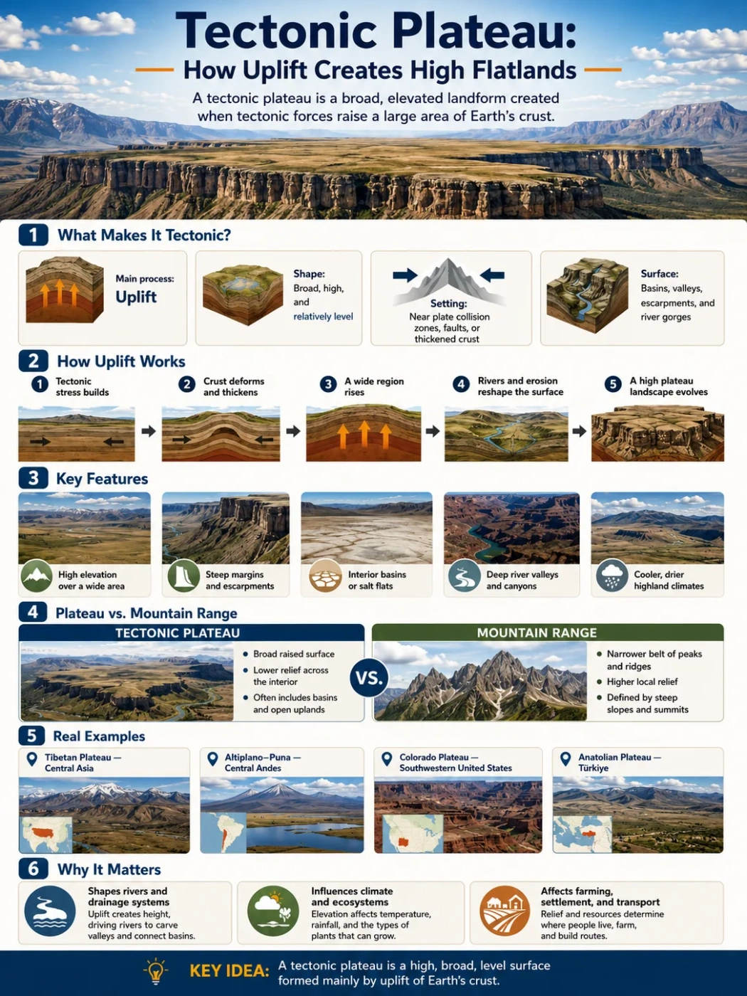
Dissected Plateau vs Other Landforms
A dissected plateau is easy to confuse with mountains, hills, mesas, and badlands. The difference is mostly about scale, structure, and how much of the older high surface remains.
| Landform | Main Shape | How It Differs From a Dissected Plateau |
|---|---|---|
| Plain | Low or gently rolling land with little relief. | A dissected plateau is elevated and cut by valleys, often with steeper slopes. |
| Mountain Range | High peaks, ridges, and strong relief. | A dissected plateau often has ridge tops that mark an older plateau surface rather than sharp peak-building processes. |
| Mesa | Isolated flat-topped hill or tableland. | A mesa can be a remnant of a dissected plateau, but it is smaller and more isolated. |
| Butte | Small, steep-sided isolated hill. | A butte is usually smaller than a mesa and much smaller than a plateau region. |
| Badlands | Soft rock or clay-rich terrain cut into many small gullies. | Badlands are defined more by intense surface erosion and weak materials than by a preserved high plateau surface. |
| Escarpment | Steep slope or long cliff-like edge. | An escarpment may form the edge of a plateau, but it is not the whole plateau. |
Common Mix-Up
A dissected plateau may be called “mountainous” in everyday speech because it looks rugged. In landform terms, the plateau label comes from the raised regional surface and geologic setting, not from whether the ground feels flat during travel.
How to Recognize a Dissected Plateau on a Map
A map often makes the landform easier to understand than a single ground-level view. Look for a raised area with many streams cutting into it.
Useful map-reading clues include:
- Closely spaced contour lines along valley sides, showing steep slopes.
- Ridge tops or upland surfaces that sit at broadly similar elevations.
- Branching drainage networks across the plateau surface.
- Deep valleys, gorges, or canyons crossing an elevated region.
- A sharp plateau margin or escarpment on one or more sides.
- Place names that include plateau, tableland, highland, ridge, gorge, canyon, or valley.
On shaded relief maps, dissected plateaus often appear as wrinkled or branching uplands. The highest surfaces may line up across the region, while the valleys cut down through them.
Map Note
When a dissected plateau is very deeply eroded, the original flatness may be hard to see. The pattern becomes clearer when comparing many ridge-top elevations across a wide area.
Examples of Dissected Plateaus
Dissected plateaus occur in many parts of the world. Some are famous for canyons and exposed rock. Others look like forested hill country but still belong to a plateau province.
| Example | Region | Why It Fits the Type | Notable Features |
|---|---|---|---|
| Colorado Plateau | Southwestern United States | Raised plateau country cut by rivers into canyons, mesas, cliffs, and basins. | Grand Canyon, Colorado River system, layered sedimentary rocks. |
| Cumberland Plateau | Appalachian region, United States | A plateau surface cut by headwater streams, gorges, ravines, and steep valley walls. | Cumberland and Tennessee River tributaries, sandstone cliffs, forested uplands. |
| Allegheny Plateau | Northeastern and Appalachian United States | Stream erosion has carved the plateau into ridges, valleys, and upland hill country. | Allegheny, Susquehanna, Delaware, and Ohio drainage systems. |
| Ozark Plateaus | Central United States | Uplifted sedimentary rock surfaces are cut by valleys, springs, rivers, and karst features. | Boston Mountains, limestone and dolomite areas, narrow valleys. |
| Eastern Tibetan Plateau | Central and East Asia | High plateau terrain is cut by major rivers into deep valleys and gorges. | Headwater regions linked to large Asian river systems. |
Colorado Plateau
The Colorado Plateau is one of the clearest large-scale examples of a plateau shaped by river incision. The region contains broad uplands, layered rocks, mesas, cliffs, and deep canyons. The Colorado River and its tributaries have cut into the plateau, exposing long rock sequences and creating some of the most recognizable canyon landscapes on Earth.
It is not “flat” in the everyday sense. It is a high plateau province where erosion has revealed the structure of the land.
Cumberland Plateau
The Cumberland Plateau forms part of the Appalachian Plateau region in the eastern United States. It is strongly cut by streams and tributaries, creating steep-sided valleys, gorges, sandstone bluffs, and forested uplands.
In many places, the land looks like hill country. Yet its geologic structure and regional position show its plateau character. The high surfaces and valley networks tell the story of long erosion across uplifted, layered rocks.
Allegheny Plateau
The Allegheny Plateau is another Appalachian example. Streams have cut the plateau into ridges and valleys, especially where rivers drain toward larger systems such as the Ohio, Susquehanna, Delaware, and Allegheny rivers.
This region helps show why dissected plateaus may be mistaken for mountains. The surface is rugged, but much of the form comes from erosion cutting into a plateau rather than from sharp, young mountain building.
Ozark Plateaus
The Ozark Plateaus show a different version of the landform. The region includes sedimentary rocks such as limestone, dolomite, sandstone, shale, and chert. Streams, springs, valleys, and karst processes have shaped much of the landscape.
The Boston Mountains are often described as a deeply dissected plateau within the southern Ozark region. Here, stream valleys and steep slopes break up the upland surface.
Eastern Tibetan Plateau
The Tibetan Plateau is usually known for its great elevation, but parts of its eastern side are strongly dissected by rivers. Several major Asian river systems begin in or near this high terrain and cut deep valleys as they flow away from the plateau interior.
This example is useful because it shows that a dissected plateau does not have to be low or old-looking. Even a very high plateau can be deeply cut where rivers have enough energy and long-term drainage routes.
Why Dissected Plateaus Matter in Geography
Dissected plateaus matter because they connect several parts of physical geography at once: uplift, erosion, rivers, rock resistance, climate, drainage basins, and human settlement.
They help explain why some regions have:
- Roads that wind through valleys instead of crossing straight over uplands.
- Towns and farms concentrated on valley floors, terraces, or gentler benches.
- Sharp changes in slope over short distances.
- Waterfalls or rapids where streams cross resistant rock layers.
- Thin soils on ridge tops and deeper soils in valley bottoms.
- Scenic overlooks where plateau remnants stand above eroded valleys.
These landscapes also shape river basins. A dissected plateau may feed many tributaries into a larger river system. The high ground controls drainage divides, while the valleys guide water, sediment, roads, and settlement.
Rocks, Caprock, and Valley Cutting
Rock type has a strong effect on how a plateau is dissected. Resistant sandstone, limestone, basalt, or hard caprock may protect parts of the surface. Softer shale, mudstone, clay-rich rock, or weathered material may erode more quickly underneath.
This difference can create step-like slopes. A hard layer forms a ledge or cliff. A softer layer below wears back into a gentler slope. Over time, the plateau edge retreats and valleys deepen.
Where rock layers are nearly horizontal, dissected plateaus may show flat benches and steep breaks. Where rocks are folded or faulted, erosion may follow structural weaknesses, creating a more complex pattern of ridges and valleys.
Avoid one-size-fits-all labels: A dissected plateau can form in sedimentary, volcanic, or mixed rock settings. The shared feature is not one rock type. It is the erosion of a raised plateau surface into a broken upland landscape.
Dissected Plateau and Human Life
Human use of dissected plateaus often follows the shape of the land. Valley bottoms may offer water access, deeper soils, flatter routes, and space for settlements. Ridge tops may be used for roads, grazing, forestry, wind exposure, or viewpoints, depending on the region.
Steep slopes can limit farming and construction. Narrow valleys can make transport harder. At the same time, dissected plateau regions may hold forests, minerals, springs, caves, waterfalls, and scenic landscapes.
In humid regions, these plateaus may support dense forest and many small streams. In dry regions, they may expose bare rock, canyon walls, and sparse vegetation. The human pattern changes with climate, soil, water, and access.
Common Misconceptions About Dissected Plateaus
A Dissected Plateau Is Not Always Flat
The word plateau often suggests a flat table. That can be misleading. A dissected plateau may have only small remnants of flat land left. Its plateau identity comes from the raised regional surface and shared upland level, not from a smooth walking surface everywhere.
It Is Not the Same as a Mountain Range
A mountain range usually forms through strong uplift, folding, faulting, volcanic activity, or related mountain-building processes. A dissected plateau may look mountainous, but much of its relief comes from rivers cutting down into an elevated surface.
It Is Not Just Any Eroded Land
All land erodes, but not all eroded land is a dissected plateau. The term fits best where a raised plateau surface has been cut into valleys and uplands while still preserving a plateau-scale pattern.
Simple Rule for Remembering the Term
Use this simple rule: a dissected plateau is a raised tableland that erosion has carved into pieces.
The “plateau” part tells the original or regional shape. The “dissected” part tells what erosion has done to it.
| Word Part | Meaning | Geographic Idea |
|---|---|---|
| Dissected | Cut into sections. | Rivers, streams, and erosion have divided the surface. |
| Plateau | Raised broad land surface. | The land sits higher than nearby areas and keeps a regional upland pattern. |
| Dissected Plateau | Raised land cut by erosion. | A plateau broken into ridges, valleys, gorges, and upland remnants. |
FAQ About Dissected Plateaus
What is a dissected plateau in simple words?
A dissected plateau is a raised land surface that has been cut by rivers and erosion into valleys, ridges, gorges, and smaller upland areas. It may no longer look flat, but it still keeps a plateau-like regional pattern.
How does a dissected plateau form?
It usually forms when a plateau is uplifted or stands high above nearby land, then rivers and streams cut into it over long periods. Weathering, slope erosion, and differences in rock resistance help deepen valleys and break the surface apart.
Is a dissected plateau the same as a mountain?
No. A dissected plateau can look mountainous because it has steep valleys and ridges, but its shape often comes from erosion cutting into an elevated plateau surface. A mountain range is usually linked more directly to peak-building processes such as folding, faulting, volcanism, or strong crustal uplift.
Why do some dissected plateaus have canyons?
Canyons form where rivers cut downward faster than the valley sides widen. This often happens in raised regions with resistant rock layers, dry or semi-dry climates, or rivers with enough energy to incise deeply into the plateau.
What are examples of dissected plateaus?
Common examples include parts of the Colorado Plateau, Cumberland Plateau, Allegheny Plateau, Ozark Plateaus, and eastern Tibetan Plateau. Each has raised terrain that has been cut by rivers, streams, and long-term erosion.
How can a plateau still be a plateau if it is not flat?
A plateau does not have to be flat everywhere. In a dissected plateau, the old surface may survive only as ridge tops, benches, or upland remnants. The broader region can still be recognized as a plateau because many high surfaces share a similar elevation and geologic setting.