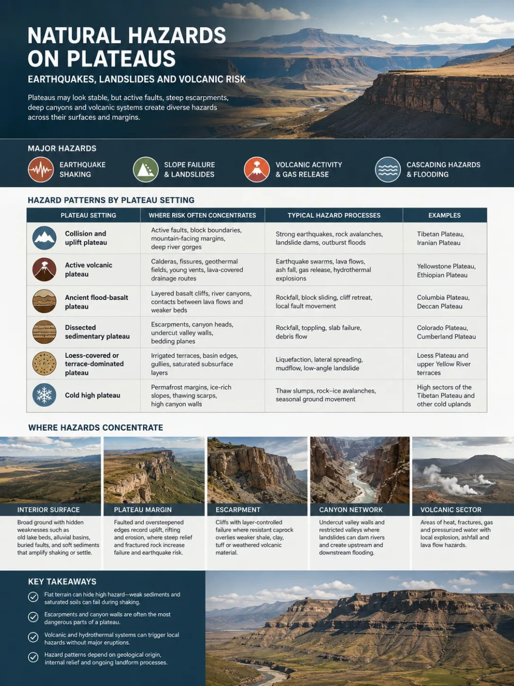
Plateau Hazards and Landscape Processes
A plateau may present a broad, level skyline while active faults, unstable escarpments, deep river canyons, weak sediment basins, and volcanic systems remain hidden within or beneath the landform. The real hazard pattern depends on how the plateau formed, where erosion has cut into it, and how water, rock structure, ice, and human land use interact.
A plateau is not a single uniform surface. Its interior plains, sediment-filled basins, canyon walls, escarpments, fault zones, and volcanic sectors can respond very differently to the same event. A strong earthquake may cause little slope movement on exposed bedrock yet trigger liquefaction in a nearby terrace. Heavy rain may leave the plateau top intact while canyon walls fail below it. An active hydrothermal field may produce a local explosion without a magmatic eruption.
Flat terrain is not the same as low hazard. Gentle slopes can contain saturated loess, lake sediment, volcanic ash, or river deposits that lose strength during shaking. The steepest danger may also sit below the apparent plateau surface, along an escarpment or deeply cut valley.
How Hazard Patterns Differ Across Plateau Settings
Natural hazards on plateaus follow the geology of the landform. A collision plateau, an old lava plateau, a dissected sedimentary plateau, and an active volcanic plateau should not be assessed in the same way.
| Plateau Setting | Where Risk Often Concentrates | Typical Hazard Processes | Representative Examples |
|---|---|---|---|
| Collision and uplift plateau | Active faults, block boundaries, mountain-facing margins, deep river gorges | Strong earthquakes, rock avalanches, landslide dams, outburst floods | Tibetan Plateau, Iranian Plateau |
| Active volcanic plateau | Calderas, fissures, geothermal fields, young vents, lava-covered drainage routes | Earthquake swarms, lava flows, ash fall, gas release, hydrothermal explosions | Yellowstone Plateau, parts of the Ethiopian Plateau |
| Ancient flood-basalt plateau | Layered basalt cliffs, river canyons, contacts between lava flows and weaker beds | Rockfall, block sliding, cliff retreat, local fault movement | Columbia Plateau, Deccan Plateau |
| Dissected sedimentary plateau | Escarpments, canyon heads, undercut valley walls, bedding planes | Rockfall, toppling, slab failure, debris flow | Colorado Plateau, Cumberland Plateau |
| Loess-covered or terrace-dominated plateau | Irrigated terraces, basin edges, gullies, saturated subsurface layers | Liquefaction, lateral spreading, mudflow, low-angle landslide | Loess Plateau and upper Yellow River terraces |
| Cold high plateau | Permafrost margins, ice-rich slopes, thawing scarps, high canyon walls | Thaw slumps, rock-ice avalanches, seasonal ground movement | High sectors of the Tibetan Plateau and other cold uplands |
Landform Note
The name plateau describes an elevated surface, not one fixed rock type or tectonic condition. Hazard assessment must begin with the plateau’s geological origin and internal relief rather than its outline on a small-scale map.
Where Risk Concentrates Within a Plateau
The broad upper surface often receives the most attention, yet the most active terrain commonly lies at transitions: where hard rock meets weak sediment, where a river cuts through the plateau, or where a fault separates crustal blocks.
Interior Surface
Broad Ground With Hidden Weaknesses
Plateau interiors may contain old lake beds, alluvial basins, buried faults, volcanic deposits, or shallow groundwater. These conditions can increase shaking, settlement, fissuring, and liquefaction even where the slope is slight.
Plateau Margin
Faulted and Oversteepened Edges
Margins may record uplift, rifting, erosion, or crustal block movement. Fault scarps, steep relief, fractured rock, and roads cut into slopes often occur in the same narrow belt.
Escarpment
Cliffs With Layer-Controlled Failure
A resistant caprock can rest above shale, clay, tuff, or weathered volcanic material. Failure in the weaker layer may release large slabs from the stronger rock above.
Canyon Network
Undercut Walls and Restricted Valleys
River incision removes support from slopes. A landslide entering a narrow gorge can block the channel and create a temporary lake, extending the hazard far upstream and downstream.
Volcanic Sector
Heat, Fractures, Gas, and Pressurized Water
Young lava fields, calderas, fissures, and geothermal basins may host earthquake swarms, deformation, steam-driven blasts, gas release, or renewed eruption.
Why Earthquakes Occur Beneath Plateaus
Plateaus form through several processes, and each process leaves a different fault pattern. Some rise as continents collide. Others develop above hot mantle, broad volcanic provinces, rifts, or crustal blocks that move vertically. Even a plateau with an old surface can contain younger active faults.
Collision Can Produce Both Compression and Extension
The Tibetan Plateau formed within the broad collision zone between the Indian and Eurasian plates. Compression thickened and raised the crust, but the elevated interior does not deform only through thrust faulting. Parts of the plateau also stretch sideways, producing normal faults within a region created by continental collision.
The 7 January 2025 southern Tibetan Plateau earthquake showed this clearly. The magnitude 7.1 event occurred at shallow depth through normal faulting north of the main plate boundary. Its mechanism is a useful reminder that a high collision plateau may contain both compressional structures and extensional faults.
Strike-Slip Faults Divide Plateau Blocks
Some high plateaus behave as a group of crustal blocks rather than one rigid slab. Long strike-slip faults allow these blocks to move sideways past one another. The main fault may branch into smaller segments, cross basins, follow valleys, or pass beneath sediment that hides its surface trace.
A quiet-looking interior can therefore remain seismically active. Surface shape alone does not show the full fault network.
Old Faults Can Move Again
Faults formed during an older phase of uplift or rifting can be reactivated when regional stress changes. Magma movement, nearby earthquakes, erosion, sediment loading, or water pressure in fractured rock may also alter local stress. Reactivation does not mean every old fault is dangerous; it means geological age alone cannot be used as proof of stability.
Why Shaking Varies Across the Same Plateau
Earthquake magnitude and distance matter, but local ground conditions can change how the shaking is felt. Two locations on the same plateau may experience different motion because one sits on hard bedrock and the other on a deep sediment basin.
Sediment Basins Can Amplify and Prolong Motion
Loose river deposits, lake sediment, volcanic ash, and basin fill often transmit seismic waves differently from hard rock. Thick sediment can amplify particular frequencies and lengthen shaking. This matters for towns, roads, dams, and industrial sites built on broad interior basins that look safer than the surrounding escarpments.
Water-saturated sand and silt may also lose strength through liquefaction. The ground can settle, spread sideways, crack, or flow toward a river channel even when the surface gradient is very low.
Ridges and Escarpment Crests May Focus Shaking
Sharp topography can focus seismic energy. Narrow ridges, canyon rims, and the upper edges of escarpments may shake more strongly than nearby lower ground at some frequencies. This effect is called topographic amplification.
Structures placed on prominent edges—communication towers, viewpoints, roads, pipelines, and power lines—can therefore face a combined problem: stronger local motion and less stable fractured rock.
Surface Rupture Can Cross Level Ground
A fault rupture on a plateau interior may not create a landslide, yet it can offset the systems that depend on a continuous surface. Roads, airfields, canals, fences, buried cables, and pipelines may be displaced vertically or sideways. A small change in gradient can also redirect irrigation water or create temporary ponding across agricultural land.
Earthquake hazard is not limited to the mapped fault line. Shaking, liquefaction, rockfall, landslide runout, and river blockage can affect areas far beyond the rupture itself.
Why Plateau Landslides Are More Varied Than They Appear
The word landslide covers several kinds of movement. Plateau terrain can produce falling blocks, sliding slabs, rotating masses, slow deep deformation, fast debris flows, and liquefied sediment flows. The failure type depends on slope shape, rock layering, water, weathering, and the trigger.
Escarpment Failure Follows Rock Structure
Plateau escarpments often expose stacked rock layers. Basalt, limestone, or sandstone may form a strong upper cliff, while shale, clay, paleosol, volcanic tuff, or weathered rock lies below. Water entering joints can weaken the lower layer or reduce friction along a bedding plane.
The resulting movement may take several forms:
- Rockfall: individual blocks detach from a cliff or canyon wall.
- Toppling: tall columns rotate outward along joints.
- Translational sliding: a slab moves along a bedding plane or weak contact.
- Rotational sliding: soil or weak rock moves along a curved failure surface.
- Rock avalanche: a large fractured mass travels rapidly and may run far beyond the source slope.
River Incision Creates Failure Zones Below the Plateau Top
Rivers cut downward as plateaus rise or as drainage systems adjust. This process creates deep canyons and removes support from valley walls. A slope may remain stable for a long period, then fail after undercutting, heavy rain, snowmelt, freeze–thaw weathering, or earthquake shaking.
Canyon landslides are especially important because the moving mass can enter a restricted channel. The danger then changes from a slope problem into a river-basin problem.
Gentle Terraces Can Produce Long-Runout Flows
One of the most easily missed plateau hazards occurs on broad river terraces and loess surfaces. A low slope does not prevent movement when saturated sediment loses strength.
During the 18 December 2023 Jishishan earthquake, a landslide-mudflow developed on a Yellow River terrace with a slope of less than about 3 degrees. The material traveled roughly 2.8 kilometres across agricultural terrain. Research linked the event to liquefaction within saturated layers, the terrace’s internal stratigraphy, active tectonics, and long-term irrigation.
This case changes the way low-angle plateau terrain should be read. Slope maps alone can miss danger where water, buried sand, loess, frozen surface layers, and shaking combine.
Field Note
Look beyond the steepness of the surface. Cracks, sagging ground, old flow lobes, tilted walls, displaced channels, wet zones, and abrupt vegetation changes may reveal earlier movement or unstable subsurface conditions.
Water Can Be a Trigger, a Lubricant, or an Added Load
Rain and snowmelt increase pore-water pressure inside soil and fractures. Irrigation can raise groundwater over many years. Reservoir filling and rapid drawdown can change pressure along valley slopes. In volcanic terrain, hot water can alter rock into weak clay-rich material.
The same plateau may therefore have different landslide seasons. Monsoon rain may control one margin, spring thaw another, and irrigation-related saturation an interior terrace.
Permafrost Thaw Changes High Plateau Slopes
In cold highlands, frozen ground can hold fractured rock and ice-rich sediment together. Warming, deeper seasonal thaw, and meltwater infiltration may weaken that support. Possible results include active-layer detachments, thaw slumps, rock-ice avalanches, and slow ground deformation.
Freeze–thaw cycles also widen cracks. Water freezes, expands, and helps detach blocks from canyon walls or escarpments. The process can continue even where no single storm or earthquake provides an obvious trigger.
Roads and Excavation Can Expose Existing Weakness
Road cuts, quarries, mines, drainage ditches, and construction pads change slope shape and water movement. A cut may remove support from the base of a layered cliff. A blocked drain can concentrate water into weathered rock. These activities usually work with existing geological weakness rather than creating the entire problem from nothing.
Volcanic Risk Depends on the Age and Type of Plateau
A volcanic plateau may be an ancient lava province, an active caldera region, a field of scattered vents, or a broad highland shaped by repeated eruptions and later erosion. These settings do not share one level of present-day volcanic activity.
Ancient Lava Plateaus Are Not Automatically Active Volcanic Systems
The Columbia River Basalt Group formed through more than 350 mapped lava flows erupted from long fissures between about 16.7 and 5.5 million years ago. The preserved basalt province covers more than 210,000 square kilometres. Its volcanic origin explains the stacked lava layers and broad plateau surface, but it does not make the whole province an active eruption zone today.
Modern hazards there often relate more directly to layered basalt cliffs, joints, faults, canyon incision, weak sediment between flows, and nearby younger volcanic centres than to renewed flood-basalt eruptions across the entire plateau.
Active Plateaus May Have Several Volcanic Sources
An active volcanic plateau may contain more than one vent or cone. Magma can rise beneath fissures, calderas, lava domes, or scattered volcanic fields. Hazard distance must therefore be measured from the active source and expected flow path, not from the edge of the named plateau.
Topography controls where lava, lahars, and dense debris flows travel. Wind controls the path of ash. Gas may collect in low areas. Snow and ice can add water to volcanic debris and create fast-moving flows along valleys.
Hydrothermal Explosions Do Not Require Magma at the Surface
In geothermal areas, groundwater may be heated under pressure. If the pressure falls suddenly, part of the water flashes into steam and expands. The blast can throw hot water, mud, and rock outward and leave a crater. This is a hydrothermal explosion, not necessarily a magmatic eruption.
On 23 July 2024, a hydrothermal explosion at Black Diamond Pool in Yellowstone’s Biscuit Basin threw mud, water, and rocks into the air and damaged a boardwalk. Later field work showed that the debris came from shallow sediment and glacial material rather than deep rhyolite bedrock. The event showed how a local steam-driven hazard can occur within an active volcanic plateau without a change to a large eruptive state.
| Volcanic Process | Main Control on Impact Area | Typical Plateau Effect | Common Misreading |
|---|---|---|---|
| Fissure-fed lava flow | Vent position, lava volume, slope, valleys, barriers | Road burial, drainage change, local isolation, fire and heat near the flow | Assuming lava spreads evenly across the whole plateau |
| Ash-producing eruption | Wind direction, plume height, eruption duration | Reduced visibility, water contamination, transport interruption, crop and machinery damage | Using distance from the vent as the only measure |
| Lahar or volcanic debris flow | Water supply, loose volcanic sediment, valley network | Fast movement along river corridors and low ground | Treating a distant valley as protected because it is outside the crater area |
| Hydrothermal explosion | Pressurized hot-water system and shallow fractures | Very local blast, crater formation, rock and hot-water ejection | Calling every steam-driven blast a magma eruption |
| Volcanic earthquake swarm | Magma, fluid movement, active faults | Repeated local shaking and possible slope disturbance | Assuming every swarm must lead to an eruption |
Common Mix-Up
Volcanic origin describes how a plateau formed. Active volcanic hazard describes what its present subsurface system can do. An old flood-basalt plateau and a young caldera plateau should not be placed in the same risk category merely because both contain lava rock.
How One Hazard Becomes a Chain of Hazards
The most damaging plateau events often involve a sequence rather than one isolated process. Relief, narrow valleys, weak sediment, and restricted transport routes allow one event to create the conditions for another.
Ground or Slope Disturbance
An earthquake, intense rain, rapid thaw, volcanic activity, or river undercutting reduces the strength of rock or sediment.
Mass Movement Begins
Rock, soil, ice, or liquefied sediment moves from an escarpment, canyon wall, terrace, or volcanic slope.
The Valley Becomes a Path or Barrier
The moving mass may follow a channel, cross a terrace, strike infrastructure, or block a river.
Water Extends the Hazard
A landslide dam stores water upstream. Overtopping or dam failure can release an outburst flood far from the original slope.
Later Triggers Reactivate Damaged Ground
Aftershocks, rain, snowmelt, changing lake levels, and erosion can move slopes that survived the first event.
Earthquake to Landslide
Moderate and large earthquakes can release rockfalls, shallow soil slides, deep rock avalanches, and liquefaction flows. Weakly cemented rock, fractured bedrock, loess, volcanic soil, alluvium, and artificial fill are among the materials that may respond poorly to strong shaking.
Landslide to River Blockage
When a landslide enters a narrow plateau gorge, it can form a natural dam. Water then rises behind the blockage, floods upstream land, and places pressure on the unstable barrier. If the dam fails, the outburst can carry sediment and debris far downstream.
Water Loading to Local Seismicity
The relationship can also run in the other direction. In 2018, two large landslides at Baige on the Tibetan Plateau blocked the Jinsha River. Research found that the changing water load and pore pressure around the landslide-dammed lakes were linked with a local rise in small earthquakes. The case shows that a hazard chain can feed back into the crust rather than moving only from earthquake to landslide.
Volcanic Heat to Meltwater and Debris Flow
Where a volcanic plateau carries seasonal snow, glaciers, or frozen ground, hot ejecta and lava can release water quickly. Water mixes with ash and loose rock, then moves through valleys as a lahar or debris flow. The source may be high on the plateau while the strongest flow effects occur far below along a river corridor.
Earthquake Damage to Delayed Rainfall Failure
Not every unstable slope falls during the main shock. Shaking can open cracks, loosen blocks, and reduce internal strength. Later rain or snowmelt may then trigger movement days, months, or longer after the earthquake. Post-earthquake hazard maps need to be updated as weather and slope conditions change.
Four Events That Show Different Plateau Hazard Mechanisms
| Event | Plateau Setting | Primary Process | What It Reveals |
|---|---|---|---|
| Southern Tibetan Plateau earthquake, 2025 | High collision plateau with internal extension | Shallow normal-fault earthquake | Collision plateaus can contain extensional faults within their elevated interiors. |
| Jishishan landslide-mudflow, 2023 | Upper Yellow River terrace near the Tibetan–Loess Plateau transition | Earthquake-triggered liquefaction and low-angle flow | Very gentle terrain can produce long-runout movement when saturated layers fail. |
| Biscuit Basin explosion, 2024 | Active volcanic and hydrothermal plateau | Shallow steam-driven explosion | A local hydrothermal blast can occur without a magmatic eruption. |
| Baige landslide-dam cascade, 2018 | Deep river gorge on the Tibetan Plateau | Landslide, river blockage, lake loading, outburst flooding | Plateau hazards can form linked systems with effects upstream, downstream, and within nearby faults. |
Why Infrastructure Can Be More Exposed Than the Plateau Surface
Settlements may occupy broad, moderate-slope ground while the roads, power lines, canals, and pipelines that serve them cross much steeper terrain. A plateau community can avoid direct structural damage yet become isolated when a canyon road closes or a bridge approach fails.
Transport Routes Follow the Weakest Passages
Roads and railways commonly descend through escarpments, follow river valleys, or cross faulted mountain margins. These routes occupy the same corridors used by rockfall, debris flow, floodwater, and landslide runout.
Water Systems Depend on Stable Gradients
Canals, reservoirs, hydropower channels, and pipelines rely on controlled slopes. Surface rupture, settlement, or a landslide can change drainage direction, block an intake, damage a tunnel portal, or send sediment into a reservoir.
Plateau Edges Carry Linear Infrastructure
Transmission lines, communication links, and regional roads often follow ridges or escarpment rims because these routes are direct and remain above floodplains. Yet ridge-top amplification, cliff retreat, and rockfall can make the edge more exposed during earthquakes and storms.
Volcanic Areas Add Access and Monitoring Problems
Thermal basins, lava fields, and ash-prone areas may require temporary closure even when nearby towns are not threatened. Damage to a short road, bridge, or boardwalk can remove access to a much larger part of the landscape.
Exposure is a network problem. Plateau hazard studies should map not only buildings but also the narrow routes that connect water, energy, transport, emergency services, and isolated settlements.
How Plateau Hazards Are Mapped
No single map can represent every plateau hazard. Fault location, shaking, slope failure, runout, volcanic processes, and infrastructure exposure require different datasets and scales.
Earthquake Mapping
- Active fault maps show known surface traces and fault zones.
- Earthquake catalogues reveal where seismicity clusters through time.
- GPS and satellite radar measure slow crustal movement and ground deformation.
- Ground-motion models estimate expected shaking from possible earthquakes.
- Site-response maps identify sediment basins and soft ground that may amplify motion.
- Liquefaction maps combine soil type, groundwater, and expected shaking.
A fault map should not be read as a thin line separating danger from safety. Fault location can be uncertain, rupture may branch, and secondary effects extend beyond the mapped trace.
Landslide Mapping
- Terrain models show slope, curvature, drainage, scarps, and possible runout paths.
- LiDAR can reveal old landslide surfaces beneath vegetation.
- Geological maps identify weak layers, bedding direction, joints, faults, and weathered rock.
- Rain, snow, and groundwater records help explain when slopes may reach failure conditions.
- Satellite radar can detect slow movement before rapid collapse in some settings.
- Field inventories record old failures and provide evidence of how far material traveled.
A useful landslide map must consider both the source area and the runout area. The place where movement begins may be far above a road, village, river, or terrace reached by the debris.
Volcanic and Hydrothermal Mapping
- Seismic networks detect earthquakes linked with faults, magma, and fluid movement.
- Ground-deformation measurements track uplift, subsidence, and changing pressure.
- Gas and water chemistry can show changes in a volcanic or geothermal system.
- Thermal observations locate heat anomalies and changes in surface activity.
- Past lava, ash, and lahar deposits show where earlier events traveled.
- Valley and wind models estimate possible flow routes and ash dispersal.
Data Note
Hazard maps are models based on available terrain, geology, event history, and monitoring. They are not permanent boundaries. New erosion, land use, earthquakes, groundwater change, or volcanic activity can alter the pattern.
Common Misreadings of Plateau Hazard
“A Flat Surface Cannot Slide”
Liquefaction and lateral spreading can move saturated sediment across very gentle terrain. Low-angle river terraces deserve separate assessment where loess, sand layers, irrigation, and earthquake shaking occur together.
“The Plateau Interior Is Safer Than Its Edge”
This may be true for some bedrock surfaces, but not as a universal rule. Interior basins can amplify shaking, buried faults can cross level ground, and volcanic or hydrothermal systems may sit near the centre of a plateau.
“A Volcanic Plateau Is an Active Volcano”
Many lava plateaus formed millions of years ago. Their present hazard may come mainly from cliffs, canyon erosion, faults, or nearby younger volcanoes. The age and activity of each volcanic system must be checked separately.
“The Largest Possible Eruption Is the Main Current Threat”
At active volcanic plateaus, smaller events may be more relevant to everyday land management. Local earthquakes, hydrothermal explosions, gas release, ground deformation, lava flows, and ash-producing eruptions have different likelihoods and footprints.
“The Event Ends When the Shaking Stops”
Aftershocks, rain, snowmelt, river erosion, and changing water levels can reactivate damaged slopes. Landslide dams may fail later. Sediment can continue moving through the river system long after the original earthquake.
“One Hazard Map Shows the Whole Risk”
An earthquake map does not show every runout route. A landslide susceptibility map may omit liquefaction. A volcanic hazard map may focus on eruptions but not local hydrothermal blasts. Plateau risk is best read as a set of overlapping layers.
Questions That Define a Plateau’s Real Hazard Profile
- Did the plateau form through continental collision, rifting, volcanism, broad uplift, erosion, or more than one process?
- Do active faults cross the interior, follow the margins, or lie beneath sediment-filled basins?
- Are towns and transport routes built on bedrock, river deposits, lake sediment, volcanic ash, loess, or artificial fill?
- Where are the main escarpments, canyon walls, fault scarps, and undercut river bends?
- Does strong caprock rest above clay, shale, tuff, paleosol, or another weak layer?
- Are there mapped old landslides, sagging slopes, blocked valleys, or abandoned river channels?
- Could a slope failure block a river and create a temporary lake?
- Does irrigation, reservoir operation, snowmelt, or groundwater raise pore pressure in weak sediment?
- Is permafrost, ground ice, or seasonal freezing part of the slope system?
- Is volcanic activity ancient, dormant, geothermal, or linked with a monitored active magma system?
- Do hazard maps include both the source zone and the likely runout or inundation zone?
- Which roads, bridges, canals, pipelines, power lines, and communication routes cross the narrowest hazard corridors?