INTERACTIVE CONTEXT MAP
Where is Cumberland Plateau?
The selected plateau and nearby mapped locations are shown. Open the full world atlas to explore every region.
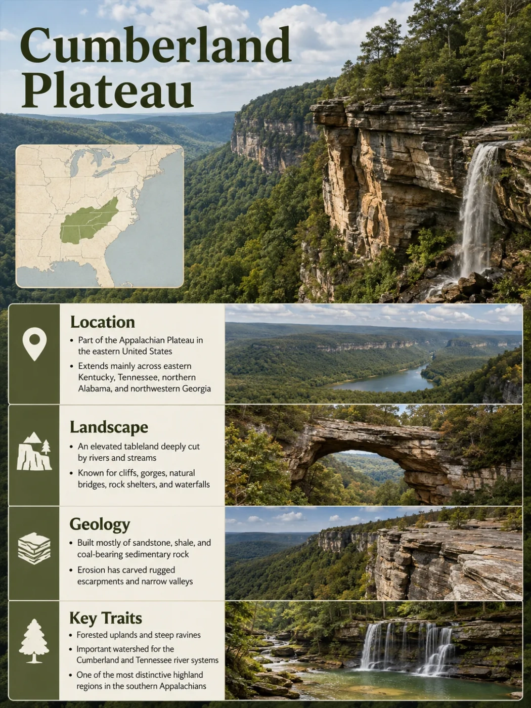
The Cumberland Plateau is a broad, elevated part of the southern Appalachian region whose surface has been cut so deeply by rivers that much of it looks mountainous from the ground. Sandstone-capped uplands, narrow forested ridges, steep escarpments, branching stream valleys and deep gorges define the landscape across eastern Kentucky, Tennessee and northern Alabama, with a smaller continuation into northwestern Georgia.
Where the Cumberland Plateau Is Located
The Cumberland Plateau belongs to the Appalachian Plateaus physiographic province of the eastern United States. It forms the southern part of a much larger system of relatively flat-lying sedimentary rocks that extends along the western side of the Appalachian Mountains.
The name is used most prominently for plateau terrain in eastern Kentucky and Tennessee, continuing southward into northern Alabama and a small part of northwestern Georgia. Its eastern side lies beside the folded terrain of the Valley and Ridge province, while lower uplands such as the Highland Rim occur along much of its western side in Tennessee.
Highland Rim and other lower interior uplands
Elevated sedimentary upland of the Appalachian Plateaus
Valley and Ridge and related Appalachian terrain
Boundary Note
The Cumberland Plateau is a physiographic region, not an administrative region. Its limits follow changes in landform, rock structure and relief rather than state borders. Different physiographic schemes also divide parts of the northern plateau differently, so a single state-by-state outline can imply more precision than the landscape supports.
Why a Plateau Can Look Like Mountain Country
The name “plateau” can be misleading if it suggests an unbroken flat tableland. Parts of the Cumberland Plateau retain broad or gently rolling upland surfaces, but rivers and tributaries have cut deeply into much of the region. The remaining high ground is often separated into ridges by narrow valleys and ravines.
Eastern Kentucky shows this especially well. There, sequences of nearly flat-lying Pennsylvanian rocks have been dissected into wooded crests, steep slopes and winding valleys. From many viewpoints, ridge after ridge appears on the horizon, producing the visual impression of a mountain range even though much of the relief developed by erosion cutting downward into an elevated rock surface.
Nearly horizontal sedimentary layers form an extensive upland.
Tributaries cut downward and expand across the surface.
Ravines and gorges separate parts of the former continuous upland.
High remnants preserve the regional plateau level while lower ground becomes increasingly rugged.
This distinction explains one of the Cumberland Plateau’s most recognizable patterns: rugged local relief within a larger plateau landform. The region does not need to remain flat everywhere to retain its plateau identity.
The Rock Layers Behind the Cumberland Landscape
The visible form of the Cumberland Plateau is closely tied to its layered sedimentary geology. Across large parts of the region, the upper landscape is developed on Pennsylvanian-age sandstone and shale, accompanied by siltstone, conglomerate and coal-bearing beds. These strata were deposited roughly 300 million years ago in changing river, delta, coastal and swamp environments.
The beds are commonly horizontal or only gently inclined. Resistant sandstone units tend to hold up plateau surfaces, ridge crests and cliff lines. Shale and other less resistant beds weather and erode more readily, helping produce slopes beneath the harder ledges.
Pennsylvanian sandstone, shale, conglomerate, siltstone and coal-bearing beds
Mississippian shale, sandstone and impure limestone units
Thicker limestone units exposed around some valleys, coves and plateau margins
This vertical sequence helps explain why the plateau can contain sandstone cliffs above slopes and limestone-related springs or caves at lower levels. The landforms are not randomly distributed; many follow the position and resistance of particular rock layers.
Escarpments Mark Some of the Plateau’s Sharpest Edges
One of the clearest ways to recognize the Cumberland Plateau is by its escarpments: steep breaks in elevation where resistant plateau rocks stand above neighboring lower terrain.
In Kentucky, the western margin is marked by the Pottsville, or Cumberland, Escarpment. Resistant Lower Pennsylvanian sandstone and conglomerate help maintain this prominent boundary between the Cumberland Plateau and lower terrain to the west. Streams cut backward into the escarpment, so its edge is irregular rather than a simple straight wall.
In Tennessee, prominent escarpments separate much of the plateau from the Highland Rim on the west and the Valley and Ridge region on the east. A general plateau elevation of about 600 metres, or roughly 2,000 feet, has been used for parts of Tennessee, with escarpment drops of around 300 metres in some areas. These values describe a broad regional pattern rather than a single elevation for the entire Cumberland Plateau.
Elevation Is Not Uniform
There is no useful single elevation that represents the entire Cumberland Plateau. Local plateau surfaces, river valleys, southern sections and strongly dissected areas occur at very different heights. Elevation figures are most reliable when tied to a specific part of the plateau rather than treated as a region-wide average.
Rivers Have Cut the Plateau Into a Branching Network of Valleys
Water is the main sculptor of the modern Cumberland Plateau. Much of its drainage has a dendritic pattern: small channels join larger tributaries in branching networks that resemble the limbs of a tree.
This pattern develops especially well where sedimentary rocks remain broadly horizontal and streams are not forced to follow a single dominant fold or fault direction. In eastern Kentucky, dendritic drainage is one of the defining features of Cumberland Plateau topography. The Cumberland River and related drainage systems cut between steep slopes and narrow ridges, while local valley bottoms provide some of the region’s broadest low ground.
Farther south, the same process produces some of the plateau’s deepest gorges. The Big South Fork of the Cumberland River and the Obed River system cut through resistant sandstone layers, exposing long cliff lines and steep V-shaped valleys.
Streams cut downward into the elevated sedimentary sequence, increasing local relief.
Smaller valleys grow headward into the upland and divide the surface into narrower ridges.
Weathering, rockfall and runoff widen valleys while resistant beds continue to form ledges and rims.
Why Cliffs, Rock Shelters, Arches and Waterfalls Are Common
Many of the Cumberland Plateau’s smaller landforms result from differential erosion. Thick sandstone layers resist weathering better than adjoining shale and weaker sedimentary beds. When a softer layer retreats beneath resistant rock, the harder bed can remain as a cliff, ledge or overhang.
Joints and fractures divide the sandstone into blocks. Weathering enlarges those openings, while rockfall removes unsupported sections. Over time, this combination can produce cliffs, natural arches, rock shelters, chimneys and large detached boulders. These forms are especially well developed in the deeply incised landscapes of the Big South Fork and Obed areas.
Waterfalls commonly occur where streams cross resistant sandstone ledges or where erosion has created an abrupt break in the channel profile. The same layered geology that preserves cliff-forming rock therefore helps create many of the region’s cascades and vertical drops.
Karst Lies Beneath Parts of the Sandstone-Capped Plateau
The Cumberland Plateau should not be treated as a uniformly karstic plateau. Its principal upper cap consists largely of sandstone, shale and conglomerate, which do not dissolve in the same way as limestone.
However, thick Mississippian limestones occur beneath the siliciclastic caprock. Where erosion exposes these carbonate rocks around escarpments, coves and deeply cut valleys, groundwater can enlarge fractures and create caves, springs, sinking drainage and other karst features. Tennessee studies describe a distinctive karst region along the Cumberland Plateau Escarpment and around the Sequatchie Valley.
Surface and Subsurface Can Behave Differently
A sandstone-covered plateau top may carry normal surface streams while exposed limestone lower on the slope supports underground drainage. The boundary between non-karst caprock and soluble limestone is therefore an important control on springs, caves and groundwater movement around parts of the plateau margin.
Groundwater can also move through fractures and bedding planes in the sandstone sequence. Where less permeable shale interrupts downward movement, water may travel laterally and emerge as springs along steep valley walls or escarpments.
Sequatchie Valley Breaks the Southern Plateau Into Separate Uplands
The Cumberland Plateau is not one continuous slab in Tennessee and northern Alabama. One of its most prominent internal breaks is the Sequatchie Valley, a long northeast-southwest-trending structural valley bordered by steep uplands.
The valley follows folded and faulted rocks and sits hundreds of feet below adjacent plateau surfaces. In parts of southern Tennessee, physiographic descriptions divide the broader plateau region into uplands separated by the Sequatchie and Wills valleys. Local names such as Walden Ridge and Lookout Mountain are applied to some of these high blocks.
This is an important reason the Cumberland Plateau can appear on maps as a mixture of plateaus, ridges, mountains and long valleys rather than a single rectangular upland.
Classification Detail
Physiographic classifications do not always treat the Sequatchie Valley in exactly the same way. Some regional schemes include it within the Cumberland Plateau section even though its folded carbonate rocks, low elevation and valley form differ strongly from the neighboring sandstone-capped uplands.
The Landscape Changes From Kentucky to Alabama
The Cumberland Plateau keeps a shared geologic and physiographic identity across the southern Appalachians, but its surface does not look the same everywhere. Degree of dissection, rock exposure and local structural geology change along its length.
| Area | Typical Landscape Expression | Notable Controls |
|---|---|---|
| Eastern Kentucky | Closely spaced wooded ridges, steep ravines, narrow valleys and strongly dissected uplands | Pennsylvanian coal-bearing rocks, resistant sandstone and dense dendritic drainage |
| Tennessee | Broad plateau surfaces interrupted by deep gorges, major escarpments and long structural valleys | Sandstone caprock, river incision, underlying limestone and structures such as the Sequatchie Valley |
| Northern Alabama | Lower rolling uplands cut by canyon-like bluffs, narrow floodplains and deeply incised streams | Southward continuation of resistant Pennsylvanian rocks and well-developed drainage networks |
A USGS study of the Sipsey Fork basin in northwestern Alabama, for example, describes a gently rolling plateau dissected by a well-developed drainage network with canyon-like bluffs and narrow floodplains. Elevations in that particular basin range from about 165 to 325 metres, illustrating how much lower some southern plateau landscapes can be than the commonly cited Tennessee uplands.
A small physiographic continuation also reaches northwestern Georgia, where Cumberland Plateau terrain meets the Valley and Ridge province. This southern end is narrow and structurally more complex than the broad plateau farther north.
Topography Creates Distinct Forest and River Habitats
The plateau’s broken relief produces strong environmental differences over short distances. Broad uplands and upper slopes commonly have well-drained, relatively dry soils, while shaded ravines and gorge bottoms retain more moisture. Slope direction, soil depth and exposure further divide the forest into local habitat zones.
Mixed-oak forest is common across upland terrain in the Big South Fork region. Narrow ridges with thin soils favor vegetation able to tolerate relatively dry conditions, while protected gorge environments support cooler and wetter communities.
Some river corridors contain an unusual habitat known as Cumberland Plateau river prairie. Repeated floods scour cobble bars and limit the establishment of trees, allowing grasses, herbs and specialized plants to persist inside otherwise heavily forested gorge systems.
The ecological variation therefore follows the same terrain pattern that defines the plateau physically: exposed upland, sandstone rim, steep slope, sheltered ravine and flood-disturbed valley floor can occur within a short horizontal distance.
Coal Is Part of the Same Geology That Shapes the Surface
Coal occurs within many of the Pennsylvanian rock sequences underlying the Cumberland Plateau. The coal beds formed from organic material accumulated in ancient low-lying wet environments and were later buried within repeated layers of sand, mud and other sediment.
Those deposits explain why coal-bearing strata appear between sandstone, shale and siltstone beds across parts of Kentucky and Tennessee. The same sequence that supplied coal resources also controls modern ridge shape, cliff formation and groundwater movement.
Mining has locally altered the plateau surface through underground workings, surface excavation, spoil areas, roads and changes to drainage. These modifications are important in some districts, but they are superimposed on a much older regional landscape produced by sedimentary geology and long-term erosion.
Valleys Also Shape Where People Can Build and Travel
Strong dissection affects human geography as well as physical geography. Steep slopes and narrow ridge crests leave relatively little broad level ground in some parts of the Cumberland Plateau, particularly in eastern Kentucky.
Wider valley bottoms, floodplains and low river terraces therefore became important corridors for settlement and transportation. Kentucky physiographic descriptions note that much habitation occurs on floodplains and low terraces where river valleys widen between the surrounding steep uplands.
The pattern helps explain why communities may be close together in straight-line distance yet separated by ridges, winding valleys and large changes in local relief.
Cumberland Plateau, Appalachian Plateau and Cumberland Mountains Are Not the Same Name
Several overlapping Appalachian geographic names can make the region harder to interpret. The most important distinction is scale: the Cumberland Plateau is a section within the larger Appalachian Plateaus system, not another name for the entire Appalachian Plateau.
Cumberland Plateau
- A regional physiographic section of the southern Appalachian Plateaus.
- Includes broad uplands as well as deeply dissected sandstone terrain.
- Especially associated with Kentucky, Tennessee and northern Alabama.
- Local relief ranges from rolling plateau surfaces to steep gorge country.
Cumberland Mountains
- A more rugged Appalachian physiographic area traditionally distinguished from the plateau in several classification schemes.
- Contains stronger ridge and mountain relief associated with structural and erosional differences.
- Should not be used automatically as a synonym for the Cumberland Plateau.
- The exact boundary depends partly on the physiographic classification being followed.
The northern boundary is another source of variation. Older and newer geomorphic schemes have divided the broader Appalachian Plateaus into Cumberland Plateau, Kanawha, Logan and Cumberland Mountain sections in different ways. Degree of dissection, rock type and topographic character have all been used to draw those boundaries.
For this reason, a map that labels a broad Appalachian upland differently from another map is not necessarily wrong. It may be using a different physiographic subdivision rather than describing a different physical landscape.
What a Physical Map Reveals About the Cumberland Plateau
The plateau becomes easiest to recognize when elevation and drainage are viewed together. A physical or topographic map does not show a uniformly flat block. Instead, it shows repeated high surfaces separated by branching valleys.
- Similar ridge-top elevations can preserve the outline of a broader upland surface even where valleys have removed much of the original continuity.
- Closely spaced drainage lines indicate strong dissection by tributaries.
- Tightly packed contours identify escarpments, gorge walls and steep valley sides.
- Long linear valleys such as the Sequatchie reflect structural controls that differ from ordinary dendritic stream incision.
- Sandstone rims above lower valleys mark the relationship between resistant plateau rocks and more easily eroded or soluble units beneath them.
Seen this way, the Cumberland Plateau is best understood not as a perfectly flat tableland but as a layered Appalachian upland whose original high surface has been reorganized by rivers, differential erosion and local geologic structure into ridges, cliffs, escarpments, gorges and valleys.