INTERACTIVE CONTEXT MAP
Where is Appalachian Plateau?
The selected plateau and nearby mapped locations are shown. Open the full world atlas to explore every region.
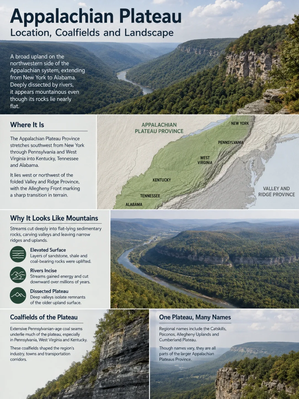
The Appalachian Plateau is a long, deeply dissected upland on the northwestern side of the Appalachian system, extending from New York southwest toward Alabama. Its nearly horizontal sedimentary rocks, deeply cut river valleys and widespread coal-bearing layers produce a landscape that often looks mountainous even though its underlying structure is that of a plateau.
A Long Plateau Province From New York to Alabama
The name Appalachian Plateau commonly refers to the broad plateau region along the western side of the Appalachian Mountains. On formal U.S. physiographic maps, the larger unit is usually called the Appalachian Plateaus Province, with “Plateaus” in the plural because it contains several regional sections rather than one uniform tableland.
The province stretches southwest from New York through the central Appalachian region and into Tennessee and Alabama. It lies west or northwest of the more strongly folded Valley and Ridge Province. Along parts of the boundary, features such as the Allegheny Front create a sharp topographic transition between the plateau country and lower or differently structured terrain to the east.
This is not a narrow mountain crest. It is a broad belt of elevated sedimentary terrain. Some parts retain wide upland surfaces, while others have been cut so deeply by rivers that only ridges and benches preserve the shape of the older plateau surface.
Name and Boundary Note
Appalachian Plateau is widely used as a singular regional name, while Appalachian Plateaus Province is the formal name used in major U.S. physiographic classifications. The exact mapped edge can vary slightly with the classification and scale being used.
Why the Appalachian Plateau Looks More Like Mountains Than a Tableland
A flat-topped image of a plateau does not fit much of Appalachia. From the ground, large parts of the Appalachian Plateau appear as forested mountains, steep valley walls and narrow winding ridges.
The reason becomes clearer when the landscape is viewed as an eroded high surface rather than as a collection of individual peaks. Much of the underlying sandstone, shale and related sedimentary rock remains comparatively flat-lying. Streams have cut downward through these beds for long periods, dividing the original upland into a dense network of valleys and ridges.
Broad layers of late Paleozoic sedimentary rock occupy an elevated position on the western side of the Appalachian system.
Regional uplift and relief gave rivers enough gradient to incise into sandstone, shale and coal-bearing strata.
Deep valleys separate remnants of the older upland, leaving a rugged dissected plateau that can resemble a mountain belt.
This distinction separates much of the Appalachian Plateau from the Valley and Ridge terrain immediately to the east. Valley and Ridge topography strongly reflects folded and tilted rock layers. Across much of the plateau, the rocks are much less deformed at the surface, while erosion supplies much of the visible relief.
The result is one of the clearest examples of why plateau describes a regional landform structure rather than a requirement that every part of the surface remain level.
Allegheny, Catskill and Cumberland Are Parts of a Larger Landscape
Regional names can make the Appalachian Plateau seem more fragmented than it is. The large physiographic province includes areas known by names such as the Catskills, Poconos, Allegheny uplands and Cumberland Plateau. Some are commonly called mountains even though their regional geology and topography belong to the larger Appalachian Plateaus system.
The terminology also changes from north to south. In the northern and central Appalachians, Allegheny Plateau is widely used for large areas of New York, Pennsylvania and neighboring uplands. Farther south, Cumberland Plateau becomes the dominant regional name across parts of Kentucky, Tennessee and Alabama.
These names should not be treated as interchangeable labels for exactly the same mapped area. They describe regional parts of a much longer physiographic province, and their boundaries depend partly on the mapping system being used.
| Regional Area | General Position | Typical Landscape Character |
|---|---|---|
| Catskill and southern New York sections | Northeastern end of the province | Strongly dissected uplands, mountain-like relief and extensive glacial modification |
| Allegheny uplands | Pennsylvania and adjoining central Appalachian areas | Forested ridges, narrow valleys, sandstone uplands and major coal-bearing terrain |
| Kanawha section | Central Appalachian Plateau, especially West Virginia | Dense drainage networks, steep valleys, gorges and strongly dissected high ground |
| Cumberland Plateau | Southern Appalachian region | Broad upland remnants, sandstone cliffs, escarpments, gorges and coal-bearing strata |
| Cumberland Mountain section | Eastern part of the southern plateau system | Higher ridges and stronger mountain-like relief associated with erosion and broad structural folds |
Coal Is Built Into the Sedimentary Rock Stack
The Appalachian Plateau and coal are closely linked because the plateau exposes a thick sequence of late Paleozoic sedimentary rocks. Sandstone, shale, conglomerate and locally limestone occur throughout the province, while Pennsylvanian-age strata contain many of its major coal beds.
These rocks record environments that existed long before the modern Appalachian landscape. Rivers carried sand and mud into low-lying basins and coastal plains. Wetlands repeatedly developed on poorly drained surfaces, allowing large amounts of plant material to accumulate. Burial by later sediment protected some of that organic material from complete decay.
With deeper burial, pressure and geologic time transformed the organic-rich layers into coal. New rivers later cut through the uplifted sedimentary sequence, exposing coal seams along valley walls and hillsides in some areas.
More resistant beds can form cliffs, ledges and ridge caps.
Finer-grained beds commonly weather into gentler or less resistant slopes.
A relatively thin organic-rich layer preserved between other sedimentary beds.
Changing rivers, wetlands and sediment supply created multiple rock and coal horizons rather than one continuous coal sheet.
The rock sequence above is schematic and is not a scale stratigraphic column.
This layered structure matters. Appalachian coal does not form one enormous seam beneath the entire plateau. Individual coal beds vary in thickness, depth, continuity and quality, and many have regional names that can change across state boundaries.
Northern, Central and Southern Appalachian Coalfields
The Appalachian coal region is commonly divided into Northern, Central and Southern Appalachia. This arrangement follows coal geology and production geography rather than the exact boundary of the Appalachian Plateau.
Coalfield Boundary Note
The Appalachian Plateau is a physiographic province, while the Appalachian coal region is a coal-resource and production region. Their footprints overlap across large areas, but they should not be treated as the same boundary on a map.
| Coal Region | Main Areas in the Federal Coal-Production Classification | Relationship to the Plateau Landscape |
|---|---|---|
| Northern Appalachia | Maryland, Ohio, Pennsylvania and northern West Virginia | Includes broad plateau uplands and deeply cut Allegheny terrain with extensive Pennsylvanian coal-bearing rocks. |
| Central Appalachia | Eastern Kentucky, Virginia, southern West Virginia and designated counties in northeastern Tennessee | Much of the coal occurs beneath steep, densely dissected terrain where narrow valleys and high local relief strongly affect access and mining methods. |
| Southern Appalachia | Alabama and designated southeastern Tennessee counties | Coal-bearing terrain continues into the southern Appalachian region, but the coal-production district and the physiographic plateau boundary are not identical. |
Named Coal Beds Show How the Resource Changes Across the Basin
Several well-studied coal beds illustrate the regional pattern. In Northern Appalachia, the Pittsburgh, Upper Freeport and Lower Kittanning beds are major named units. In Central Appalachia, prominent assessed units include the Fire Clay and Pond Creek coal zones and the Pocahontas No. 3 coal bed.
These names do not represent every coal seam in the Appalachian Plateau. They are examples from a much larger stratigraphic system in which different coal beds appear, split, thin, merge or disappear across the basin.
The Pittsburgh coal bed is especially extensive in the northern basin, while the Pocahontas No. 3 is associated with southern West Virginia and southwestern Virginia and is known for relatively low ash and sulfur content and high calorific value. The contrast shows why “Appalachian coal” is not one uniform material.
The Landscape Changes From a Glaciated North to a Gorge-Cut South
The Appalachian Plateau stretches far enough north and south that its present surface cannot be explained by one erosional history.
Northern Plateau
- Pleistocene glaciers crossed and modified large parts of the northern province.
- Existing valleys were deepened, widened or partly blocked by glacial deposits.
- Drainage was reorganized in many areas after the ice retreated.
- The Finger Lakes region shows one of the clearest glacial modifications of the northern plateau landscape.
Central and Southern Plateau
- Fluvial incision dominates much of the visible relief.
- Dense tributary systems divide the upland into ridges and narrow valleys.
- Resistant sandstone commonly forms cliffs, ledges and gorge rims.
- The Cumberland and central Appalachian sections contain some of the strongest dissected-plateau topography.
In New York, glaciation altered a landscape that had already been dissected by rivers. The long Finger Lakes occupy valleys whose form and drainage were heavily modified by glacial ice and deposits.
Farther south, the absence of continental glacial erosion leaves river incision, rock resistance and slope processes much more visible as the main shapers of the plateau surface.
Rivers and Resistant Sandstone Control the Relief
Water is responsible for much of the Appalachian Plateau’s present shape, but erosion does not remove every rock layer at the same rate. Hard sandstone can resist weathering and preserve cliffs or ridge tops, while shale and other weaker beds tend to erode more readily.
This difference helps produce a stepped landscape. Resistant beds form benches, ledges and escarpments. Softer layers retreat beneath them. Tributaries then cut into the slopes from several directions, gradually isolating ridges and narrowing the surviving upland surfaces.
New River Gorge Exposes the Plateau From Top to Bottom
New River Gorge in West Virginia provides an unusually clear cross-section through this structure. The river cuts through the Appalachian Plateau and exposes up to about 3,200 feet (975 m) of sedimentary rock in the gorge, dominated by sandstone and shale with coal-bearing layers in the sequence.
At some locations, incision reaches roughly 1,100 feet (335 m). Resistant sandstone contributes to the steep canyon walls and prominent cliffs. The river’s downward cutting also exposed coal-bearing strata, helping make some deposits accessible during the development of the region’s mining industry.
New River Gorge is therefore more than an isolated canyon. It shows, in one landscape, the relationship among regional uplift, stream incision, sandstone resistance, coal-bearing sedimentary beds and the deeply dissected surface that defines much of the Appalachian Plateau.
Mining Has Added a New Layer of Topographic Change
Natural erosion created the plateau’s ridges and valleys over geologic time, but coal extraction has modified parts of that terrain much more rapidly. The scale and form of change depend on the mining method.
Underground mining follows coal seams beneath the surface and may leave much of the overall ridge profile intact, although subsidence, mine openings, waste material and altered drainage can still affect the landscape. Surface mining changes the terrain more directly because rock above the coal must be removed.
In the steep central Appalachian coalfields, surface methods include contour mining, area mining, highwall mining and mountaintop removal. Where large volumes of rock are removed from above or between coal seams, excess material may be placed in engineered fills in adjoining valleys.
These operations can alter ridge elevations, headwater valleys, drainage paths and vegetation patterns. Regrading and revegetation follow mining, but the resulting terrain does not necessarily reproduce every feature of the pre-mining watershed.
Mine Footprints Can Now Be Tracked Across Decades
A federal geospatial dataset released in 2026 assembled mapped footprints for known active, inactive, abandoned and legacy surface mines across the eastern U.S. Appalachian region. The dataset combines mine boundaries with remotely sensed records of vegetation loss, land-cover change, elevation change and recovery.
Its time-series measurements include surface conditions from the mid-1980s onward, allowing mined land to be studied as a changing landscape rather than simply as a set of mine locations. This is especially useful in Central Appalachia, where natural ridge-and-valley topography and surface-mined terrain can occur within the same watershed.
Coal Production Remains Concentrated in a Defined Appalachian Region
The August 2026 U.S. energy outlook places coal production in the statistical Appalachia region at 160.0 million short tons in 2025, with 154.0 million short tons forecast for 2026 and 156.6 million short tons forecast for 2027.
2025 Appalachia coal production
2026 forecast
2027 forecast
These production figures use the federal Appalachia coal-production region. They should not be interpreted as production occurring only inside the physiographic boundary of the Appalachian Plateau.