INTERACTIVE CONTEXT MAP
Where is Allegheny Plateau?
The selected plateau and nearby mapped locations are shown. Open the full world atlas to explore every region.
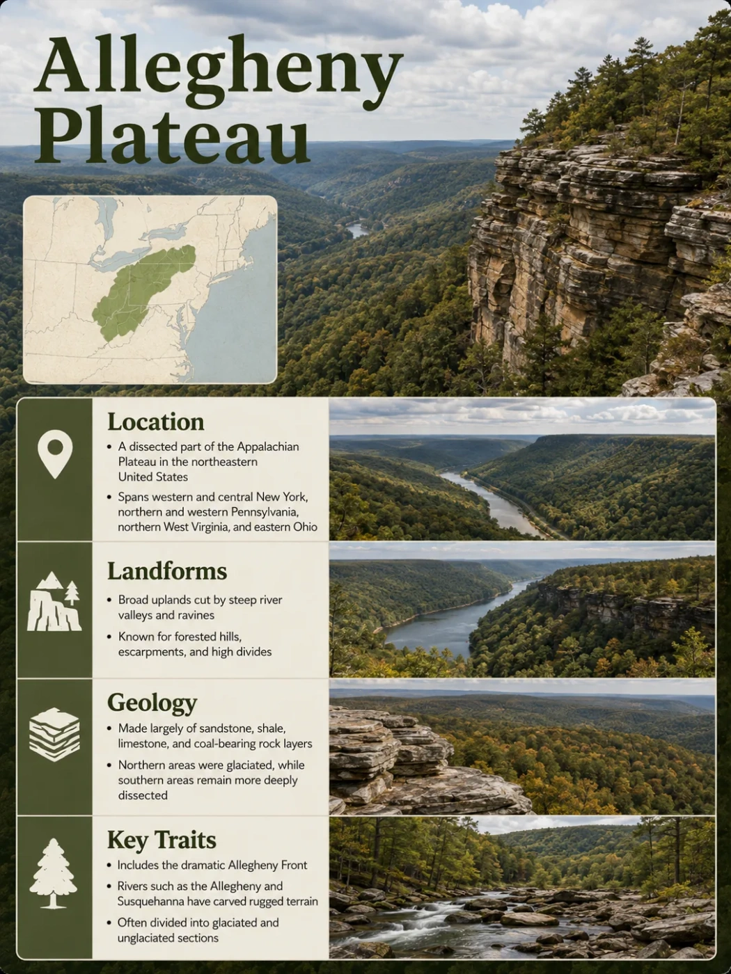
The Allegheny Plateau is a broad, deeply dissected upland on the western side of the Appalachian region in the eastern United States. It extends across much of western and central New York, northern and western Pennsylvania, eastern Ohio, and much of West Virginia. Despite the word plateau, much of its surface is a dense pattern of ridges, steep-sided valleys, ravines, and river-cut hills rather than a flat tableland.
Where the Allegheny Plateau Is Located
The Allegheny Plateau forms part of the larger Appalachian Plateaus physiographic province. The name is most commonly applied to the northern and central part of that province, from southern and western New York through Pennsylvania and eastern Ohio into West Virginia. Farther south, related plateau terrain is commonly identified as the Cumberland Plateau.
Its limits are physical rather than political. State geological agencies divide the Appalachian uplands differently, so the words “Allegheny Plateau” do not produce exactly the same boundary on every physiographic map. Pennsylvania, for example, separates its Appalachian Plateaus into detailed sections such as the Northwestern Glaciated Plateau, High Plateau, Pittsburgh Low Plateau, Deep Valleys, Allegheny Mountain, and Allegheny Front. New York, Ohio, and West Virginia also use regional subdivisions that do not match those Pennsylvania categories one for one.
Naming and Boundary Note
Allegheny Plateau is a regional physiographic name, not a precisely surveyed administrative unit. Boundaries and subregion names vary with the mapping system being used. This is why two reliable maps can show somewhat different divisions without either map necessarily being wrong.
Four names are especially easy to confuse. The Appalachian Plateaus are the larger physiographic province. The Allegheny Plateau is a major northern and central plateau region within that larger system. The Allegheny Mountains refer to more mountainous highland terrain near the eastern side of the plateau province in Pennsylvania and West Virginia. The Allegheny Front is the prominent escarpment and physiographic transition near the province’s eastern margin.
Valley and Ridge terrain with strongly folded rock
Sharp topographic and structural transition
Dissected uplands cut by dense river and stream networks
Generally lower plateau margins grading toward interior lowlands
Conceptual east-to-west relationship; not a scale cross-section or boundary map.
Why the Allegheny Plateau Looks More Like Hills and Mountains
The defining landform problem of the Allegheny Plateau is simple: its plateau character is often difficult to see from the ground. Rivers and tributaries have cut so deeply into the upland that broad parts of the region now appear as repeated hills and ridges separated by valleys.
This is what geographers mean by a dissected plateau. Dissection does not mean that the plateau has disappeared. It means erosion has divided an elevated landscape into smaller upland surfaces by cutting channels and valleys into it.
In strongly dissected parts of northern Pennsylvania and West Virginia, there may be little level terrain outside ridge crests, benches, and valley floors. Local relief can therefore be large even where the underlying rock layers remain much less deformed than those in the folded Appalachian mountains farther east.
Why It Still Counts as a Plateau
A plateau does not have to remain flat at every point. In the Allegheny region, the broader structural and physiographic upland survives even though streams have divided its surface into ridges, valleys, gorges, and narrow interfluves.
Similar ridge-top elevations can sometimes make the broader upland surface easier to recognize on a distant skyline or elevation model. They should not automatically be interpreted as fragments of one perfectly flat ancient surface, however. Geological work in parts of north-central Pennsylvania has shown that some high surfaces are also strongly controlled by resistant sandstone and conglomerate beds. The modern landscape reflects both long-term erosion and the structure of the underlying rock.
The Glacial Border Divides Two Different Allegheny Landscapes
One of the most useful ways to understand the plateau is to follow the southern limit of continental glaciation. Northern sections were overridden by Pleistocene ice sheets, while terrain farther south remained beyond the main ice margin. This produced a noticeable contrast between glaciated and unglaciated parts of the plateau.
Glaciated Allegheny Plateau
- Common across much of southern and western New York, northwestern Pennsylvania, and northeastern Ohio.
- Upland contours are often more rounded or subdued.
- Older valleys were widened, deepened, or otherwise modified by moving ice.
- Some valleys contain thick accumulations of till, outwash, lake sediment, sand, and gravel.
- Glacial alteration created through valleys and locally changed older drainage divides.
Unglaciated Allegheny Plateau
- Dominates large areas farther south in Pennsylvania, Ohio, and West Virginia.
- Long-term stream erosion is more directly expressed in the surface form.
- Narrow ridges, steep hillsides, ravines, and deeply incised valleys are widespread.
- Bedrock differences commonly exert stronger visible control over ridges and slopes.
- The overall terrain can appear distinctly mountainous despite its plateau classification.
The contrast is not simply “smooth north, rugged south.” Glaciated portions can still contain deep and steep-sided valleys, and unglaciated sections can include broad uplands. Ice modified an already dissected landscape rather than replacing it with an entirely new one.
Western New York Shows the Transition Particularly Well
The New York portion of the plateau contains several different glacial expressions within a relatively short distance. The uplands of southern New York were glaciated and commonly show rounded summits together with broad trough-like valleys. Near the Pennsylvania border, however, the Salamanca re-entrant preserves rugged terrain that escaped the most recent continental glaciation.
Farther north, some valleys were strongly aligned and enlarged in the direction of ice movement. These features help explain why the northern Allegheny Plateau cannot be understood purely as a river-cut landscape: ice erosion, glacial deposition, and meltwater drainage are part of its modern form.
Elevation Is Less Informative Than Relief
There is no useful single elevation that describes the entire Allegheny Plateau. The region covers too large an area, and its surface changes substantially from the Ohio side to the highlands near the Allegheny Front. Local relief—the vertical difference between nearby ridge tops and valley floors—often tells more about the terrain than elevation above sea level alone.
In northeastern Ohio, much of the glaciated Allegheny Plateau lies roughly between 1,000 and 1,200 feet above sea level, although higher uplands reach around 1,500 feet. Bedrock valleys there can be hundreds of feet deep and may be partly buried beneath glacial sediment.
North-central Pennsylvania contains much higher and more strongly dissected terrain. Uplands in parts of Potter County rise above 2,500 feet, while deeply cut drainage basins produce large differences between summit and valley elevations.
The broadest regional gradient is especially clear in West Virginia. Plateau elevations near the Ohio River are around 1,000 feet in many places, while terrain rises eastward toward the Allegheny highlands and the Allegheny Front, where elevations exceed 4,000 feet.
Elevation Note
These figures describe different parts of a very large landform and should not be combined into a single “average elevation.” High ground, valley floors, glaciated uplands, and the eastern plateau margin represent different topographic settings.
Rock Layers Control the Shape of Ridges and Valleys
The Allegheny Plateau is underlain mainly by Paleozoic sedimentary rocks, but the exposed formations vary across the region. Sandstone, shale, siltstone, conglomerate, limestone, and coal-bearing sequences occur in different combinations from New York to West Virginia and Ohio.
The structure of these rocks is an important reason the plateau differs from the Valley and Ridge province to the east. Across much of the plateau, beds are relatively flat-lying, gently dipping, or arranged in broad open folds. Folding generally becomes stronger toward the eastern Appalachian margin.
Different rock layers also erode at different rates. Resistant sandstone and conglomerate can support high ridges, ledges, cliffs, and steep valley walls. Less-resistant shale and siltstone tend to weather and erode more readily, helping form slopes and lower terrain. The result is a landscape whose relief is partly a record of differential erosion.
Hard sandstone or conglomerate can preserve ridge crests, benches, and rock ledges while surrounding material is removed.
Shale and other less-resistant units are more easily weathered and commonly underlie slopes or valleys.
Gentle structural changes influence elevation, drainage direction, and the orientation of some valleys without producing the tight ridge pattern found farther east.
This relationship is especially clear in rugged unglaciated terrain. A narrow ridge may survive not because it is a separate mountain range, but because a resistant rock unit has endured erosion better than the beds exposed on the adjoining slopes.
Rivers Have Cut the Plateau Into a Dense Drainage Network
Running water is the main process responsible for the plateau’s dissected appearance. Large rivers establish the major valleys, while thousands of tributaries, creeks, and small headwater channels divide the remaining upland into progressively smaller ridges and spurs.
A branching dendritic drainage pattern is common where streams cross relatively uniform sedimentary rocks. Local folding, joints, and differences in rock resistance can produce more angular or partly rectangular networks in other sections, so the drainage pattern is not identical across the entire plateau.
Sedimentary terrain forms the regional highland surface.
Rivers and tributaries cut downward as water moves toward lower drainage basins.
Weathering, slope movement, and continued erosion widen and deepen the drainage network.
The surviving uplands create the rugged ridge-and-valley appearance seen across much of the plateau today.
In West Virginia, streams including the Monongahela, Little Kanawha, Elk, and Guyandotte systems have cut deeply into plateau rocks. Meandering rivers can become entrenched, preserving winding courses while cutting valleys far below the surrounding uplands.
Drainage direction also changes across the wider region. Much of the central and western plateau ultimately drains toward the Ohio and Mississippi river systems. Parts of its northern and northeastern margin instead feed the Great Lakes or Atlantic-draining systems such as the Susquehanna. North-central Pennsylvania is particularly notable for high watershed divides near the headwaters of the Allegheny, Genesee, and Susquehanna systems.
Glaciation Reworked Northern Drainage
Ice sheets complicated this river-built pattern in the north. Glaciers occupied pre-existing valleys, widened some of them, deposited large volumes of sediment, and blocked or redirected drainage. Meltwater then used new outlets as the ice retreated.
Some northern valleys are therefore much larger than the streams that occupy them today. Others contain thick sediment over buried bedrock channels. The surface drainage visible on a modern map may be only the latest stage of a valley system that predates the last glaciation.
The Allegheny Front Forms the Sharp Eastern Transition
The western edge of the plateau often grades gradually into lower terrain, but the eastern side can be much more abrupt. In Pennsylvania, Maryland, and West Virginia, the Allegheny Front marks a major transition between the Appalachian Plateaus and the folded Valley and Ridge province.
The Front is an escarpment rather than a single isolated mountain ridge. From the east it can look like a wall of high ground because elevation rises quickly toward the plateau province. West of it, the terrain does not immediately become flat; high ridges, broad uplands, and deeply dissected valleys continue across the Allegheny highlands and adjoining plateau.
This is also a structural transition. Rocks in the Valley and Ridge province are strongly folded and faulted, producing long parallel ridges and valleys. Moving west toward and across the Front, deformation generally becomes less intense and the strata of the plateau become more gently folded or nearly flat-lying.
Common Mix-Up
Allegheny Front, Allegheny Mountains, and Allegheny Plateau are related geographic names, but they describe different features. The Front is the major eastern escarpment and physiographic transition; the Allegheny Mountains are highland terrain near that margin; the Allegheny Plateau is the much broader dissected region extending westward.
Landform Features That Identify the Allegheny Plateau
No single feature occurs everywhere, but several landform patterns repeatedly distinguish Allegheny Plateau terrain. Their expression changes with bedrock, elevation, glacial history, and the depth of river incision.
| Landform Feature | Typical Appearance | Main Control |
|---|---|---|
| Dissected uplands | High ground divided into many ridges and valleys | Long-term stream incision into the plateau |
| Narrow ridges and interfluves | Elongated high ground between neighboring drainage valleys | Progressive expansion of tributary networks and resistant bedrock |
| Steep-sided valleys | Deep valleys with large local relief | River incision, weathering, and slope erosion |
| Broad rounded uplands | Smoother summits and subdued high ground | Common in glaciated sections where ice modified older terrain |
| Through valleys | Large valleys or troughs that cross older drainage divides | Especially associated with glacial modification in the northern plateau |
| Rock ledges and cliffs | Locally abrupt sandstone or conglomerate faces | Differential erosion of resistant and weaker strata |
| Entrenched meanders | Winding river bends cut deeply into bedrock | Downcutting by rivers that retained established meandering courses |
| Escarpment terrain | Sharp regional rise along the eastern plateau margin | Topographic and structural transition at the Allegheny Front |
How the Allegheny Plateau Appears on a Topographic Map
A topographic map often reveals the plateau more clearly than a ground-level view. The most useful clue is not a broad empty area enclosed by one contour line. It is the relationship between upland elevations, valley incision, drainage pattern, and regional slope.
Closely Spaced Contours Follow Deep Valleys
Where rivers have cut deeply into the plateau, contour lines crowd together along valley walls. Narrow contour spacing therefore traces much of the rugged local relief even when the ridge tops form a broader regional upland.
Branching Valleys Divide the Upland
Dendritic stream networks create repeated Y-shaped junctions and divide the landscape into branching ridges. In structurally influenced sections, some tributaries turn more sharply and produce angular patterns instead.
Glaciated Valleys Can Be Disproportionately Broad
Across southern New York and other northern sections, broad troughs may interrupt the narrower pattern expected from ordinary stream erosion. These valleys can reflect glacial enlargement, sediment-filled bedrock channels, or drainage routes reorganized during deglaciation.
The Eastern Margin Shows a Strong Elevation Break
Near the Allegheny Front, shaded-relief and contour maps show a much sharper transition than across most of the plateau interior. The abrupt rise helps distinguish the eastern edge of the Appalachian Plateaus from the parallel folded terrain of the Valley and Ridge province.
Similar Summit Heights Need Careful Interpretation
Ridge tops that reach broadly similar elevations can reveal the regional plateau form, but they are not automatic proof of a single preserved ancient plain. Resistant rock layers, structural dip, erosion history, and glacial modification can all influence which uplands remain high. On the Allegheny Plateau, the most accurate reading comes from combining summit patterns with geology, drainage, and local relief rather than relying on flatness alone.