Interactive Map of Major Plateaus of the World
Colored areas show approximate plateau regions. Click a highlighted area or choose a name from the list to explore its location, elevation pattern, and map-reading clue.
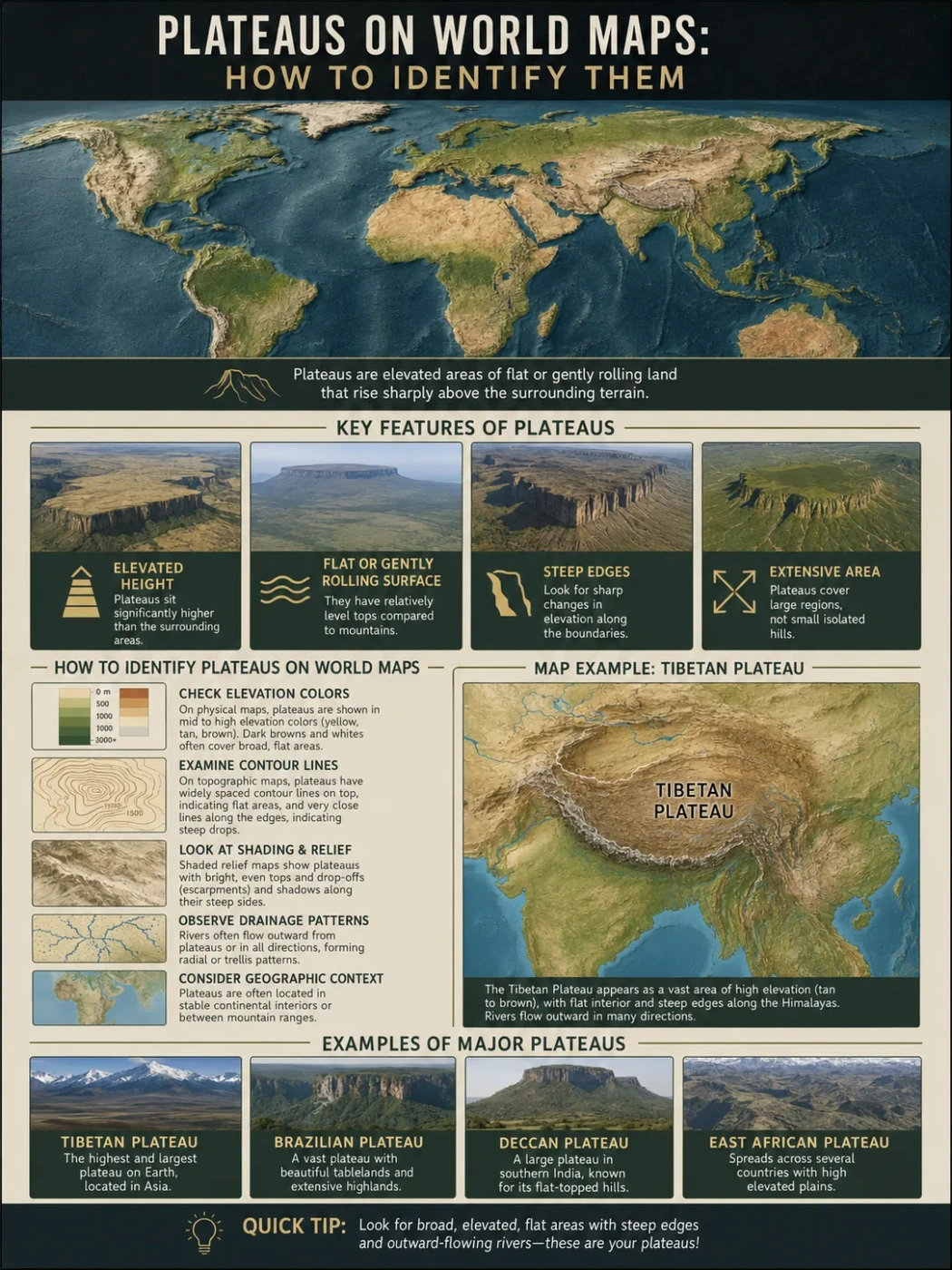
A plateau on a world map is usually shown as a broad area of elevated land that is flatter than nearby mountains but higher than surrounding plains, basins, or lowlands. The hard part is that plateaus do not always look like perfect tables. Some are smooth and open. Others are cut by rivers, edged by steep scarps, surrounded by mountains, or broken into smaller uplands.
To identify a plateau on a map, look for a raised surface first, then check its shape, edges, drainage, and surrounding landforms. A plateau is not just “high land.” It is a raised landform with a relatively level or gently rolling surface, often bordered by slopes, mountains, escarpments, valleys, or lower basins.
| Map Feature | What to Look For | Why It Matters |
|---|---|---|
| Elevation | Higher color bands, elevation labels, or contour values | A plateau must stand above nearby land |
| Surface Shape | Broad, fairly even land rather than sharp peaks | This separates a plateau from a mountain range |
| Edges | Steep slopes, escarpments, canyon rims, or sudden elevation changes | Many plateaus have clear margins where highland drops to lowland |
| Drainage | Rivers cutting across or around the raised surface | Rivers often reveal whether the land is a dissected plateau |
| Nearby Landforms | Mountains, plains, basins, deserts, highlands, or rift valleys | A plateau is easiest to read by comparing it with its surroundings |
What a Plateau Means on a World Map
A plateau is a raised, fairly flat landform. It may sit hundreds or thousands of meters above sea level, but elevation alone does not define it. The shape of the land matters just as much.
On a world physical map, a plateau may appear as a wide patch of brown, tan, orange, or darker green depending on the map’s color system. On a topographic map, it may show as an area where contour lines form a high surface with gentler spacing across the top and tighter spacing along one or more edges.
The simplest map-reading test is this:
- Is the area higher than nearby land?
- Does it have a broad surface rather than a chain of sharp peaks?
- Does it have visible edges, slopes, escarpments, or deeply cut valleys?
- Does the name or regional label include words such as plateau, highland, tableland, mesa, or upland?
If several of these clues appear together, the landform is likely a plateau or part of a plateau region.
Map Note: Not every plateau is labeled clearly on small world maps. Some appear under broader regional names such as highlands, uplands, basin and range, or a local geographic name.
Why Plateaus Can Be Hard to Identify
Plateaus are easy to define but not always easy to see. A school diagram may show a plateau as a flat block with steep sides. Real landscapes are less tidy.
Some plateaus are high and open, such as the Tibetan Plateau. Some are volcanic and broad, such as the Deccan Plateau in India. Some are carved into canyons and mesas, such as parts of the Colorado Plateau in the southwestern United States.
On maps, these differences can hide the basic pattern. A plateau may look like:
- a large brown highland region;
- a raised basin between mountain ranges;
- a broad volcanic surface;
- a dissected upland cut by rivers;
- a stepped surface between mountains and plains;
- a table-like landform with steep sides in dry regions.
Scale also matters. A large world map may show only the main plateau region, while a regional map may reveal escarpments, river valleys, lava layers, mesas, and local basins.
Start with Elevation, But Do Not Stop There
Elevation is the first clue. Plateaus stand above the surrounding land, so they often appear in higher color bands on physical maps. Many maps use green for lowlands, yellow or tan for moderate elevations, and brown for highlands, though color schemes vary.
Still, color alone can mislead. A mountain range and a plateau may both appear brown. The difference is in surface form.
How Elevation Helps
Elevation can show whether the land is raised. A plateau may be about a few hundred meters above nearby plains, or it may sit several thousand meters above sea level. The Tibetan Plateau, for example, is often described as averaging more than 4,000 meters above sea level, while other plateaus are much lower.
When reading elevation, compare the plateau with its surroundings rather than judging it by sea level alone.
| Map Clue | Possible Meaning | Plateau Reading Tip |
|---|---|---|
| Large area in a higher color band | Raised land or highland region | Check whether the surface is broad, not peak-like |
| Sudden color change at the edge | Steep slope, scarp, or plateau margin | Look for a long boundary between high and low land |
| High land surrounded by mountains | Possible intermontane plateau | Check if the interior is flatter than the mountain rim |
| High land cut by deep rivers | Possible dissected plateau | Look for canyons, gorges, and branching valleys |
Why Relative Height Matters
A plateau does not need to be among the highest places on Earth. It only needs to be elevated compared with nearby land. A plateau beside a low plain may be easy to notice even if it is not extremely high above sea level.
This is why regional context matters. A plateau in East Africa, Anatolia, Brazil, India, or southern Africa may look different on a global map, but each can be read by comparing the raised surface with neighboring lowlands, basins, mountains, or coast-facing slopes.
Elevation Note: A high plain is not always a plateau, and a plateau is not always very high in global terms. The main clue is a raised surface that stands above surrounding terrain.
Look for a Broad Surface, Not a Line of Peaks
The surface of a plateau is usually broader and more even than a mountain range. It may be gently rolling, tilted, broken by valleys, or covered by smaller hills, but it does not form one narrow chain of peaks.
On a physical map, mountains often appear as long, sharp belts. Plateaus appear as wider blocks, shelves, uplands, or interior high surfaces.
Plateau Shape on Small-Scale World Maps
World maps simplify landforms. They cannot show every ridge, canyon, mesa, or lava layer. Because of this, plateaus often appear as large highland zones rather than detailed landform outlines.
Good examples include:
- Tibetan Plateau: a vast high surface north of the Himalayas.
- Deccan Plateau: a broad peninsula upland in India.
- Colorado Plateau: an elevated region known for deeply cut river landscapes.
- Brazilian Highlands: a large upland region with plateau-like areas and escarpments.
- East African Plateau: a broad raised region shaped by uplift, rifting, lakes, and volcanic landforms.
- Iranian Plateau: a high interior region between major mountain belts.
Plateau Shape on Topographic Maps
On topographic maps, contour lines help show the land’s form. Contour lines connect points of equal elevation. When contours are close together, the slope is steep. When they are more widely spaced, the slope is gentler.
A plateau may show:
- wider contour spacing across the top surface;
- closer contour spacing along edges or valley walls;
- river valleys cutting into the raised surface;
- flat-topped hills or mesas on the plateau surface;
- a higher contour level spread across a wide area.
The best clue is the pattern: a broad elevated area with a less steep surface on top and steeper drops along parts of its edge.
Use Escarpments to Find Plateau Edges
An escarpment is a long, steep slope or cliff-like edge between higher and lower land. Many plateaus have escarpments along one or more sides, especially where uplift, erosion, faulting, or river cutting has shaped a sharp boundary.
On a map, escarpments may appear as:
- closely spaced contour lines along a long edge;
- a sudden change from highland colors to lowland colors;
- a steep shaded-relief boundary;
- place names that include “scarp,” “escarpment,” “edge,” “rim,” or local equivalents;
- rivers flowing down from high land toward plains or basins.
Why Edges Are Often More Visible Than the Top
The top of a plateau may look plain or gently uneven. The edge often gives it away. A sharp margin between a high surface and a lower plain can be easier to identify than the plateau surface itself.
This is especially true in plateau regions such as southern Africa, parts of Brazil, the Deccan region, and canyon country in western North America, where plateau margins and river cuts help reveal the raised landform.
Landform Note: A plateau can have steep edges without being flat like a tabletop everywhere. Many real plateaus are tilted, eroded, folded, or broken into smaller surfaces.
Read the Rivers and Basins Around the Plateau
Rivers help reveal plateaus because water follows slope. On a plateau, rivers may begin on the high surface, cut deep valleys through it, or flow outward toward surrounding plains and basins.
A map reader should ask: Where does the water go?
Rivers Cutting Through Plateaus
Some plateaus are dissected plateaus. This means rivers and erosion have cut valleys, gorges, canyons, and ridges into the raised land. The plateau may no longer look smooth, but the wider region still sits on a raised surface.
In these areas, maps often show river systems deeply incised into high land. The Colorado Plateau is a familiar example because the Colorado River and its tributaries have carved canyons into an elevated region.
Rivers Starting on Plateaus
Plateaus can also act as water-dividing regions. Rivers may rise from the plateau surface and flow in different directions. This can be seen in several highland and plateau regions where elevation helps shape drainage patterns.
When many rivers flow outward from a raised area, that area may be a plateau, highland, or mountain mass. The next step is to check the shape: is it a rugged peak belt, or a broad elevated surface?
Basins Beside or Within Plateaus
A basin is a lower area where water, sediment, or drainage collects. Some plateaus sit beside basins. Others contain internal basins, dry valleys, salt flats, or lake basins.
On a map, this contrast can help. A high plateau beside a lower basin may show a clear elevation step. An interior plateau basin may look like a raised bowl surrounded by mountain rims or uplands.
Compare Plateaus with Mountains, Plains, Highlands, and Mesas
Many map-reading mistakes come from mixing plateaus with nearby landforms. The terms overlap in everyday use, but they do not mean the same thing.
| Landform | Main Shape | Map Clue | How It Differs from a Plateau |
|---|---|---|---|
| Mountain Range | Long belt of peaks and ridges | Tight contours, sharp relief, narrow high zones | More rugged and peak-based |
| Plain | Low or gently rolling land | Low elevation colors and weak relief | Usually not raised above nearby terrain |
| Highland | Broad elevated region | Large upland area, often mixed terrain | May include plateaus, hills, mountains, and valleys |
| Mesa | Small flat-topped hill or tableland | Flat top with steep sides, usually local scale | Much smaller than most plateau regions |
| Basin | Lower collecting area | Drainage flows inward or through a lower zone | Usually lower than surrounding land, not raised |
Plateau vs Mountain Range
A mountain range is usually a narrow or curved belt of peaks, ridges, passes, and steep slopes. A plateau is broader and more surface-based. It may be surrounded by mountains, but its interior is often flatter than the mountain rim.
The Tibetan Plateau shows this well. It sits north of the Himalayas and between major Asian mountain systems, but the plateau itself is not just one mountain chain. It is a vast high surface with basins, valleys, lakes, and interior ranges.
Plateau vs Plain
A plain is usually broad and low or gently rolling. A plateau can also be broad and gently rolling, which causes confusion. The difference is elevation relative to surrounding land.
A raised plain-like surface can be a plateau. A low flat surface near a coast, river valley, or sedimentary basin is usually a plain.
Plateau vs Highland
Highland is a broader word. It can include plateaus, hills, mountains, uplands, and rugged terrain. A plateau may be part of a highland region, but not every highland is a plateau.
On world maps, many plateau regions appear under names such as “Highlands” because the area includes mixed raised landforms. In that case, look for broad elevated surfaces inside the highland region.
Plateau vs Mesa
A mesa is usually smaller than a plateau. It is a flat-topped hill or tableland with steep sides, often formed when erosion leaves a resistant caprock above softer layers. Mesas can occur on plateau landscapes.
A useful rule: a mesa can sit on or near a plateau, but a plateau covers a much larger raised area.
Identify Plateau Types on Maps
Different plateau types create different map patterns. Knowing the type can help explain why one plateau looks like a smooth raised surface while another looks rough, volcanic, or cut by rivers.
| Plateau Type | How It Forms | Map Pattern | Example Regions |
|---|---|---|---|
| Intermontane Plateau | Raised or held between mountain ranges | High interior surface surrounded by mountains | Tibetan Plateau, Altiplano, Iranian Plateau |
| Volcanic Plateau | Built by lava flows or volcanic materials | Broad lava surface, stepped edges, basalt regions | Deccan Plateau, Columbia Plateau, Ethiopian Highlands in part |
| Dissected Plateau | Raised land cut by rivers and erosion | Canyons, valleys, ridges, irregular drainage | Colorado Plateau, parts of the Appalachian Plateau |
| Piedmont Plateau | Raised land near the foot of mountains | Upland surface between mountains and lower plains | Piedmont regions near mountain fronts |
Intermontane Plateaus
An intermontane plateau lies between mountain ranges. On a world map, it may look like a high interior region enclosed or partly enclosed by mountains.
Look for mountain belts around the plateau and a broad raised area inside them. The interior may include basins, lakes, dry valleys, smaller ranges, and river headwaters.
Volcanic Plateaus
A volcanic plateau forms when repeated lava flows or volcanic materials build a wide elevated surface. These plateaus can be large and layered, especially where basalt flows spread across wide areas.
On maps, volcanic plateaus may not always show obvious volcano shapes. Instead, they may appear as broad uplands with step-like edges, dark volcanic rock regions on geologic maps, or long river cuts through layered lava.
Dissected Plateaus
A dissected plateau has been cut by rivers and erosion. It may look rugged on maps because valleys, canyons, and ridges break the original surface.
Do not mistake ruggedness for mountains automatically. If the wider area remains a raised surface with many river-cut valleys, it may still be a plateau region.
Piedmont Plateaus
A piedmont plateau sits near the base of mountains and slopes toward lower land. It often forms a transition zone between a mountain front and a plain or coastal lowland.
On a map, it may appear as a raised belt or upland shelf next to a mountain chain.
How Color, Shaded Relief, and Contours Work Together
No single map symbol proves that an area is a plateau. The most reliable reading comes from combining several map clues.
Physical Map Colors
Physical maps often use color to show elevation. Higher land may appear in yellow, tan, brown, or white. Lower land may appear green. But each map uses its own scale, so always read the legend.
For plateaus, color helps most when a wide area stays in a similar high-elevation band. A mountain range may show sharp, narrow high zones. A plateau often shows a broader high zone with less dramatic surface variation.
Shaded Relief
Shaded relief uses light and shadow to show land shape. Plateaus may appear as raised blocks, broad uplands, or high surfaces bordered by shadowed scarps and valley walls.
Shaded relief is useful because it shows the edge and texture of the plateau. A smooth plateau, a dissected plateau, and a mountain range can look very different when relief shading is clear.
Contour Lines
Contour lines are the best tool for detailed plateau reading. They show both height and shape. On a plateau, the top surface may show gentler contour spacing, while the edges or valleys may show close spacing.
Follow the contour values across the map. If a wide area remains at a high elevation and then drops sharply along one side, that is a strong plateau clue.
A Step-by-Step Way to Identify Plateaus on Maps
A simple reading sequence helps avoid guessing. Use the same steps whether the map is a school world map, an atlas, a digital relief map, or a topographic sheet.
1. Find the High Land
Start with the elevation legend. Locate wide areas of higher land, not just isolated peaks. On a world map, these may appear as brown, tan, or darker shaded regions.
2. Check the Surface Width
Ask whether the high land is broad enough to be a surface. A narrow ridge is not a plateau. A wide raised region with a flatter or rolling top may be one.
3. Look for Edges and Drops
Search for escarpments, steep slopes, canyon rims, or sudden changes in elevation color. These often mark the boundary between the plateau and nearby lower land.
4. Read the Drainage
Follow rivers. Rivers may cut down through the plateau, flow outward from it, or mark valleys along its edge. Deep, branching valleys inside high land may point to a dissected plateau.
5. Compare Nearby Landforms
Check what surrounds the area. Mountains may enclose an intermontane plateau. Plains may sit below a plateau edge. Basins may lie beside or inside the plateau region.
6. Check the Name, But Do Not Rely on It Alone
Names help, but they are not enough. Some plateau regions are labeled as highlands, uplands, tablelands, or regional names. Other maps may label only the country, state, or mountain system.
World Map Examples of Plateau Identification
World maps show plateaus at different levels of detail. Some famous examples are easy to locate. Others need careful reading because they blend into highlands, basins, or mountain belts.
Tibetan Plateau
The Tibetan Plateau is one of the clearest plateau examples on world maps. It lies north of the Himalayas and is often shown as a huge high-elevation region in Asia.
Map clues include very high elevation, nearby mountain chains, interior basins, river headwaters, and a broad surface rather than a single ridge. It is commonly called the “Roof of the World,” though that phrase is best understood as a description of its extreme elevation and scale, not as a technical landform term.
Deccan Plateau
The Deccan Plateau covers much of peninsular India. It is often shown as a broad upland south of the Indo-Gangetic Plain and between the Western Ghats and Eastern Ghats.
Map clues include a large raised surface, river systems crossing the peninsula, and escarpment-like mountain margins near the western side. Its volcanic history is often linked with the Deccan Traps, a large basalt province.
Colorado Plateau
The Colorado Plateau lies in the southwestern United States. It is not just a flat high surface. It is famous for canyons, mesas, buttes, and deeply cut river landscapes.
Map clues include elevated land, river incision, canyon systems, and broad uplands between basins and mountain regions. It is a good example of why a plateau can look rugged while still being a plateau.
Altiplano
The Altiplano is a high plateau region in the central Andes of South America. It sits between Andean mountain ranges and includes basins, lakes, salt flats, and high plains.
Map clues include its position between mountain belts, high elevation, and interior drainage features. It is an intermontane plateau rather than a low plain.
East African Plateau
The East African Plateau is a broad raised region shaped by uplift, rift systems, lakes, volcanic highlands, and drainage divides. On maps, it may not appear as one simple block.
Map clues include highland colors, rift valleys, major lakes, volcanic areas, and rivers that connect the raised interior to surrounding basins and coastal regions.
Common Map-Reading Mistakes
Plateaus are often misread because maps compress complex terrain into colors, lines, and labels. The most common mistakes come from relying on only one clue.
Mistake 1: Thinking Every Brown Area Is a Plateau
Brown or tan colors often show high elevation, but high elevation can mean mountains, uplands, plateaus, or high basins. Always check surface shape and relief.
Mistake 2: Expecting Plateaus to Be Perfectly Flat
Many plateaus are not flat in a strict sense. They may be tilted, eroded, dissected, or covered with hills. The important idea is a broad raised surface compared with nearby land.
Mistake 3: Confusing Mesas with Large Plateaus
Mesas are small flat-topped landforms. They can be part of plateau landscapes, especially in dry regions, but they do not cover the same scale as a major plateau.
Mistake 4: Ignoring Rivers
Rivers often explain plateau shape. They cut canyons, mark drainage divides, show slope direction, and reveal whether the land has been deeply dissected.
Mistake 5: Treating Political Borders as Landform Borders
Plateaus rarely stop at country borders. A plateau may cross regions, states, provinces, or countries. Physical geography should be read through elevation, relief, rock structure, and drainage, not only through political lines.
How Plateaus Affect Climate and Human Geography on Maps
Plateaus can shape climate, settlement, farming, transport routes, and water systems. A world map may not show all of this directly, but the landform gives useful clues.
Climate Patterns
Elevation often makes plateau climates cooler than nearby lowlands. Some plateaus are dry because mountains block moist air or because the interior is far from oceans. Others support grasslands, farms, forests, or highland cities depending on latitude, rainfall, and local relief.
On climate maps, plateaus may appear as cooler or drier zones than surrounding lowlands. In tropical regions, elevation can create milder highland climates.
Rivers and Water Supply
Plateaus often act as source areas for rivers. Their raised surfaces can feed streams that flow toward lower basins, plains, and coasts. Where rivers cut deeply into a plateau, they may form gorges, canyons, and steep valleys.
This makes plateaus important for reading river basin patterns on world maps.
Settlement and Transport
Human settlement on plateaus depends on water, soil, climate, slope, and access. Some plateau regions support large cities and farming zones. Others are sparsely settled because of aridity, altitude, cold, steep margins, or limited water.
Roads and railways may follow gentler plateau surfaces, river valleys, passes, or basin edges. Steep escarpments can limit direct routes between highland and lowland areas.
Simple Rules for Recognizing Plateaus
When a map looks confusing, use these short rules:
- High plus broad is the first plateau clue.
- Flat-looking does not mean low; a plateau can look plain-like but sit high.
- Steep edges matter; escarpments often mark plateau margins.
- Rivers reveal the surface; canyons and branching valleys may show a dissected plateau.
- Mountain rims can hide plateaus; look inside mountain belts for intermontane surfaces.
- Names can help, but landform evidence matters more than labels.
Mini Glossary for Reading Plateaus on Maps
| Term | Meaning | Why It Helps |
|---|---|---|
| Plateau | Broad raised land with a fairly level or gently rolling surface | The main landform being identified |
| Escarpment | Long steep slope or edge between high and low land | Often marks a plateau margin |
| Contour Line | Line joining points of equal elevation | Shows height, slope, and landform shape |
| Dissected Plateau | Plateau cut by rivers and erosion | Explains rugged plateau landscapes |
| Intermontane Plateau | Plateau between mountain ranges | Helps identify high interior plateaus |
| Basin | Lower area where water or sediment collects | Often contrasts with nearby plateaus |
| Mesa | Small flat-topped hill with steep sides | Commonly confused with a plateau |
FAQ
How can I identify a plateau on a world map?
Look for a broad area of elevated land that stands above nearby plains, basins, or lowlands. Then check whether the surface is fairly wide, whether it has steep edges or escarpments, and whether rivers cut across or drain away from it.
Is a plateau the same as a mountain?
No. A mountain usually rises as a peak or rugged ridge, while a plateau is a broader raised surface. Some plateaus are surrounded by mountains, and some contain smaller mountain ranges, but the landform itself is defined by its elevated surface.
Why do some plateaus look rough on maps?
Some plateaus look rough because rivers and erosion have cut valleys, canyons, and ridges into the raised surface. These are often called dissected plateaus. The wider region may still be a plateau even if the surface is no longer smooth.
What map symbols help show plateaus?
Useful map clues include elevation colors, contour lines, shaded relief, escarpment labels, river valleys, and regional names such as plateau, highland, upland, or tableland. The best reading comes from using several clues together.
Can a plateau cross more than one country?
Yes. Plateaus are physical landforms, so they do not always follow political borders. Large plateau regions can extend across several countries, states, provinces, or cultural regions.