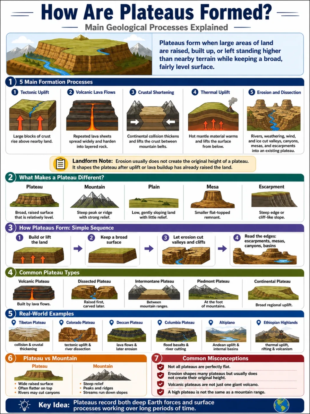
Plateaus form when large areas of land are raised, built up, or left standing higher than nearby terrain while keeping a broad, fairly level surface. The main geological processes are tectonic uplift, volcanic lava flows, crustal shortening, thermal uplift from hot mantle, and later erosion by rivers, wind, ice, and weathering.
A plateau is not formed by one single recipe. Some plateaus rise as blocks of crust. Some grow from repeated lava sheets. Others sit between mountain ranges where the crust has been squeezed, thickened, and lifted. After that, erosion cuts valleys, canyons, mesas, and escarpments into the surface.
| Process | How It Works | Typical Plateau Type | Common Landscape Clues | Example Regions |
|---|---|---|---|---|
| Tectonic uplift | Large blocks of crust rise above nearby land. | Uplifted or dissected plateau | High elevation, river-cut valleys, steep edges | Colorado Plateau, parts of East Africa |
| Volcanic lava flows | Repeated lava eruptions spread across wide areas and harden into layers. | Lava plateau or volcanic plateau | Basalt layers, step-like slopes, broad dark rock surfaces | Deccan Plateau, Columbia Plateau |
| Crustal shortening | Continental plates collide, squeeze the crust, and thicken it. | Intermontane plateau | High basins between mountain ranges | Tibetan Plateau, Altiplano |
| Thermal uplift | Hot material below the lithosphere warms and lifts the surface. | Broad highland plateau | Domed highland, rift valleys nearby, scattered volcanism | Ethiopian Highlands, Yellowstone Plateau |
| Erosion and dissection | Rivers and weathering cut into an already raised surface. | Dissected plateau | Canyons, mesas, buttes, ravines, exposed rock layers | Colorado Plateau, parts of the Deccan |
Landform Note: Erosion usually does not create the original height of a plateau. It shapes the plateau after uplift or lava buildup has already placed the land above its surroundings.
What Makes a Plateau Different from Other Landforms?
A plateau is an elevated landform with a broad top that is flatter than the mountains, hills, or escarpments around it. It may be smooth, gently rolling, deeply cut by rivers, or broken into smaller tablelands.
The most useful clue is not perfect flatness. It is the mix of height, width, and relative surface levelness. A plateau can stand thousands of meters above sea level and still look open, wide, and less jagged than a mountain chain.
- Plateau: broad, raised surface with a mostly level or gently rolling top.
- Mountain: steep, high landform with sharp relief and a peak or ridge.
- Plain: low or gently sloping land, usually not raised sharply above nearby terrain.
- Mesa: smaller flat-topped landform, often left behind after erosion cuts a plateau.
- Escarpment: steep slope or cliff-like edge marking a sudden change in elevation.
The Short Answer: Plateaus Form by Uplift, Lava, Heat, Compression and Erosion
The main answer is simple: plateaus form when the Earth’s surface is lifted upward or built upward over a wide area, then modified by erosion.
Geologists usually explain plateau formation through a few linked processes:
- Tectonic uplift raises a broad crustal block.
- Volcanic eruptions spread lava sheets that build thick rock layers.
- Plate collision squeezes and thickens the crust between mountain belts.
- Hot mantle material warms and lifts the lithosphere from below.
- Rivers and weathering cut valleys, canyons, and escarpments into the raised surface.
Most real plateaus show more than one of these processes. A plateau may begin with tectonic uplift, receive volcanic rocks later, and then spend millions of years being carved by rivers.
Process 1: Tectonic Uplift Raises Broad Land Surfaces
Tectonic uplift happens when forces inside the Earth raise part of the crust. The land does not need to become a sharp mountain range. If the uplift affects a wide block, the result can be a high, broad tableland.
This kind of plateau often starts as a relatively level or layered surface. As the crust rises, rivers gain more energy because the land now sits higher above base level. The rivers cut downward, forming valleys and canyons.
How Uplift Creates a Plateau
The process can be read as a sequence:
- A broad block of crust is pushed upward.
- The raised surface stays wide rather than folding into sharp peaks.
- Rivers begin cutting into the uplifted land.
- Harder rock layers resist erosion and protect parts of the surface.
- Escarpments, canyons, mesas, and buttes may form along the edges and valleys.
The Colorado Plateau is often used as an example of an uplifted and dissected plateau. Its surface stands high above nearby lowlands, while rivers have carved deep canyons through layered rock.
Map Note: On a physical map, an uplifted plateau often appears as a broad high area crossed by river valleys. The surface may look flat from far away, but contour lines tighten along canyon walls and escarpments.
Why Uplifted Plateaus Become Dissected
A dissected plateau is not a separate origin story by itself. It is usually a plateau that has already been raised, then cut by erosion.
As rivers flow across the high surface, they cut into rock layers. Over time, the original plateau top may become broken into ridges, valleys, mesas, and isolated flat-topped remnants. This is why a dissected plateau can look rugged even though it began as a broad elevated surface.
Process 2: Lava Flows Build Volcanic Plateaus
A volcanic plateau forms when lava spreads over a wide region and hardens into stacked layers of igneous rock. These eruptions are often not cone-shaped like a single volcano. Instead, lava can pour from long cracks called fissures.
Basaltic lava is important here because it can flow over broad areas before cooling. One flow covers older terrain. Later flows cover that layer. After many eruptions, the land becomes a thick volcanic tableland.
How Lava Plateaus Form Step by Step
- Molten rock reaches the surface through vents or fissures.
- Low-viscosity lava spreads outward in sheets.
- The lava cools into basalt or related volcanic rock.
- New flows cover older flows, making a layered stack.
- Erosion later cuts valleys, steps, cliffs, and river gorges into the basalt.
The Deccan Plateau in India and the Columbia Plateau in the northwestern United States are well-known volcanic plateau regions. Both are linked with thick basalt layers, although their landscapes and later erosion histories differ.
Why Many Lava Plateaus Have Step-Like Edges
Some volcanic plateaus show terraced slopes because lava flows cool in layers. Hard basalt beds may resist erosion, while weaker layers or joints break down faster. This can create a stair-step look along slopes and valley walls.
The word “trap” used in some volcanic regions comes from a term linked with stairs. That is why names like Deccan Traps are tied to layered basalt landscapes.
Process 3: Plate Collision and Crustal Shortening Make High Intermontane Plateaus
Some of the highest plateaus form where continental plates collide. The crust is squeezed, folded, faulted, and thickened. Instead of all the deformation becoming narrow mountain ridges, some of the thickened crust supports wide high basins and tablelands.
This process is called crustal shortening. It often forms intermontane plateaus, which sit between mountain ranges.
How Crustal Shortening Builds Elevation
When plates push into each other, rock layers may fold, fault, and stack. The crust becomes thicker. Thick crust can stand higher, much like a thicker block floating higher than a thinner one.
The Tibetan Plateau is the best-known high plateau linked with continental collision. It sits north of the Himalayas and reaches an average elevation often described as more than 4,000 meters. The Altiplano in the central Andes is another major high plateau, lying between Andean mountain belts in Bolivia and Peru.
Why These Plateaus Often Have Internal Basins
High plateaus formed between mountains may hold basins with limited drainage. Water can collect in lakes, salt flats, wetlands, or closed basins instead of flowing directly to the sea.
This is common in dry highland settings. Evaporation may remove water faster than rivers can carry it away, leaving salt flats or mineral-rich lake beds.
Process 4: Heat from Below Can Lift a Wide Region
Some plateaus rise because the lithosphere is heated from below. Hot material in the upper mantle can warm, expand, and lift the overlying crust. This type of uplift can affect a broad region rather than one narrow mountain belt.
Thermal uplift may happen near mantle upwelling, hot spots, or rift systems. It may also appear with volcanism, but it does not always mean the entire plateau is covered by lava.
What Thermal Uplift Looks Like on the Surface
A thermally uplifted region may form a broad highland with:
- gentle doming over a wide area,
- rift valleys or fault-bounded basins nearby,
- volcanic fields in some areas,
- river systems that cut down into the raised land,
- steep margins where the highland drops toward lower terrain.
The Ethiopian Highlands and parts of East Africa are often discussed in relation to uplift, rifting, and volcanism. In these settings, heat, faulting, lava, and erosion may all work together.
Process 5: Erosion Shapes Plateaus After They Form
Erosion is the great sculptor of plateaus. Once a surface is raised or built by lava, rivers, rain, wind, ice, and gravity begin to reshape it.
This explains why plateaus rarely look like perfect tables. A plateau may include canyons, narrow valleys, badlands, mesas, buttes, cliffs, and scarps while still being part of one larger elevated landform.
Rivers Cut Canyons and Valleys
Rivers respond strongly to elevation. When land rises, water gains a steeper path toward lower ground. That extra gradient helps rivers cut downward into rock.
On a plateau, river erosion can create:
- deep canyons where rivers cut through resistant layers,
- wide valleys where softer rock erodes more easily,
- tributary ravines that branch into the plateau surface,
- water gaps where rivers pass through raised terrain,
- gorges along volcanic or sedimentary rock walls.
Caprock Protects Parts of the Plateau
Many plateaus have a hard upper layer called caprock. This layer slows erosion and protects softer rock beneath it.
Where caprock remains, the land may stay flat-topped. Where caprock breaks, water and weathering can remove softer layers below. This process helps form mesas and buttes along the edges of dissected plateaus.
Wind, Ice and Weathering Add Detail
Rivers are not the only agents at work. Wind can remove loose sediment in dry plateau regions. Freeze-thaw cycles can break rock in cold highlands. Glaciers may smooth, scrape, or widen valleys on high plateaus near mountain belts.
These processes do not always create the plateau’s height, but they affect its surface texture and its smaller landforms.
How Different Plateau Types Form
Plateau names often describe either their origin, their position, or their surface shape. The same plateau can fit more than one label.
| Plateau Type | Main Formation Process | Where It Often Forms | Main Features |
|---|---|---|---|
| Volcanic Plateau | Lava flows and volcanic ash build up over wide areas. | Near fissure eruptions, hot spots, or large igneous provinces | Basalt layers, lava plains, terraced slopes |
| Dissected Plateau | Uplift comes first; rivers and erosion cut the surface later. | Raised crustal blocks, old highlands, sedimentary rock regions | Canyons, mesas, buttes, exposed rock layers |
| Intermontane Plateau | Crustal shortening and uplift between mountain ranges. | Inside major mountain belts | High basins, dry interiors, nearby peaks |
| Piedmont Plateau | Uplifted land at the foot of mountains, later shaped by erosion. | Between mountains and plains or coastal lowlands | Sloping tableland, escarpment edge, river valleys |
| Continental Plateau | Broad regional uplift or long-term erosion leaving a raised surface. | Interior parts of continents | Wide tableland, low relief in places, older rocks |
Plateau Formation vs Mountain Formation
Plateaus and mountains can form from related forces, but the shape is different. Mountains show strong relief, steep slopes, ridges, and peaks. Plateaus show a wider raised surface.
A mountain belt may border a plateau, feed rivers into it, or help lift it. In some regions, plateaus and mountains are part of the same tectonic system.
| Feature | Plateau | Mountain |
|---|---|---|
| Surface Shape | Broad, raised, flatter or gently rolling | Steep, narrow, peaked or ridged |
| Relief | May be high, but top surface is often wide | Strong local relief from base to summit |
| Formation | Uplift, lava buildup, crustal thickening, thermal uplift | Folding, faulting, volcanism, uplift, erosion |
| Drainage | Rivers may cut canyons across the surface | Streams often flow down steep slopes from ridges |
| Simple Rule | Think “wide raised surface” | Think “steep high peak or ridge” |
Common Mix-Up: A plateau can be very high and still not be a mountain. Height alone is not enough. The landform’s shape and surface width matter just as much.
Why Some Plateaus Are So High
Some plateaus stand high because the crust beneath them is thick, hot, or both. High plateaus are often linked with plate collision, mantle heating, or long-term uplift.
The Tibetan Plateau is high because the crust has been thickened by the collision of continental plates. The Altiplano stands high within the central Andes, where mountain building and basin formation have shaped the region. The Ethiopian Highlands are tied to uplift, rifting, and volcanic activity.
Elevation also affects climate. High plateaus can be cooler than nearby lowlands, even in warm latitudes. They may also create rain shadows, dry basins, or high grasslands depending on wind patterns and surrounding mountains.
How Plateaus Affect Rivers and Basins
Plateaus shape drainage patterns because they raise land above surrounding areas. Water must either flow off the plateau, cut through it, or collect inside closed basins.
Rivers That Cut Through Plateaus
Rivers can carve deep channels when a plateau is uplifted. The higher the land rises, the more energy rivers may gain. This can create canyons, gorges, and steep-sided valleys.
In volcanic plateaus, rivers may cut through basalt layers. In sedimentary plateaus, rivers may expose stacked rock beds. In both cases, river erosion turns a flat or gently rolling surface into a more complex landscape.
Basins That Form on High Plateaus
Some plateaus hold internal basins. These are areas where water does not easily escape to the ocean. Lakes, wetlands, salt flats, or dry lake beds may form.
This is common in high plateaus bordered by mountains. The surrounding ranges can block moisture, limit outside drainage, and trap sediment inside the plateau.
How Climate Changes Plateau Landscapes
Climate affects how fast a plateau is eroded and what its surface looks like.
- Dry climates often preserve cliffs, mesas, canyons, and exposed rock because vegetation is sparse and chemical weathering is slower.
- Wet climates can support deeper soils, stronger river erosion, forests, and more rounded slopes.
- Cold highlands may show freeze-thaw weathering, alpine grasslands, and glacially shaped valleys.
- Volcanic plateaus may develop fertile soils where basalt breaks down under suitable climate conditions.
Climate does not only sit on top of a plateau. It helps decide how that plateau is worn down, drained, farmed, settled, and read on a map.
How to Recognize a Plateau on a Map
A plateau can be hard to identify on a flat map unless elevation and contour lines are shown. The safest method is to look for a broad high area that sits above nearby lowlands.
Map Clues That Suggest a Plateau
- A large area of higher elevation shown by color shading or contour labels.
- Relatively wide spacing of contour lines across the top surface.
- Tightly packed contour lines along edges, escarpments, or canyon walls.
- Rivers cutting inward from plateau margins.
- Flat-topped remnants such as mesas or buttes near eroded edges.
- Nearby mountain ranges if the plateau is intermontane.
On a map, a plateau may look smoother than it feels on the ground. Many plateau surfaces include valleys, farms, towns, forests, lava plains, grasslands, or dry basins.
Real Examples of Plateau Formation Processes
Real plateaus rarely fit into a single clean box. Still, examples help show how the main processes work.
| Plateau or Region | Main Area | Formation Link | Useful Clue |
|---|---|---|---|
| Tibetan Plateau | Central Asia | Continental collision and crustal thickening | Very high average elevation and nearby major mountain belts |
| Colorado Plateau | Western United States | Tectonic uplift followed by river dissection | Layered rocks, canyons, mesas, and high tablelands |
| Deccan Plateau | India | Large lava flows and later erosion | Basaltic rock layers and step-like landforms in many areas |
| Columbia Plateau | Northwestern United States | Flood basalt eruptions and river cutting | Basalt layers and the Columbia River system |
| Altiplano | Bolivia, Peru, Chile and Argentina region | Andean uplift, crustal shortening, and internal basins | High basins, salt flats, lakes, and surrounding ranges |
| Ethiopian Highlands | East Africa | Thermal uplift, rifting, and volcanism | Highland blocks, volcanic rocks, river valleys, and escarpments |
Common Misconceptions About Plateau Formation
Misconception 1: All Plateaus Are Flat
Plateaus are flatter than many nearby landforms, but they are not always smooth. A dissected plateau can include steep canyons, cliffs, ravines, and rough uplands.
Misconception 2: Erosion Alone Makes Every Plateau
Erosion shapes many plateaus, but the land usually needs to be raised or built first. Uplift, lava layers, crustal thickening, or heating often explain the elevation.
Misconception 3: Volcanic Plateaus Are Just Big Volcanoes
A volcanic plateau is usually not one cone. It often forms from lava sheets that spread over wide areas, sometimes from fissures rather than a single central vent.
Misconception 4: A High Plateau Is the Same as a Mountain Range
A high plateau may sit beside mountains or between them, but it keeps a wider raised surface. The landform is defined by shape, not only by elevation.
Simple Formation Sequence to Remember
A useful way to remember plateau formation is:
- Build or lift the land: tectonics, lava, crustal thickening, or heat raises a wide surface.
- Keep part of the surface broad: the land does not become only narrow peaks and ridges.
- Let erosion work: rivers, weather, wind, and ice cut the raised surface over time.
- Read the edges: escarpments, canyons, mesas, and basins show how the plateau changed after formation.
This is why plateaus are best understood as long-lived landforms. They record both deep Earth forces and surface processes working over long periods.
FAQ
How are plateaus formed in simple words?
Plateaus form when a wide area of land is lifted upward by tectonic forces, built up by lava flows, raised by heat from below, or squeezed upward during plate collision. After that, erosion cuts valleys, canyons, and escarpments into the raised surface.
What are the main geological processes that form plateaus?
The main processes are tectonic uplift, volcanic lava buildup, crustal shortening during plate collision, thermal uplift from hot mantle material, and erosion that reshapes the plateau after it has formed.
Can lava form a plateau?
Yes. Lava can form a volcanic plateau when repeated eruptions spread basaltic lava across a wide area. Each flow cools into a rock layer, and many layers can build a broad elevated surface.
Is erosion responsible for forming plateaus?
Erosion usually reshapes plateaus rather than creating their original height. It cuts canyons, valleys, mesas, and escarpments into a plateau that was already lifted or built by geological forces.
Why are some plateaus very high?
Some plateaus are very high because the crust beneath them has been thickened by plate collision, lifted by tectonic forces, or warmed and raised by hot mantle material. The Tibetan Plateau is a major example of a high plateau linked with continental collision.
What is the difference between a plateau and a mountain?
A plateau is a broad raised surface with a flat or gently rolling top, while a mountain has steep relief, ridges, peaks, or sharp slopes. A plateau can be high, but its wide surface separates it from a mountain range.