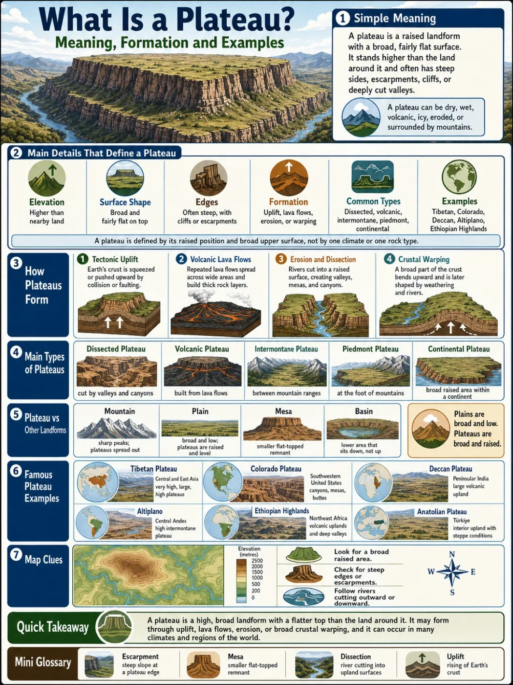
A plateau is a raised landform with a broad, fairly flat surface. It stands higher than the land around it, often with steep sides, escarpments, cliffs, or deeply cut valleys. Some plateaus look like wide high plains. Others are broken by canyons, lava flows, dry basins, river valleys, and mountain rims.
Plateaus matter because they shape rivers, climates, settlement patterns, soils, farming zones, transport routes, and regional maps. A plateau is not just “flat high land.” It is a landform made by uplift, lava, erosion, or a mix of long geologic processes.
Landform Note: A plateau can be high, low, dry, wet, volcanic, eroded, icy, or surrounded by mountains. The shared feature is a raised surface with lower-relief land across the top compared with the slopes around it.
| Feature | What It Means | Why It Matters |
|---|---|---|
| Elevation | A plateau sits higher than nearby land. | Elevation affects temperature, rainfall, rivers, farming, and settlement. |
| Surface Shape | The top is usually broad and fairly flat, though it may be cut by valleys. | This separates plateaus from sharp mountain ranges. |
| Edges | Many plateaus have steep sides, cliffs, escarpments, or canyon walls. | Edges help map readers see where the plateau rises above surrounding land. |
| Formation | Plateaus form through tectonic uplift, lava flows, erosion, or crustal warping. | The origin affects rock type, soil, drainage, and landscape shape. |
| Common Types | Dissected, volcanic, intermontane, piedmont, and continental plateaus. | Types help explain why different plateaus look and behave differently. |
| Examples | Tibetan Plateau, Colorado Plateau, Deccan Plateau, Altiplano, Ethiopian Highlands. | These examples show how plateaus appear in different climate and tectonic settings. |
What Does Plateau Mean in Geography?
In geography, a plateau means an elevated area of land with a wide, relatively level top. The word is often linked with the idea of a tableland, because many plateaus look like raised tables on a landform map.
That simple shape can hide a lot of detail. A plateau may be smooth and open, like a high plain. It may also be carved into mesas, buttes, ravines, canyons, and dry basins. A plateau can even contain mountains, lakes, wetlands, towns, farms, deserts, forests, and glaciers.
The main point is this: a plateau is defined by its raised position and broad upper surface, not by one climate, one rock type, or one country.
Simple Plateau Definition
A plateau is a high, broad landform with a flatter top than the land around it. It usually rises above nearby plains, basins, valleys, or lowlands.
Plateau Meaning in Everyday Terms
Imagine a large area of land pushed upward, then worn down across the top by wind, water, ice, or long exposure. The result may be a raised surface that looks flatter than nearby mountains, but still sits well above surrounding land.
That raised surface is the plateau.
Plateau, Tableland and Highland
The words plateau, tableland, and highland often overlap, but they are not always used in the same way.
- Plateau: A raised landform with a broad, fairly level surface.
- Tableland: A plateau-like landform with a flat, table-shaped top.
- Highland: A broad high-elevation region, often more rugged than a plateau.
A highland may contain plateaus. A plateau may be part of a larger highland region. The terms depend on scale, map use, and local geography.
How a Plateau Looks on the Ground
A plateau does not always look perfectly flat. Many plateaus are only flat when compared with nearby mountains, cliffs, or low plains. On the ground, the surface may rise and fall gently across long distances.
Common surface features include:
- wide upland plains
- dry basins and shallow depressions
- river canyons
- volcanic rock sheets
- grassland, steppe, desert, forest, or tundra cover
- steep margins called escarpments
- isolated mesas and buttes left by erosion
Map Note: On a physical map, a plateau often appears as a broad high area with color shading that stays fairly even across the top, then drops sharply along one or more edges.
Why Plateaus Often Have Steep Edges
Many plateaus rise above nearby lowlands because the crust has been lifted, lava has built up thick rock layers, or softer surrounding rock has worn away. These processes can leave steep outer slopes, cliffs, or escarpments.
The edge of a plateau is often where the landscape changes fast. Rivers may drop into valleys. Roads may climb through passes. Climate and vegetation may also shift with elevation.
Why Some Plateaus Are Cut by Deep Valleys
Rivers do not stop cutting just because land is flat on top. If a plateau rises or if a river has enough energy, water can slice into the plateau surface and create deep valleys or canyons.
This is why some plateaus look smooth from far away but broken when seen in detail. The Colorado Plateau is a clear example: it is an elevated region, yet rivers have cut deep canyons through it.
How Plateaus Form
Plateaus form in several ways. Some are lifted by moving tectonic plates. Some are built by repeated lava flows. Some are shaped when erosion removes softer rock and leaves a harder raised surface behind.
Most large plateaus have a mixed history. Uplift may raise the land, then rivers and weathering reshape it for millions of years.
Tectonic Uplift
Tectonic uplift happens when parts of Earth’s crust rise. This can happen during plate collision, crustal shortening, fault movement, or broad warping of the lithosphere.
When a large region rises and stays relatively level across the top, it can become a plateau. The uplift may also change river flow. Streams that once crossed low land may begin cutting downward as the land rises.
The Tibetan Plateau is often linked with plate collision and uplift. It sits north of the Himalayas and is one of the highest and largest plateau regions on Earth.
Volcanic Lava Flows
A volcanic plateau forms when lava spreads across a wide area and cools into layers of rock. Repeated eruptions can build thick stacks of basalt or other volcanic rocks.
Over time, the surface may become a broad, elevated plain. Rivers, weathering, and later erosion can cut into the rock and reveal its layered structure.
The Deccan Plateau in India and the Columbia Plateau in the northwestern United States are well-known volcanic plateau regions.
Erosion and Dissection
Erosion can both create and reshape plateaus. In some places, erosion removes softer surrounding rock and leaves a harder upland surface. In other places, rivers cut deeply into an already raised plateau.
A dissected plateau is a plateau cut by valleys, canyons, ravines, or drainage channels. The land may still be a plateau, but the surface is no longer simple or smooth.
Crustal Warping and Broad Uplift
Some plateaus form when a large part of the crust bends or swells upward over a broad area. This does not always create sharp mountain peaks. Instead, it can create a raised surface that later becomes shaped by rivers, wind, ice, and weathering.
This kind of uplift can produce a plateau that looks calm on a small map but has a long, complex geologic story beneath it.
| Formation Process | How It Works | Typical Result | Example |
|---|---|---|---|
| Tectonic Uplift | Crust rises because of plate movement, collision, or faulting. | High elevated region, often near mountains. | Tibetan Plateau |
| Volcanic Build-Up | Lava flows spread across wide areas and harden into rock layers. | Broad basalt plateau or lava plateau. | Deccan Plateau, Columbia Plateau |
| River Dissection | Rivers cut down into a raised surface. | Canyons, valleys, mesas, and rugged uplands. | Colorado Plateau |
| Erosional Resistance | Softer nearby rock wears away faster than harder rock. | Raised table-like landform left standing above lower land. | Local tablelands and mesa-like plateau surfaces |
Main Types of Plateaus
Plateaus can be grouped by how they form, where they sit, and what surrounds them. The same plateau may fit more than one category, especially if it has both tectonic and erosional features.
Dissected Plateau
A dissected plateau is a raised plateau surface cut by rivers, streams, or erosion. It may contain canyons, valleys, ridges, mesas, and buttes.
The land can still be high and broad, but the surface is broken. This type is easy to confuse with a mountain region because erosion can make the terrain rugged.
Example: The Colorado Plateau includes famous canyon landscapes shaped by river erosion.
Volcanic Plateau
A volcanic plateau forms from lava flows that spread over wide areas. These flows can build thick layers of rock across a region.
Volcanic plateaus often have basalt bedrock, broad uplands, and river valleys cut into old lava layers.
Example: The Deccan Plateau is linked with vast volcanic rock layers in peninsular India.
Intermontane Plateau
An intermontane plateau sits between mountain ranges. These plateaus are often high because they lie inside or near zones of tectonic uplift.
They may include interior basins, salt lakes, dry valleys, grasslands, and cold high-elevation climates.
Example: The Tibetan Plateau lies between major mountain systems in Asia.
Piedmont Plateau
A piedmont plateau sits at the foot of mountains, with mountains on one side and lower plains or coastal lowlands on the other.
These plateaus often form transition zones between rugged uplands and flatter lowlands.
Example: The Piedmont region of the eastern United States is often described as a plateau-like upland between the Appalachian Mountains and the Atlantic Coastal Plain.
Continental Plateau
A continental plateau is a broad raised area away from active mountain belts. It may be surrounded by lower plains, basins, or older stable land.
These plateaus can cover large areas and may be shaped more by long erosion than by fresh mountain uplift.
Plateau vs Mountain, Plain, Mesa and Basin
People often confuse plateaus with other landforms because the borders are not always sharp. The easiest way to tell them apart is to look at shape, elevation, surface width, and surrounding land.
| Landform | Basic Shape | Main Difference from a Plateau | Simple Rule |
|---|---|---|---|
| Mountain | High, steep, often with peaks or ridges. | A mountain is usually sharper and less broad across the top. | Peaks point up; plateaus spread out. |
| Plain | Broad, low-relief land, often near lower elevation. | A plain is usually not raised sharply above nearby land. | Plains are broad and low; plateaus are broad and raised. |
| Mesa | Flat-topped hill or small tableland with steep sides. | A mesa is smaller than a plateau. | A mesa is like a small remnant of a plateau surface. |
| Butte | Narrow flat-topped or steep-sided landform. | A butte is smaller and more isolated than a mesa or plateau. | Buttes are small; plateaus are regional. |
| Basin | Low area where water or sediment may collect. | A basin is usually lower than surrounding land, while a plateau is raised. | Basins sit down; plateaus stand up. |
Common Mix-Up: A plateau can contain mountains and basins. The larger region may still be a plateau if the general land surface is high and broad.
Is a Plateau Always Flat?
No. A plateau is usually flatter than nearby rugged land, but it does not need to be perfectly flat. Many plateaus have hills, valleys, cliffs, gullies, lava ridges, and river-cut canyons.
The word flat in plateau geography often means low relief across a raised surface, not a smooth floor-like shape.
Can a Plateau Be Higher Than a Mountain?
A plateau region can reach very high elevation, but a mountain is usually judged by its steepness, relief, and peak form. A high plateau may sit above many lower mountains, while still having a broad surface instead of a sharp summit.
This is why elevation alone does not define the landform.
Why Plateaus Matter in Geography
Plateaus affect how landscapes work. Their height, rock type, climate, and drainage patterns can shape large regions.
They Shape Rivers and Drainage
Plateaus often act as high surfaces from which rivers flow outward. Some rivers begin on plateaus. Others cut through plateaus and form deep valleys or canyons.
Plateaus can also contain interior basins, where water does not easily reach the sea. In dry climates, this can lead to salt flats, seasonal lakes, or closed drainage systems.
They Affect Climate
Elevation changes temperature. Higher land is usually cooler than nearby lowlands. A plateau may also affect rainfall if it blocks, lifts, or redirects air masses.
Some plateaus are dry because they sit in rain-shadow zones behind mountains. Others support grasslands, forests, wetlands, or alpine environments, depending on latitude and moisture.
They Influence Human Settlement
People live on many plateaus because the land can offer open space, mineral resources, pasture, farming zones, and cooler climates in warm regions.
Yet plateau life can also bring challenges. Thin air, cold nights, dry conditions, steep access routes, and limited water may affect travel, farming, and city growth.
They Help Explain Regional Boundaries
Plateaus often form natural regions. A plateau may separate river basins, mark a change in climate, or divide lowlands from mountains. This makes plateaus useful in geography, cartography, geology, and education.
Famous Plateau Examples Around the World
Plateaus appear on every continent. Some are high and cold. Some are dry and rocky. Others support farms, forests, cities, or volcanic landscapes.
| Plateau | Location | Approximate Elevation or Scale | Known For |
|---|---|---|---|
| Tibetan Plateau | Central and East Asia | Often described as averaging around 4,500 meters above sea level | Very high elevation, mountain surroundings, major river headwaters |
| Colorado Plateau | Southwestern United States | Roughly 337,000 square kilometers | Canyons, mesas, buttes, and river-cut landscapes |
| Deccan Plateau | Peninsular India | Often described as a broad upland of several hundred meters in elevation | Volcanic rock history, large interior upland, major river systems |
| Altiplano | Central Andes, South America | High intermontane plateau, much of it above 3,000 meters | Andean basins, salt flats, high lakes, dry climates |
| Ethiopian Highlands | Northeast Africa | Large highland plateau region with many areas above 1,500 meters | Deep valleys, volcanic uplands, headwaters, varied climate zones |
| Columbia Plateau | Northwestern United States | Large basalt plateau across parts of Washington, Oregon, and Idaho | Layered lava flows, river valleys, dry interior landscapes |
| Anatolian Plateau | Türkiye | Broad interior upland, often above nearby coastal lowlands | Interior basins, steppe climate zones, mountain margins |
| Mexican Plateau | Northern and central Mexico | High interior plateau between mountain ranges | Large cities, basins, dry uplands, volcanic and tectonic features |
Tibetan Plateau
The Tibetan Plateau is one of Earth’s largest and highest plateau regions. It sits north of the Himalayas and links with major Asian mountain systems.
Its height affects climate, snow cover, glaciers, and river systems. Several major Asian rivers have headwater regions connected with the wider Tibetan highland area.
Colorado Plateau
The Colorado Plateau covers a large part of the American Southwest. It is known for canyons, mesas, buttes, cliffs, and colorful sedimentary rock layers.
Its surface is elevated, but it is strongly dissected by rivers. This makes it one of the clearest examples of how a plateau can be both broad and deeply carved.
Deccan Plateau
The Deccan Plateau covers much of peninsular India. It is linked with ancient volcanic activity and broad upland landscapes.
Several river systems cross or drain parts of the plateau. The region also shows how plateaus can support farming, cities, mineral zones, and varied climates.
Altiplano
The Altiplano is a high plateau in the central Andes. It lies between mountain ranges and includes high basins, lakes, salt flats, and dry upland landscapes.
It is a strong example of an intermontane plateau, because mountains help frame the raised interior surface.
Ethiopian Highlands
The Ethiopian Highlands form a large highland plateau region in Northeast Africa. The landscape includes volcanic uplands, deep valleys, escarpments, and river headwaters.
This region shows that a plateau can be rugged, fertile in places, and deeply shaped by erosion.
Plateaus by Continent
Each continent has plateau regions, but they do not all look the same. Their climate, height, age, and rock type change from place to place.
Asia
Asia has some of the highest and largest plateaus on Earth. The Tibetan Plateau, Iranian Plateau, Anatolian Plateau, Deccan Plateau, and Mongolian Plateau all show different links between uplift, arid basins, volcanic rocks, mountains, and river systems.
Africa
Africa includes broad plateau regions, volcanic highlands, and elevated basins. The Ethiopian Highlands, East African Plateau, and parts of southern Africa show how plateaus can shape drainage, climate, and regional land use.
North America
North America includes the Colorado Plateau, Columbia Plateau, Mexican Plateau, and plateau-like uplands near the Appalachian region. These areas include volcanic surfaces, canyon landscapes, dry basins, and raised interior plains.
South America
South America has the Altiplano in the Andes and broad upland regions such as the Brazilian Highlands. The continent shows strong contrasts between high mountain-framed plateaus and older eroded uplands.
Europe
Europe has smaller plateau regions compared with Asia or Africa, but plateau landscapes still appear in places such as the Central Spanish Plateau, the Massif Central region of France, and uplands across parts of eastern and southeastern Europe.
Australia
Australia includes broad old uplands, tablelands, and plateau surfaces. The landscape is often shaped by long erosion, dry climates, escarpments, and ancient rock foundations.
Antarctica
Antarctica contains a high ice-covered interior plateau. Unlike many rocky plateaus, its surface is shaped by ice sheets, elevation, cold climate, and slow glacial movement.
How to Identify a Plateau on a Map
A plateau can be hard to spot if a map only shows country borders or city names. Physical maps, elevation maps, shaded relief maps, and contour maps make plateaus easier to read.
Look for a Broad Raised Area
Start by looking for a large region that sits higher than nearby land. On elevation maps, it may appear in warmer or darker elevation colors than surrounding plains.
Check the Edges
A plateau often has one or more steep edges. These may appear as close contour lines, shaded slopes, or named escarpments.
Follow the Rivers
Rivers often reveal plateau shape. Some flow outward from the plateau. Others cut into it and create canyons or deep valleys.
Compare It with Nearby Mountains
If the land is high but broad, it may be a plateau. If it rises into narrow ridges and peaks, it may be a mountain range. Many real regions contain both, so the map scale matters.
Elevation Note: There is no single elevation that every plateau must reach. A plateau is raised compared with nearby land. That means a low plateau can still be a plateau if it stands above its surroundings.
Common Misconceptions About Plateaus
A Plateau Is Not Always a Desert
Many famous plateaus are dry, but dryness is not part of the definition. Plateaus can have grassland, forest, farmland, tundra, wetlands, or ice cover.
A Plateau Is Not Always Empty or Remote
Some plateaus contain major cities, towns, roads, farms, and cultural regions. The Mexican Plateau and Deccan Plateau both show how people can live across broad upland regions.
A Plateau Is Not Just a Flat Mountain
A mountain is usually defined by steep relief and peak form. A plateau is defined by broad elevation and a raised surface. They can occur near each other, but they are not the same landform.
A Plateau Can Be Very Old or Still Changing
Some plateau surfaces are ancient and heavily worn. Others are still shaped by uplift, river erosion, volcanic history, climate, and weathering. Plateaus are not frozen in time.
Mini Glossary of Plateau Terms
| Term | Meaning | Plateau Context |
|---|---|---|
| Escarpment | A steep slope or cliff marking a sharp change in elevation. | Often found along plateau edges. |
| Basin | A lower area where water or sediment may collect. | Some plateaus contain interior basins. |
| Dissection | Cutting of land by rivers, streams, and erosion. | Creates valleys and canyons within raised plateau surfaces. |
| Mesa | A smaller flat-topped landform with steep sides. | Often forms when erosion breaks down a plateau surface. |
| Butte | A small, isolated steep-sided landform. | Can be a remnant of a former mesa or plateau surface. |
| Tableland | A broad flat-topped upland. | Often used as another word for plateau. |
| Uplift | Rising of Earth’s crust. | One of the main ways plateaus form. |
| Rain Shadow | A dry zone on the leeward side of mountains. | Some plateaus are dry because nearby mountains block moist air. |
FAQ
What is a plateau in simple words?
A plateau is a raised area of land with a broad, fairly flat top. It stands higher than nearby land and may have steep sides, cliffs, valleys, or escarpments.
How is a plateau formed?
A plateau can form when Earth’s crust is lifted, when lava flows build thick rock layers, or when erosion leaves a raised surface behind. Many large plateaus form through more than one process.
Is a plateau the same as a mountain?
No. A mountain usually has steep slopes and peaks. A plateau is broad and raised, with a flatter surface across the top. Some plateau regions may contain mountains, but the landforms are not the same.
Can a plateau have rivers?
Yes. Many plateaus have rivers. Some rivers begin on plateaus, while others cut through them and form deep valleys or canyons.
What are some famous plateaus?
Famous plateau regions include the Tibetan Plateau in Asia, the Colorado Plateau in North America, the Deccan Plateau in India, the Altiplano in South America, and the Ethiopian Highlands in Africa.
Is every plateau high above sea level?
No. A plateau must be raised compared with nearby land, but it does not need to reach one fixed elevation above sea level. Local relief matters more than a single height number.