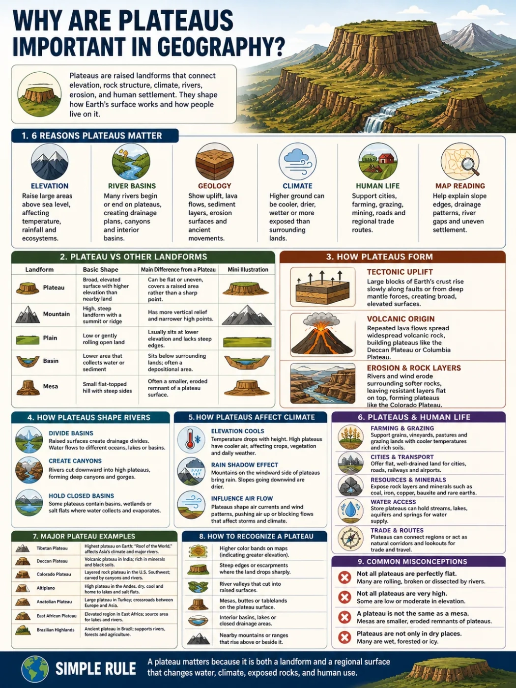
Plateaus are important in geography because they show how elevation, rock structure, climate, rivers, erosion and human settlement work together on Earth’s surface. A plateau is not just “flat high land.” It is a raised landform that can shape drainage patterns, divide river basins, affect weather, support farming and mining, and help geographers read the history of a region.
Some plateaus rise between mountain ranges. Some spread across dry interiors. Others form from lava flows, uplifted crust or long erosion. Their size can range from small local tablelands to vast high regions such as the Tibetan Plateau, the Deccan Plateau, the Colorado Plateau and the East African Plateau.
Geography Note: A plateau helps explain both shape and process. Its surface may look calm, but its edges, rivers, rocks and height often record long periods of uplift, lava flow, erosion or crustal movement.
| Geographic Role | Why It Matters | Common Example |
|---|---|---|
| Elevation | Plateaus raise large areas above nearby lowlands, changing temperature, rainfall and settlement patterns. | Tibetan Plateau, Altiplano |
| River Basins | Many rivers begin on plateaus or cut through them, forming valleys, canyons and drainage divides. | Colorado Plateau, Brazilian Highlands |
| Geology | Plateaus can show uplift, lava flows, sedimentary layers, erosion surfaces and crustal movement. | Deccan Plateau, Columbia Plateau |
| Climate | Higher ground can be cooler, drier, windier or more exposed than surrounding plains. | East African Plateau, Iranian Plateau |
| Human Life | Plateaus can support cities, farming, grazing, mining, roads and regional trade routes. | Mexican Plateau, Anatolian Plateau |
| Map Reading | Plateaus help explain why regions have steep edges, broad interiors, river gaps and uneven settlement. | Colorado Plateau, Ethiopian Highlands |
What Makes a Plateau Different from Other Landforms?
A plateau is a raised area with a fairly broad surface. It may be flat, gently rolling or broken by valleys. What matters most is its position: it sits higher than nearby land and often has at least one steep side, slope or escarpment.
This makes plateaus different from mountains, plains and basins, even when they sit near one another.
| Landform | Basic Shape | Main Difference from a Plateau |
|---|---|---|
| Plateau | Raised, broad surface with higher elevation than nearby land | Can be flat or uneven, but covers a raised area rather than a sharp peak |
| Mountain | High, steep landform with a summit or ridge | Has more vertical relief and narrower high points |
| Plain | Low or gently rolling open land | Usually sits at lower elevation and lacks steep raised edges |
| Basin | Lower area that collects water or sediment | Sits below surrounding land, while a plateau rises above it |
| Mesa | Small flat-topped hill with steep sides | Often a smaller eroded remnant of a plateau surface |
A simple rule helps: a plateau is about a raised surface, while a mountain is about a high peak, a basin is about a low collecting area, and a plain is about broad low relief.
Plateaus Record How Earth’s Surface Changes
Plateaus are useful to geographers because they preserve evidence of how land rises, breaks, cools, erodes and drains. Their shape can point to older rock layers, volcanic activity, tectonic uplift or long periods of surface wear.
Tectonic Uplift
Some plateaus form when large blocks of crust rise. This can happen near mountain belts or within broad highland regions. The Tibetan Plateau is often described as the highest and largest plateau on Earth, with much of its surface lying over about 4,000 meters above sea level.
That height affects more than the land itself. It also affects air flow, river sources, glaciers and nearby lowland climates.
Volcanic Origin
Other plateaus form from repeated lava flows. When lava spreads over wide areas and hardens in layers, it can create a broad volcanic tableland. The Deccan Plateau in India and the Columbia Plateau in North America are well-known examples of this type.
These places help explain how lava can build land on a regional scale, not only around cone-shaped volcanoes.
Erosion and Rock Layers
Some plateaus are shaped by erosion after uplift. Rivers cut into the raised surface, leaving canyons, cliffs, mesas and buttes. The Colorado Plateau is a clear example, where layered rocks and river incision show long Earth surface history in exposed form.
Landform Note: A plateau can look simple from above, but its edges often tell the story. Cliffs, canyons and escarpments show where rivers and weathering have cut into the raised surface.
How Plateaus Shape Rivers and Drainage
Plateaus often sit high enough to act as water towers, drainage divides or headwater zones. Rain, snowmelt and groundwater from plateau areas can feed rivers that flow into lower basins.
This makes plateaus important for reading river maps. A river may begin on a high plateau, cut through its edge, then cross plains far away. In dry regions, the plateau may also hold seasonal streams, closed basins or salt flats.
Plateaus Can Divide River Basins
Because plateaus are raised, they can separate drainage systems. Water falling on one side may flow toward one sea, lake or basin, while water on the other side follows a different route.
This is why plateaus often appear near watersheds and highland divides on physical maps.
Plateaus Can Create Canyons
When rivers cut downward into a raised plateau, they can form deep valleys or canyons. This happens when the land remains high while flowing water keeps removing rock and sediment.
The Grand Canyon is tied to this kind of process on the Colorado Plateau. The canyon is not the plateau itself; it is a river-cut feature within a larger raised region.
Plateaus Can Hold Closed Basins
Some high plateaus include basins where water does not reach the sea. Water may collect in lakes, wetlands or salt flats, then evaporate. These landscapes are common in dry interior plateaus.
The Altiplano of South America includes high basins, lakes and salt flats between the Andes ranges. Its elevation and interior position shape both water flow and climate.
How Plateaus Affect Climate
Elevation changes climate. A plateau can be cooler than nearby lowlands because temperature usually drops with height. It can also be drier, windier or more exposed, depending on its location and nearby mountains.
Elevation Cools the Surface
High plateaus often have cooler air than surrounding plains. This affects vegetation, farming seasons and settlement. Even in warm latitude zones, a high plateau may have mild days, cold nights or frost risk.
Mountains and Plateaus Work Together
Plateaus near mountain ranges often sit in rain-shadow zones. Moist air may drop rain on one side of a mountain barrier, leaving the plateau interior drier.
This helps explain why some plateaus support grassland, steppe, scrubland or desert-like terrain rather than dense forest.
Large Plateaus Can Influence Air Flow
Very large high plateaus can affect regional wind and pressure patterns. The Tibetan Plateau is often linked with broad Asian climate systems because it forms a huge elevated surface that heats and cools differently from nearby lowlands.
For geography, this is one reason plateaus are studied as climate-shaping landforms, not just as surface shapes.
Elevation Note: Two places at the same latitude can feel very different if one sits on a plateau. Height can change temperature, growing season, rainfall pattern and daily weather.
Why Plateaus Matter for People and Settlement
Plateaus affect where people live, farm, graze animals, build roads and use natural resources. They can offer open land above flood-prone lowlands, but they may also bring thin soils, cold nights, steep edges or water limits.
Farming and Grazing
Some plateaus support grain fields, vineyards, grazing land or mixed farming. Soil depth, rainfall and temperature decide what is possible. Volcanic plateaus may have fertile soils in some areas, while dry plateaus may be better suited to grazing than crop farming.
Not every plateau is easy to farm. Height, slope, frost and water access can limit land use.
Cities and Transport
Many cities sit on or near plateaus because raised land can offer flatter building ground than mountains and better drainage than some lowlands. Roads and railways may follow plateau surfaces where slopes are gentle, then cross escarpments through passes, valleys or cuttings.
Plateaus can also slow travel when their edges are steep. A route that looks short on a map may be harder because of elevation change.
Minerals, Stone and Energy
Plateaus often expose rock layers or contain old volcanic and sedimentary formations. This can make them important for minerals, building stone, groundwater storage or energy resources.
Geographers study this carefully because land use depends on both surface shape and underground structure.
Plateaus Help Explain Regional Identity
A plateau can define the character of a region. It may shape climate, farming, language areas, transport routes and settlement spacing. The Anatolian Plateau, Mexican Plateau, Iranian Plateau and Ethiopian Highlands all show how raised interiors can organize large parts of a country or region.
In geography, this matters because regions are not only political units. They are also shaped by landforms, water systems, access routes and elevation.
Plateaus as Interior Regions
Many plateaus form the inland core of a country or continent. They may sit away from coastlines and have fewer direct sea routes. This can affect settlement density, trade paths and the placement of cities.
Plateaus as Cultural Landscapes
People adapt to plateau conditions through building styles, crops, livestock choices, seasonal movement and water use. Geography treats these choices as part of the landscape, not separate from it.
The land does not decide everything, but it does set limits and options.
Major Plateau Examples and What They Show
Different plateaus teach different geography lessons. Some are known for height, some for lava flows, some for river carving, and some for large human settlement areas.
| Plateau | Region | What It Shows |
|---|---|---|
| Tibetan Plateau | Central Asia | Extreme elevation, tectonic uplift, major river sources and regional climate effects |
| Deccan Plateau | India | Volcanic rock layers, broad interior highland and major river systems |
| Colorado Plateau | Southwestern United States | Sedimentary rock layers, canyons, mesas, buttes and river erosion |
| Altiplano | Andes, South America | High basins, salt flats, lakes and dry mountain-plateau climate |
| Anatolian Plateau | Türkiye | Interior highland, basins, steppe climate and links between mountains and plains |
| East African Plateau | Eastern Africa | Highland surfaces, rift valleys, lakes and varied tropical elevation zones |
| Brazilian Highlands | Eastern and central Brazil | Old uplands, river basins, escarpments and broad regional relief |
How to Recognize a Plateau on a Map
A plateau may not always look flat on a physical map. The easiest clue is a broad area of higher elevation compared with nearby lowlands.
Look for these map signs:
- Higher color bands on elevation maps, often surrounded by lower colors.
- Steep edges, escarpments or sharp changes in contour spacing.
- River valleys cutting into a raised surface.
- Flat-topped hills, mesas or buttes near eroded plateau margins.
- Interior basins, lakes or salt flats in dry highland regions.
- Mountain borders around or near a raised interior surface.
On a contour map, a plateau may show wide spacing on the surface and tighter spacing near the edge. That means the top is relatively open, while the sides drop more sharply.
Common Misconceptions About Plateaus
All Plateaus Are Perfectly Flat
Many plateaus are not perfectly flat. They may include hills, valleys, lava fields, basins, canyons or eroded surfaces. “Flat” usually means broad and less peaked than mountains, not smooth like a table.
All Plateaus Are Very High
Some plateaus are extremely high, but height alone does not define them. A plateau must be raised compared with nearby land. A lower plateau can still be a plateau if it has a broad elevated surface and clear relief from its surroundings.
A Plateau and a Mesa Are the Same
A mesa is usually smaller. It is often a flat-topped remnant left after erosion cuts away a larger plateau surface. In simple terms, a mesa can be part of a plateau landscape, but it is not the same landform at regional scale.
Plateaus Are Only Found in Dry Places
Dry plateaus are common, but plateaus also occur in temperate, tropical, volcanic and high mountain regions. Climate depends on latitude, elevation, nearby seas, mountains and wind patterns.
Why Plateaus Are Important for Geography Students
Plateaus help students connect several geography topics in one landform. A single plateau can explain relief, rock type, river flow, climate, settlement, farming and map interpretation.
They are useful because they sit between simple categories. A plateau is not a mountain, not a plain, not a basin, and not just a high flat area. It is a raised landscape that often links all of those features.
They Connect Physical Geography Topics
- Landform formation
- Tectonic uplift
- Volcanic activity
- River erosion
- Drainage basins
- Climate and elevation
- Soil and vegetation patterns
They Connect Human Geography Topics
- Settlement location
- Farming and grazing
- Transport routes
- Water access
- Mining and resources
- Regional land use
This is why plateaus appear often in school geography, atlases, landform glossaries and regional studies.
Simple Rule for Understanding Plateau Importance
A plateau matters because it is both a landform and a regional surface. It affects what water does, where people live, how climate feels, what rocks are exposed and how nearby mountains, plains and basins connect.
When a map shows a wide raised area, the question is not only “How high is it?” The better question is: What does this elevated surface change around it?
FAQ
Why are plateaus important in geography?
Plateaus are important because they shape elevation, climate, river flow, erosion, settlement and land use. They help geographers understand how raised land affects both natural systems and human activity.
How does a plateau affect rivers?
A plateau can act as a source area, drainage divide or raised surface that rivers cut through. Rivers may begin on a plateau, flow away from it, or carve deep valleys and canyons into its edges.
Are plateaus always high and flat?
No. Many plateaus are high, but height is relative to nearby land. They also do not have to be perfectly flat. A plateau may include hills, basins, valleys, cliffs, mesas and river-cut landscapes.
Why do people live on plateaus?
People live on plateaus when the land offers usable space, water access, farming conditions, grazing land, transport routes or resources. Some plateaus support large cities and farmland, while others are limited by dryness, cold or steep edges.
What is the difference between a plateau and a mountain?
A plateau is a broad raised surface, while a mountain usually has a steep shape, a summit or a ridge. Plateaus can sit near mountains, but their main feature is area and elevation rather than a sharp peak.