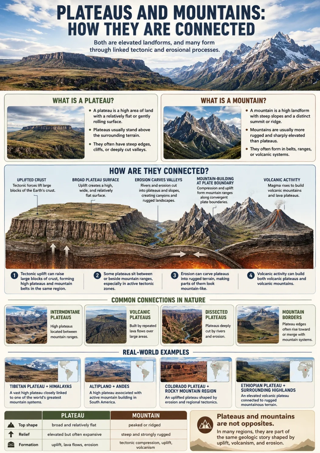
Plateaus and mountains are connected because both are elevated landforms, both can rise through tectonic forces, and both can shape climate, rivers, drainage basins, and human settlement. The main difference is shape: a mountain usually rises into a peak, ridge, or steep mass, while a plateau is a broad high surface with flatter or gently rolling land on top.
A simple way to remember the link is this: mountains often form the high edges and uplift zones around plateaus, while plateaus often act as broad raised platforms between or beside mountain belts.
Landform Note: A plateau can stand higher than many mountains in absolute elevation, but still look flatter on a map. Elevation tells how high land sits above sea level. Relief tells how much the land rises or falls compared with nearby ground.
Short Answer: How Are Plateaus and Mountains Connected?
Plateaus and mountains are connected through uplift, erosion, volcanic activity, river cutting, and regional landform patterns. In many parts of the world, a plateau does not sit alone. It may be bordered by mountains, crossed by ridges, cut by rivers, or lifted as part of the same crustal movement that forms nearby ranges.
Some plateaus form when large areas of crust rise without being folded into sharp peaks. Others form when lava spreads across wide areas and hardens into layers. Mountains, by contrast, usually show stronger local relief: steep slopes, narrow ridges, summits, valleys, and exposed rock faces.
The connection becomes clear in places like the Tibetan Plateau, the Altiplano, the Colorado Plateau, the Ethiopian Highlands, and the Deccan Plateau. These are not just “flat highlands.” They are raised landscapes shaped by nearby mountains, deep valleys, escarpments, basins, and long river systems.
Plateaus vs Mountains: Main Differences
| Feature | Plateau | Mountain | How They Connect |
|---|---|---|---|
| Main Shape | Broad, elevated, often flat or gently rolling on top | Steep, high, often with a summit, ridge, or rugged crest | Mountain uplift can raise broad plateau surfaces nearby |
| Relief | Low to moderate relief across the top, sharper relief at edges | High local relief from base to summit | Plateau edges may look mountain-like when cut by erosion |
| Common Formation | Tectonic uplift, lava flows, erosion of surrounding land | Folding, faulting, volcanic growth, uplift, erosion | Both can come from the same deep crustal forces |
| Map Pattern | Large high area with flatter interior and steep outer margins | Clustered peaks, ridges, valleys, and close contour lines | Plateaus may sit behind or between mountain ranges |
| River Pattern | Rivers may cut canyons or drain into basins | Rivers often begin on slopes or in high valleys | Both can act as headwater zones and drainage divides |
| Climate Effect | High elevation can make climates cooler or drier | Slopes can force air upward, shaping rainfall and rain shadows | Mountain barriers often influence plateau climates |
What Makes a Plateau Different from a Mountain?
A plateau is defined less by height alone and more by its surface form. It is a raised landform with a broad top. Some plateaus have steep sides called escarpments. Others fade into hills, basins, or mountain foothills.
A mountain is defined more by relief and slope. It rises sharply above nearby land and often has a peak, crest, ridge, or chain of summits. A mountain does not need to be isolated. Many mountains form ranges, belts, or highland systems.
Elevation Is Not the Whole Story
One common mistake is to think that a mountain is always higher than a plateau. That is not always true. The Tibetan Plateau, for example, sits at very high average elevation, yet much of it is described as a plateau because the land spreads across a wide raised surface rather than forming one narrow summit.
A lower mountain can still be a mountain if it rises steeply above its surroundings. A high plateau can still be a plateau if its upper surface is broad and relatively even.
Relief Explains the Visual Difference
Relief means the difference in height between nearby high and low points. Mountains usually have strong local relief. Plateaus may have high elevation but lower relief across their upper surface.
This is why some plateaus look calm from above but rugged from the side. Their tops may be broad, yet their edges can drop sharply into valleys, plains, or basins.
Elevation Note: A landform can be high without being a mountain. The shape of the surface, the steepness of its sides, and the pattern of nearby valleys matter as much as elevation.
How Plateaus and Mountains Form Together
Plateaus and mountains often share the same geologic setting. The difference is how the land responds after uplift, lava flow, faulting, erosion, or crustal compression.
Tectonic Uplift
Tectonic uplift raises large areas of Earth’s crust. If the uplift creates steep folds, faults, and narrow ridges, the result may be a mountain belt. If a broad area rises as a wider block or high surface, it may become a tectonic plateau.
This is one reason mountain belts and plateaus often appear near each other. A collision zone can build mountains along one edge while lifting a high plateau behind it.
Crustal Thickening and High Plateaus
In some regions, tectonic compression thickens the crust. Thickened crust can support very high terrain. This helps explain why some of the world’s highest plateaus sit near major mountain systems.
The Tibetan Plateau is the best-known example. It is closely linked with the Himalaya, yet it is not the same landform as the Himalayan mountain front. The plateau is a broad high region; the Himalaya form a steep mountain belt along its southern side.
Volcanic Plateaus and Volcanic Mountains
Volcanic activity can create both plateaus and mountains, but in different ways.
- Volcanic plateaus form when lava spreads across wide areas in repeated flows.
- Volcanic mountains form when eruptions build cones, domes, or steep volcanic slopes.
- Some volcanic regions include both wide lava fields and volcanic peaks.
The Deccan Plateau in India and the Columbia Plateau in the northwestern United States are often described as lava-related plateau landscapes. They are broad surfaces shaped by volcanic flows and later erosion, not single volcanic cones.
Erosion and Dissection
Erosion can make a plateau look more like a mountain region. Rivers cut into elevated rock layers. Over time, valleys, canyons, mesas, buttes, ridges, and isolated high blocks can appear.
This process is called dissection. A dissected plateau may still be a plateau by origin and regional form, even if parts of it look rugged.
Why Mountains Often Border Plateaus
Many plateaus sit beside or behind mountain ranges because the same forces that build mountains can also lift nearby land. Mountains may mark the steepest edge of a high region, while the plateau forms the broader raised interior.
This pattern appears in several ways:
- Foreland and interior uplift: land behind a mountain front may rise as a broad highland.
- Fault-bounded edges: steep plateau margins may form where blocks of crust move.
- Erosional edges: rivers and weathering may cut steep scarps along plateau sides.
- Volcanic build-up: lava layers may create a raised surface near older mountains.
The edge between a plateau and a mountain range is not always sharp. Foothills, basins, ridges, escarpments, and high valleys can form a transition zone.
Map Reading: How to See the Connection
On a physical map, mountains and plateaus can both appear as high ground. The difference becomes clearer when reading shape, contour spacing, rivers, and edges.
How a Plateau Looks on a Map
A plateau often appears as a large elevated area with a broad top. Contour lines may be spaced farther apart across the interior, then become closer at the edges where the land drops.
Look for these clues:
- Wide high surface rather than one narrow summit
- Steep outer margin or escarpment on one or more sides
- Rivers cutting deep valleys into the raised surface
- Basins, mesas, or canyons inside the plateau region
- Nearby mountain ranges forming a rim or boundary
How a Mountain Looks on a Map
A mountain usually shows tighter contour lines, a summit area, and strong local relief. In a range, the map may show a chain of peaks, ridges, passes, valleys, and steep drainage lines.
Mountains are easier to identify where land rises quickly from surrounding lowlands. Plateaus require more careful reading because the top can be wide and less jagged.
Map Note: When a high area looks flat across a wide distance, check the edges. A steep drop around a broad surface is often a plateau clue. A tight cluster of summits and ridges usually points toward mountains.
Rivers, Basins, and Drainage Patterns
Plateaus and mountains both affect where rivers begin, how they flow, and how deep they cut into the land. Their connection is especially clear in drainage patterns.
Plateaus as River-Cut Landscapes
A plateau can act like a raised table that rivers slice through. The water may carve canyons, valleys, gorges, and dry washes, depending on climate and rock type.
The Colorado Plateau is a strong example of this pattern. Its broad raised surface has been cut by the Colorado River system and many smaller tributaries. The result is a plateau landscape with deep canyons and high cliffs.
Mountains as Headwater Zones
Mountains often collect snow, rain, and runoff. Rivers may begin in mountain valleys, then flow across or along plateaus. In other regions, rivers rise on plateaus and later cut toward lower basins.
This creates a close connection between mountain slopes, plateau surfaces, and river basins. A river may begin in a mountain belt, cross a high plateau, then drop through an escarpment toward a plain.
Closed Basins on High Plateaus
Some plateaus contain internal basins where water does not easily reach the sea. In dry climates, this can produce salt flats, seasonal lakes, or wide basin floors. The Altiplano of the central Andes includes high basins and lakes within a plateau-like region between mountain ranges.
Climate Links Between Plateaus and Mountains
High elevation affects temperature. In general, higher land is cooler than nearby lowland areas. This is true for both mountains and plateaus, though the pattern varies with latitude, wind, slope, and moisture.
Mountains also shape rainfall by forcing moist air upward. As air rises, it cools and may release moisture on windward slopes. The leeward side can become drier. This rain shadow effect can influence plateau climates behind mountain barriers.
Plateaus may be:
- Cold and dry, especially at high elevation or far from oceans
- Seasonally wet, where monsoon or mountain rainfall reaches the highland
- Volcanic and fertile, where weathered lava or ash supports soils
- Dissected and arid, where rivers cut deep valleys but rainfall is limited
Climate helps explain why plateau landscapes can support grasslands, steppe, shrubland, forests, farms, grazing areas, cities, or sparsely settled highlands.
Examples of Plateaus Connected to Mountains
| Plateau or Highland Region | Connected Mountains or Uplands | Main Connection | Geography Pattern |
|---|---|---|---|
| Tibetan Plateau | Himalaya, Kunlun, Karakoram, and other ranges | High tectonic uplift linked with mountain building | Very high plateau bordered by major mountain systems |
| Altiplano | Central Andes | High basin-and-plateau region between Andean ranges | Elevated interior with basins, lakes, volcanoes, and ridges |
| Colorado Plateau | Rocky Mountains and surrounding uplands | Raised plateau cut by rivers and canyons | Broad high surface with deep river incision |
| Ethiopian Highlands | East African highlands and rift margins | Volcanic uplift and erosion shaped high plateau terrain | Highlands, escarpments, deep valleys, and river headwaters |
| Deccan Plateau | Western Ghats and Eastern Ghats | Lava-built plateau bordered by escarpments and uplands | Broad peninsular plateau with raised margins |
| Columbia Plateau | Cascade Range and Rocky Mountain region | Layered lava plateau later shaped by rivers and erosion | Basaltic plateau with canyons, coulees, and river valleys |
The Tibetan Plateau and the Himalaya
The Tibetan Plateau shows one of the clearest connections between plateaus and mountains. It is often described as the highest and largest plateau region on Earth, with much of its surface lying roughly above 4,000 meters. Its southern edge meets the Himalaya, where some of the world’s highest peaks rise.
The key point is that the plateau and the mountain range are related, but not identical. The Himalaya form a steep mountain front. The Tibetan Plateau is the broad elevated region behind that front.
This difference matters in geography. A map that only labels high elevation may make both areas look similar. A landform reading shows two connected but different shapes: sharp mountain relief along the margin and broad highland surface across the plateau interior.
The Altiplano and the Andes
The Altiplano is a high plateau region in the central Andes, mainly associated with Bolivia and Peru, with extensions toward Chile and Argentina depending on how the region is defined. It lies between Andean ranges rather than beside one simple mountain wall.
This makes it a useful example of a plateau enclosed by mountains. The land is high, but much of the surface includes basins, plains, salt flats, lakes, volcanic areas, and settled highland zones.
The Altiplano also shows why a plateau is not always flat like a table. Many plateaus are uneven. They can include hills, ridges, basins, and volcanic cones while still being part of a broader raised landform.
The Colorado Plateau and the Rocky Mountain Region
The Colorado Plateau is known for raised sedimentary rock layers, canyons, mesas, buttes, cliffs, and river-cut valleys. It sits in the American Southwest and connects geographically with nearby mountain and basin regions.
Its landscape helps explain a common mix-up. A deeply cut plateau can look mountainous because its canyons and cliffs create steep relief. Yet the larger landform is still a plateau because the regional surface is a broad uplifted block rather than a single mountain range.
Here, rivers do much of the visible work. They cut into the raised surface and expose layered rock. The plateau-mountain connection is not only about uplift; it is also about how water reshapes high land over time.
Escarpments: The Edge Between Plateau and Lowland
An escarpment is a steep slope or cliff-like edge that separates higher land from lower land. Many plateaus have escarpments along one or more sides. These edges can make a plateau look like a wall of mountains from the surrounding lowlands.
Escarpments form in several ways. They may reflect faulting, erosion, resistant rock layers, or the edge of a lava flow province. In map reading, an escarpment often marks the boundary where a plateau drops into a plain, basin, or coastal lowland.
This is one reason people may confuse plateau margins with mountain ranges. The edge can be steep and high, but the land behind it may be a broad tableland.
Can a Mountain Be on a Plateau?
Yes. Mountains can rise from a plateau surface. A high plateau may contain volcanic cones, folded ridges, fault-block mountains, isolated peaks, or older eroded ranges.
This creates layered geography:
- The plateau is the broad raised base.
- The mountain is a sharper rise on or near that base.
- The valley is the lower cut between ridges, peaks, or plateau blocks.
- The basin is a lower area that collects drainage or sediment.
This is why “highland” can be a useful general word. A highland may include plateaus, mountains, hills, valleys, and basins. A plateau is more specific than highland because it points to a broad raised surface.
Can a Plateau Become Mountainous?
A plateau can become rugged through erosion, river cutting, faulting, or volcanic activity. This does not always turn it into a mountain range. It may become a dissected plateau, meaning the original high surface has been cut into valleys and smaller high remnants.
Over long periods, erosion can break a plateau into mesas, buttes, ridges, scarps, and canyon walls. From the ground, these features may feel mountain-like. From a regional map view, the plateau origin may still be clear.
Why the Connection Matters in Geography
The plateau-mountain connection helps explain how landscapes work as systems. Mountains, plateaus, rivers, basins, and plains are not separate pieces placed randomly on Earth’s surface. They often form in linked patterns.
This connection helps explain:
- Why many major rivers begin in highlands
- Why some plateaus are dry even when mountains nearby receive rain or snow
- Why steep escarpments can border broad, flatter interiors
- Why high elevation does not always mean a landform is a mountain
- Why some plateau regions contain cities, farms, grazing lands, and transport routes
For human settlement, plateaus can offer broad high surfaces that are easier to cross or build on than steep mountain slopes. But elevation, cold, thin air, limited water, or deep river valleys can still make travel and settlement difficult in some plateau regions.
Common Mix-Ups Between Plateaus and Mountains
Mix-Up 1: “High Land Means Mountain”
High land is not always mountain land. A plateau can be very high if it covers a broad raised surface. The question is not only “How high is it?” but also “What shape does the land have?”
Mix-Up 2: “Flat Means Low”
Flat or gently rolling land can sit at high elevation. Some plateaus are broad and relatively even across the top, yet they stand far above nearby lowlands.
Mix-Up 3: “Canyons Mean Mountains”
Canyons often cut into plateaus. Steep canyon walls can look like mountain terrain, but the surrounding landform may still be a raised plateau.
Mix-Up 4: “Plateaus Have No Peaks”
Plateaus can contain peaks, hills, ridges, and volcanic cones. The presence of smaller mountains does not erase the plateau setting if the wider landform is a broad elevated surface.
Simple Rule for Remembering the Difference
Use this rule: a mountain rises to a high point; a plateau rises as a high area.
That rule is not perfect for every landscape, but it helps in most map-reading situations. Mountains are about steep relief and summits. Plateaus are about broad elevation and raised surfaces.
Related Terms Often Confused with Plateaus and Mountains
| Term | Basic Meaning | How It Relates to Plateaus and Mountains |
|---|---|---|
| Highland | A broad term for elevated land | Can include plateaus, mountains, hills, and valleys |
| Tableland | A raised area with a broad, flatter top | Often used as another word for plateau |
| Escarpment | A steep slope or edge | Often forms the side of a plateau or highland |
| Mesa | A smaller flat-topped highland with steep sides | Often forms from erosion of a plateau surface |
| Butte | A smaller isolated hill with steep sides and a narrow top | May be a remnant of a dissected plateau |
| Basin | A lower area that collects sediment or drainage | Can sit within or beside plateau and mountain regions |
| Range | A chain or group of mountains | May border, cross, or rise from a plateau |
Mini FAQ
Are plateaus and mountains the same thing?
No. Plateaus and mountains are both elevated landforms, but they have different shapes. A plateau is a broad raised surface, while a mountain usually has steeper slopes, stronger local relief, and a summit or ridge.
How are plateaus and mountains connected?
They are connected through uplift, erosion, volcanic activity, river cutting, and regional landform patterns. Mountains may border plateaus, rise from them, or form during the same tectonic processes that lift broad plateau surfaces.
Can a plateau be higher than a mountain?
Yes. A plateau can sit at very high elevation while still having a broad, relatively even surface. A mountain is defined more by steep relief and summit form than by elevation alone.
Why do some plateaus look like mountains?
Some plateaus look mountainous because rivers, faults, and erosion cut them into canyons, ridges, mesas, and steep escarpments. The larger landform may still be a plateau even when parts of it look rugged.
What is the easiest way to tell a plateau from a mountain on a map?
Look at the shape and contour pattern. A plateau usually appears as a wide high area with a broader top and steep edges. A mountain usually shows tighter contour lines around peaks, ridges, and steep slopes.