Plateau Type
An intermontane plateau is a high, broad tableland that sits between mountain ranges. It is not just “high land.” Its shape, height, climate, rivers, and human use are all shaped by the mountains around it.
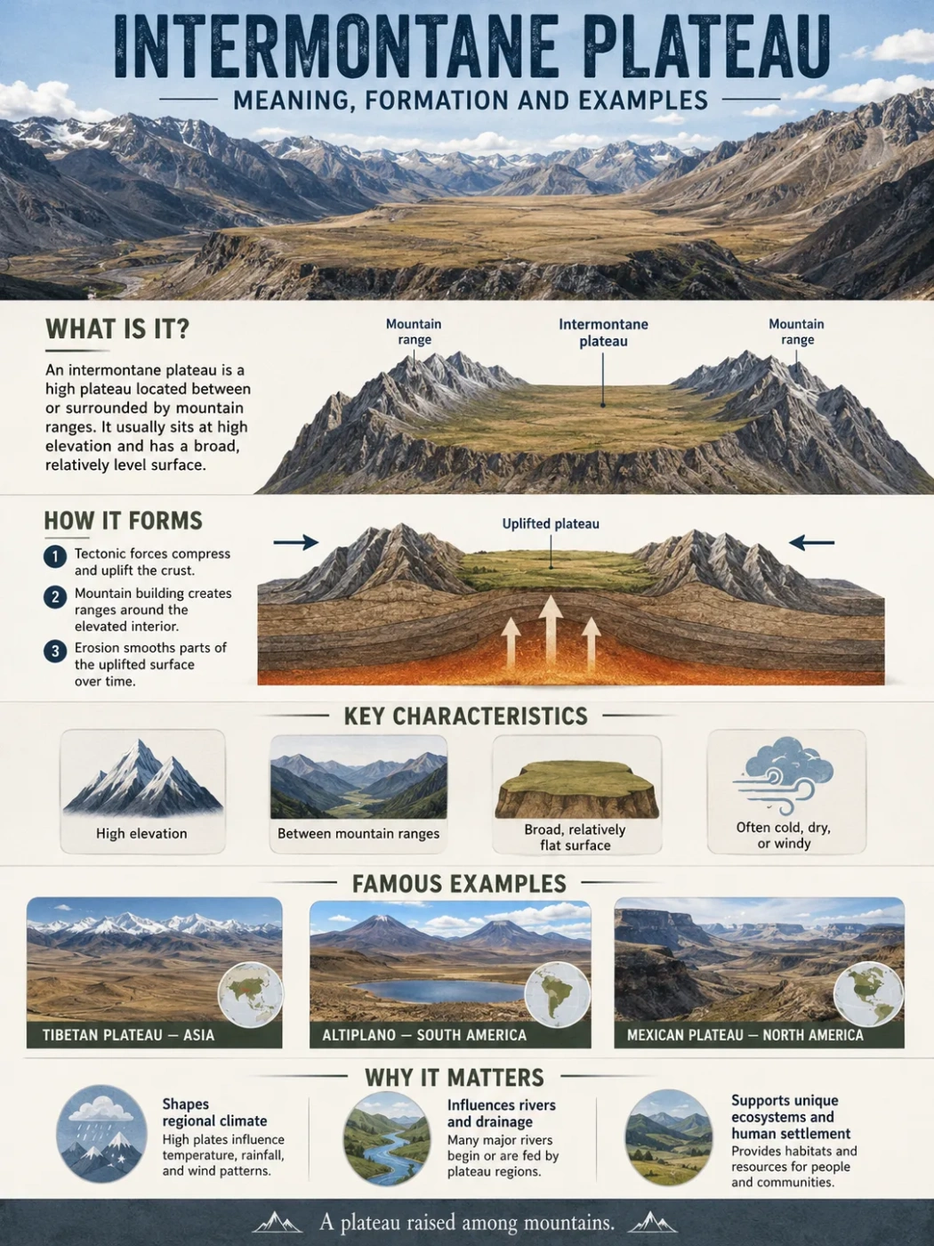
An intermontane plateau is a plateau located among, between, or partly enclosed by mountain ranges. The word comes from “inter” meaning between and “montane” meaning mountain-related. In simple geography terms, it is a highland surface inside a mountain system.
Many of the best-known examples sit inside large fold mountain belts. The Tibetan Plateau lies between major Asian mountain ranges, while the Altiplano lies between branches of the Andes in South America. These places show why intermontane plateaus matter: they affect climate, river sources, settlement, farming, transport, and map patterns over very large regions.
| Feature | Typical Description |
|---|---|
| Landform Type | High plateau or tableland set between mountain ranges |
| Common Setting | Inside large mountain belts, folded ranges, or tectonically active highlands |
| Usual Origin | Tectonic uplift, crustal thickening, faulting, basin filling, or a mix of these processes |
| Elevation | Often high, but the exact height varies widely by region |
| Landscape Pattern | Broad uplands, basins, valleys, escarpments, lakes, dry plains, or river-cut surfaces |
| Well-Known Examples | Tibetan Plateau, Altiplano, Iranian Plateau, Mexican Plateau, Colorado Plateau in some classifications |
Geography Note
“Intermontane” describes position. It tells where the plateau sits: within or between mountains. It does not always tell the full rock type, climate, age, or exact formation history.
What Is an Intermontane Plateau?
An intermontane plateau is a raised land surface that lies inside a mountain region. It may be bordered by mountains on two sides, surrounded on several sides, or placed between parallel mountain chains.
The surface is usually broader and more open than a mountain ridge. It may look like a wide upland plain, a high basin, a dissected tableland, or a chain of connected high valleys. Some areas are fairly level. Others are broken by hills, volcanic cones, salt flats, lakes, gorges, and river valleys.
The main idea is simple:
- A mountain rises sharply and usually has a peak or ridge.
- A plateau has a broad elevated surface.
- An intermontane plateau has that elevated surface inside a mountain setting.
This is why many intermontane plateaus appear on maps as wide high areas surrounded by darker elevation colors, contour crowding, or named mountain ranges.
How Intermontane Plateaus Form
Most intermontane plateaus form through tectonic processes. The land is pushed, lifted, folded, faulted, or thickened as large sections of Earth’s crust move. The same forces that build mountain ranges can also raise the land between them.
Formation is rarely a single-step event. A plateau may begin as a basin between mountains, then rise over time. Sediment may fill low areas. Lava may cover parts of the surface. Rivers may cut into the land later and create valleys or canyons.
Tectonic Uplift and Crustal Thickening
In many high mountain belts, continental crust is squeezed and thickened. As the crust thickens, parts of it rise. This can lift a broad area between mountains and create a high plateau.
The Tibetan Plateau is the classic example. It is often described as the highest and largest plateau on Earth, with much of the surface above about 4,000 to 5,000 meters. Its development is closely linked to the collision and uplift processes around the Himalayas and nearby Asian ranges.
Basins Between Mountain Ranges
Some intermontane plateaus include wide basins. These basins may collect sediments eroded from nearby mountains. Over long periods, layers of gravel, sand, silt, clay, salt, volcanic ash, or lake deposits can build a flatter surface.
This is common in dry or semi-dry highlands where rivers may not easily reach the sea. Water can drain into inland lakes, salt flats, or closed basins.
Faulting and Block Movement
Faults can lift some blocks of crust and lower others. A plateau may form where a large block remains high while neighboring valleys or basins sink. In other cases, the plateau is cut by faults after uplift, giving it steep edges, scarps, or broken internal basins.
This is one reason intermontane plateau regions may include both high tablelands and lower basin floors.
Volcanic Layers and Lava Surfaces
Some plateau surfaces are partly shaped by lava flows. Basaltic lava can spread over large areas, cool, and build layered uplands. If those lava-covered surfaces sit between mountain systems, they may form part of an intermontane plateau region.
The Columbia Plateau in the northwestern United States is a useful example of a plateau region where broad lava flows and surrounding mountain systems both matter.
Field Note: An intermontane plateau does not have to be perfectly flat. “Plateau” means the area has a broad elevated surface compared with nearby lowlands, not that every part is level like a floor.
Main Features of Intermontane Plateaus
Intermontane plateaus can look different from one continent to another, but many share the same geographic patterns.
They Sit Inside Mountain Systems
The surrounding mountains are the first clue. These ranges may form clear borders, climatic barriers, water divides, or steep edges around the plateau.
On a physical map, an intermontane plateau often appears as a broad high zone between named ranges. The mountains around it may be higher, sharper, and more rugged, while the plateau interior may look wider and more open.
They Often Have High Elevation
Many intermontane plateaus are high because they are tied to mountain-building zones. The Tibetan Plateau, Altiplano, and Iranian Plateau all show how large uplands can stand far above nearby lowlands.
Elevation shapes temperature, vegetation, air pressure, farming choices, travel, and settlement. Even in lower latitudes, a high plateau can be cold, dry, windy, or marked by strong day-night temperature changes.
Elevation Note
Height alone does not define an intermontane plateau. A high plain outside a mountain belt may be a plateau, but it is not usually called intermontane unless it lies between or within mountain ranges.
They May Contain Closed Basins
Some intermontane plateaus include inland drainage. Water flows into lakes, salt flats, marshes, or dry basins instead of reaching the ocean. This happens when surrounding mountains block or redirect drainage.
The Altiplano includes important internal drainage areas, including the Lake Titicaca basin and salt-flat landscapes farther south. These features are part of what makes many high plateaus easy to recognize on maps.
They Can Be Cut by Rivers
Not every intermontane plateau is a closed basin. Some are strongly shaped by rivers that cut canyons, gorges, and valleys into the plateau surface.
The Colorado Plateau is a clear example of a high plateau region cut by river erosion. The Grand Canyon shows how a river can slice deeply into an uplifted plateau surface over long periods.
They Create Strong Climate Contrasts
Mountains around an intermontane plateau can block moist air. This may create dry interiors, rain-shadow areas, steppe landscapes, cold deserts, or high grasslands.
Yet climate can change sharply over short distances. A plateau basin may be dry, while nearby mountain slopes hold forests, glaciers, or wetter valleys.
Intermontane Plateau Examples
The examples below show how the same landform type can appear in very different regions. Some are very high and cold. Others are volcanic, dry, dissected by rivers, or closely tied to inland basins.
| Example | Location | Main Mountain Setting | Approximate Elevation | Known For |
|---|---|---|---|---|
| Tibetan Plateau | Central and East Asia | Between the Himalayas, Kunlun, Karakoram, and other Asian ranges | Often described as mostly above about 4,000–5,000 m | Very high elevation, large area, major Asian river headwaters |
| Altiplano | Peru and Bolivia, extending toward nearby Andean regions | Between western and eastern branches of the Andes | Roughly around 3,650–3,800 m in many descriptions | Lake Titicaca, high basins, salt flats, cold dry climate |
| Iranian Plateau | Southwest and Central Asia | Between ranges such as the Zagros, Alborz, Hindu Kush, and nearby highlands | Varies widely by basin and range | Dry interior basins, deserts, mountain margins, long-settled highlands |
| Mexican Plateau | Northern and central Mexico | Between the Sierra Madre Occidental and Sierra Madre Oriental | Varies, with many upland areas above 1,000 m | High interior basins, volcanic areas, major population centers |
| Colorado Plateau | Southwestern United States | Between the Rocky Mountains, Basin and Range, and other western U.S. provinces | Often above 1,500 m in many areas | Canyons, mesas, sedimentary rock layers, river erosion |
| Columbia Plateau | Northwestern United States | Between the Cascade Range, Rocky Mountains, and nearby highlands | Varies across Washington, Oregon, and Idaho | Basalt lava flows, Columbia River basin, broad uplands |
Tibetan Plateau
The Tibetan Plateau is the best-known intermontane plateau. It covers a large part of Asia and stands between some of the highest mountain ranges on Earth. The Himalayas form a major southern edge, while the Kunlun and other ranges help shape the northern and western margins.
This plateau affects much more than local relief. It helps shape Asian climate patterns, stores snow and ice in nearby highlands, and connects to the headwaters of major rivers such as the Indus, Brahmaputra, Yangtze, Yellow, Mekong, and Salween systems.
The landscape is not one flat surface. It includes mountains, basins, lakes, grasslands, cold desert areas, river valleys, and settled zones.
Altiplano
The Altiplano sits in the central Andes, mainly in Bolivia and Peru. It lies between Andean cordilleras, which makes it a textbook example of an intermontane high plateau.
The northern Altiplano includes Lake Titicaca, one of the world’s highest large navigable lakes. Farther south, the landscape becomes drier and includes salt flats, volcanic terrain, and interior drainage basins.
Its climate is shaped by elevation and mountain barriers. Days can be sunny, nights can be cold, and farming is limited by altitude, frost, and water availability.
Iranian Plateau
The Iranian Plateau is a broad upland region in Southwest and Central Asia. It is framed by mountain systems such as the Zagros, Alborz, Hindu Kush, and related ranges.
Much of the region includes dry basins, salt deserts, interior drainage, and mountain-fed settlement areas. It shows that an intermontane plateau can be a mix of uplands, basins, ridges, and desert floors rather than one smooth tableland.
Mexican Plateau
The Mexican Plateau lies between the Sierra Madre Occidental and Sierra Madre Oriental. It forms a large interior highland region in northern and central Mexico.
Its setting between mountain ranges gives it a clear intermontane pattern. It includes basins, volcanic features, dry uplands, and major settled areas. Elevation helps moderate temperature compared with lower tropical regions.
Colorado Plateau
The Colorado Plateau is often discussed as part of the Intermontane Plateaus region of the western United States. It is famous for mesas, canyons, cliffs, and layered sedimentary rocks.
This plateau is not enclosed in the same way as the Altiplano or Tibetan Plateau, but it lies within the larger mountain-and-basin geography of western North America. Its best-known landform story is erosion: rivers have cut deep canyons into an uplifted plateau surface.
Intermontane Plateau vs Other Landforms
Many people confuse intermontane plateaus with mountains, basins, valleys, mesas, and piedmont plateaus. The difference depends on shape, position, elevation, and surrounding landforms.
| Landform | Main Meaning | How It Differs from an Intermontane Plateau |
|---|---|---|
| Mountain | A high, steep landform with a peak, ridge, or summit area | An intermontane plateau is broader and has a wider elevated surface between mountains. |
| Basin | A low or depressed area where sediment or water may collect | A plateau may contain basins, but the plateau itself is the wider raised region. |
| Valley | A low area between hills or mountains, often shaped by rivers or glaciers | A valley is usually narrower and lower than the surrounding slopes; a plateau is a broader high surface. |
| Mesa | A smaller flat-topped hill or tableland with steep sides | A mesa is usually smaller; a plateau can cover a much larger region. |
| Piedmont Plateau | A plateau at the foot of a mountain range | A piedmont plateau sits along a mountain front, while an intermontane plateau sits between or within mountains. |
| Continental Plateau | A broad plateau away from active mountain borders in some classifications | An intermontane plateau is defined by its position inside a mountain setting. |
Common Mix-Up
An intermontane plateau and an intermontane basin can overlap in real landscapes. The plateau is the broader highland region. The basin is a lower or sediment-filled part within that region.
How to Recognize an Intermontane Plateau on a Map
A map can show an intermontane plateau even before the label appears. Look for a wide area of high elevation placed between mountain ranges.
Useful clues include:
- Mountain borders: named ranges on two or more sides.
- Broad high surface: a large elevated area rather than one narrow ridge.
- Interior basins: lakes, salt flats, dry valleys, or enclosed drainage.
- Escarpments and cliffs: steep edges where the plateau drops to lower land.
- River cuts: canyons or gorges carved into the plateau surface.
- Climate contrast: dry interior plains near wetter or snowier mountain slopes.
Contour maps can make the pattern clearer. Mountain slopes show close contour lines. Plateau interiors often have wider spacing, though deep valleys and escarpments can interrupt the surface.
Why Intermontane Plateaus Matter in Geography
Intermontane plateaus help explain several patterns that appear across continents. They are not only landforms; they are large physical settings that shape water, climate, movement, and settlement.
They Influence River Systems
High plateaus can act as water towers when nearby mountains hold snow, glaciers, or seasonal rainfall. Rivers may begin along plateau margins, cross interior basins, or cut through escarpments.
Some rivers flow outward to the sea. Others remain trapped in closed basins. This difference affects lakes, wetlands, salt flats, irrigation, and settlement.
They Shape Climate and Vegetation
Elevation lowers temperature. Mountain barriers can reduce rainfall. Together, these factors often create cold grasslands, steppe, dry basins, alpine meadows, or high desert landscapes.
Vegetation may change sharply from basin floors to mountain slopes. A dry plateau interior can sit close to forested valleys, glacier-fed streams, or wetter windward slopes.
They Affect Human Settlement
People often settle where water, soil, slope, and transport routes allow it. Intermontane plateaus may contain fertile basins, lake shores, river valleys, or volcanic soils. They may also include harsh zones where cold, dryness, or thin air limits farming.
Cities such as La Paz, Mexico City, and many towns across highland Asia and the Andes show how plateau regions can support major human activity when water and routes are available.
They Preserve Geological Records
Plateau basins can collect sediments over long periods. These layers may record old lakes, river systems, volcanic ash falls, climate shifts, and uplift history. River canyons can expose rock layers that help explain how the land rose and changed.
Types of Intermontane Plateau Landscapes
Not all intermontane plateaus look the same. The term describes location, while the landscape depends on geology, elevation, climate, erosion, and drainage.
High Cold Plateaus
These plateaus sit at very high elevation and often have cold, dry, windy conditions. The Tibetan Plateau is the main example. Grasslands, lakes, frozen ground in some areas, and mountain-fed rivers are common features.
Dry Basin Plateaus
These plateaus contain enclosed basins, salt flats, desert plains, or seasonal lakes. The Altiplano and parts of the Iranian Plateau show this pattern. Water may collect internally rather than flowing to the ocean.
Dissected Plateaus
These plateaus have been cut by rivers into canyons, mesas, cliffs, and valleys. The Colorado Plateau is a strong example. The raised surface remains, but erosion has carved it into a more broken landscape.
Volcanic Intermontane Plateaus
Some intermontane plateau regions include large lava-covered surfaces. Basalt flows, volcanic cones, ash layers, or volcanic plains may form part of the plateau surface. The Columbia Plateau shows how lava can help build a wide upland between mountain systems.
Common Misconceptions About Intermontane Plateaus
“Intermontane” Does Not Mean One Specific Height
There is no single elevation that makes a plateau intermontane. Some examples are above 4,000 meters. Others are much lower. The setting between mountains is the defining feature.
They Are Not Always Flat
A plateau can include hills, ridges, valleys, lakes, volcanic cones, and river canyons. The word “plateau” points to a broad raised surface, not a perfectly flat plain.
They Are Not Always Fully Surrounded by Mountains
Some are partly enclosed. Others sit between major ranges with open ends. The exact border can depend on the map scale and the classification used.
They Are Not the Same as Any Mountain Valley
A valley may be narrow and low. An intermontane plateau is wider, higher, and more region-like. It may include many valleys within it.
Simple Rule for Remembering the Term
Use this simple memory rule:
Intermontane = between mountains. Plateau = broad high land.
Put them together, and the meaning becomes clear: an intermontane plateau is a broad highland surface located within a mountain region.
For map reading, ask three questions:
- Is the land broad and elevated?
- Is it placed between or within mountain ranges?
- Does it include plateau features such as basins, escarpments, canyons, or high plains?
If the answer is yes, the landform may be an intermontane plateau or part of an intermontane plateau region.
FAQ
What does intermontane plateau mean?
An intermontane plateau is a broad elevated landform located between or within mountain ranges. It combines two ideas: “intermontane” means between mountains, and “plateau” means raised land with a wide surface.
How is an intermontane plateau formed?
Most intermontane plateaus form through tectonic uplift, crustal thickening, folding, faulting, basin filling, volcanic activity, or erosion after uplift. The exact process depends on the region.
What is the best example of an intermontane plateau?
The Tibetan Plateau is the best-known example. It sits among major Asian mountain ranges and is widely described as the highest and largest plateau on Earth.
Is the Altiplano an intermontane plateau?
Yes. The Altiplano in the central Andes is a classic intermontane plateau because it lies between Andean mountain ranges and contains high basins, lakes, salt flats, and dry upland plains.
Is an intermontane plateau the same as a basin?
No. A basin is usually a lower area where sediment or water may collect. An intermontane plateau is the wider elevated region between mountains. Some intermontane plateaus contain basins inside them.
Why are many intermontane plateaus dry?
Many are dry because surrounding mountains block moist air and create rain-shadow conditions. High elevation can also make the air cooler and thinner, which affects temperature, vegetation, and water availability.
Can rivers flow through an intermontane plateau?
Yes. Some rivers begin on or near high plateaus, while others cut through them and form valleys or canyons. In some dry plateau basins, rivers may end in lakes, wetlands, salt flats, or interior drainage areas.
How can I identify an intermontane plateau on a physical map?
Look for a wide highland area placed between mountain ranges. Other clues include interior basins, high lakes, escarpments, canyon systems, dry plains, and contour patterns showing a broad elevated surface.