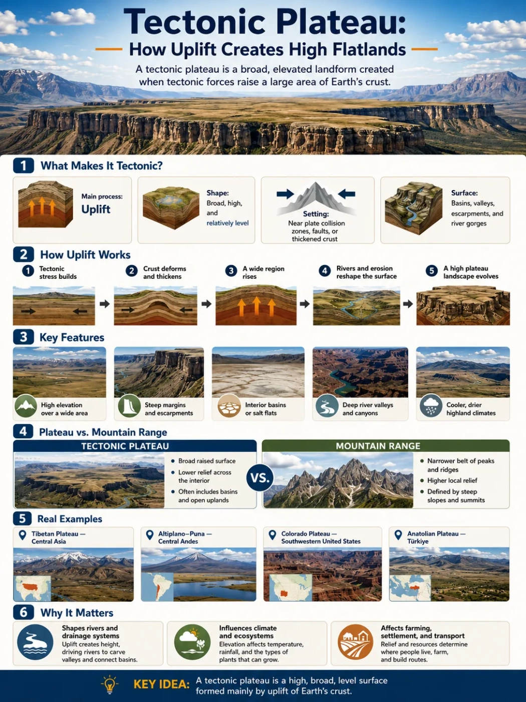
Landform Process
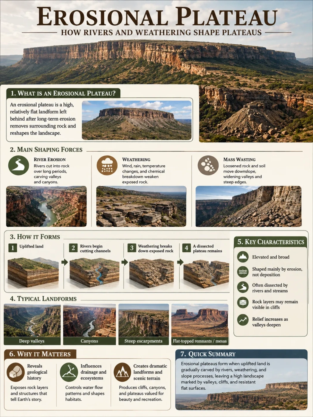
An erosional plateau is a raised land surface shaped less by fresh lava or active mountain building and more by the slow cutting power of rivers, rain, frost, wind and weathering. Its story is written in valleys, escarpments, mesas, canyons and uneven high ground that once looked flatter than it does today.
An erosional plateau is not usually a plateau created by erosion alone. In most cases, the land first becomes high because of uplift, volcanic construction, old sedimentary layers or regional crustal movement. Then erosion starts to carve it. Rivers cut channels into the surface. Weathering breaks rock apart. Slopes retreat. Valleys widen. Over long periods, the plateau keeps its raised position, but its surface becomes broken and uneven.
This is why erosional plateaus are often connected with the term dissected plateau. A dissected plateau still has a broad highland identity, but it may not look like a simple flat table from the ground. Instead, it may appear as ridges, canyon rims, steep valleys and isolated flat-topped remnants.
| Feature | What It Means | Why It Matters |
|---|---|---|
| Erosional Plateau | A raised land surface strongly shaped by erosion after uplift or formation. | Shows how rivers and weathering can reshape a highland without removing its plateau identity. |
| Dissected Surface | A plateau surface cut by valleys, gorges, ravines or canyons. | Helps explain why some plateaus look mountainous on the ground. |
| River Incision | Downward cutting by a river into bedrock or older sediment. | Creates deep valleys and canyon systems within plateau regions. |
| Escarpment | A steep slope or cliff marking the edge of a plateau or rock layer. | Often forms as softer rocks erode faster than harder layers. |
| Residual Landform | A remaining high area such as a mesa, butte or ridge after surrounding land erodes. | Shows how a former broad surface can be reduced into smaller flat-topped forms. |
Geography Note
An erosional plateau is best understood as a landscape stage, not always a separate origin type. The plateau may begin through uplift, lava flows or sedimentary layering, but erosion later becomes the process that gives it its visible form.
What Makes a Plateau Erosional?
A plateau becomes erosional when its shape is controlled mainly by the removal of rock and soil. Water, gravity, frost, heat, vegetation and wind all take part, but rivers usually leave the clearest marks.
The basic pattern is simple: a raised surface gives streams enough slope to flow with energy. Those streams cut downward and sideways. As valleys deepen, the old plateau surface survives only on ridge tops, canyon rims or broad upland blocks.
This creates a mixed landscape. One part may still look like a tableland. Another part may look like hills. A third part may show deep canyons. The plateau identity comes from the shared high elevation and the old surface level, not from perfect flatness.
Surface Clue
High Ridges at Similar Levels
Many erosional plateaus keep ridge tops at roughly similar elevations. This hints that the land may once have had a broader, smoother surface.
River Clue
Deep Valleys and Canyons
Rivers often cut sharply into uplifted plateau rocks, especially where bedrock is exposed and stream gradients are strong.
Rock Clue
Hard and Soft Layers
Resistant rock layers may form cliffs, benches and mesa tops, while softer layers erode into slopes or valleys.
Map Clue
Broken Drainage Pattern
Dense stream networks, branching valleys and canyon systems often show that erosion has strongly dissected the plateau surface.
How Rivers Shape Erosional Plateaus
Rivers are the main cutting tools in many erosional plateau landscapes. A river does not need to be large to begin this work. Small streams, seasonal washes and tributaries can cut into slopes, carry sediment and extend drainage networks across the plateau surface.
Over time, these channels link together. The land between them becomes ridges, spurs or flat-topped remnants. Where a river has enough energy, it may cut a canyon. Where the river loses energy, it may drop sediment in valleys, floodplains or alluvial fans near plateau margins.
Raised Surface Develops
A plateau begins as a high land surface through uplift, lava buildup, sedimentary layering or a mix of processes.
Streams Find Slope
Rainfall, snowmelt or springs feed streams that move from higher areas toward lower basins.
Channels Cut Down
Rivers and streams incise into rock, forming valleys, ravines or canyons where flow is strong enough.
Weathering Widens the Pattern
Freeze-thaw action, heat stress, chemical weathering and gravity loosen rock from slopes and cliffs.
Remnants Mark the Old Plateau
Mesas, ridges, benches and canyon rims may preserve pieces of the former high surface.
Vertical Cutting and Sideways Erosion
River erosion works in two main directions. Vertical incision cuts downward into the plateau. This deepens valleys and can expose older rock layers. Lateral erosion works sideways, widening valleys and undercutting slopes.
In young or recently uplifted plateau landscapes, vertical cutting may dominate. In older landscapes, valley widening and slope retreat may become more visible. Both processes can happen together, especially after floods or changes in base level.
Why Base Level Matters
Base level is the lower limit toward which a river erodes. It may be sea level, a lake, a larger river or a local basin. If base level drops, rivers can gain more cutting power. If the plateau rises, rivers may also cut deeper because the slope between highland and lowland becomes steeper.
This is one reason deep canyons often form in uplifted plateau regions. The river is not simply flowing across a flat surface. It is responding to height difference, rock strength, water volume and sediment load.
Field Note
A deeply cut plateau does not stop being a plateau just because it has valleys. If the highest ridges, rims or benches still align with a broad elevated surface, the landform may still be read as a dissected or erosional plateau.
Weathering: The Quiet Partner of River Erosion
Weathering breaks rock before erosion moves it. On a plateau, this can happen in several ways. Water enters cracks. Roots widen joints. Frost expands in rock pores. Heat and cooling cause stress in exposed surfaces. Chemical reactions weaken minerals, especially where moisture is common.
Once rock is loosened, gravity and water remove it. Pieces fall from cliffs, slide down slopes or wash into channels. Rivers then carry this material away. The process may look slow, but over long periods it can reshape an entire plateau margin.
| Weathering Process | Where It Is Common | Effect on a Plateau |
|---|---|---|
| Freeze-Thaw Weathering | Cold uplands, high elevations and seasonal climates | Breaks rock along cracks and helps form talus below cliffs. |
| Chemical Weathering | Humid plateaus, limestone regions and weathered volcanic rocks | Dissolves or weakens minerals, widening joints and drainage paths. |
| Thermal Stress | Dry plateaus with strong day-night temperature changes | Can help loosen exposed rock surfaces over time. |
| Biological Weathering | Vegetated slopes, cracks and soil-covered uplands | Roots, burrowing animals and organic acids help open rock fractures. |
| Mass Wasting | Steep canyon walls, escarpments and valley sides | Moves weathered material downslope, feeding rivers with sediment. |
Common Landforms Found on Erosional Plateaus
Erosional plateaus rarely have one simple shape. They are usually landform mosaics. A map may show a plateau name across a wide region, while the ground itself includes cliffs, ridges, valleys, mesas and basins.
Flat-Topped Remnant
Mesa
A broad, flat-topped high area left behind as erosion removes surrounding rock. Mesas often show resistant caprock.
Smaller Remnant
Butte
A smaller isolated hill or tower, often wider at the top than a spire but narrower than a mesa.
River-Cut Feature
Canyon
A deep, steep-sided valley carved mainly by river incision and slope erosion.
Plateau Edge
Escarpment
A steep slope or cliff that marks a sharp break between a plateau surface and lower land.
Erosion Surface
Bench
A step-like surface formed where rock layers erode at different rates.
Drainage Form
Basin
A lower area that collects water and sediment from surrounding plateau slopes or river systems.
Erosional Plateau vs Dissected Plateau
The two terms are closely related, but they are not always used in exactly the same way. Erosional plateau focuses on the process: erosion shapes the land. Dissected plateau focuses on the visible result: the plateau has been cut into valleys, ridges and canyons.
Erosional Plateau
- Describes a plateau shaped strongly by erosion.
- Highlights rivers, weathering, slope retreat and sediment removal.
- May include broad upland surfaces, canyon systems and worn plateau margins.
- Useful when explaining how a plateau changes over time.
Dissected Plateau
- Describes a plateau already cut into by valleys and drainage networks.
- Highlights the broken, rugged appearance of the land surface.
- May look like hills or mountains from the ground.
- Useful when reading maps and landscape patterns.
Common Mix-Up
A dissected plateau can look mountainous, but it is not the same as a mountain belt formed mainly by folding, faulting and strong crustal compression. The key clue is often the survival of a broad high surface or similar ridge-top elevation across the region.
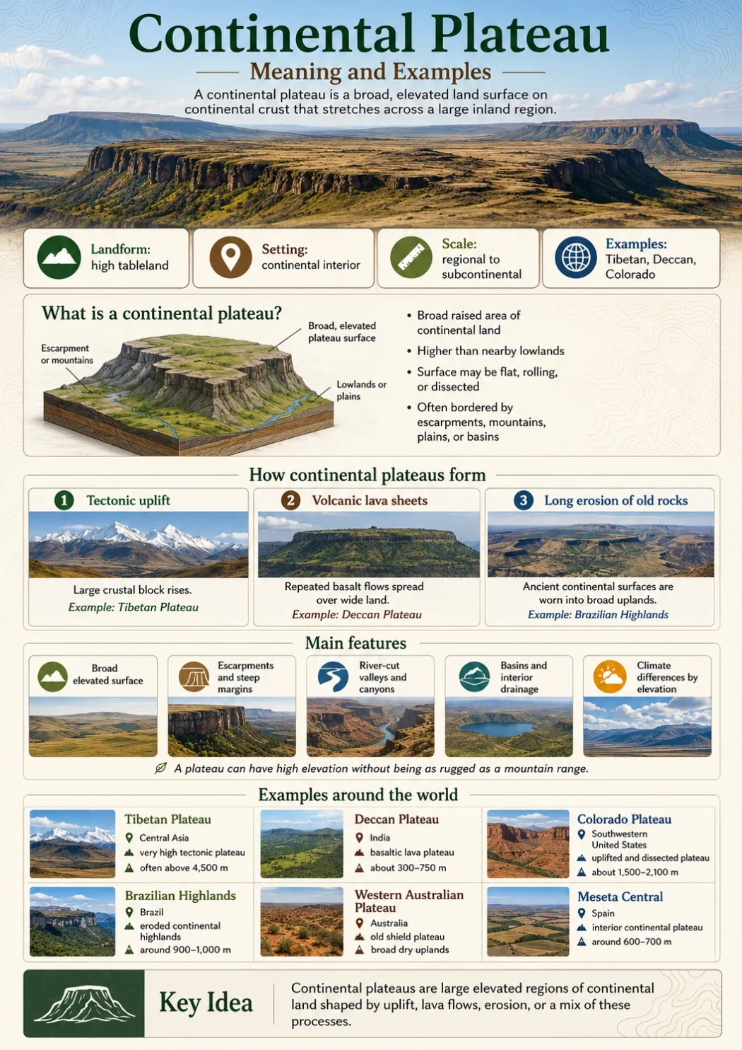
How Erosional Plateaus Differ from Other Plateau Types
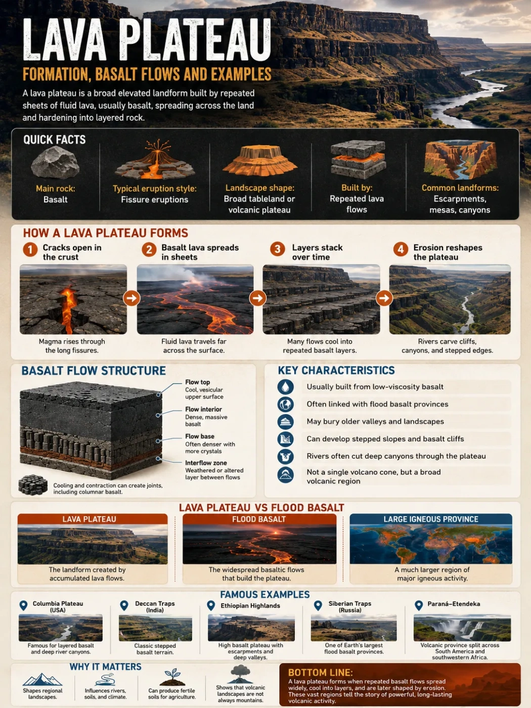
Many plateau categories overlap. A volcanic plateau can later become erosional. A tectonic plateau can become dissected by rivers. A sedimentary plateau can develop mesas and canyons as weathering removes weaker layers.
So the safest way to classify a plateau is to ask two questions: How did the land become high? and what process controls its present shape?
| Plateau Type | Main Origin or Shape Driver | Typical Landscape Clues | How It Connects to Erosion |
|---|---|---|---|
| Erosional Plateau | Shaped mainly by river erosion, weathering and slope retreat after formation. | Valleys, canyons, escarpments, mesas, ridges and uneven high ground. | Erosion is the main visible sculptor. |
| Dissected Plateau | A plateau cut by streams into a rugged surface. | Branching valleys, sharp relief and ridge tops at similar levels. | Often a strong example of erosional shaping. |
| Volcanic Plateau | Built by repeated lava flows or volcanic material. | Layered basalt, broad lava plains, cliffs and step-like edges. | May later be deeply eroded by rivers. |
| Tectonic Plateau | Raised by crustal uplift, compression or broad regional movement. | High elevation, large scale, nearby mountain systems or basins. | Rivers may cut into it after uplift. |
| Intermontane Plateau | Lies between mountain ranges. | High basins, internal drainage, dry valleys or broad uplands. | Erosion depends on climate, drainage and rock type. |
Stages in the Life of an Erosional Plateau
Erosional plateaus do not form in one short event. They develop through repeated adjustments between uplift, climate, rock strength and drainage. The stages below are simplified, but they help explain the pattern seen on many plateau maps.
High Surface or Layered Land Develops
The region becomes a plateau through uplift, lava accumulation, sedimentary layering or regional crustal movement.
Drainage Network Expands
Streams begin to organize across the surface. Water follows weak zones, slopes and existing low points.
Valleys Cut Into the Plateau
Rivers deepen channels, tributaries spread, and the plateau becomes dissected.
Slopes Retreat and Remnants Form
Weathering, rockfall and stream erosion create mesas, buttes, benches and isolated high surfaces.
Relief Becomes More Complex
The plateau may look rugged, but matching high points and broad regional elevation still reveal its plateau structure.
Measurement Note
Elevation, area and exact boundaries can vary for erosional plateau regions because the plateau may grade into mountains, basins, plains or escarpments. In many cases, maps define the region more clearly than a single elevation number.
Examples of Erosional and Dissected Plateau Landscapes
Real plateau landscapes are rarely one-process systems. The examples below are useful because erosion plays a clear role in their present appearance. Some began through uplift or older geologic construction, then rivers and weathering carved them into more complex landforms.
| Plateau or Region | Location | Erosional Features | Why It Is Useful for Understanding the Type |
|---|---|---|---|
| Colorado Plateau | Southwestern United States | Canyons, mesas, buttes, cliffs and deeply exposed sedimentary layers. | Shows how river incision can cut dramatic relief into a broad high plateau region. |
| Cumberland Plateau | Eastern United States | Dissected valleys, sandstone cliffs, gorges and ridge systems. | Often described as a dissected plateau because streams have cut strongly into the upland surface. |
| Ozark Plateau | Central United States | Uplands, valleys, springs, karst areas and eroded sedimentary rocks. | Shows how erosion and drainage can shape a broad interior highland. |
| Deccan Plateau Margins | India | Escarpments, river valleys, lava-layer steps and dissected edges. | Demonstrates how a volcanic plateau can later be modified by long-term erosion. |
| Yunnan-Guizhou Plateau | Southwest China | Deep valleys, karst terrain, river gorges and uneven uplands. | Shows how water erosion and rock type can create a highly varied plateau surface. |
Map Note
On a physical map, an erosional plateau may not appear as a smooth block. Look for a raised region with repeated valley cuts, canyon lines, escarpments and high remnants that share a similar regional level.
Climate and Rock Type Control the Shape
Climate changes how erosion works on a plateau. In dry regions, rivers may be seasonal but powerful during storms. Sparse vegetation can leave slopes exposed, so flash floods may move sediment quickly. This can help form canyons, washes, cliffs and isolated flat-topped remnants.
In humid regions, more regular rainfall supports dense drainage networks. Chemical weathering can be stronger, especially in limestone or other soluble rocks. Valleys may become wider, slopes may become rounded, and vegetation can slow some erosion while also helping weathering through roots and organic acids.
Cold plateau climates add another process: freeze-thaw weathering. Water enters cracks, freezes, expands and helps break rock apart. This can feed talus slopes and rockfall below cliffs.
Hard Rock, Soft Rock and Layered Plateaus
Layered rocks are common in many plateau regions. When a hard layer sits above softer rock, erosion often creates cliffs and benches. The hard layer protects the top surface for a time. The softer rock beneath erodes faster, undercutting the edge. Eventually blocks collapse, and the plateau margin retreats.
This is why many erosional plateaus have step-like profiles. The shape is not random. It reflects differences in rock strength, bedding, joints and drainage.
Rivers, Basins and Plateau Margins
Plateaus affect river systems because they guide water from high surfaces toward lower basins. Some rivers rise on plateaus. Others cut across plateau regions after beginning in nearby mountains. Tributaries may drain inward to closed basins or outward toward seas and larger river systems.
At plateau margins, erosion can be especially visible. Streams may cut through escarpments, form waterfalls, create narrow gorges or carry sediment into lowland basins. These edges often show the strongest contrast between plateau surface and surrounding land.
| River or Basin Feature | How It Works on a Plateau | Visible Result |
|---|---|---|
| Headwater Streams | Small channels begin on upland surfaces and join larger drainage systems. | Branching valleys and narrow cuts near the plateau interior. |
| Main River Incision | A larger river cuts downward through plateau rock over long periods. | Deep canyon, gorge or steep-sided valley. |
| Tributary Dissection | Side streams cut into slopes and connect to the main valley. | Rugged relief and dense drainage pattern. |
| Escarpment Drainage | Streams cross a steep plateau edge and drop toward lower ground. | Waterfalls, steep valleys and eroding plateau margins. |
| Sediment Delivery | Weathered material moves from slopes into channels and basins. | Alluvial fans, valley fill, floodplains or sediment layers downstream. |
Why Erosional Plateaus Matter in Geography
Erosional plateaus help explain how highlands change after they form. They connect geology with drainage, climate, soil, settlement and map reading. A plateau is not only a high flat area. It can be a long-lived landscape system where water slowly reorganizes the surface.
These plateaus also matter because they influence human use of land. Flat remnants may support roads, towns, farms or grazing. Valleys may carry rivers, railways and settlements. Escarpments can limit movement or create strong local elevation changes. Canyon landscapes may shape tourism, water storage, conservation and route planning.
So the geography is practical. Erosion affects where people can build, farm, travel, collect water and manage slope risk.
Landform Note
Erosional plateaus often contain both usable high surfaces and difficult terrain. The same plateau may include broad upland roads, steep valley walls, narrow gorges and isolated communities separated by relief.
How to Recognize an Erosional Plateau on a Map
A map cannot show every rock layer, but it can reveal the main pattern. Start by looking for an elevated region. Then check whether valleys cut into it from several directions. If the highest surfaces remain broad or align at similar levels, the land may be a dissected plateau rather than a simple hill region.
| Map Sign | What to Look For | Possible Meaning |
|---|---|---|
| Similar Ridge Heights | Ridge tops or mesa tops sitting at roughly related elevations. | Remnants of an older plateau surface may remain. |
| Dense Drainage Lines | Many streams cutting into the plateau from different directions. | The surface has been strongly dissected by erosion. |
| Sharp Contour Spacing | Contours close together along valley sides or escarpments. | Steep slopes, canyon walls or plateau edges are present. |
| Flat-Topped Remnants | Mesas, benches or isolated high areas with steep sides. | Hard caprock may be protecting old surface pieces. |
| River Cutting Across High Ground | A river crossing or slicing into a raised region. | Incision may have shaped the plateau landscape. |
Erosional Plateau, Mesa, Butte and Plain: Clear Differences
Several landforms can appear together in eroded plateau regions. The difference is mainly scale, elevation and relationship to the older surface.
| Landform | Basic Shape | Scale | Connection to Erosion |
|---|---|---|---|
| Erosional Plateau | Large raised surface shaped by erosion. | Regional | Rivers and weathering carve the plateau into valleys, cliffs and remnants. |
| Mesa | Flat-topped high area with steep sides. | Smaller than a plateau | Often a remnant of a former plateau or tableland surface. |
| Butte | Isolated steep-sided hill, often with a small flat top. | Smaller than a mesa | Usually forms after more erosion removes surrounding rock. |
| Plain | Broad low or gently rolling land. | Regional | May be shaped by deposition, erosion or both, but is not defined by being a raised tableland. |
| Mountain Belt | High, rugged terrain with strong relief. | Regional | Often formed mainly by tectonic compression, folding, faulting or volcanic activity. |
Useful Terms for Reading Erosional Plateaus
Plateau
A raised landform with a relatively broad upper surface. It may be smooth, rugged, dissected or partly broken by valleys.
Tableland
A broad, elevated area that appears table-like. The term is often used for flatter plateau surfaces.
Dissection
The cutting of a land surface by streams and valleys. A highly dissected plateau may look rough or mountainous.
River Incision
Downward erosion by a river into bedrock or older sediment. It is one of the main processes behind canyons.
Escarpment
A steep slope or cliff marking a sharp change in elevation, often along a plateau edge or resistant rock layer.
Caprock
A harder rock layer that protects softer material below it, helping mesas and cliffs survive longer.
Drainage Basin
The area of land drained by a river and its tributaries. Plateau basins help control where erosion and sediment movement occur.
Slope Retreat
The backward movement of cliffs or steep slopes as weathering and erosion remove material from their faces and bases.
FAQ
What is an erosional plateau?
An erosional plateau is a raised land surface whose present shape has been strongly carved by erosion. Rivers, weathering, slope movement and sediment removal cut into the plateau and create valleys, cliffs, canyons, mesas or ridges.
Is an erosional plateau the same as a dissected plateau?
They are closely related. An erosional plateau describes the process of shaping by erosion. A dissected plateau describes the result: a plateau that has been cut into by valleys and drainage networks.
Can rivers form a plateau by themselves?
Rivers usually do not create the original high elevation of a plateau by themselves. The land often becomes high through uplift, volcanic activity or older geologic structure. Rivers then carve and reshape that high surface.
Why do some plateaus have deep canyons?
Deep canyons form when rivers cut downward into plateau rock over long periods. Strong river flow, uplift, steep gradients, resistant bedrock and changes in base level can all help deepen valleys.
How can a plateau be flat if erosion cuts it apart?
A plateau does not need to be perfectly flat everywhere. In an erosional or dissected plateau, parts of the old high surface may survive on ridge tops, benches or mesas, while rivers cut deep valleys between them.
What landforms are common on erosional plateaus?
Common landforms include canyons, gorges, mesas, buttes, escarpments, benches, ridges, ravines and river valleys. These features show how erosion breaks a broad highland into smaller landform pieces.
Are erosional plateaus found only in dry regions?
No. Dry regions often show sharp cliffs, mesas and canyons clearly because vegetation is sparse, but erosional plateaus can also form in humid or cold climates. The exact shape depends on water, rock type, slope, vegetation and climate.
What is the easiest way to identify an erosional plateau on a map?
Look for a raised region with valleys cutting into it, steep contour lines along canyon walls or escarpments, and high remnants that sit at similar levels. These clues suggest that a broader plateau surface has been dissected by erosion.