Plateau Type
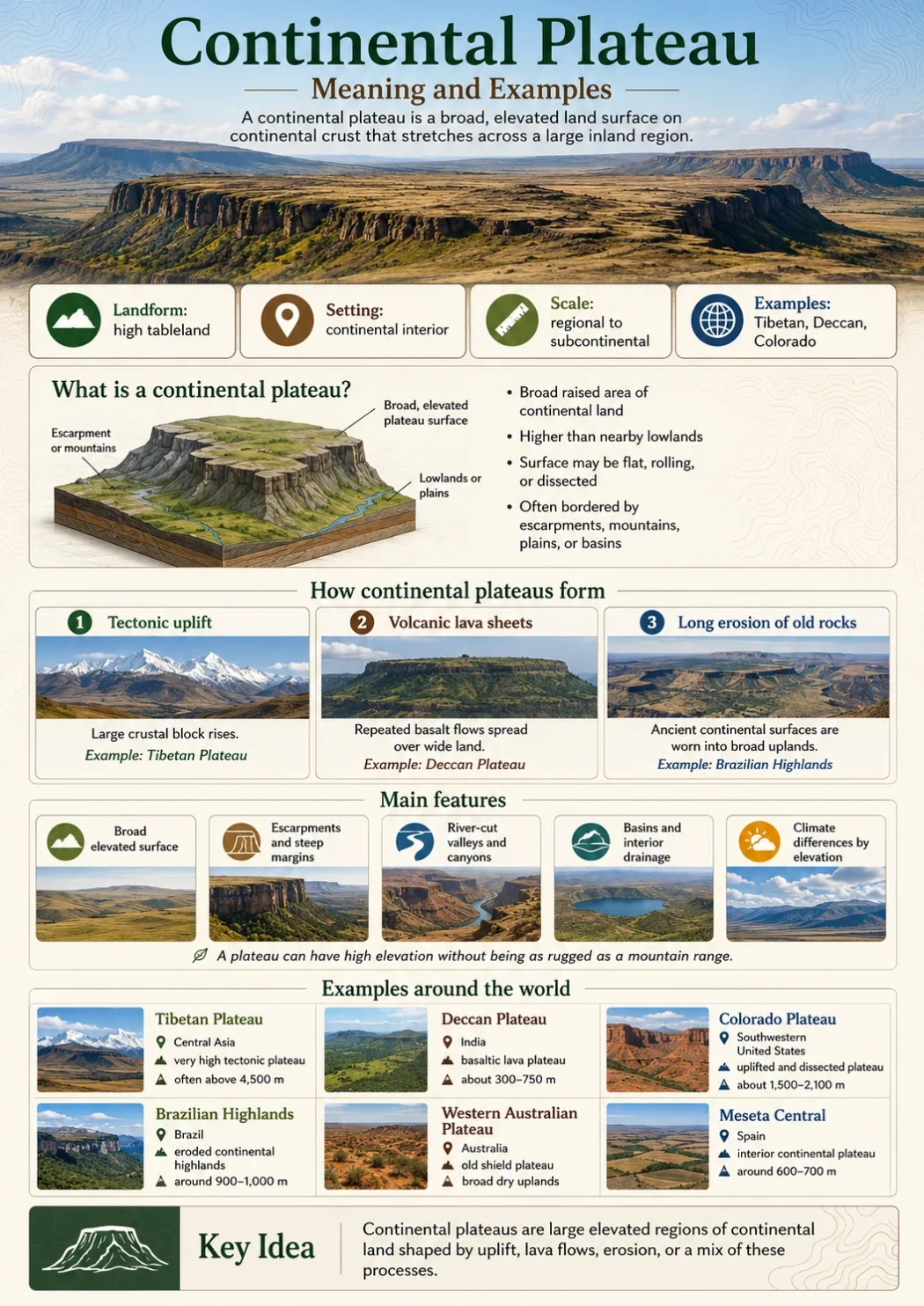
A continental plateau is a broad, raised land surface that sits on continental crust and spreads across a large inland region, often with steep edges, old rocks, river-cut valleys, dry basins, or lava-covered plains.
A continental plateau is one of the broadest forms of elevated land on Earth. It is not simply a flat hill, a mesa, or a mountain plain. It is a large plateau region that forms part of a continent’s physical structure.
Some continental plateaus rise because the crust has been lifted. Others form when huge sheets of lava spread across older land and harden into a wide volcanic tableland. Many are later cut by rivers, edged by escarpments, or broken into smaller uplands by erosion.
Landform Note
The word continental does not mean the plateau covers an entire continent. It means the plateau is part of continental land, usually broad enough to affect drainage, settlement, travel routes, climate, or regional landscapes.
| Feature | Explanation |
|---|---|
| Simple meaning | A wide, elevated land surface on continental crust, often with a fairly level or gently rolling upper surface. |
| Main setting | Interior parts of continents, highland shields, uplifted crustal blocks, or large lava-covered areas. |
| Typical edges | Escarpments, mountain fronts, deeply cut valleys, or gradual slopes toward plains and basins. |
| Common formation | Tectonic uplift, long erosion of old continental rocks, broad lava flows, or a mix of these processes. |
| Examples | Tibetan Plateau, Deccan Plateau, Colorado Plateau, Brazilian Highlands, Western Australian Plateau, and Meseta Central. |
What Is a Continental Plateau?
A continental plateau is a large elevated landform that forms across part of a continent rather than along a small local ridge or isolated hill. It may look like a high plain on a small-scale map, but the land often includes valleys, low mountains, basins, cliffs, lava fields, and river systems.
The top surface is usually higher than nearby lowlands. It may be flat, gently rolling, tilted, or broken by erosion. The edges can be sharp where an escarpment drops toward a plain, sea, river basin, or coastal lowland.
Continental plateaus are often old. Many sit on ancient continental rocks that have been lifted, worn down, buried by lava, or carved by rivers over long geologic time.
Short Definition
A continental plateau is a broad, raised area of continental land that stands above nearby regions and extends across a large inland area.
More Useful Geography Definition
In geography, a continental plateau is best understood as a large highland surface that helps shape regional drainage, climate, settlement patterns, and the layout of plains, mountains, and river basins around it.
Simple rule: If the landform is broad, elevated, part of a continental region, and much larger than a mesa or butte, it may be described as a continental plateau.
How Continental Plateaus Form
Continental plateaus do not all form in the same way. A plateau may begin as uplifted crust, as a lava-covered surface, or as an old landmass shaped by erosion. Some plateaus show more than one process at the same time.
Tectonic Uplift
Many continental plateaus form when a large part of Earth’s crust rises. This uplift may happen near plate boundaries, within old continental blocks, or along the edge of mountain systems.
The Tibetan Plateau is the clearest high-elevation example. It is linked to the collision between the Indian Plate and the Eurasian Plate. The result is a vast upland region bordered by major mountain ranges, including the Himalaya to the south.
The Colorado Plateau in the southwestern United States also shows uplift, but in a different way. Much of the region remained relatively flat compared with nearby folded and faulted mountain belts, while rivers later cut deep canyons through its raised rock layers.
Volcanic Lava Sheets
Some continental plateaus form when repeated lava flows spread across wide areas. The lava fills older valleys, covers uneven land, and builds a broad basalt surface.
The Deccan Plateau of India includes large areas of basalt from ancient lava flows. The Columbia Plateau in the northwestern United States is another well-known lava plateau, built from thick basalt flows and later shaped by the Columbia River system.
Long Erosion of Old Continental Rocks
Other continental plateaus are shaped by long erosion across ancient rocks. Over time, softer material wears down, harder rock remains, and broad upland surfaces may be left behind.
The Brazilian Highlands and the Western Australian Plateau include old continental surfaces that have been worn, lifted, and divided into uplands, basins, escarpments, and tablelands.
Geography Note
A plateau can be high without being mountainous. Elevation describes height above sea level. Relief describes how much the land rises and falls locally. A plateau may have high elevation but moderate local relief across its upper surface.
Main Features of Continental Plateaus
Continental plateaus are easier to read on a map when their shape, edges, rocks, and drainage are viewed together.
Broad Elevated Surface
The surface of a continental plateau covers a large area. It may cross provinces, states, regions, or even several countries. The land may look fairly level from far away, even if local valleys and hills break the surface.
Escarpments and Steep Margins
Many continental plateaus have steep margins. These margins form where the plateau drops toward a plain, coastal belt, desert basin, or river lowland.
An escarpment is a long steep slope or cliff-like edge. On maps, escarpments often appear where contour lines sit close together along one side of a highland.
River-Cut Valleys
Rivers can cut deeply into a raised plateau. Over time, this creates canyons, gorges, ravines, and dissected uplands.
The Colorado Plateau is a strong example. Its rock layers are high and broad, but rivers such as the Colorado River and its tributaries have carved deep valleys into the plateau surface.
Basins and Interior Drainage
Some continental plateaus include interior basins where water drains inward instead of reaching the sea. In dry regions, these basins may hold salt flats, seasonal lakes, or dry stream channels.
This matters because a plateau is not only a high surface. It can also control where rivers start, how they flow, and whether water moves toward an ocean, a desert basin, or a large inland lake.
Climate Differences by Elevation
Elevation changes climate. Higher plateau surfaces are often cooler than nearby lowlands. Dry plateaus may have strong temperature swings between day and night. Wet plateau margins may feed rivers and forests, while rain-shadow interiors can be semi-arid or arid.
Elevation Note
Continental plateaus do not share one fixed elevation. Some sit a few hundred meters above sea level, while very high plateaus such as the Tibetan Plateau rise above 4,000 meters across wide areas.
Continental Plateau Examples Around the World
The examples below show how varied continental plateaus can be. Some are high and cold. Some are dry and old. Some are volcanic. Others are wide eroded highlands with rivers, escarpments, farms, cities, and mineral-rich rocks.
| Plateau or Highland Region | Main Location | Approximate Elevation | Main Landform Type | Known For |
|---|---|---|---|---|
| Tibetan Plateau | Central Asia, mainly western China, with margins linked to South and Central Asia | Often described as averaging above 4,500 m | High tectonic plateau | Very high elevation, major Asian river headwaters, Himalayan margin |
| Deccan Plateau | India, south of the Narmada River | Commonly around 300–750 m, with higher and lower local areas | Ancient shield and basaltic lava plateau | Black soils, east-flowing rivers, Western and Eastern Ghats |
| Colorado Plateau | Southwestern United States | Plateau tops often around 1,500–2,100 m | Uplifted and dissected plateau | Canyons, mesas, buttes, exposed rock layers |
| Brazilian Highlands | Central and southeastern Brazil | Often described near 900–1,000 m on average | Eroded continental highlands and tablelands | Major river sources, uplands, escarpments, mineral regions |
| Western Australian Plateau | Western and central Australia | Mostly moderate elevations, with broad dry uplands | Old continental shield plateau | Ancient rocks, deserts, low-relief upland surfaces |
| Meseta Central | Interior Spain | Often around 600–700 m | Interior continental plateau | High interior plains divided by mountain ranges and river basins |
| Arabian Plateau | Arabian Peninsula | Varies widely by region | Dry continental plateau and upland surface | Desert basins, escarpments, wadis, broad inland surfaces |
Tibetan Plateau
The Tibetan Plateau is the highest large plateau on Earth. It sits in Central Asia and is bordered by some of the planet’s highest mountain ranges.
Its height affects climate, glaciers, wind patterns, and river systems. Several major Asian rivers rise on or near the plateau region, including the Indus, Brahmaputra, Mekong, Yangtze, and Yellow River systems.
This plateau is not a smooth flat slab. It includes basins, ranges, lakes, river valleys, cold steppe, alpine land, and high desert surfaces. Its size and height make it a clear example of a continental plateau shaped by tectonic uplift.
Deccan Plateau
The Deccan Plateau occupies much of peninsular India. It lies south of the Narmada River and is bordered in broad terms by the Western Ghats and Eastern Ghats.
Large parts of the Deccan are linked with ancient basalt lava flows. The plateau slopes generally eastward, so many major rivers, including the Godavari, Krishna, and Kaveri systems, flow toward the Bay of Bengal.
The Deccan shows why continental plateaus matter for human life. Its soils, rainfall patterns, river valleys, and upland cities all connect to the shape of the plateau.
Colorado Plateau
The Colorado Plateau covers parts of Arizona, Utah, Colorado, and New Mexico. It is known for high plateau surfaces, mesas, buttes, cliffs, and deeply carved canyons.
Its rock layers stayed relatively level compared with nearby mountain belts, then rose and were cut by rivers. This combination makes the region one of the clearest places to see how uplift and erosion work together.
The Grand Canyon is part of this larger plateau story. The canyon is not the plateau itself; it is a river-cut feature within the raised plateau region.
Brazilian Highlands
The Brazilian Highlands form a large highland region across central and southeastern Brazil. The area includes low mountains, rolling uplands, tabular plateaus, river sources, and long escarpments.
This region helps shape major drainage systems in South America. Rivers linked to the highlands feed parts of the Paraná, São Francisco, Tocantins-Araguaia, and other basins.
The Brazilian Highlands are a useful example because they are not one simple flat surface. They show how an old continental region can include several plateau-like areas within a wider upland landscape.
Western Australian Plateau
The Western Australian Plateau is part of Australia’s old continental interior. It includes dry uplands, deserts, ancient rocks, and broad surfaces with low to moderate relief.
This type of plateau may not look dramatic on the ground. Its importance becomes clearer on a physical map, where the raised interior contrasts with coastal lowlands and basin areas.
Continental Plateau vs Other Plateau Types
Plateau terms often overlap. A single plateau may be continental, volcanic, dissected, and intermontane depending on how it is being described. The table below separates the ideas.
| Term | Main Meaning | How It Differs From a Continental Plateau | Example |
|---|---|---|---|
| Continental plateau | Broad plateau region on continental crust | Focuses on scale and setting within a continent | Deccan Plateau, Brazilian Highlands |
| Intermontane plateau | Plateau enclosed or bordered by mountains | Focuses on position between mountain ranges | Tibetan Plateau |
| Piedmont plateau | Plateau at the foot of mountains | Focuses on location between mountains and plains | Appalachian Piedmont |
| Lava plateau | Plateau built by broad lava flows | Focuses on volcanic origin | Columbia Plateau, Deccan lava regions |
| Dissected plateau | Plateau cut by rivers and erosion | Focuses on carved valleys and broken surface | Colorado Plateau |
| Mesa | Smaller flat-topped landform with steep sides | Much smaller than a regional plateau | Mesas in the American Southwest |
Common Mix-Up
A mesa can sit inside a plateau region, but it is not the same thing as a continental plateau. A mesa is a smaller flat-topped feature. A continental plateau is a much wider land region.
How to Recognize a Continental Plateau on a Map
A continental plateau is not always obvious from a political map. A physical map, elevation map, or relief map gives better clues.
Look for a Wide Area of Higher Elevation
The first clue is a broad zone of land that stands higher than nearby plains, basins, or coasts. On elevation maps, it may appear as a wide block of higher color rather than a narrow mountain chain.
Check the Edges
Plateau edges often show a change from highland to lowland. Closely spaced contour lines, long cliff-like margins, or named escarpments can mark the boundary.
Follow the Rivers
Rivers often start on plateaus or cut through them. If several rivers flow away from a highland surface, the plateau may act as a drainage divide.
In other cases, one major river cuts across the plateau and forms canyons or gorges. This is common where uplift gives rivers more energy to cut downward.
Compare It With Nearby Landforms
A mountain range is usually narrower and more rugged. A plain is lower and flatter. A basin is often lower than surrounding land. A continental plateau sits between these ideas: raised like a highland, broad like a plain, and often shaped by rivers like a dissected landscape.
Map Note
On a small map, a continental plateau may look like a plain because the surface is broad. Check elevation, drainage, and surrounding slopes before deciding what landform it is.
Why Continental Plateaus Matter in Geography
Continental plateaus shape more than scenery. They affect rivers, climate, soils, transport, farming, settlement, and regional identity.
They Shape River Basins
High plateau surfaces often act as water divides. Rain and snowmelt may flow in different directions from the same upland region. This can feed large river basins and create deep valleys along plateau margins.
They Influence Climate
Elevation usually brings cooler air. A high plateau can have colder conditions than nearby lowlands at the same latitude. Plateau edges can also affect rainfall by forcing moist air to rise.
Dry continental plateaus may have sparse vegetation, wide temperature swings, and seasonal streams. Wetter plateau margins may support forests, farms, or dense settlement.
They Preserve Rock Layers
Some plateaus expose long sequences of rock. Where rivers cut down into them, older layers can appear in canyon walls. This makes dissected plateaus useful for understanding geologic time and past environments.
They Guide Human Settlement
People often use plateau surfaces for farming, grazing, mining, roads, towns, and cities when water and soils allow it. In dry plateau interiors, settlement may cluster near rivers, springs, oases, or valley floors.
Plateaus can also create travel barriers. Escarpments, canyon systems, and steep margins may make routes more difficult than the relatively open surface suggests.
Continental Plateau and Climate Patterns
A plateau’s climate depends on elevation, latitude, distance from the ocean, wind direction, and nearby mountains. There is no single continental plateau climate.
High Cold Plateaus
Very high plateaus, such as the Tibetan Plateau, have cold conditions across large areas. Thin air, strong sunlight, frost, and alpine or steppe landscapes are common in many parts of such uplands.
Dry Interior Plateaus
Many continental plateaus lie far from moist ocean air. These areas may have deserts, semi-arid grasslands, seasonal streams, and salt basins. The Arabian Plateau and parts of Australia show this pattern.
Tropical and Subtropical Plateaus
Some plateaus lie in warmer climate zones but are cooler than nearby lowlands because of elevation. The Brazilian Highlands and parts of the Deccan Plateau show how elevation, monsoon patterns, and regional drainage can create varied landscapes.
Continental Plateau, Basin, Highland, and Tableland
Several landform words overlap with continental plateau. The differences are practical rather than always strict.
Plateau
A plateau is a raised landform with a broad upper surface. It may be small or very large.
Continental Plateau
A continental plateau is a large plateau region tied to a continent’s interior, crustal structure, or broad highland surface.
Highland
A highland is a general word for raised land. It may include plateaus, hills, low mountains, and upland basins.
Tableland
A tableland is a fairly flat elevated area. It often describes the surface shape of a plateau rather than the full geologic setting.
Basin
A basin is a low or inward-draining area. Some basins sit on plateaus, while others lie beside plateau margins.
Common Misconceptions About Continental Plateaus
A Continental Plateau Is Not Always Perfectly Flat
Most plateaus are not flat like a tabletop. They may include valleys, hills, ridges, lava fields, lakes, dunes, and eroded slopes.
A Continental Plateau Is Not Always Extremely High
The Tibetan Plateau is very high, but many continental plateaus are much lower. The main idea is broad elevation compared with surrounding land, not one fixed height.
A Continental Plateau Is Not the Same as a Continent
A continent is a major landmass. A continental plateau is one landform region within a continent.
A Lava Plateau Can Also Be Continental
These terms can describe different things. “Lava plateau” describes origin. “Continental plateau” describes setting and scale. The Deccan and Columbia plateau regions show how both ideas can overlap.
Careful wording: Some geography texts use continental plateau for broad inland plateau regions. Some geology dictionaries use related terms such as continental platform in a wider crustal sense. For landform study, the useful meaning is the broad raised plateau surface on continental land.
Mini FAQ
What is a continental plateau in simple words?
A continental plateau is a large raised area of land within a continent. It is usually broader than a mesa, higher than nearby plains, and shaped by uplift, lava flows, erosion, or old continental rocks.
What are the best examples of continental plateaus?
Common examples include the Tibetan Plateau, Deccan Plateau, Colorado Plateau, Brazilian Highlands, Western Australian Plateau, Meseta Central, and Arabian Plateau. Each one has a different elevation, climate, and geologic history.
Is the Tibetan Plateau a continental plateau?
Yes. The Tibetan Plateau is a major continental plateau and also an intermontane plateau because it lies among very high mountain systems. It is known for its great elevation and its role in Asian river systems.
How is a continental plateau different from a mountain?
A mountain usually has a sharper peak or rugged high relief. A continental plateau is broader and has a raised surface that may be flat, rolling, or cut by valleys. A plateau can include mountains, but the landform itself is wider than a single mountain.
Can a continental plateau be volcanic?
Yes. A continental plateau can form partly or mainly from lava flows. The Deccan Plateau and Columbia Plateau are often used as examples of large basaltic plateau regions on continental land.
Why do rivers cut deep valleys into plateaus?
When a plateau rises or when nearby base level drops, rivers gain energy to cut downward. Over time, they carve canyons, gorges, and valleys into the raised surface.
Is a mesa the same as a continental plateau?
No. A mesa is a smaller flat-topped landform with steep sides. A continental plateau is a broad regional landform. Mesas can occur inside plateau regions, especially where erosion has broken a larger plateau surface into smaller features.