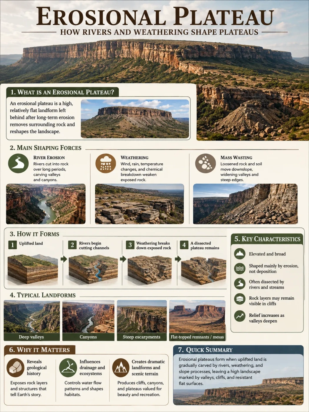
Landform Type
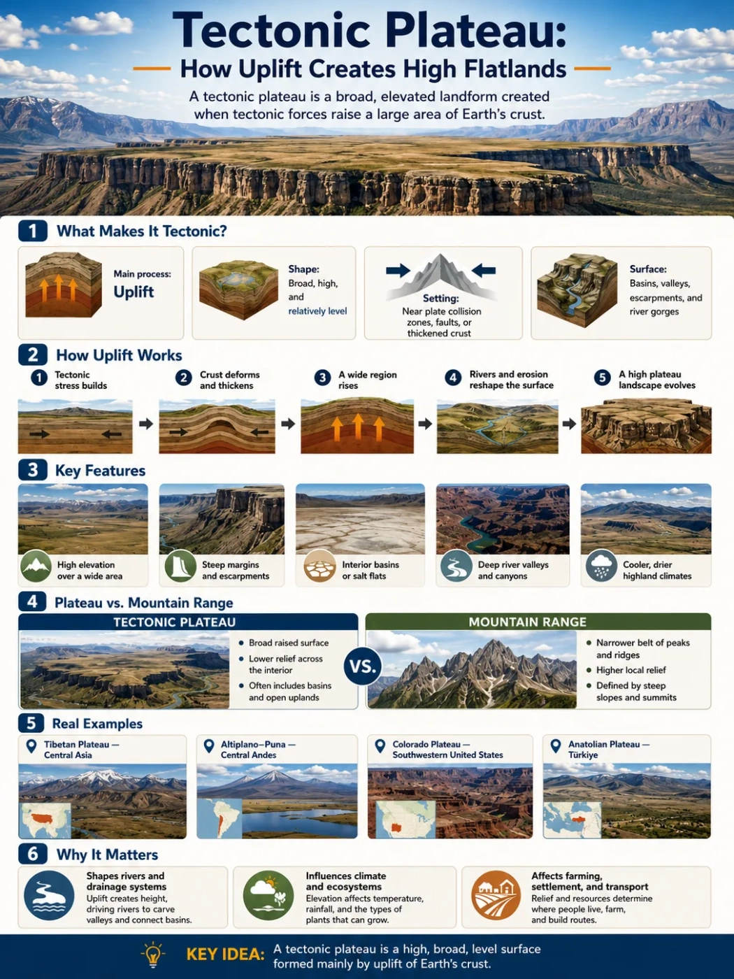
A tectonic plateau is a broad, raised highland formed when Earth movements lift large areas of crust while leaving much of the surface relatively open, wide, and plateau-like.
A tectonic plateau is not simply a flat place at high elevation. It is a raised landform shaped by forces inside the Earth: crustal shortening, fault movement, broad uplift, mantle heating, or long plate collision. These forces push a large region upward, sometimes over millions of years, while erosion, rivers, basins, and climate keep reshaping the surface.
The result can be surprising on a map. A tectonic plateau may sit thousands of meters above sea level, yet still look more open than a mountain range. It may contain valleys, lakes, river gorges, dry basins, towns, grasslands, salt flats, and mountain rims. The flatness is relative, not perfect.
| Feature | What It Means | Why It Matters |
|---|---|---|
| Main Process | Uplift caused by tectonic forces | Explains why the land sits high above nearby lowlands |
| Surface Shape | Broad, raised, and often uneven rather than perfectly flat | Helps separate plateaus from plains, mesas, and mountain chains |
| Common Setting | Near converging plates, folded belts, faults, or thickened crust | Links the plateau to regional geology and nearby mountains |
| Typical Relief | Low to moderate relief across the top, steep edges in places | Shows why plateaus can have escarpments, canyons, and basins |
| Examples | Tibetan Plateau, Altiplano-Puna region, parts of the Colorado Plateau | Shows that tectonic uplift can create very different plateau landscapes |
What Is a Tectonic Plateau?
A tectonic plateau is a high, broad area of land raised by movements of Earth’s crust. The land may rise because plates collide, the crust thickens, faults lift blocks upward, or heat below the lithosphere causes a wide area to swell.
The word plateau points to the landform shape: raised ground with a relatively level or gently rolling upper surface. The word tectonic points to the process: movement and deformation of Earth’s crust.
Landform Note
A tectonic plateau does not need to be as smooth as a table. Many have river valleys, fault scarps, interior basins, lake floors, volcanic fields, and rugged margins. The main idea is a broad raised surface, not perfect flatness.
This is why some tectonic plateaus can look like high plains from a distance, but like broken hill country when viewed closely. Scale matters. A plateau may appear flat on a continental map while containing steep local terrain on the ground.
How Uplift Creates High Flatlands
Uplift means that a land area rises relative to sea level or nearby terrain. In tectonic plateaus, that rise usually affects a wide region, not just a narrow ridge. The uplift can happen slowly, but the final landform may cover a large part of a country or even cross several borders.
The process usually follows a few connected steps:
- Stress builds in the crust as plates move, collide, pull apart, or slide past one another.
- Rock layers deform through folding, faulting, thickening, or broad bending.
- A wide region rises as the crust becomes thicker, warmer, lighter, or structurally lifted.
- Rivers and erosion cut into the surface, leaving valleys, canyons, escarpments, and basins.
- The plateau keeps evolving as uplift, weathering, sediment movement, and climate act together.
Uplift alone does not make a plateau. A narrow uplifted ridge is usually a mountain range. A small isolated flat-topped remnant may be a mesa or butte. A tectonic plateau needs width, elevation, and a surface that stays more open than a mountain chain.
Main Ways Tectonic Plateaus Form
Tectonic plateaus do not all form the same way. Some rise beside great mountain belts. Others form where the crust warms and expands. Some are lifted along faults, then carved by rivers. A few combine tectonic uplift with volcanism or long erosion.
| Formation Path | How It Works | Typical Landscape Result | Example Context |
|---|---|---|---|
| Crustal Shortening | Continental collision squeezes and thickens the crust. | Very high plateau with mountain rims, interior basins, and cold highland climates. | Tibetan Plateau and parts of the Andean highlands |
| Fault-Block Uplift | Faults lift blocks of crust above nearby areas. | Raised surfaces with steep scarps, tilted blocks, and nearby basins. | Uplifted plateau margins in active tectonic regions |
| Thermal Uplift | Heating below the lithosphere makes a broad region rise. | Large elevated surfaces that may later be cut by rivers and erosion. | Some continental plateau settings |
| Regional Doming | A wide crustal area arches upward over time. | Highland surfaces with outward-flowing drainage and eroded edges. | Broad interior uplands |
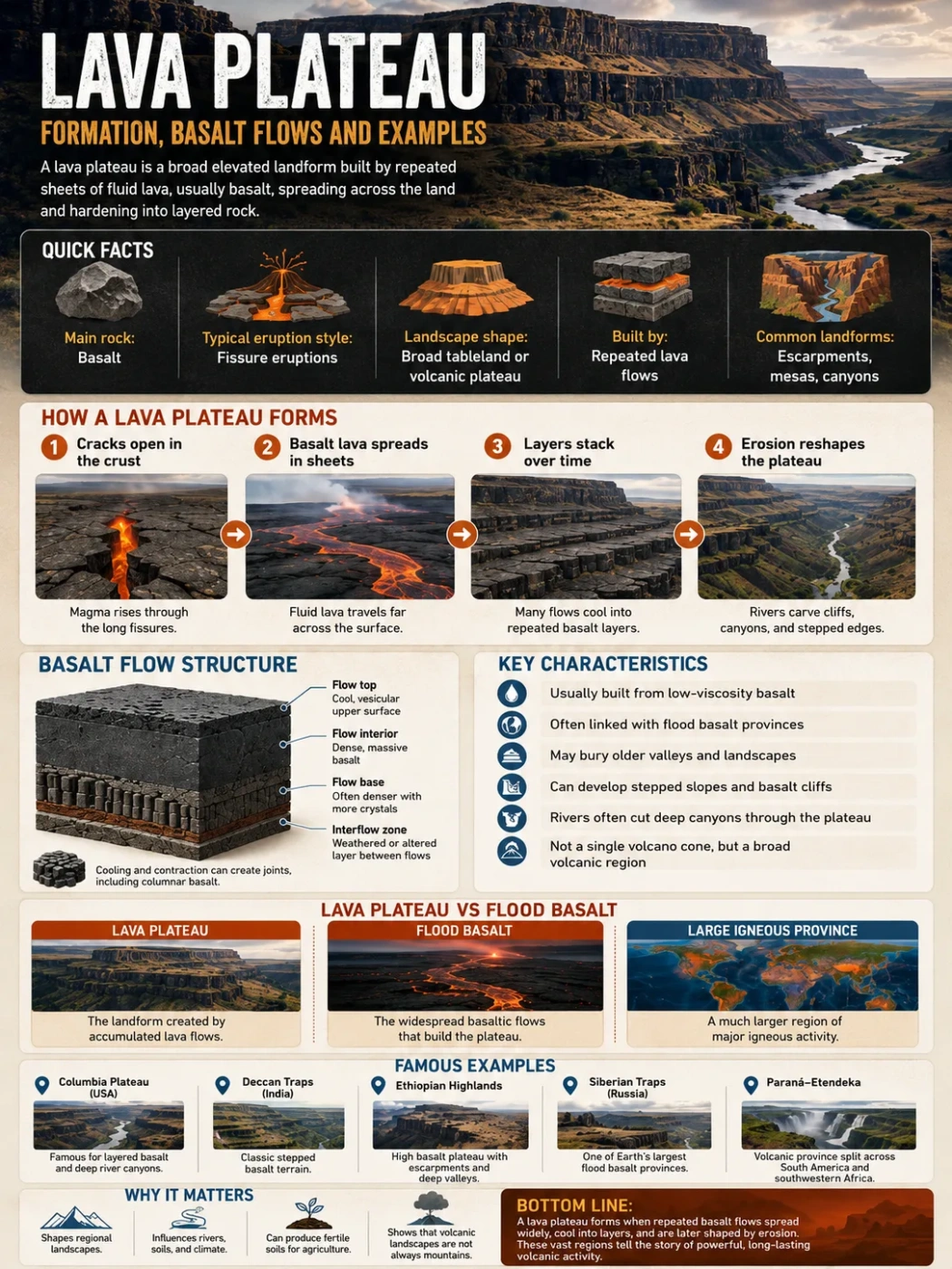
| Mixed Tectonic and Volcanic Growth | Uplift raises the region while lava flows or volcanic deposits add surface material. | High plateau terrain with volcanic plains, cones, lava fields, or ash deposits. | Plateau provinces with both uplift and volcanism |
Crustal Shortening and Thickened Crust
Some of the highest tectonic plateaus form where continental plates collide. When two thick pieces of continental crust meet, neither easily sinks into the mantle. Instead, the crust folds, breaks, stacks, and thickens. A broad region can rise like a heavy but buoyant raft.
The Tibetan Plateau is the best-known example. It sits north of the Himalayas and is often described as averaging about 4,500 meters above sea level. It formed through the long collision of the Indian and Eurasian plates. The plateau is high, wide, cold, and bordered by some of the highest mountain belts on Earth.
This kind of plateau is not just a flat surface between mountains. It is part of the mountain-building system itself.
Fault Movement and Raised Blocks
Faults can lift large blocks of crust. When this happens across a wide area, the result may be a raised plateau surface with steep edges or escarpments. Some parts may tilt. Other parts may drop, forming basins beside or within the plateau.
Fault-controlled plateaus often have sharp map patterns. A plateau edge may align with a long escarpment, a valley, or a line of springs. Rivers may follow fault zones because broken rock is easier to erode.
Thermal Uplift and Broad Swelling
Heat below the lithosphere can also lift land. Warm rock expands and becomes less dense. If the heating affects a wide region, the surface above it can rise as a broad swell.
This uplift may not create sharp mountain peaks at first. It can raise a large surface, which rivers later cut into. Over time, the plateau may gain canyons, cliffs, and dissected edges.
Geography Note
A tectonic plateau can start as a broad raised surface, then become rugged later. Rivers may cut deep valleys after uplift, especially if the plateau rises faster than drainage systems can adjust.
Why Tectonic Plateaus Can Stay Broad Instead of Becoming Mountain Ranges
Mountains and plateaus can both come from tectonic uplift. The difference is not only height. It is also shape, width, relief, and how the land is arranged.
A mountain range usually has narrow ridges, high local relief, steep slopes, and clear peaks. A plateau usually has a wider upper surface. It may stand high above surrounding land, but its interior can include plains, rolling uplands, shallow basins, and long valleys.
Several conditions help a tectonic plateau keep a broad form:
- Uplift spreads across a large crustal block instead of forming one narrow ridge.
- Sediment fills interior basins, smoothing parts of the surface.
- Erosion lowers sharp peaks while leaving higher bedrock surfaces behind.
- Dry climates slow river cutting in some plateau interiors.
- Strong rock layers resist erosion and help preserve flat or stepped surfaces.
This is why the top of a plateau may feel open and level even when its margins are steep, broken, and canyon-cut.
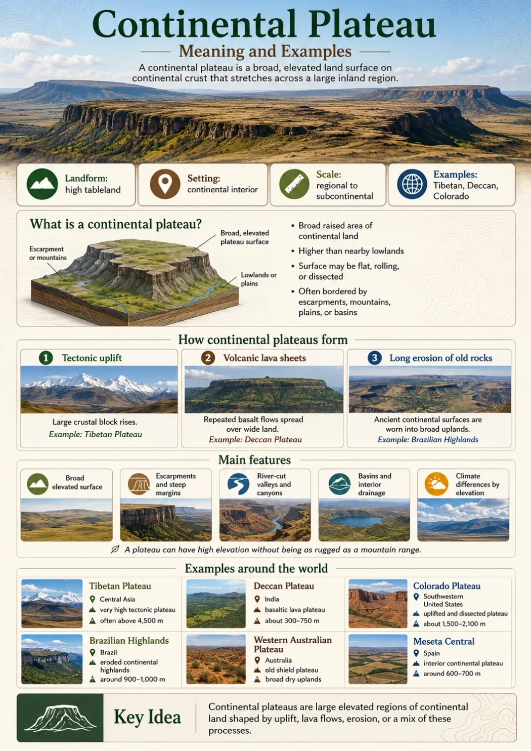
Tectonic Plateau Compared With Other Plateau Types
The term plateau describes shape, not one single origin. A plateau can form through tectonic uplift, lava flows, erosion, or a mix of processes. Knowing the formation process helps explain the landform more clearly.
| Plateau Type | Main Formation Process | Common Features | How It Differs From a Tectonic Plateau |
|---|---|---|---|
| Tectonic Plateau | Uplift, crustal thickening, faulting, or broad Earth movement | High elevation, wide surface, basins, escarpments, mountain rims | Its height is mainly tied to tectonic movement. |
| Volcanic Plateau | Repeated lava flows build a broad surface | Lava plains, basalt layers, volcanic cones, step-like edges | Its surface is mainly built by erupted material. |
| Dissected Plateau | Rivers cut into an uplifted or resistant surface | Canyons, valleys, cliffs, ridges, rugged drainage networks | It is defined by erosion pattern, not only by uplift origin. |
| Intermontane Plateau | Raised land between mountain ranges | High basins, dry interiors, enclosed drainage, salt flats in places | It is classified by position between mountains; many are tectonic too. |
| Piedmont Plateau | Uplifted land at the foot of mountains | Gentle slopes, eroded surfaces, river valleys, mountain-front margins | It is classified by location beside a mountain belt. |
Simple rule: if a plateau is high mainly because Earth movements lifted a broad area of crust, it can be described as tectonic. If it was mainly built by lava, it is volcanic. If it is mainly known for being deeply cut by rivers, it is dissected.
Common Features of Tectonic Plateaus
Tectonic plateaus vary widely, but several features appear again and again. These features help map readers and geography students identify them more confidently.
High Elevation Over a Wide Area
Many tectonic plateaus sit far above nearby plains. Some are hundreds of meters high. Others rise above 3,000 or 4,000 meters. The important point is not a single summit height, but the elevation of the broad surface.
Steep Margins and Escarpments
A plateau often has one or more steep sides. These edges may form through faulting, river erosion, or the retreat of resistant rock layers. On maps, escarpments often mark a clear break between highland and lowland.
Interior Basins
Many high plateaus contain basins. Some collect sediment from nearby mountains. Others hold lakes, wetlands, salt flats, or dry plains. These basins can make the plateau surface look smoother than the surrounding mountain terrain.
Deep River Valleys
As a plateau rises, rivers gain more cutting force. They may carve canyons, gorges, and steep valleys into the uplifted surface. This is one reason some plateaus look flat from far away but deeply broken on detailed maps.
Strong Climate Contrast
Elevation changes climate. A tectonic plateau may be cooler, drier, windier, or more seasonal than nearby lowlands. High plateaus can affect rainfall patterns, snow cover, glacier position, grassland distribution, and river flow.
Elevation Note
High elevation does not always mean mountain peaks. A plateau can be very high while still having broad valleys, open basins, and gently rolling surfaces across much of its interior.
Real Examples of Tectonic Plateaus
Real plateaus rarely fit one process perfectly. A raised plateau may also have volcanic rocks, deep river erosion, and sediment-filled basins. The examples below show how tectonic uplift can shape different plateau landscapes.
| Plateau or Region | Location | Approximate Elevation Context | Tectonic Setting | Known For |
|---|---|---|---|---|
| Tibetan Plateau | Central Asia, north of the Himalayas | Often described as averaging about 4,500 m | Continental collision and crustal thickening | Huge highland surface, cold climate, major Asian river sources |
| Altiplano-Puna Region | Central Andes, mainly Bolivia, Peru, Chile, and Argentina | Large areas sit above 3,500 m | Andean uplift, crustal shortening, volcanism, interior basins | High basins, salt flats, volcanoes, dry plateau climate |
| Colorado Plateau | Southwestern United States | Much of the region is high desert plateau terrain | Broad uplift with limited internal deformation compared with nearby ranges | Canyons, mesas, escarpments, layered rock landscapes |
| Anatolian Plateau | Türkiye, between surrounding mountain systems | Much of central Anatolia is elevated above nearby coastal lowlands | Regional uplift, compression, faulting, and volcanic activity | Interior basins, steppe landscapes, volcanic highlands |
Tibetan Plateau
The Tibetan Plateau shows the tectonic plateau idea on a very large scale. It lies north of the Himalayas and south of ranges such as the Kunlun Mountains. Its high elevation comes from the long collision between the Indian and Eurasian plates.
This plateau affects more than local topography. Its height helps shape Asian climate patterns, snow and ice storage, river headwaters, and the divide between high interior basins and lower surrounding plains.
Altiplano-Puna Region
The Altiplano-Puna region sits within the central Andes. It is a high plateau zone shaped by plate convergence, crustal shortening, volcanic activity, and basin formation. Parts of the region hold salt flats, closed drainage basins, volcanoes, and high desert landscapes.
This is a good example of a plateau where tectonic and volcanic processes overlap. The land is high because of Andean tectonics, but volcanic rocks and ash also shape many surfaces.
Colorado Plateau
The Colorado Plateau is often used to show how broad uplift and river erosion can work together. The region rose as a large block compared with nearby areas, while rivers cut deeply into its layered rocks.
Its canyons can make the region look rugged, but the wider landform is still plateau country: high, broad, layered, and deeply dissected in places.
How Tectonic Plateaus Affect Rivers and Basins
Rivers respond strongly to uplift. When land rises, streams gain gradient. That extra slope can help rivers cut downward, carry sediment, and form deep valleys. If uplift is broad, drainage systems may reorganize across a large region.
Tectonic plateaus can shape water in several ways:
- Headwater formation: high plateaus can feed major rivers through snowmelt, glaciers, springs, or seasonal rainfall.
- Interior drainage: basins may trap water instead of sending it to the sea.
- Canyon cutting: uplift can help rivers carve deep valleys into plateau surfaces.
- Sediment storage: basins collect material eroded from nearby highlands.
- Water divides: plateau surfaces may separate major river systems.
On a physical map, a tectonic plateau often appears as a high source region for rivers or as a broad inland area where streams fade into lakes, salt flats, or dry basins.
Climate and Landscape on Tectonic Plateaus
Elevation changes air temperature, rainfall, wind, and vegetation. A high plateau can be much cooler than nearby lowlands at the same latitude. It can also be dry if mountain ranges block moist air before it reaches the interior.
Common plateau climate patterns include:
- Cold highland climates on very high plateaus such as Tibet.
- Dry steppe or desert climates where rain shadows affect interior basins.
- Strong day-night temperature swings in dry, high-elevation regions.
- Short growing seasons where elevation keeps temperatures low.
- Snow, frost, or strong winds in exposed highland zones.
These conditions affect human settlement too. People often live near rivers, lake basins, sheltered valleys, grasslands, or routes that cross the plateau. Agriculture may depend on irrigation, cold-tolerant crops, or seasonal grazing.
How to Recognize a Tectonic Plateau on a Map
A tectonic plateau is easier to understand when viewed at the right scale. A street map may show roads and towns but hide the landform. A shaded relief map, elevation map, or physical atlas usually reveals it better.
Look for these clues:
- A large area of high elevation compared with surrounding lowlands.
- A broad upper surface rather than a single sharp ridge.
- Mountain ranges along one or more margins.
- Escarpments, fault lines, or steep plateau edges.
- Interior basins, salt flats, lakes, or broad valleys.
- Rivers that cut deep canyons or begin on the high surface.
Map Note
On an elevation map, a tectonic plateau may appear as a wide color zone of similar height. The edge is often easier to spot than the center, because the margin drops toward lower land.
Tectonic Plateau vs Mountain Range
A tectonic plateau and a mountain range can form in the same plate boundary system, but they are not the same landform. The difference is mainly in shape and relief.
| Feature | Tectonic Plateau | Mountain Range |
|---|---|---|
| Main Shape | Broad raised surface | Narrower belt of peaks and ridges |
| Relief | Often lower relief across the interior, with steep margins | High local relief with steep slopes and summit lines |
| Map Appearance | Wide high-elevation zone | Linear or curved chain of high peaks |
| Drainage | May include interior basins and deeply cut rivers | Streams often flow outward from ridges and valleys |
| Example Relationship | Tibetan Plateau | Himalayas along its southern margin |
A simple way to remember the difference: a mountain range is defined by peaks and ridges; a plateau is defined by a raised surface.
Common Mix-Ups
Several landform terms are close to plateau, but they do not mean the same thing. The differences are useful when reading maps, school geography texts, or landform descriptions.
Common Mix-Up
A mesa is usually a smaller, isolated flat-topped landform with steep sides. A plateau is broader. A highland is a general elevated region. A tectonic plateau is a plateau whose height is strongly tied to crustal movement.
| Term | Basic Meaning | Main Difference |
|---|---|---|
| Highland | Any elevated region | More general; not always flat enough to be called a plateau |
| Mesa | Small flat-topped hill or tableland with steep sides | Usually much smaller and more isolated than a plateau |
| Butte | Narrow isolated hill with steep sides | Smaller than a mesa and far smaller than a plateau |
| Plain | Broad low-relief land surface | May be low or high, but is not defined by raised edges |
| Escarpment | Steep slope or cliff-like edge | Often forms the side of a plateau, not the whole plateau |
| Basin | Low area that collects sediment or water | Can sit inside a plateau, especially in tectonic highlands |
Why Tectonic Plateaus Matter in Geography
Tectonic plateaus matter because they connect deep Earth processes with surface landscapes. They show how plate movement can shape rivers, climates, settlement patterns, ecosystems, and regional maps.
They also help explain why some places are high but not sharply mountainous. A plateau can influence travel routes, agriculture, water supply, weather patterns, and the location of towns. In many regions, the plateau is not just background terrain. It controls how the wider landscape works.
For map reading, the concept is especially useful. Once a plateau is understood as a raised surface rather than a single flat table, the surrounding geography becomes clearer: mountains at the edge, basins in the interior, rivers cutting through, and lowlands below.
Careful with labels: many real places combine several processes. A plateau can be tectonic, volcanic, dissected, and intermontane at the same time, depending on whether the label describes origin, surface shape, erosion, or position.
FAQ
What is a tectonic plateau?
A tectonic plateau is a broad raised landform created mainly by Earth movements such as uplift, crustal thickening, faulting, or continental collision. It has a wide elevated surface rather than only narrow peaks.
How does uplift create a plateau?
Uplift raises a large area of crust. If the rise spreads across a broad region and the surface keeps relatively low relief compared with a mountain range, the land can become a plateau. Rivers, erosion, and basins then reshape that uplifted surface.
Is a tectonic plateau the same as a mountain?
No. A mountain is usually defined by steep slopes and a clear summit. A tectonic plateau is defined by a broad elevated surface. Some plateaus sit beside mountains or form during mountain building, but they are different landforms.
Why are some tectonic plateaus so high?
Some become very high because continental collision thickens the crust and lifts a wide region. The Tibetan Plateau is the clearest example, with large areas at very high elevation north of the Himalayas.
Can a tectonic plateau also be volcanic?
Yes. Many plateaus have mixed origins. A region may rise because of tectonic uplift, while lava flows, ash deposits, or volcanic cones add new material to the surface. The Altiplano-Puna region is one example where tectonic and volcanic processes overlap.
How can I tell if a plateau is tectonic on a map?
Look for a large high-elevation area, nearby mountain belts, steep edges, fault-aligned margins, interior basins, and rivers that cut into the raised surface. These clues suggest that uplift and crustal movement helped shape the plateau.