INTERACTIVE CONTEXT MAP
Where is Meseta Central?
The selected plateau and nearby mapped locations are shown. Open the full world atlas to explore every region.
Spain · Interior Plateau System
Meseta Central forms the elevated interior of much of central Spain, but it is not one level tableland. Its broad surface is split by mountain blocks, filled by Cenozoic sedimentary basins, cut by the Duero, Tajo and Guadiana river systems, and lowered from the higher northern subplateau toward the south and west.
The Meseta Is a High Interior Region, Not a Single Flat Surface
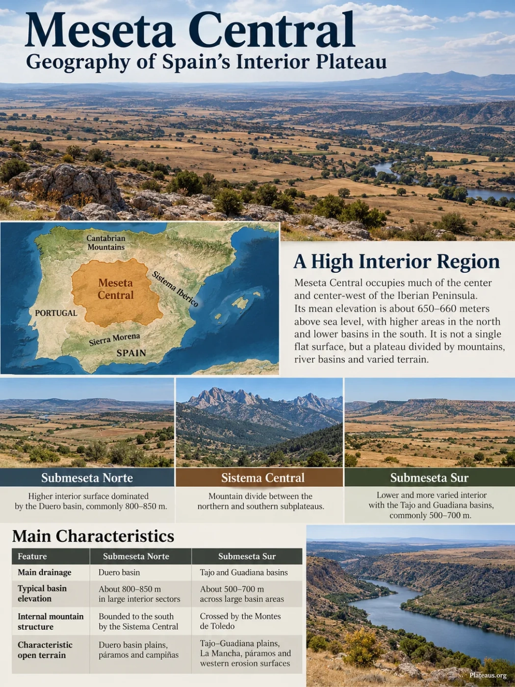
The Meseta Central occupies much of the center and center-west of the Iberian Peninsula. Spanish geographic sources commonly place its mean elevation near 650–660 meters above sea level, but that figure hides a large internal range. The Duero basin of the northern subplateau commonly lies around 800–850 meters, while large parts of the southern interior basins lie around 500–700 meters. Mountain blocks rise far above both.
Its broad margins are framed by stronger relief: the Cantabrian Mountains to the north, the Sistema Ibérico to the east and Sierra Morena along the southern edge. The western side is less like a closed wall. There, old basement surfaces and major rivers continue toward Portugal and the Atlantic.
Map Note
Meseta Central is a physiographic region rather than an administrative unit. A general map is useful for orientation, but its natural margins do not follow Spain’s autonomous-community or provincial borders exactly.
The Plateau Is Split by Mountains and River Basins
The simplest way to understand the internal shape of the Meseta is to follow its major relief divisions. The Sistema Central separates the northern and southern subplateaus. Farther south, the Montes de Toledo divides the southern interior between the Tajo and Guadiana drainage basins.
Higher interior surface dominated by the Duero basin.
Mountain divide between the northern and southern subplateaus.
Lower and more varied interior containing the Tajo and Guadiana basins.
| Feature | Submeseta Norte | Submeseta Sur |
|---|---|---|
| Main drainage | Duero basin | Tajo and Guadiana basins |
| Typical basin elevation | About 800–850 m in large interior sectors | About 500–700 m across large basin areas |
| Internal mountain structure | Bounded to the south by the Sistema Central | Crossed by the Montes de Toledo |
| Characteristic open terrain | Duero basin plains, páramos and campiñas | Tajo–Guadiana plains, La Mancha, páramos and western erosion surfaces |
Why the Meseta Stands High
The present plateau combines a very old crustal foundation with much younger relief. Much of the basement belongs to the Iberian Massif, where Paleozoic rocks were deformed during the Variscan, or Hercynian, mountain-building cycle. Granites, gneisses, slates, quartzites and other old rocks still crop out widely in the west and in uplifted mountain blocks.
Long erosion reduced much of that older mountain terrain before the current relief developed. During the Alpine orogeny in the Cenozoic, the old basement was fractured and reactivated. Some blocks rose to form interior ranges; others subsided into basins. Erosion of the rising margins then supplied sediment that progressively filled the Duero, Tajo and Guadiana depressions.
Variscan Basement Forms
Deformation, metamorphism and granite emplacement created much of the old crystalline and metamorphic foundation preserved in western and mountain sectors.
Long Erosion Lowers the Old Relief
Extended denudation produced broad erosion surfaces across parts of the old massif.
Alpine Deformation Reorganizes the Interior
Faulting and uplift raised blocks such as the Sistema Central and Montes de Toledo while adjacent depressions subsided.
Basins Fill and Rivers Cut Into the Surface
Continental sediments accumulated in the interior basins, then river incision and differential erosion created much of the modern relief.
Sistema Central Is an Interior Mountain Belt
The Sistema Central is unusual in plateau geography because it is not simply a mountain rim around the Meseta. It runs through the interior and forms the main divide between the two subplateaus. It also separates most of the Duero drainage to the north from the Tajo drainage to the south.
The range is made of a chain of sierras that includes Gata, Peña de Francia, Gredos, Guadarrama, Somosierra and Ayllón in Spain. Pico Almanzor reaches 2,591 meters in the Sierra de Gredos, far above the surrounding plateau surfaces. Granite, gneiss, slate and other old rocks dominate much of the system.
The highest sectors also preserve cold-climate landforms that are absent from the open basin plains below. Cirques, high mountain lakes, block fields and granite forms show that a plateau region can contain steep mountain terrain within its own structural interior.
Montes de Toledo Divides the Southern Meseta Again
South of the Sistema Central, the Meseta is divided a second time. The Montes de Toledo separates the Tajo basin to the north from the Guadiana basin to the south. Its relief is lower than the Sistema Central, but its effect on drainage and landscape pattern is clear.
Quartzite and slate are widespread. Because quartzite resists erosion better than adjacent weaker rocks, long parallel ridges can remain while softer belts are lowered. This produces an Appalachian-type relief in parts of the range. At the mountain foot, coarse deposits rich in quartzite fragments form surfaces known in Spain as rañas.
Páramos, Cuestas and Campiñas Shape the Sedimentary Basins
Much of the visual character of the Meseta comes from erosion of Cenozoic basin fill rather than from a perfectly level plateau surface. Horizontal or gently deformed sedimentary layers weather at different rates, producing a repeated sequence of high platforms, slopes and lower rolling plains.
A high, broad platform commonly protected by resistant limestone or another hard cap layer.
The sloping transition where erosion cuts down from the resistant upper surface.
A lower, gently rolling plain commonly developed on softer clay- and marl-rich sediments.
Where erosion isolates remnants of a former higher surface, small table-like hills or residual uplands may remain as cerros testigo or oteros. These landforms explain why large areas of Castile look stepped and open rather than uniformly flat.
The Western Meseta Exposes the Old Iberian Basement
The plateau changes westward. In parts of Zamora and Salamanca, sedimentary basin cover gives way to broad erosion surfaces cut across old granitic and metamorphic rocks. These peneplain landscapes can appear subdued from a distance even though their bedrock history is very different from the limestone-capped páramos farther east.
River incision can become much stronger near the western edge. The Duero, for example, cuts deeply into the old basement in the Arribes sector before continuing into Portugal. This contrast between a broad upland surface and a deeply entrenched river valley is one of the clearest signs that the Meseta is an elevated erosion surface rather than a simple depositional plain.
Three Atlantic Rivers Reveal the Plateau’s Westward Tilt
The Meseta has a gentle overall tilt toward the Atlantic, and its main river systems make that geometry easy to read. The Duero drains the northern subplateau. The Tajo drains much of the northern half of the southern subplateau. The Guadiana drains the southern half beyond the Montes de Toledo.
Duero and tributaries flow west toward Portugal and the Atlantic.
Tajo and tributaries cross the southern Meseta toward the Atlantic.
Guadiana drains the southern interior toward the Atlantic.
The pattern is not absolute. Parts of the eastern and southeastern margin connect to Mediterranean drainage, including sectors linked to the Júcar system. Even so, the large Atlantic basins dominate the internal organization of the Meseta.
La Mancha Is Only One Part of the Southern Meseta
La Mancha is a broad open plain of the Submeseta Sur, but it should not be used as a name for the whole southern plateau. The southern Meseta also includes the Madrid and Tajo basin landscapes, the Montes de Toledo, Campo de Montiel, western basement surfaces and the Guadiana basin.
Campo de Calatrava adds a different landform type. Here, Paleozoic slate and quartzite, Cenozoic basin sediments and younger igneous rocks occur in the same regional setting. Volcanic activity continued from the late Cenozoic into the Quaternary, adding volcanic cones, craters and lava-related terrain to a plateau more often associated with sedimentary plains.
Campo de Montiel presents a different case farther east, with large areas developed on Mesozoic carbonate rocks. The contrast shows how quickly bedrock and landform style can change within the same southern subplateau.
Climate Changes Across the Plateau With Elevation and Latitude
The Meseta has a continentalized Mediterranean climate: summers are generally dry and hot, winters can be cold, and the annual temperature range is wider than on Spain’s nearby coasts. Distance from the sea matters, but elevation and north–south position also produce strong differences within the plateau.
Representative station normals show the gradient. Valladolid, on the northern interior, is cooler and has many more frost days than Ciudad Real in the southern Meseta. Madrid sits between them climatically and topographically.
| Station | Elevation | Mean Annual Temperature | Mean Annual Precipitation |
|---|---|---|---|
| Valladolid | 734 m | 12.7°C | 433 mm |
| Madrid, Retiro | 667 m | 15.0°C | 421 mm |
| Ciudad Real | 626 m | 15.6°C | 402 mm |
Recent observations also show a warmer background climate across Spain’s interior. AEMET reported that during summer 2025, some interior areas, especially the mesetas, recorded temperature anomalies above 3°C relative to the 1991–2020 average. For Spain as a whole, the national mean temperature has risen by about 1.75°C since 1961. That national figure should not be read as a Meseta-only warming value, but it gives context for the stronger heat now affecting the interior plateau.
Meseta Central Is a Physiographic Region, Not an Administrative Unit
The boundaries of the Meseta do not match the borders of Castilla y León, the Community of Madrid, Castilla-La Mancha or Extremadura. Those political regions overlap the plateau in different ways, while the natural Meseta is defined by relief, drainage, geology and long-term landscape development.
The same distinction applies to names used inside it. Submeseta Norte is broadly tied to the Duero basin, while Submeseta Sur contains both the Tajo and Guadiana basins. La Mancha is a major plain within the southern subplateau, not a synonym for all of it. The Meseta also includes mountain blocks, old basement peneplains, sedimentary plateaus, volcanic terrain and deeply incised river valleys that do not fit the image of a single flat Castilian plain.