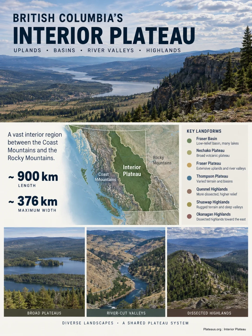
The Interior Plateau is a vast physiographic region across the southern and central interior of British Columbia, Canada. Rather than forming one continuous flat tableland, it is a system of broad uplands, lower basins, volcanic surfaces, deeply cut river valleys and increasingly dissected highlands between major mountain belts.
A Plateau System Between British Columbia’s Mountain Belts
The Interior Plateau occupies much of the broad interior zone between the Coast Mountains to the west and the Columbia Mountains and Rocky Mountain system to the east. Its northeastern side approaches the Rocky Mountain Trench, while mountain terrain also closes around its northern margins.
The scale is large even by western Canadian standards. The physiographic region is approximately 900 km long and reaches roughly 376 km at its maximum width. These dimensions describe the broad regional system rather than a sharply edged slab of elevated land.
Coast and Cascade mountain terrain rises sharply beside much of the plateau.
Broad plateaus, basins, river-cut uplands and eastern highlands occupy the interior.
Dissected highlands grade toward the Columbia Mountains and Rocky Mountain Trench.
This position helps explain several of the region’s defining characteristics. Pacific moisture must cross high mountains before reaching much of the plateau, producing a strong rain-shadow effect. At the same time, the plateau sits within an intermontane drainage network dominated by the Fraser River rather than forming a simple outward-sloping dome.
Boundary Note
The Interior Plateau is a physiographic region. Its boundaries follow changes in relief and landform character, not provincial administrative districts, settlement regions or cultural boundaries. Different small-scale maps may therefore generalize its margins differently.
Why the Interior Plateau Is Not One Flat Surface
The word plateau can give the wrong mental picture if it is taken to mean an uninterrupted plain. Large areas of the Interior Plateau do preserve flat or gently rolling uplands, but major rivers have cut deeply below those surfaces, glaciers have altered drainage, and some margins have been dissected until only smaller remnants of the old upland remain.
The result is a landscape in which broad, subdued terrain can sit close to steep valleys and canyon-like relief. The plateau identity comes from the persistence of extensive elevated surfaces and relatively even summit levels, not from every part of the region being flat.
This difference in degree of dissection also explains why plateaus and highlands appear within the same regional system. Where broad pieces of the old surface remain, the landscape retains a plateau form. Where stream erosion has cut the surface more intensively, especially toward the east, the terrain becomes a highland. Where the former surface has been almost completely removed, mountainous relief dominates.
The Interior Plateau Contains Several Distinct Physiographic Units
The regional name sits above a set of landforms that differ markedly in relief and surface character. The main classical physiographic units are the Fraser Basin, Nechako Plateau, Fraser Plateau and Thompson Plateau, together with the Quesnel, Shuswap and Okanagan highlands along the more dissected eastern side.
| Unit | Position | Landscape Character | Distinguishing Feature |
|---|---|---|---|
| Fraser Basin | North-central interior | Low-relief basin and gently rolling terrain | Heavy glacial cover, numerous lakes and poorly drained depressions |
| Nechako Plateau | West and northwest of the Fraser Basin | Broad rolling uplands with long, low ridges | Large areas remain only weakly dissected |
| Fraser Plateau | Central and south-central interior | Wide uplands broken by major river valleys | Extensive volcanic surfaces and deep Fraser River incision |
| Thompson Plateau | Southern interior | Rolling uplands with stronger valley relief | Greater dissection by the Thompson-Okanagan drainage system |
| Quesnel Highland | Eastern side | More strongly dissected elevated terrain | Transition from plateau surfaces toward mountain relief |
| Shuswap Highland | Southeastern side | Rugged highland with smaller remnants of upland surfaces | Deep dissection and higher relief |
| Okanagan Highland | Southern and southeastern side | Dissected uplands adjoining interior valleys and mountains | Part of the gradual eastern plateau-to-mountain transition |
The Fraser Basin Sits Below the Surrounding Plateau Surface
The Fraser Basin is an important reminder that a major plateau region can contain extensive lower terrain. Much of the basin lies below the adjoining Nechako Plateau and has a flat to gently rolling surface mantled by glacial deposits.
Bedrock is commonly hidden beneath drift. Drainage across parts of the surface is poorly organized, leaving many lakes, wetlands and closed or weakly drained depressions. The Fraser River and its tributaries cut through this subdued terrain rather than simply following a uniform plateau slope.
The Nechako Plateau Preserves Broad Uplands
The Nechako Plateau contains large expanses of relatively low-relief country. Long, subdued ridges, gently rolling uplands and extensive glacial cover are characteristic. In some areas, drainage networks are sparse compared with more deeply dissected parts of the Interior Plateau.
The subdued topography should not be mistaken for a young depositional plain. Much of the regional form reflects an older erosional landscape that was later uplifted, modified by volcanism and then heavily reworked by glaciation.
The Fraser Plateau Shows the Contrast Between Upland and Canyon
The Fraser Plateau contains some of the clearest examples of broad upland surfaces divided by deep river incision. Much of the Chilcotin and Cariboo country belongs to this broader plateau setting. Large sections of upland commonly lie around 1,200 to 1,500 m, although elevation varies considerably across the wider physiographic region.
The Fraser River and lower Chilcotin River cut far beneath adjacent plateau surfaces in places. This creates a strong local contrast: relatively gentle country can extend across the upland while steep valley walls expose the vertical structure of lava flows, older bedrock and glacial sediments.
The Thompson Plateau Is More Intensely Divided by Valleys
Farther south, the Thompson Plateau has greater local relief and a more segmented appearance. Deep valleys associated with the Thompson system divide rolling uplands into smaller blocks. Glacial benches, terraces and later river channels add further complexity along the major valleys.
The Eastern Highlands Record Increasing Dissection
The Quesnel, Shuswap and Okanagan highlands represent the transition between broad plateau country and more mountainous terrain. Their inclusion within the Interior Plateau is therefore informative: the regional system is defined by landscape evolution and preserved upland surfaces, not simply by flatness.
The eastward transition is comparatively broad because erosion has progressively broken the former surface into smaller, higher remnants. Along much of the western edge, by contrast, the change from plateau to the Coast Mountains is more abrupt.
How an Old Low-Relief Landscape Became the Modern Plateau
The present Interior Plateau cannot be explained by a single uplift event or a single episode of volcanism. Its large-scale form developed through a sequence of erosion, lava emplacement, regional uplift, river incision and glaciation.
A Broad Low-Relief Surface Developed
Long periods of stream erosion reduced much of the interior landscape to broad surfaces with relatively subdued relief. Older British Columbia physiographic literature refers to the surviving remnants as a late Tertiary erosion surface; in modern time terminology, this belongs to the late Cenozoic evolution of the region.
Lava Covered Parts of the Older Landscape
Volcanic eruptions spread lava across extensive areas of the Fraser and Nechako plateaus. Basalt filled some older valleys and produced broad, low-relief volcanic surfaces over parts of the existing terrain.
Regional Uplift Re-Energized Rivers
Differential uplift raised the old surface by different amounts across the region. River gradients increased, allowing streams to cut downward into the elevated landscape.
The Cordilleran Ice Sheet Overrode the Plateau
Repeated glaciation covered the interior with thick ice. Moving ice reshaped the surface, redistributed sediment and altered drainage, while deglaciation produced lakes, meltwater channels and widespread glacial deposits.
Rivers Continued to Cut Through the Uplands
Modern drainage inherited a landscape already shaped by uplift and ice. Rivers continued incision, while glacial sediments remained across large areas of the plateau surface and basin floors.
Landform Classification
Volcanic rocks are widespread across parts of the Interior Plateau, especially within the Fraser and Nechako plateau regions, but the entire Interior Plateau is not simply one volcanic plateau. Its form reflects erosion surfaces, uplift, volcanism, river dissection and glaciation acting together.
River Incision Explains the Plateau’s Strongest Relief Contrasts
Once the old surface was uplifted, rivers could cut into it. The amount of incision was not equal everywhere, so different parts of the Interior Plateau developed very different relief.
Western portions of the Fraser and Nechako plateaus retain large areas of relatively intact upland. The Thompson Plateau is more strongly segmented. The eastern highlands have been dissected much more deeply, leaving smaller remnants of the former surface between valleys.
This produces an important geomorphic pattern:
Large areas of gently sloping terrain survive where incision and dissection remain limited.
Streams cut below the elevated surface as regional relief increases.
Where dissection becomes strong, steep slopes occupy more of the terrain and plateau remnants shrink.
A deep canyon therefore does not contradict the presence of a plateau. It can be evidence that a river has cut through an older elevated surface whose remnants remain on either side.
Glaciation Still Controls Much of the Surface Detail
The Cordilleran Ice Sheet crossed the Interior Plateau after the major upland and valley pattern had already begun to develop. Ice did not erase that older landscape, but it strongly modified it.
Glacial drift now blankets large areas and can obscure the underlying bedrock. This cover is especially important in central British Columbia, where geological mapping and mineral exploration may have to interpret bedrock hidden beneath till and younger volcanic material.
Drumlins Record Former Ice Movement
Streamlined hills and drumlin-like forms occur in glacial sediments, particularly across the Fraser Basin and other central plateau surfaces. Their orientation preserves evidence of former ice-flow directions across terrain that today may appear almost static.
Eskers Mark Meltwater Routes Beneath the Ice
Long ridges of sand and gravel formed where meltwater streams flowed within or beneath wasting ice. Some esker systems in the Fraser Basin extend for many kilometres, showing that deglaciation involved organized meltwater drainage as well as simple ice retreat.
Glacial Lakes Left Flat Sediment-Filled Areas
As ice wasted away, older drainage routes were sometimes blocked by ice or glacial debris. Temporary lakes occupied parts of the interior, depositing fine sediments across basin floors. Former glacial-lake surfaces contribute to the unusually flat character of some lowlands.
Depressions Became Lakes and Wetlands
Irregular glacial deposition and disrupted drainage left numerous shallow depressions. Many remain occupied by lakes, ponds and wetlands, particularly across low-relief central and northern parts of the system.
The Fraser River Organizes Most of the Plateau’s Drainage
Almost the entire Interior Plateau drains through the Fraser River and its tributaries. This gives the river a role far larger than that of a single valley crossing the region: the Fraser is the main drainage spine connecting much of the plateau to the Pacific.
The Nechako River enters the Fraser at Prince George, linking a large part of the north-central plateau to the main system. Farther south, tributaries including the Chilcotin and Thompson drain major sections of the plateau and deepen the regional pattern of incision.
Only smaller portions of the wider physiographic region drain toward other major river systems, including the Skeena, Peace and Columbia. Drainage divides near the margins therefore reflect the Interior Plateau’s position among several large mountain and river systems.
The drainage pattern is particularly revealing in the Fraser Basin. Broad low-relief surfaces contain numerous lakes and poorly drained depressions, yet the Fraser itself is entrenched below parts of that surface. Regional drainage can therefore be strongly integrated even where local surface drainage remains irregular.
A Strong Climate Gradient Crosses the Plateau
The Interior Plateau lies largely in the rain shadow of the Coast Mountains. Moist Pacific air loses much of its moisture while crossing the western mountains, so parts of the interior are markedly drier than coastal British Columbia.
The effect is not uniform. Precipitation is generally lower across the western and southern parts of the plateau and increases toward wetter eastern highlands and northward into central British Columbia. Elevation, exposure and proximity to mountain barriers add substantial local variation.
Warm, dry valleys and lower uplands support grassland, open forest and some of the strongest moisture deficits within the region.
Lower temperatures at elevation favor cooler montane forests even where the regional climate remains relatively dry.
Colder winters, greater moisture in many areas and extensive glaciated low-relief terrain support broad conifer forests, lakes and wetlands.
A single temperature or precipitation figure would therefore describe the Interior Plateau poorly. The region crosses enough latitude, elevation and terrain to contain distinctly different climatic settings within the same physiographic system.
Vegetation Follows the Plateau’s Moisture and Elevation Pattern
The ecological contrast from southern grasslands to central sub-boreal forest closely follows the physical geography. Latitude matters, but so do elevation, rain-shadow intensity, slope exposure and local moisture.
Dry Southern Uplands and Valleys
Much of the southern Interior Plateau overlaps the Interior Douglas-fir climatic zone. Rolling terrain may carry dry grasslands, open Douglas-fir stands and denser forest on cooler or wetter sites. Some lower valleys become still warmer and drier.
Cool Plateau Forests at Higher Elevations
Montane spruce environments become important on cooler middle-elevation surfaces in the south-central interior. Plateau topography allows this climatic belt to cover broad areas rather than being confined to narrow mountain slopes.
Sub-Boreal Forest Across the Central Interior
The Sub-Boreal Spruce zone occupies extensive gently rolling terrain across the central Interior Plateau, including parts of the Nechako and Quesnel uplands and the Fraser Basin. Spruce, lodgepole pine and other cold-tolerant forest communities occur among a dense network of lakes, rivers and wetlands.
The ecological pattern reinforces a central feature of the Interior Plateau: it is too large and internally varied to be represented by a single landscape type. Dry open country in the south and lake-rich forested terrain farther north can both belong to the same physiographic region.
Soils Preserve the Combined Effects of Bedrock, Ice and Climate
Much of the Interior Plateau is covered by glacial material rather than exposed bedrock. Till, glaciofluvial sand and gravel, and fine glacial-lake sediments form the parent material for many modern soils.
Volcanic rocks also influence soil chemistry in areas where basaltic material contributes to the parent sediment. In other places, thick glacial deposits weaken the visible relationship between the surface soil and the bedrock directly beneath it.
Climate then changes the way those materials develop. Drier southern landscapes can support grassland-associated soils, while cooler and wetter forested parts of the central and northern plateau develop different soil profiles. Wet depressions add organic soils to the mosaic.
The resulting soil pattern is therefore not random. It records the same controls visible in the larger landforms: geology, glaciation, relief, drainage and climate.
Volcanic Terrain Is Important but Geologically Uneven
Volcanism is one of the most visible geological influences on the Interior Plateau, especially across the Fraser and Nechako plateau regions. Broad lava sheets locally form resistant, nearly horizontal surfaces, while river incision exposes steep edges and stacked volcanic sequences.
Volcanic construction was not uniform. The plateau contains older sedimentary, volcanic, intrusive and metamorphic rocks alongside younger Cenozoic volcanic units. In some places resistant intrusive rocks stand above the surrounding upland as isolated mountains, while volcanic centres rise above otherwise subdued plateau surfaces.
This varied bedrock also helps explain why erosion has produced different landforms from place to place. A plateau surface can cross several rock types because part of its geometry comes from an old erosion surface rather than from one continuous geological formation.
Several Similar Geographic Names Describe Different Things
The name Interior Plateau is easy to confuse with broader regional terms and with the Columbia Plateau farther south. Keeping those names separate prevents a major geographic error.
Interior Plateau
A named physiographic region centred in southern and central British Columbia. It includes major plateaus, the Fraser Basin and a belt of eastern highlands.
British Columbia Interior
A much broader regional expression for inland British Columbia. It is used in geographic, cultural, climatic and administrative contexts and does not have the same strict physiographic meaning as Interior Plateau.
Interior Mountains
A separate physiographic grouping farther north. The similarity of the names does not make the Interior Plateau part of the Interior Mountains.
Columbia Plateau
A major physiographic and volcanic region centred mainly in Washington and Oregon and extending into Idaho. It is strongly associated with the Columbia River Basalt Group and should not be treated as another name for British Columbia’s Interior Plateau.
How the Interior Plateau Appears on the Ground
No single view represents the entire region, but several recurring landform combinations help identify Interior Plateau terrain.
- Broad rolling skylines where remnants of the old upland surface remain only lightly dissected.
- Long, low ridges across parts of the Nechako and central plateau country.
- Deep river valleys cut far beneath otherwise gentle uplands.
- Flat-topped or gently dipping volcanic surfaces where lava flows dominate the local geology.
- Glacially streamlined terrain with drumlins and other ice-flow forms.
- Lake- and wetland-rich depressions where postglacial drainage remains poorly integrated.
- Dry grassland and open forest in parts of the southern interior.
- Extensive conifer forest across cooler central and northern plateau surfaces.
- Increasingly rugged highlands where the eastern plateau has been deeply dissected toward the Columbia Mountains.
The most diagnostic pattern is the relationship between these features rather than any one of them alone: large remnants of elevated, low-relief terrain interrupted by valleys, glacial landforms and locally stronger volcanic or highland relief.