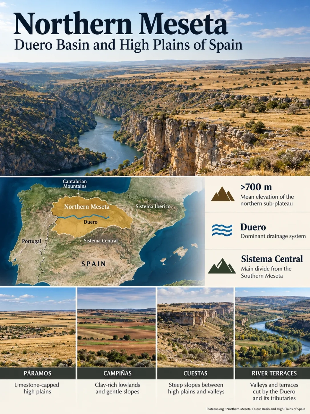
Spain · Meseta Central · Duero Basin
The Northern Meseta, also called the Meseta Norte or Submeseta Norte, is the higher northern division of Spain’s Meseta Central. Its broad surface is organized around the Duero basin, but it is not one uniform plain: limestone-capped páramos, clay-rich campiñas, cuestas, river terraces, residual hills and old western peneplains occupy different parts of the plateau.
Mean elevation of the northern sub-plateau
Dominant drainage system
Main divide from the Southern Meseta
The Northern Meseta Is a High Interior Basin
The Northern Meseta occupies the part of the Meseta Central north of the Sistema Central. Much of it lies within Castilla y León, where a broad elevated surface surrounds the middle course of the Duero and many of its tributaries. Spanish geographic descriptions place the mean elevation of the northern sub-plateau above 700 metres, making it higher overall than the Southern Meseta.
The simple description of a “high plain” is useful only as a starting point. The Northern Meseta contains several generations of landforms. The centre is dominated by Cenozoic sedimentary terrain, while much older Paleozoic rocks appear toward the western peneplains and around parts of the mountain rim. Rivers have then cut into both surfaces, producing terraces, valleys, isolated remnants and, at the western edge, deep gorges.
The Mountain Rim Is Strongest to the North, East and South
- North: the Cantabrian Mountains and associated uplands rise above the Duero basin.
- East: the Sistema Ibérico forms a high divide between the Duero drainage and adjoining basins.
- South: the Sistema Central separates the Duero basin from the Tajo side of the Meseta.
- West: the plateau passes into the Zamora–Salamanca peneplain before the Duero descends toward Portugal through the Arribes gorge system.
Boundary Note
Northern Meseta, Duero Basin and Castilla y León are not interchangeable names. The Northern Meseta is a physical-geography region. Castilla y León is an administrative territory. The international Duero drainage basin covers about 98,073 km², including about 78,859 km² in Spain, and also includes mountain terrain and Portuguese territory outside the Northern Meseta in the strict geomorphic sense. A Duero basin area figure should therefore not be presented as the area of the plateau.
Why a Plateau Can Also Be a Sedimentary Basin
The Northern Meseta is elevated when viewed against the Iberian Peninsula as a whole, yet much of its interior is also a Cenozoic sedimentary depression. These descriptions refer to different scales. “Plateau” describes the broad high surface; “basin” describes the geological structure beneath much of that surface.
The deeper foundation belongs to the old Iberian or Hesperian Massif. Paleozoic rocks were deformed during the Variscan orogeny and later worn down by long periods of erosion. Cenozoic tectonic deformation then reorganized central Iberia. Blocks rose around the basin while the Duero depression developed between them.
Paleozoic rocks were folded, metamorphosed and intruded by granites, creating the ancient basement beneath much of the Meseta.
Older mountain relief was reduced, leaving broad erosion surfaces that remain especially visible in the west.
Alpine-age deformation raised surrounding mountain systems while the Duero depression received sediment from their erosion.
Later drainage cut into the basin fill, separating higher limestone surfaces from lower clay and marl plains.
The sediment filling the basin did not come from a single source or environment. Rivers, alluvial fans and lakes deposited conglomerate, sand, clay, marl, gypsum and limestone at different times and positions. This is why the modern relief changes even where the surface appears broadly level.
The northern margin near Palencia preserves a particularly clear record of basin development. Thick conglomerate successions were deposited by ancient alluvial fans spreading from the rising Cantabrian margin into the subsiding Duero basin. These deposits record mountain uplift and basin filling as connected processes rather than separate events.
Páramo, Cuesta and Campiña Form the Characteristic Interior Relief
Much of the central Northern Meseta can be read as a sequence created by differential erosion. Resistant limestone protects some higher surfaces, while softer marl and clay beneath it erode more readily. The result is a recurring association of páramos, cuestas and campiñas.
Higher, relatively level surface commonly protected by resistant limestone.
Slope or stepped transition where erosion cuts through the harder cap into softer beds.
Lower rolling plain developed mainly across softer clay and marl.
Isolated residual hill left behind as a former higher surface is dismantled.
The sequence is conceptual rather than a scale cross-section. Local rock layers, river incision and erosion history vary across the basin.
| Landform | Typical Material or Structure | Position in the Landscape | Surface Expression |
|---|---|---|---|
| Páramo | Resistant limestone above softer sediment | Higher parts of the sedimentary basin | Broad, flat-topped or gently rolling upland |
| Cuesta | Limestone, marl and clay sequence | Edges below páramo surfaces | Sloping or stepped transition |
| Campiña | Clay, marl and other relatively soft sediment | Lower central plains | Open, gently rolling agricultural terrain |
| Cerro testigo | Residual resistant cap over softer beds | Isolated within lower eroded terrain | Detached hill preserving part of an older surface |
| Western peneplain | Granite and metamorphic Paleozoic basement | Zamora–Salamanca sector and western margins | Low-relief erosion surface locally cut by deep valleys |
Páramos Preserve Former Higher Surfaces
A páramo in this setting is not simply any treeless upland. It is commonly a relatively level surface protected by a more resistant limestone layer. The softer marl and clay below are more easily removed, so erosion gradually isolates the higher cap from the surrounding lower terrain. The Cerrato area is one of the landscapes where this arrangement can be read clearly.
Campiñas Occupy the Softer Lower Terrain
Where the resistant cover has been removed, erosion works across softer sediment and produces lower, smoother country. These campiñas form some of the broadest agricultural landscapes of the Northern Meseta. Tierra de Campos is a well-known example, with widespread clay-rich terrain and extensive cereal cultivation.
Residual hills show that the present campiña surface was not always as low as it is now. Near Ataquines in Valladolid, a group of cerros testigo rises roughly 30–40 metres above the surrounding plain. Their position records the progressive removal of material around them.
The Western Peneplains Expose an Older Landscape
The interior sedimentary basin does not continue unchanged to the Portuguese border. Toward western Zamora and Salamanca, older rocks of the Iberian Massif become much more prominent. Granite, slate, quartzite and other Paleozoic materials form broad peneplain surfaces produced by long erosion of ancient terrain.
This western landscape is generally less dependent on the limestone–marl layering that produces the classic páramo and campiña relief farther east. Rock resistance, fractures and river incision become more visible controls on landform shape.
Arribes del Duero Cuts Deep Into the Western Surface
The contrast is strongest where the Duero approaches Portugal. After crossing the broad interior plains, the river becomes deeply incised into resistant Paleozoic rocks along the international border. The Arribes gorge system extends for roughly 100 kilometres along the Duero sector, with canyon walls and deeply cut tributary valleys locally reaching several hundred metres of relief.
This is one of the clearest demonstrations that a plateau does not have to remain flat at its edge. The regional surface is still elevated, but the river has cut far below it while descending from the Castilian plateau toward lower Portuguese terrain.
Landform Distinction
The central campiñas and the western peneplain may both appear broad and open, but they have different geological origins. Campiñas are mainly erosional lowlands developed within younger basin sediment. The western peneplain exposes much older crystalline and metamorphic basement that was worn down before the modern Duero valley became deeply entrenched.
The Surface Tilts Toward the Atlantic
The Meseta has a broad westward tilt, and the Northern Meseta follows that regional pattern. Many eastern and north-eastern interior surfaces stand around 800–900 metres, while lower levels occur farther west. The gradient is gentle across much of the plateau, but over hundreds of kilometres it is enough to organize the main drainage toward the Atlantic.
The Duero rises in the eastern highlands of the Sistema Ibérico and crosses the Northern Meseta toward Portugal. Its drainage network collects water from nearly the entire northern sub-plateau before the river ultimately reaches the Atlantic at Porto.
Elevation Note
A single “typical elevation” cannot describe every part of the Northern Meseta. The mean elevation of the northern sub-plateau exceeds 700 metres, but basin floors, páramo surfaces, western peneplains and the surrounding mountain margins occupy very different levels. Mountain peaks around the basin should not be treated as representative plateau-surface elevations.
The Tributaries Reveal the Shape of the Basin
The drainage network is strongly asymmetric because the mountains around the basin sit at different distances from the Duero. The Esla and Pisuerga systems drain large northern sectors, while the Duratón, Adaja and Tormes bring water from southern and south-western areas. Smaller rivers and seasonal channels further divide the sedimentary plains.
River valleys also interrupt the visual continuity of the plateau. Their floors can lie well below adjacent páramo surfaces, creating local relief that is easy to miss on small-scale maps.
Older Channels Survive Inside the Basin Fill
The modern Duero network is only the latest stage of a much longer drainage history. At Miño de San Esteban in Soria, sedimentary exposures preserve a Miocene paleochannel cut into older basin deposits and later filled by new material. Such features show that rivers were repeatedly changing course, eroding and redepositing sediment while the Duero basin was still evolving.
Quaternary river terraces provide a younger record of the same principle. A terrace marks a former floodplain or channel level that was abandoned when a river cut downward. Sets of terraces therefore preserve steps in the progressive incision of the drainage network into the plateau.
Elevation and Continentality Produce Cold Winters
The Northern Meseta lies far from the moderating influence of Spain’s coasts and stands hundreds of metres above sea level. The combination produces a strongly continental interior climate within the broader Mediterranean climatic setting: winters are cold and frost-prone, summers are generally dry and warm to hot, and day-to-night temperature ranges can be large.
The surrounding relief also affects moisture. Atlantic weather systems can enter from the west, but rainfall is not distributed evenly across the plateau. Mountain margins are generally wetter than much of the central basin, while local elevation and exposure create further contrasts.
| Station | Elevation | Mean Annual Temperature | Mean Annual Precipitation | Mean Frost Days per Year |
|---|---|---|---|---|
| Valladolid | 734 m | 12.7°C | 433 mm | 56.2 |
| Burgos Airport | 891 m | 10.7°C | 546 mm | 80.9 |
These are station records rather than averages for the whole Northern Meseta. Their contrast is useful because it shows how elevation and position within the plateau alter local climate. Burgos stands higher and records a lower annual mean temperature and more frost days, while Valladolid represents a lower and drier part of the interior basin.
Winter Inversions Help Produce Persistent Fog
Cold, calm winter weather can trap dense air near the floor of the Duero basin while warmer air remains above it. This temperature inversion suppresses vertical mixing and can support long-lasting low cloud or fog. Valladolid’s 1981–2010 climate normal records about 40 fog days per year, illustrating how common this basin-weather pattern can be.
The process also explains why a low basin floor may sometimes be colder during a winter night than a nearby slope. Elevation alone does not control minimum temperature when cold air is pooling in valleys and plains.
Recent Warming Adds Heat to an Already Dry-Summer Climate
Recent meteorological records place the Northern Meseta within the broader warming pattern affecting inland Spain. Much of Castilla y León was classified as extremely warm during 2025, while large parts of the Spanish interior were again extremely warm in spring 2026. Spain’s summer of 2026 became the warmest in the national series beginning in 1961.
These individual seasons should not be treated as a replacement for long climate normals. Their geographic relevance is that warmer conditions can raise evaporation and soil-moisture demand across a region where summer rainfall is already limited and agriculture depends strongly on seasonal water availability.
Soils and Farming Follow the Relief
The agricultural pattern of the Northern Meseta is closely tied to its geomorphology. Broad campiñas provide extensive workable surfaces, and their clay-rich sediment has long supported dry farming. This relationship is especially visible in Tierra de Campos, where open cereal fields spread across low-relief terrain developed on Cenozoic deposits.
Campiñas
Cereal Plains
Broad clay and marl surfaces are widely cultivated, especially where low relief allows large continuous fields. Wheat and barley are characteristic crops of these dry-farming landscapes.
River Valleys
Alluvial and Irrigated Land
Valley floors and river terraces contain younger alluvial soils and easier access to water. Irrigation creates a more varied crop pattern than on surrounding dry uplands.
Duero Corridor
Vineyard Landscapes
Vineyards occupy selected terraces, valley margins and sedimentary surfaces along parts of the Duero, including the Ribera del Duero sector, where soil, slope, elevation and local climate combine differently from the open cereal plains.
Páramo tops often carry thinner, stonier soils than the lower campiñas, while western siliceous terrain produces a different soil and vegetation pattern again. Remnants of holm oak woodland, pine stands, grassland and riparian vegetation therefore occur within a landscape heavily modified by farming.
The contrast between dry farming and irrigated land also shows why the Northern Meseta cannot be understood through climate alone. The same regional climate can support very different land uses where soil depth, groundwater, river access and irrigation infrastructure change from one part of the plateau to another.
The Northern and Southern Meseta Are Not Mirror Images
The Sistema Central separates two related but differently organized plateau regions. Both belong to the Meseta Central, yet their elevation, drainage and internal relief are not arranged in the same way.
Northern Meseta
- Mean elevation above 700 m.
- Organized mainly around the Duero basin.
- Contains a broad Cenozoic sedimentary depression surrounded by mountain margins.
- Páramos, cuestas and campiñas are characteristic interior forms.
- Western drainage passes into deeply incised Duero gorges before reaching Portugal.
Southern Meseta
- Mean elevation is commonly described around 600 m.
- Drainage is divided mainly between the Tajo and Guadiana systems.
- The Montes de Toledo create a strong internal subdivision.
- Its sedimentary plains and older basement surfaces follow a different spatial arrangement.
- The plateau extends farther south into lower and generally warmer interior terrain.