INTERACTIVE CONTEXT MAP
Where is Pamir Plateau?
The selected plateau and nearby mapped locations are shown. Open the full world atlas to explore every region.
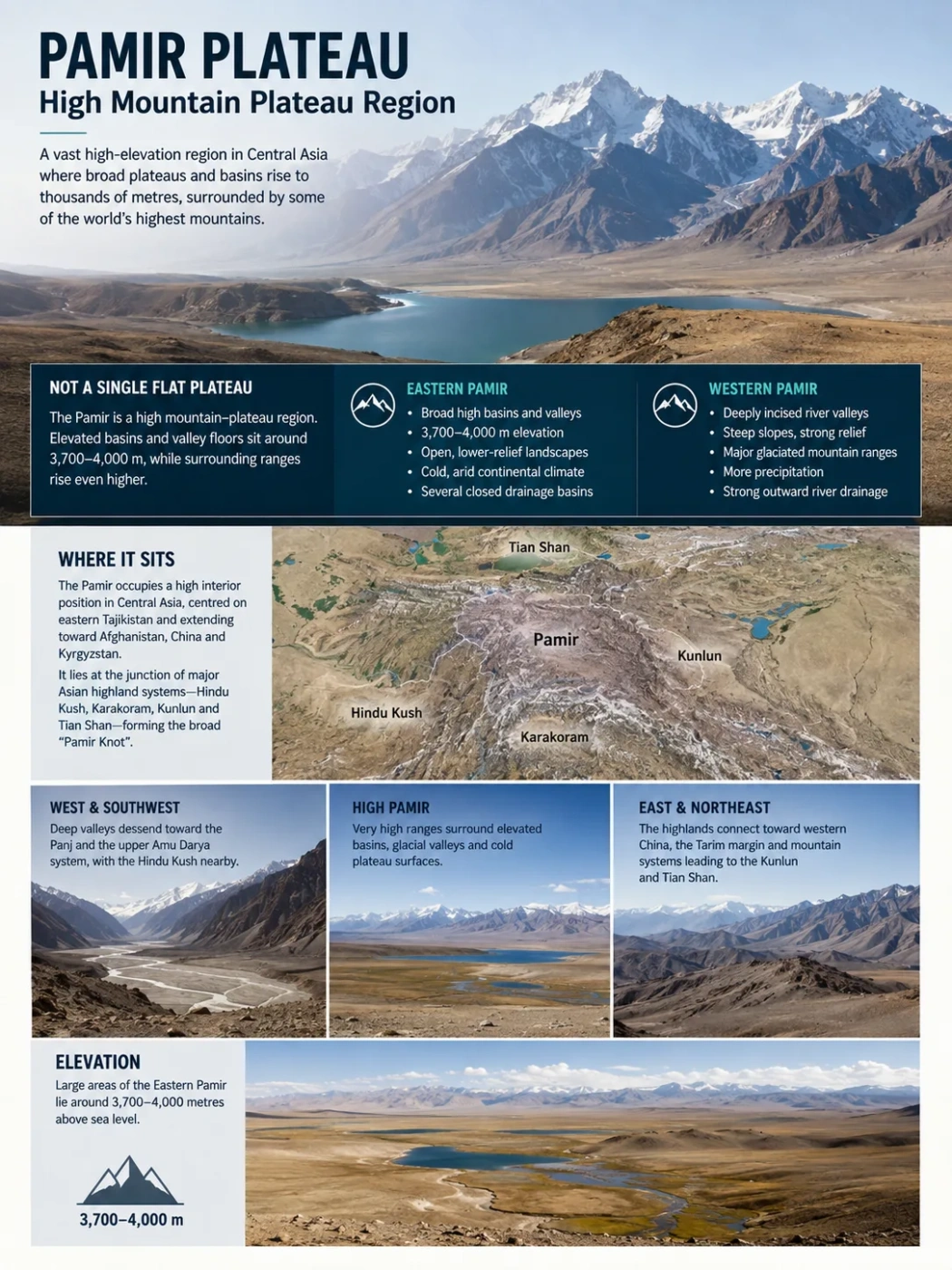
The Pamir is often called a plateau, yet much of it looks unmistakably mountainous. The apparent contradiction comes from its unusual relief: broad high basins and valley floors, especially in the Eastern Pamir, sit thousands of metres above sea level while surrounding ranges rise into some of Central Asia’s highest terrain. The result is not a single flat upland, but a high mountain–plateau region shaped by continental collision, glaciers, deep river incision and extreme continental climate.
The Pamir Is Not a Single Flat Plateau
Pamir Plateau is useful as a regional name, but it should not be read as meaning that the entire Pamir is one continuous level surface. The plateau character is strongest in the east, where large basins, wide valleys and relatively open high ground commonly lie around 3,700–4,000 metres above sea level. Mountain ranges rise above those surfaces, but the floors between them remain unusually high.
The Western Pamir has a different form. Rivers have cut deeply into the uplifted terrain, producing narrow valleys and steep mountain walls with very large differences in elevation over short horizontal distances. High peaks and glaciers dominate the skyline, while broad plateau-like surfaces are less prominent.
Landform Distinction
Pamir Mountains, Pamir Plateau and High Pamir overlap in everyday geographic usage, but they do not describe exactly the same landform. “Pamir Mountains” emphasizes the wider mountain system. “Pamir Plateau” is most physically convincing where high basin floors and broad uplands dominate, particularly in the Eastern Pamir.
Eastern Pamir
- Broad high basins and valley floors
- Large areas around 3,700–4,000 m
- More open, lower-relief interior landscapes
- Cold and strongly arid conditions
- Several closed drainage basins
Western Pamir
- Deeply incised river valleys
- Steep slopes and much stronger local relief
- Major glaciated mountain ranges
- More precipitation than the eastern interior
- Strong outward river drainage
Where the High Pamir Sits in Central Asia
The Pamir occupies a high interior position in Central Asia, centred on eastern Tajikistan and extending toward northeastern Afghanistan, western China and southern Kyrgyzstan. Exact boundaries vary because the Pamir is a physical region rather than a single administrative unit.
Its position matters as much as its elevation. The Pamir lies where several of Asia’s great highland systems approach one another. The Hindu Kush extends toward the southwest, the Karakoram lies to the southeast, the Kunlun system continues eastward, and the Alay and Tian Shan highlands lie to the north and northeast. This setting helped produce the expression “Pamir Knot”.
Deep valleys descend toward the Panj and the upper Amu Darya system, with the Hindu Kush nearby.
Very high ranges surround elevated basins, glacial valleys and cold plateau surfaces.
The highlands connect toward western China, the Tarim margin and mountain systems leading toward the Kunlun and Tian Shan.
“Pamir Knot” is best understood as a broad physiographic description rather than a literal point where several mountain chains meet at one exact coordinate. The region is a complex zone of ranges, faults, basins and high surfaces developed within the wider India–Eurasia collision system.
Eastern Pamir: Where the Plateau Character Is Strongest
The Eastern Pamir contains some of the clearest examples of why the region is described as a plateau. High mountain ranges still cross the landscape, but between them lie broad basins and valleys whose floors are already at elevations comparable with many mountain summits elsewhere in the world.
Research areas around Karakul, Rangkul and Bulunkul have been described as a mountainous plateau roughly 3,700–4,000 metres above sea level. These are not smooth plains. Alluvial fans, old glacial deposits, lake basins, river terraces, frost-shaped ground and isolated mountain ridges break the surface. What gives the area its plateau character is the high regional base level and the large horizontal extent of elevated terrain.
A useful distinction is therefore between absolute elevation and local relief. A valley floor at nearly 4,000 metres is exceptionally high in absolute terms even if nearby slopes rise another 1,000 or 2,000 metres. The Pamir can consequently be both a high plateau region and a major mountain system.
Elevation Note
A single “Pamir Plateau elevation” can be misleading. High basin and valley surfaces in the Eastern Pamir commonly occupy the upper 3,000-metre range and above, surrounding ranges exceed 5,000–6,000 metres, and several Pamir summits rise beyond 7,000 metres. These values describe different parts of the relief and should not be treated as interchangeable averages.
Western Pamir: A Plateau Cut Into High Mountains
Moving west, the terrain becomes far more deeply dissected. Rivers have cut through the uplifted crust, leaving steep ridges separated by narrow valleys and gorges. In places, the difference between river level and neighbouring summits reaches several kilometres.
This change is partly linked to moisture. Westerly air masses deliver more precipitation to the western side of the Pamir than to the dry eastern interior. Greater snowfall supports extensive high-altitude ice, while stronger runoff helps rivers and glaciers erode the landscape. The result is a much more rugged surface.
That contrast explains why photographs of different parts of the Pamir can appear to show completely different landform regions. An open basin in the east may resemble a cold high plateau, while a western valley can resemble a deeply glaciated alpine mountain belt. Both belong to the same broader highland system.
How Continental Collision Built the Pamir Highlands
The Pamir is part of the broad zone of crustal deformation created by the collision of the Indian and Eurasian plates. Continued convergence shortened and thickened continental crust across a vast area of southern and central Asia, helping raise the Himalaya, Tibetan Plateau, Karakoram and Pamir.
The Pamir did not rise as one rigid block in a single event. Its present form records prolonged crustal shortening, fault movement, uplift, exhumation and later deformation inside the highland. Active faults still influence drainage patterns and mountain-front relief.
India moved into Eurasia, producing regional compression across a wide collision zone.
Rock units were compressed, faulted and stacked, increasing crustal thickness.
Large areas reached very high elevations while mountain ranges rose above the interior surfaces.
Rivers, glaciers, slope processes and faulting reshaped the uplifted terrain into the contrasting Pamir seen today.
The high interior therefore cannot be explained by erosion alone. Its elevation comes fundamentally from tectonic construction, while its present surface form reflects the long interaction between uplift, faulting, climate and erosion.
Why Broad High Surfaces Survive Between the Ranges
One of the more unusual features of the Pamir is the coexistence of very high mountains with broad areas of comparatively low relief. Recent geomorphological research points to a combination of tectonic history and aridity.
Where precipitation is low, rivers have less erosive power and landscapes can retain broad surfaces for longer. Interior basins also trap sediment eroded from neighbouring slopes. Alluvial fans, lake deposits and river sediments gradually fill depressions, helping maintain broad valley floors even while mountains rise around them.
In the wetter west, river incision is stronger. In parts of the eastern and interior Pamir, limited precipitation, sediment storage and local tectonic structure can favour preservation of wider uplands and basins. This is one reason the region does not have a uniform relief pattern.
Basins and Lakes Reveal How the Plateau Works
The Pamir’s lakes occupy very different types of depressions. Their origins show that “high plateau lake” is not a single geomorphic category.
| Landform | Setting | Geographic Meaning |
|---|---|---|
| Karakul Basin | Eastern Pamir | A large closed high-altitude basin that demonstrates the broad, internally drained character of parts of the Eastern Pamir. |
| Alichur Valley | Eastern Pamir | A wide high valley where open terrain contrasts with surrounding mountain ranges. |
| Rangkul Basin | Eastern Pamir | An enclosed drainage system showing that some plateau water never reaches a major external river. |
| Lake Sarez | Central-Western Pamir | A deep valley lake created when earthquake-triggered slope failure blocked a river rather than through ordinary plateau-basin development. |
| Vanj Yakh Glacier | Western-Central Pamir | A major valley glacier occupying the much more strongly glaciated mountain terrain west of the driest plateau interior. |
These landforms also show why elevation alone is not enough to classify terrain. Karakul occupies a broad high basin, while Lake Sarez fills a narrow mountain valley. Both are high-altitude lakes, but they record very different processes.
Lake Sarez Records a Sudden Change in the Landscape
Lake Sarez is one of the clearest examples of active geomorphology in the Pamir. In 1911, a major earthquake triggered a huge rockslide that blocked the Murghab River. The debris formed the natural Usoi Dam, and water accumulated behind it to create Lake Sarez.
The lake is therefore not a remnant of a broad plateau depression. It is a young obstruction lake embedded in deeply dissected mountain terrain. Its origin illustrates the interaction between steep relief, active tectonics and mass movement that continues to shape the Pamir.
Earthquakes can alter drainage almost instantly in such terrain. A valley that previously carried a freely flowing river can become a lake basin once a sufficiently large landslide closes the channel.
Glaciers Occupy the Highest Parts of the Pamir
The Pamir combines very dry basins with extensive mountain ice. This is possible because temperature falls strongly with elevation. High ranges can preserve snow and glacier ice even where lower plateau surfaces receive little precipitation.
The difference between east and west appears again. The dry Eastern Pamir has broad cold-desert surfaces and relatively limited glaciation across many interior ranges. Western and central high ranges receive more moisture and contain much larger valley glaciers.
Vanj Yakh Glacier, widely known by its former name Fedchenko Glacier, is the best-known example. It extends for nearly 77 kilometres through the Pamir and is commonly identified as the longest valley glacier outside the polar regions. Its scale reflects the combination of extremely high accumulation areas and a long mountain valley capable of carrying ice far from the highest ridges.
Glaciers have also left a much wider imprint than the ice visible today. U-shaped valleys, cirques, moraines, glacial deposits and meltwater landforms record repeated expansion and contraction during colder periods of the Quaternary.
Pamir Glacier Loss Is Continuing
The modern cryosphere is changing measurably. During the 2025 glaciological year, all 23 reference glaciers monitored across High Mountain Asia recorded negative mass balance. Below-average winter snow accumulation and above-average temperatures from May through September contributed to substantial ice loss across much of the Tian Shan and Pamir Mountains.
How to Read the Glacier Data
The monitored-glacier result should not be interpreted as a measured loss rate for every glacier in the Pamir. Individual glaciers differ in elevation, slope, debris cover, snowfall and local climate. The observations establish a strong regional loss pattern, not one identical percentage for the entire mountain system.
Longer-term observations of Vanj Yakh show the same general direction. Estimates reported in recent international glacier assessments indicate that the glacier has lost roughly 16 cubic kilometres of volume and about 45 square kilometres of area over recent decades.
This matters beyond the ice itself. Pamir glaciers store water seasonally and over longer periods. Changes in snowfall, glacier volume and melt timing can alter river flow downstream, especially where communities and irrigated landscapes depend on water originating in high mountain catchments.
A Cold Desert at Nearly 4,000 Metres
The Eastern Pamir is one of the clearest examples of a high-altitude cold desert. The region lies deep inside the Eurasian continent and behind major mountain barriers. Much of the moisture associated with the South Asian monsoon is blocked by the high terrain to the south and southeast, while westerly systems lose a large part of their moisture before reaching the eastern interior.
Elevation keeps temperatures low, but low temperature does not automatically mean high snowfall. The combination of cold air, limited precipitation, strong winds and a short growing season produces sparse vegetation across large parts of the high plateau.
The west-east climate contrast also helps explain the relief contrast. Wetter western mountains support larger glaciers and stronger runoff. The eastern interior is drier, allowing broad barren surfaces, lake basins and sediment-filled valleys to remain more prominent.
Keeps annual temperatures low and shortens the period during which liquid water and plant growth are widespread.
Limit the amount of moisture reaching the eastern interior from surrounding atmospheric circulation systems.
Produces cold-desert conditions on many basin floors even though permanent snow and ice survive on much higher ridges.
Water Leaves the Pamir in More Than One Direction
The Pamir is a major highland water divide rather than a single outward-sloping plateau. Rivers respond to mountain ranges, faults and enclosed basins, creating several different drainage patterns.
Mountain snow, glaciers and tributaries feed systems including the Panj and Vakhsh headwaters, which become part of the Amu Darya drainage.
Some water terminates within high internal basins such as Karakul and Rangkul instead of reaching the sea through a large river.
Drainage from the eastern side of the wider Pamir highlands descends toward the interior basins of western China and the Tarim system.
Internal drainage is particularly important for understanding the plateau-like east. In an enclosed basin, water arriving from snowmelt or small streams collects in a lake or evaporates rather than cutting a continuous outlet toward lower country. This helps preserve high basin floors.
Elsewhere, rivers crossing wetter and steeper terrain have cut deeply into the uplifted highlands. The contrast between enclosed eastern basins and strongly incised western drainage is one of the main reasons Pamir relief changes so sharply across the region.
Permafrost Shapes Ground That Is Free of Glacier Ice
Frozen-ground processes operate across large areas that are not covered by glaciers. At very high elevations, repeated freezing and thawing breaks rock, shifts sediment and creates distinctive periglacial landforms.
These include patterned ground, frost-shattered debris, solifluction features and rock glaciers. Rock glaciers are especially useful for understanding the boundary between glacial and periglacial environments: they consist mainly of rock debris but can contain or move over substantial internal ice.
Research in the northern Pamir around the Lenin Peak area has identified active rock glaciers and other frozen-ground landforms at elevations of roughly 3,400–3,500 metres and above. That elevation should not be treated as a universal Pamir-wide permafrost boundary; slope orientation, snow cover, latitude and local climate can shift frozen-ground conditions considerably from one valley to another.
Cold Desert, Steppe and Wet Ground Can Occur Side by Side
The high Pamir is not uniformly barren. Small differences in water supply and elevation can create strong ecological contrasts across short distances.
Dry basin surfaces may support sparse cold-desert vegetation, while better-watered ground along streams, springs and lake margins can develop sedge meadows and wetlands. Mountain slopes with somewhat more moisture support alpine steppe and seasonal grazing areas. Above them, vegetation becomes increasingly discontinuous before giving way to exposed rock, perennial snow and glacier ice.
This patchwork is important for high-mountain wildlife. Marco Polo argali and Siberian ibex use open mountain and steppe habitats, while snow leopards range through the rugged terrain associated with their prey. Productive valley bottoms and wetlands occupy only a small part of the landscape but can be disproportionately important within an otherwise dry high-altitude environment.
Human Settlement Follows the Valleys Rather Than the Highest Surfaces
Permanent settlement is sparse across much of the High Pamir. The physical constraints are straightforward: high elevation, severe winters, low biological productivity, limited arable ground and short growing seasons restrict where people can live and farm.
Settlements therefore concentrate in valleys where water, flatter ground and somewhat milder local conditions occur together. Pastoralism makes use of high grasslands that cannot support intensive cropping, while movement between valleys is strongly controlled by river corridors and mountain passes.
The broad surfaces of the Eastern Pamir may look easier to cross than the deeply cut western valleys, but their extreme elevation creates a different constraint. Even relatively flat ground can remain cold, dry and sparsely vegetated because it lies close to 4,000 metres above sea level.
The Pamir Highway Crosses a Changing Landform System
The road commonly known as the Pamir Highway provides an unusually clear ground-level transect through the region’s physical geography. Rather than crossing one uniform plateau, it passes between deeply incised valleys, high passes, broad eastern basins and cold-desert surfaces.
Along the eastern sections, the surrounding mountains can appear to rise from an already elevated plain because the road itself is travelling across high basin floors. Farther west, the same regional highland is cut by river valleys with steep slopes and far greater local relief.
That transition captures the defining geography of the Pamir: a tectonically elevated highland in which plateau surfaces, enclosed basins, alpine ranges, glaciers and deeply eroded valleys coexist rather than forming separate landform regions.