High Plateau Geography
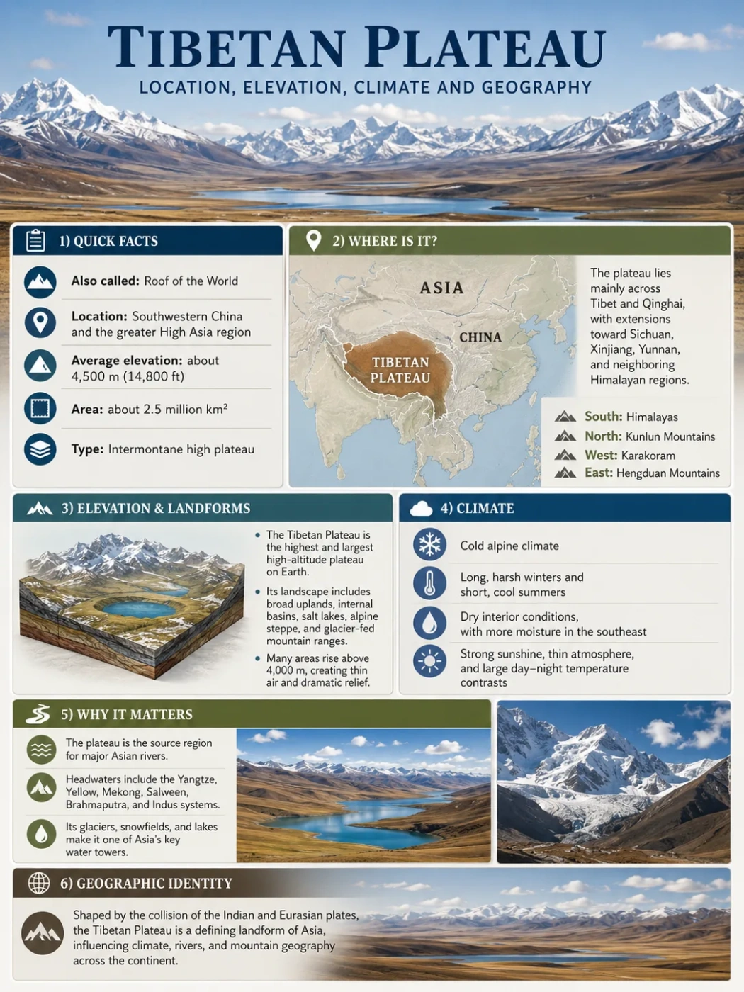
The Tibetan Plateau is a vast, high landform in the heart of Asia. It sits between major mountain systems, rises to an average elevation of about 4,500 meters, and helps shape climate, rivers, glaciers, grasslands and settlement across a wide part of the continent.
The Tibetan Plateau, also called the Qinghai-Tibet Plateau or Plateau of Tibet, is often described as the highest and largest plateau on Earth. It is not a flat tabletop. It is a broad highland made of upland basins, mountain ranges, grasslands, lakes, river valleys, glaciers and dry interior plains.
Its geography matters because it sits at the meeting point of several major landform systems: the Himalayas, Karakoram, Kunlun Mountains, Qilian Mountains, Hengduan Mountains and the high basins of western China. This makes the plateau one of the clearest examples of how tectonic uplift, elevation and climate work together.
| Feature | Tibetan Plateau Profile |
|---|---|
| Name | Tibetan Plateau, Qinghai-Tibet Plateau, Plateau of Tibet |
| Location | Central and southwestern Asia, mainly across Tibet Autonomous Region and Qinghai, with extensions toward western Sichuan, southern Xinjiang and nearby high mountain margins |
| Approximate Area | Roughly 2.5 million square kilometers |
| Approximate Elevation | Often described as averaging about 4,500 meters above sea level; many areas lie between about 4,000 and 5,000 meters |
| Landform Type | High tectonic plateau, intermontane upland and mountain-basin system |
| Main Mountain Borders | Himalayas to the south, Karakoram to the southwest, Kunlun Mountains to the north, Qilian Mountains to the northeast and Hengduan Mountains to the east |
| Climate Pattern | Cold, dry and high-altitude overall, with stronger monsoon influence toward the south and east |
| Known For | High elevation, glacier-fed rivers, inland lakes, grasslands, mountain ranges and influence on Asian climate systems |
Elevation Note
The plateau’s elevation is usually given as an average. Local heights vary a lot because the region includes basins, valleys, lake floors, mountain ranges and peaks. A map may show “Tibetan Plateau” as one landform, but the ground is far from uniform.
Where Is the Tibetan Plateau Located?
The Tibetan Plateau lies in the interior of Asia, north of the Himalayas and south of the Kunlun Mountains. Its core area covers the Tibet Autonomous Region and much of Qinghai. Depending on how the boundary is drawn, it also reaches toward western Sichuan, southern Xinjiang, parts of Gansu and the high mountain margins near the Himalaya and Karakoram systems.
On a physical map, the plateau appears as a raised block between some of Asia’s strongest topographic edges. The Himalayas form a sharp southern rim. The Kunlun Mountains mark much of the northern edge. To the east, the land breaks into the complex folds and deep river valleys of the Hengduan Mountains.
Map Note
To find the Tibetan Plateau on a map, look north of India, Nepal and Bhutan, then follow the high ground across Tibet and Qinghai. The plateau is easier to recognize on a relief map than on a political map because its true outline follows elevation, basins and mountain belts rather than country borders.
Main Geographic Edges
Southern Edge
Himalayas
The Himalayas form the steep southern wall of the plateau. This edge includes some of the highest mountains on Earth and strongly affects moisture movement from the south.
Northern Edge
Kunlun Mountains
The Kunlun system separates much of the plateau from the dry basins and deserts farther north. It is one of the main boundaries used in physical geography descriptions.
Eastern Edge
Hengduan Mountains
The eastern margin is not a clean step down. It breaks into parallel mountain ridges and deep river valleys where the plateau grades into southwestern China’s rugged highlands.
Interior
Basins, Lakes and Grasslands
The interior contains high basins, brackish lakes, cold grasslands and wide open uplands. The Qiangtang area in the north is especially known for remote high plateau terrain.
How High Is the Tibetan Plateau?
The Tibetan Plateau is commonly described as averaging about 4,500 meters above sea level. Many large areas sit between about 4,000 and 5,000 meters. That makes it much higher than most famous plateaus, including the Deccan Plateau in India, the Colorado Plateau in the United States and the Brazilian Highlands in South America.
This high elevation is the reason the plateau is often called the “Roof of the World.” The phrase is useful as a simple image, but it can be misleading if it suggests a smooth roof. The plateau is better understood as a broad, raised highland system with mountain chains, internal basins and river corridors.
Measurement Note
Area and elevation figures can vary by source because geographers do not always draw the plateau boundary in exactly the same way. Some descriptions focus on the core Qinghai-Tibet Plateau, while others include wider mountain margins and connected highlands.
Why the Elevation Feels So Different on the Ground
Elevation changes the way a landscape works. On the Tibetan Plateau, thinner air, lower temperatures, strong sunlight, wind exposure and shorter growing seasons all affect soil, vegetation, water, animals and settlement patterns.
- Temperature drops with height: even sunny areas can remain cool because the land sits so far above sea level.
- Water behaves differently: snow, ice, frozen ground, seasonal meltwater and highland lakes all play major roles.
- Vegetation is limited by cold and dryness: grassland, alpine meadow and shrubland are more common than dense forest across much of the plateau.
- Human settlement follows valleys and usable land: towns, farms and transport routes often concentrate where water, slope and soil allow easier living.
How the Tibetan Plateau Formed
The Tibetan Plateau formed mainly through the long collision between the Indian Plate and the Eurasian Plate. This collision began tens of millions of years ago and continues to affect the region today. The land was squeezed, shortened, thickened and lifted, while faults and mountain belts helped shape its margins.
The process did not create the plateau in one simple step. Different parts rose and changed at different times. Some areas were affected by crustal shortening, some by strike-slip faulting, some by extension, and others by erosion and river cutting after uplift.
Continental Plates Converge
The Indian Plate moved northward toward Eurasia. Instead of sliding easily under ocean crust, the continental crust resisted and compressed.
Crust Thickens and Rises
As the land was squeezed, the crust thickened. This helped raise a broad region rather than forming only a narrow mountain chain.
Mountain Ranges Define the Edges
The Himalayas, Kunlun, Qilian and other ranges developed as parts of the wider uplifted system. They frame the plateau and control many drainage paths.
Rivers and Basins Rework the Surface
After uplift, rivers cut valleys, glaciers shaped high areas, and internal basins collected lakes and sediment. The plateau surface became varied, not flat.
Landform Note
The Tibetan Plateau is mainly a tectonic plateau, but it also contains many smaller landforms inside it: intermontane basins, glacial valleys, lake basins, alluvial plains, escarpments and dissected river valleys.
Why It Is Not Just a Mountain Range
A mountain range usually refers to a long belt of peaks and ridges. A plateau is a broad elevated landform with a large surface area. The Tibetan Plateau includes mountains, but the key point is the scale of the raised highland behind and between them.
Tibetan Plateau
- Broad highland system
- Large areas above 4,000 meters
- Contains basins, lakes, grasslands and mountain belts
- Formed through long tectonic uplift and crustal thickening
Himalayas
- Major mountain range along the southern edge
- Includes very high peaks and steep relief
- Acts as a climatic and topographic barrier
- Closely linked to the same plate collision system
Climate of the Tibetan Plateau
The climate of the Tibetan Plateau is shaped by elevation, distance from oceans, mountain barriers and seasonal wind patterns. Much of the plateau is cold and dry, especially in the north and interior. The south and east receive more moisture because they are closer to monsoon-influenced regions.
High elevation keeps temperatures lower than nearby lowlands at the same latitude. Winters can be severe, while summers are short and often cool. Day-night temperature differences can be large because the air is thin and dry.
| Climate Factor | How It Affects the Plateau |
|---|---|
| High Elevation | Creates cooler conditions, thinner air, stronger sunlight and shorter growing seasons |
| Mountain Barriers | The Himalayas reduce the movement of moist air into many interior areas |
| Monsoon Influence | Southern and eastern areas can receive more seasonal rain than the dry interior |
| Continental Interior Position | Large distance from oceans helps create dry, cold and windy conditions in many areas |
| Glaciers and Snow | Store water at high elevation and feed rivers during melt seasons |
Main Landscape Zones
The plateau’s landscapes change from one region to another. The northern interior is often colder and drier, with broad grasslands, steppe-like areas and many lakes. The south includes river valleys and agricultural pockets. The east is more dissected, with deep valleys, forested slopes in some areas and stronger moisture influence.
- Alpine grassland: common across large high areas where cold and grazing shape vegetation.
- Alpine meadow: found where moisture is better and growing conditions allow denser plant cover.
- Cold desert and steppe: more common in dry interior basins and northern areas.
- Valley farmland: found in selected river valleys where soil, water and temperature are more favorable.
- Glacial and lake landscapes: found near high mountains, closed basins and snow-fed drainage systems.
Field Note
Climate on the plateau should not be described with one label only. A cold, dry interior basin and a wetter eastern mountain valley can both belong to the Tibetan Plateau, yet feel very different on the ground.
Rivers, Lakes and Basins
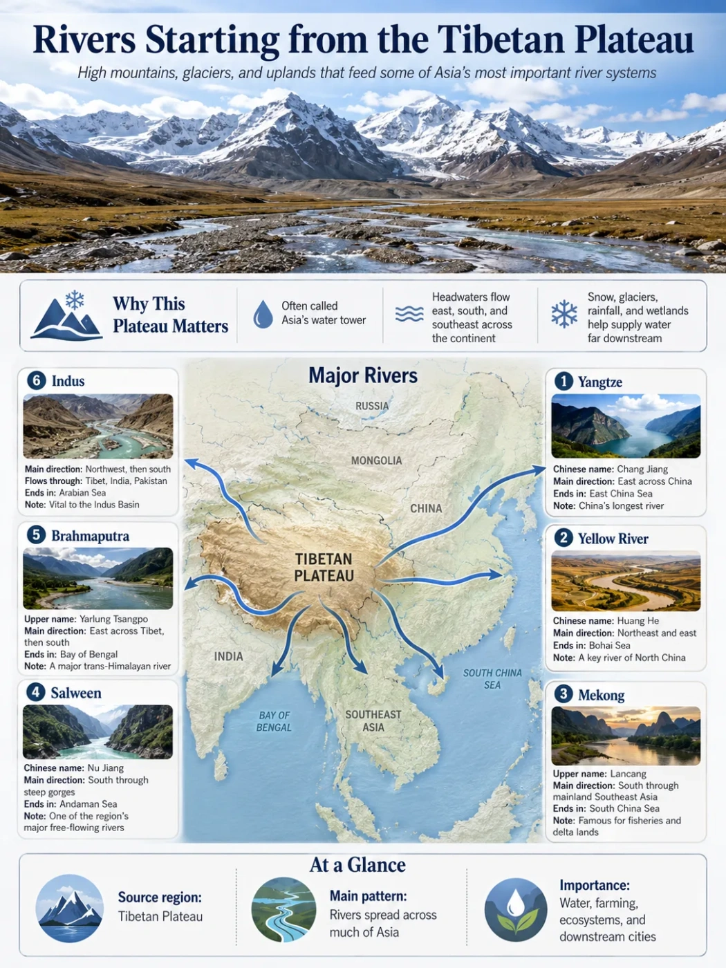
The Tibetan Plateau is one of Asia’s great water source regions. Many major rivers begin on or near the plateau and then flow into lower lands across South, Southeast and East Asia. Snow, glacier melt, rainfall, groundwater and lake systems all help feed these river networks.
Important rivers connected with the plateau include the Yarlung Tsangpo-Brahmaputra, Indus, Yangtze, Yellow River, Mekong and Salween. Some descriptions also connect the wider Himalayan-plateau water system with headwaters that feed the Ganges basin.
| River or Basin | Geographic Role |
|---|---|
| Yarlung Tsangpo / Brahmaputra | Flows across southern Tibet before turning through deep Himalayan terrain and continuing toward South Asia |
| Indus | Linked to the western plateau and trans-Himalayan highlands before flowing toward South Asia |
| Yangtze / Chang Jiang | Has headwater areas on the eastern plateau and becomes one of East Asia’s major river systems |
| Yellow River / Huang He | Begins in the highlands of Qinghai and drains toward northern China |
| Mekong / Lancang | Rises in the plateau region and flows through deep valleys toward Southeast Asia |
| Salween / Nu Jiang | Begins in the highlands and cuts through rugged eastern plateau margins |
| Interior Lake Basins | Many lakes sit in closed basins, especially in northern and central plateau areas where water may not drain to the sea |
Why the Plateau Has So Many Lakes
Many parts of the plateau contain closed basins. In a closed basin, water flows into a lake or low area but does not reach the ocean through a river. Over time, evaporation, mineral concentration, snowmelt and changing climate conditions can create brackish or saline lakes.
This is why the plateau is dotted with lakes of different sizes, colors and water chemistry. Some are fed by glaciers. Some are seasonal. Some sit in dry interior basins where evaporation is strong.
Water Source
Glaciers and Snowfields
High mountains store water as snow and ice. Meltwater helps feed rivers and lakes during warmer seasons.
Drainage Pattern
Open and Closed Basins
Some rivers leave the plateau and flow across Asia. Other basins trap water in lakes without a direct path to the sea.
River Shape
Deep Valleys and Braided Channels
Where rivers cut through uplifted terrain, they can form deep valleys. In flatter high valleys, sediment-rich channels may braid across wide river beds.
Geography by Region
The Tibetan Plateau is too large to read as one simple surface. It is better understood through broad geographic zones. These zones are not strict political divisions; they describe how elevation, climate, drainage and landforms change across the plateau.
| Plateau Zone | Main Features | Geographic Importance |
|---|---|---|
| Northern Plateau / Qiangtang | High, cold, dry interior with grasslands, lakes and broad basins | Shows the plateau’s remote interior character and closed-basin landscapes |
| Southern Plateau | River valleys, Himalayan edge, agricultural pockets and major settlements such as Lhasa | Connects the plateau to the Himalayas and the Yarlung Tsangpo-Brahmaputra system |
| Eastern Plateau Margin | Deep valleys, folded ranges and stronger moisture influence | Acts as a transition between the high plateau and the mountains of southwestern China |
| Northeastern Plateau | Qinghai highlands, headwater regions, grasslands and mountain-basin systems | Includes important source areas for the Yellow River and Yangtze headwaters |
| Western Plateau Margin | High, dry terrain near the Karakoram, Trans-Himalayan and interior Asian mountain systems | Links the plateau with some of Asia’s most rugged high mountain landscapes |
Common Mix-Up
The Tibetan Plateau is not the same as Tibet as a cultural or administrative term. The plateau is a physical landform. Its boundaries follow high terrain, mountain systems and basins, while political and cultural regions are defined in different ways.
Why the Tibetan Plateau Matters in Geography
The Tibetan Plateau is important because it connects landform formation, climate, rivers and human geography at a continental scale. Few places show the relationship between high elevation and regional climate so clearly.
It Shapes Atmospheric Patterns
A broad high surface heats and cools differently from lowlands. The plateau can influence wind patterns, pressure systems and the seasonal movement of moisture across Asia. Its relationship with the monsoon is complex, but its height and size make it a major part of Asian climate geography.
It Feeds Major River Systems
The plateau and its surrounding mountains hold snow, glaciers, wetlands, lakes and headwater streams. These features help support rivers that flow far beyond the plateau itself.
It Creates Strong Ecological Zones
Cold grasslands, alpine meadows, lake basins, dry steppe, glacial zones and forested valleys can all appear within the wider plateau system. Elevation and moisture decide where each landscape type can survive.
It Shows Active Earth Processes
The region is still shaped by tectonic movement, faulting, erosion, river incision, glacial processes and sediment movement. It is not a frozen ancient surface. It is a living landform system that continues to change over long periods.
Based on its commonly cited average elevation of about 4,500 meters.
Several major Asian river systems begin on or near the plateau.
The plateau includes basins, ranges, lakes, valleys, glaciers and grasslands rather than one flat surface.
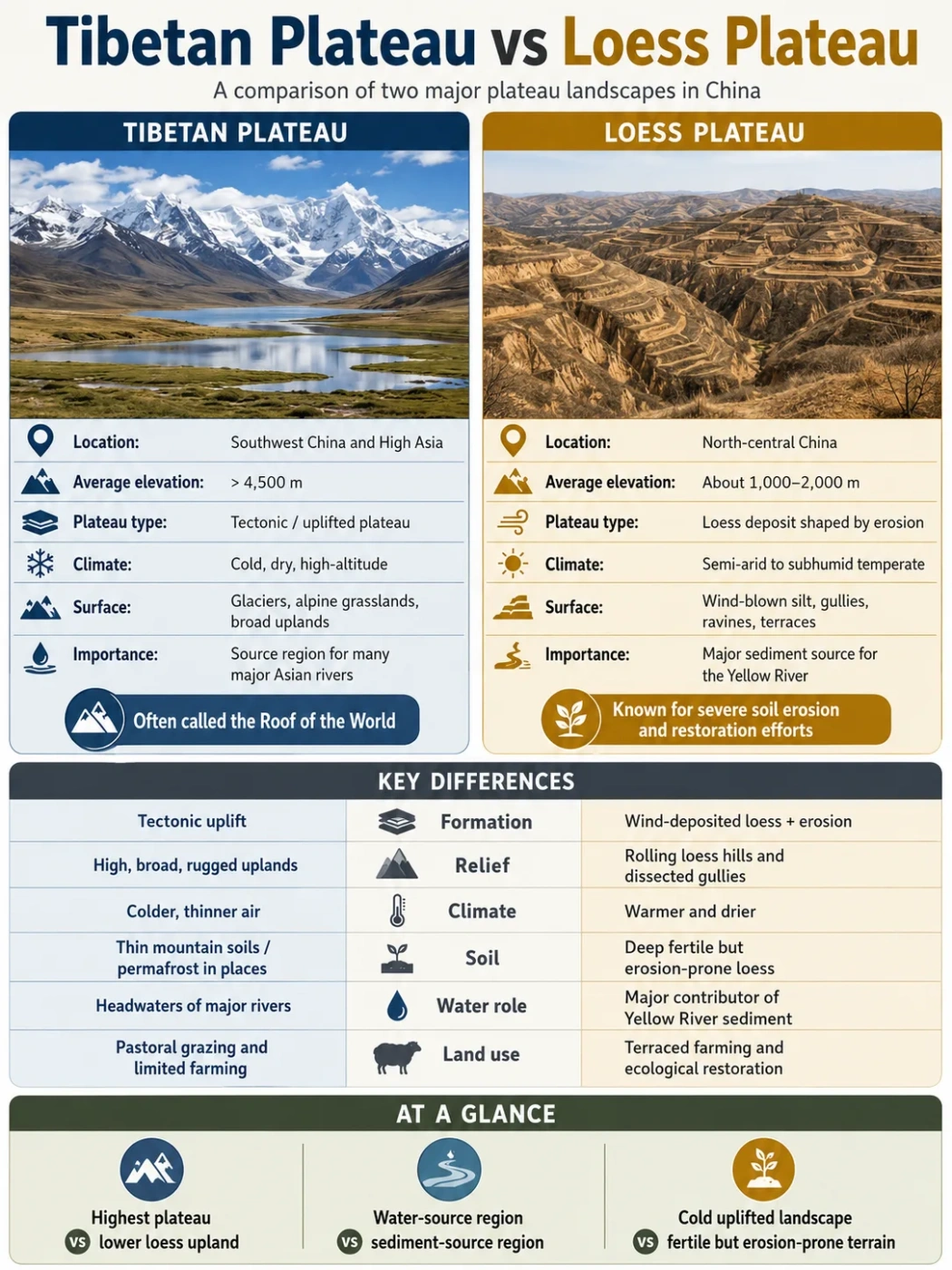
Tibetan Plateau Compared With Other Plateaus
The Tibetan Plateau stands apart because of its mix of height, size and tectonic setting. Many plateaus are high, and many are large, but few combine such great elevation with such broad area.
| Plateau | General Location | Main Difference From the Tibetan Plateau |
|---|---|---|
| Tibetan Plateau | Central and southwestern Asia | Much higher and broader than most plateaus, formed by major continental collision |
| Deccan Plateau | Peninsular India | Lower in elevation and strongly linked with ancient volcanic rocks and erosion |
| Colorado Plateau | Southwestern United States | Known for layered sedimentary rocks, canyons and erosion rather than extreme average elevation |
| Altiplano | Central Andes, South America | Also very high, but smaller and set within the Andean mountain system |
| Iranian Plateau | Southwest and Central Asia | A large upland region, but generally lower and more basin-desert dominated |
Simple Rule for Reading It on a Map
If a map shows a wide high area north of the Himalayas, framed by major mountain belts and crossed by high river sources, it is likely showing the Tibetan Plateau. If the map only shows a narrow line of peaks, it is showing a mountain range, not the full plateau.
Common Mix-Up
The Himalayas are the southern mountain edge. The Tibetan Plateau is the broad highland behind that edge. They are closely related, but they are not the same landform.
Useful Terms for Understanding the Tibetan Plateau
Plateau
A broad elevated landform. In this case, the plateau is high, large and shaped mainly by tectonic uplift.
Highland
A general term for elevated land. The Tibetan Plateau is a highland, but it is more specific because it is a large plateau system.
Intermontane Plateau
A plateau located among or between mountain ranges. The Tibetan Plateau fits this idea because it sits between major Asian mountain systems.
Uplift
The raising of land by tectonic forces. Uplift is central to the plateau’s formation.
Basin
A lower area that collects water or sediment. The plateau contains many internal basins and lake basins.
Escarpment
A steep slope or edge between higher and lower land. Some plateau margins and river-cut areas can form sharp escarpment-like terrain.
FAQ
Where is the Tibetan Plateau located?
The Tibetan Plateau is located in central and southwestern Asia, mainly across Tibet Autonomous Region and Qinghai, with extensions toward western Sichuan, southern Xinjiang and nearby high mountain margins. It lies north of the Himalayas and south of the Kunlun Mountains.
How high is the Tibetan Plateau?
It is commonly described as averaging about 4,500 meters above sea level. Many areas lie between about 4,000 and 5,000 meters, although local elevations vary because the plateau includes basins, valleys, mountains and lake floors.
Why is the Tibetan Plateau called the Roof of the World?
It gets this nickname because it is one of Earth’s highest and broadest elevated regions. The phrase is simple and memorable, but the plateau is not flat like a roof. It includes mountains, basins, grasslands, lakes, glaciers and deep valleys.
How did the Tibetan Plateau form?
It formed mainly through the long collision between the Indian Plate and the Eurasian Plate. This collision thickened and uplifted the crust, while faulting, mountain building, river cutting and erosion shaped the surface over time.
Is the Tibetan Plateau the same as the Himalayas?
No. The Himalayas are a major mountain range along the southern edge of the plateau. The Tibetan Plateau is the much broader highland system north of that range. They are closely linked by the same tectonic collision, but they are different landforms.
What rivers begin on or near the Tibetan Plateau?
Major river systems connected with the plateau include the Yarlung Tsangpo-Brahmaputra, Indus, Yangtze, Yellow River, Mekong and Salween. The wider Himalayan-plateau water system also connects with important South Asian drainage basins.
What is the climate like on the Tibetan Plateau?
The climate is generally cold, dry and high-altitude, especially in the interior and north. Southern and eastern areas can receive more seasonal moisture. Elevation, mountain barriers and monsoon influence create strong regional differences.
Why is the Tibetan Plateau important in geography?
It is important because it affects climate patterns, feeds major rivers, supports high-altitude ecosystems and shows how tectonic uplift can create a vast plateau. It also helps explain the relationship between mountains, basins, rivers and climate in Asia.