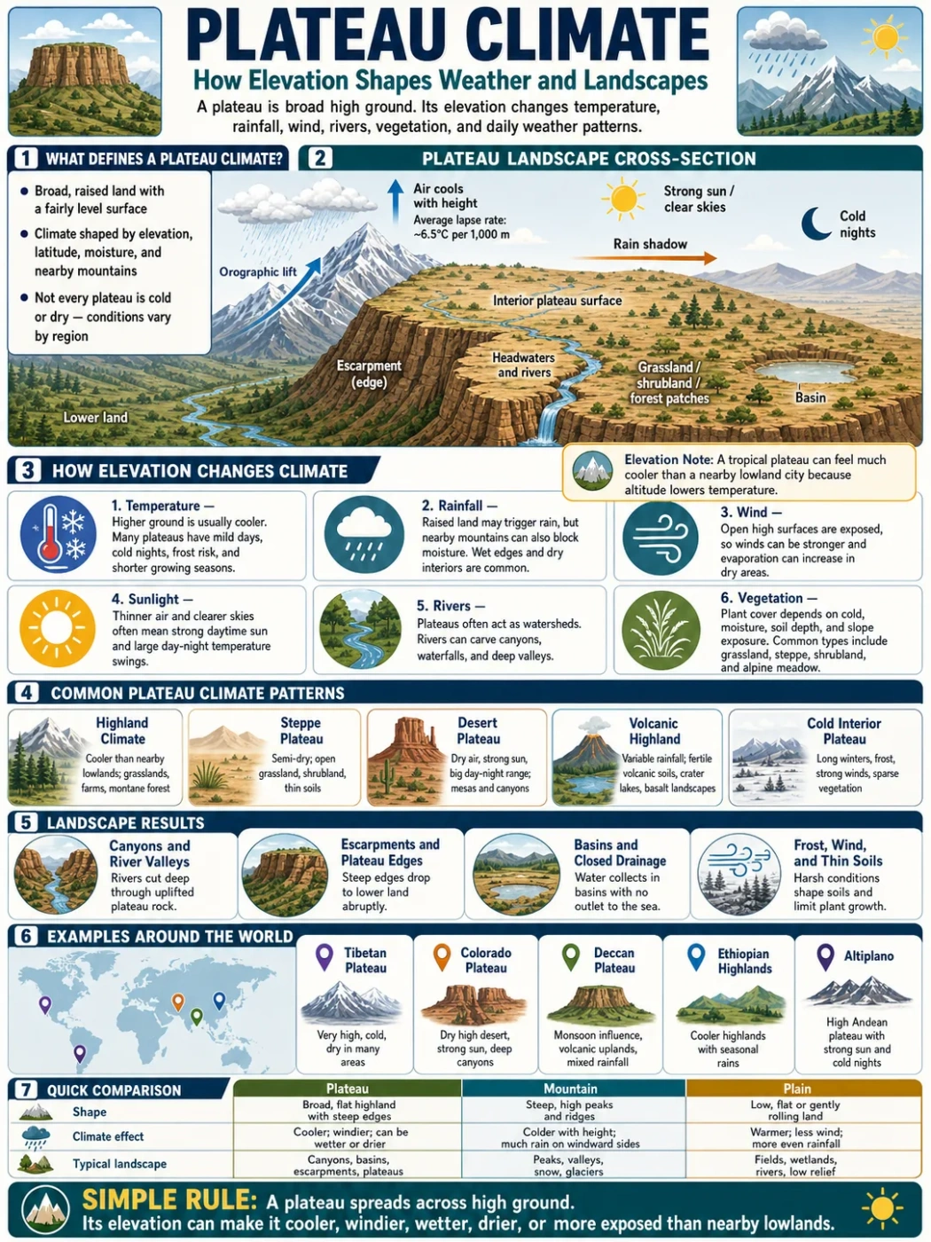
A plateau climate is shaped first by elevation. A plateau may sit in the tropics, a desert belt, a temperate zone, or near high mountains, but its raised surface changes temperature, rainfall, wind, vegetation, rivers, and even daily life. In simple terms, a plateau is high ground with a broad, fairly level surface, and that height often makes its climate different from the lowlands around it.
Not every plateau is cold. Not every plateau is dry. The climate depends on height, latitude, nearby mountains, distance from the sea, wind direction, and whether the plateau is cut by rivers, basins, escarpments, or volcanic highlands.
| Climate Feature | How Elevation Affects It | Common Plateau Result |
|---|---|---|
| Temperature | Air usually cools with height, often by about 6.5°C per 1,000 m in the lower atmosphere. | Cooler summers, cold nights, frost risk, and shorter growing seasons. |
| Rainfall | Raised land can force moist air upward, while nearby mountains can block rain. | Wet windward slopes, dry interiors, or rain-shadow basins. |
| Wind | Open high surfaces have fewer barriers and stronger exposure. | Windy grasslands, thin soils, and high evaporation in dry regions. |
| Sunlight | Higher ground often has thinner air and clearer skies. | Strong daytime sun, sharp night cooling, and larger daily temperature swings. |
| Rivers | Plateaus often act as watersheds or headwater zones. | Canyons, waterfalls, deeply cut valleys, and river basins starting on high ground. |
| Vegetation | Cooler air, frost, slope exposure, and soil depth limit plant growth. | Grassland, steppe, alpine meadow, shrubland, forest patches, or dry plateau scrub. |
Elevation Note: A plateau can share the same latitude as a hot lowland city but feel much cooler because it sits higher. This is why some tropical plateaus have mild highland climates rather than hot lowland climates.
What Plateau Climate Means
Plateau climate is not one single climate type. It is the climate pattern created when a broad highland surface changes normal weather conditions. The raised landform affects air temperature, cloud formation, drainage, wind flow, and the way landscapes store or lose moisture.
Some plateaus are cool and grassy. Some are volcanic and fertile. Some are dry, stony tablelands. Others hold lakes, wetlands, forests, farms, or high-altitude cities.
The best way to understand a plateau climate is to ask three questions:
- How high is the plateau above sea level?
- What surrounds it: ocean, mountains, desert, plains, or basins?
- Where does the moisture come from, and what blocks it?
Those answers explain why the Tibetan Plateau is cold and dry in many areas, why the Ethiopian Highlands receive seasonal rains, and why the Colorado Plateau has dry canyons, strong sun, and sharp temperature shifts.
Why Higher Plateaus Are Usually Cooler
Temperature often falls as elevation rises. This is because air pressure decreases with height, and rising air expands and cools. The average environmental lapse rate is often described as about 6.5°C per 1,000 meters, although real conditions can vary by season, humidity, and local weather.
That cooling effect shapes the basic feel of many plateaus. A town on a high plateau may have warm afternoons but cold nights. Frost can appear even where the surrounding lowlands stay mild.
Daily Temperature Range on Plateaus
Plateaus often have a wide daily temperature range. The surface heats under strong sunlight during the day, then loses heat fast after sunset. Dry air makes this effect stronger because water vapor normally helps hold heat near the ground.
This is common in dry highlands and interior plateaus. A plateau basin may feel hot at midday, then cool sharply by night.
Why Latitude Still Matters
Elevation does not erase latitude. A high plateau near the equator may be mild rather than freezing. A high plateau in a cold continental interior may face long winters, snow, and frozen ground.
So, height changes the climate, but latitude sets the broad background.
How Plateaus Shape Rainfall
Plateaus can help form rain, block rain, or sit in dry zones where little moisture arrives. This is why rainfall patterns on highlands are often uneven.
Orographic Lift
When moist air meets a plateau edge, escarpment, or mountain barrier, it may rise. As the air rises, it cools. Cooler air can hold less water vapor, so clouds and rain may form.
This process is called orographic lift. It helps explain why some plateau margins are wetter than nearby lowlands.
Rain Shadow Effects
A plateau may also lie behind mountains that remove moisture from the air before it reaches the interior. The dry side is called a rain shadow.
Rain-shadow plateaus often have steppe, scrubland, salt flats, or desert basins. The interior of the Tibetan Plateau and parts of the Colorado Plateau show this pattern in different ways.
Seasonal Rainfall
Some plateaus receive most of their rain during a clear wet season. Tropical and subtropical highlands often depend on seasonal wind shifts. The Ethiopian Highlands, for example, have areas where summer rains feed major river systems and support highland farming.
Geography Note: A plateau edge can be wetter than the plateau interior. On a map, look for escarpments, nearby mountain chains, and rivers that start near the raised margin.
Common Climate Types Found on Plateaus
Because plateaus occur across many regions, they can have several climate types. The same landform shape can appear under very different weather patterns.
| Plateau Climate Pattern | Typical Conditions | Landscape Clues | Example Regions |
|---|---|---|---|
| Highland Climate | Cooler than nearby lowlands, with strong elevation effects. | Terraced farms, grasslands, montane forests, cold nights. | East African Highlands, Andean plateaus, Mexican Plateau. |
| Steppe Plateau | Semi-dry, with limited rain and open vegetation. | Grassland, shrubland, thin soils, seasonal streams. | Parts of Central Asia, Anatolian Plateau, interior highlands. |
| Desert Plateau | Dry air, strong sun, large day-night temperature range. | Canyons, mesas, badlands, salt flats, bare rock. | Colorado Plateau, Iranian Plateau margins, parts of Arabia. |
| Volcanic Highland | Varies by height and rainfall, often with fertile volcanic soils. | Basalt plains, volcanic cones, highland farms, crater lakes. | Deccan Plateau, Ethiopian Highlands, parts of East Africa. |
| Cold Interior Plateau | Long winters, strong winds, frost, and low humidity. | Alpine meadow, dry valleys, sparse vegetation, frozen lakes in winter. | Tibetan Plateau, Pamir region, high Central Asian basins. |
How Plateau Climate Shapes Landscapes
Climate does not only affect weather. It also shapes the surface of the plateau. Temperature, rain, frost, wind, and river flow all help form the landscape over time.
Canyons and River Valleys
Many plateaus are cut by rivers. When a river flows across raised land, it can carve deep valleys and canyons, especially if uplift has raised the surface while the river keeps cutting downward.
The Colorado Plateau is well known for this pattern. Its dry climate limits thick vegetation in many areas, so rock layers, cliffs, mesas, and canyons are easy to see.
Escarpments and Plateau Edges
An escarpment is a steep slope or cliff-like edge where the plateau drops toward lower land. Escarpments can change wind, rainfall, settlement routes, and river direction.
Wet air may rise along an escarpment and bring rain to the edge. Behind it, the plateau interior may be drier.
Basins and Closed Drainage
Some plateaus contain basins where water does not reach the sea. Streams may end in lakes, wetlands, salt flats, or dry lake beds. These are called closed basins or endorheic basins.
Dry plateau basins often collect salts because water evaporates and leaves minerals behind.
Frost, Wind, and Thin Soils
On high plateaus, frost can break rock apart. Wind can remove loose material. Thin soils may form where cold, dryness, or steep slopes slow plant growth.
This is why many high plateaus look open and exposed, even where they are not true deserts.
Plateau Climate and Rivers
Plateaus often act as water towers for surrounding regions. Their height helps collect snow, rain, or seasonal runoff. Rivers may begin on the plateau, cut across it, or drain from its edges into lower basins.
Some of the world’s well-known river systems are linked with highlands and plateaus. The Tibetan Plateau is connected with major Asian river headwaters. The Ethiopian Highlands feed the Blue Nile system. The Deccan Plateau is crossed by rivers such as the Godavari, Krishna, and Narmada.
River patterns on plateaus depend on slope, rock type, rainfall, and tectonic history. A basalt plateau may have broad river valleys and waterfalls. A dry sedimentary plateau may have canyons and seasonal streams.
Plateau Climate and Human Life
People live on many plateaus, but climate affects how land is used. Elevation, rainfall, frost risk, and soil type shape farming, settlement, roads, and water use.
Farming on Plateaus
Cooler temperatures can help some crops but limit others. On tropical plateaus, elevation may create mild growing conditions. In cold or dry plateaus, the growing season may be short, and irrigation may matter more.
Volcanic plateaus can have fertile soils, but fertility alone does not solve every problem. Water supply, slope, erosion, and frost still matter.
Settlements and Cities
Some plateau cities sit high above sea level and have milder climates than nearby lowlands. Mexico City, Addis Ababa, and Bogotá are examples of major highland cities, though each has its own local setting.
High elevation can bring cooler air, but it can also bring thinner air, stronger sun, and colder nights.
Travel and Map Reading
On a physical map, plateau climates often show up through landform clues:
- Wide high areas with contour lines around the edge.
- Rivers cutting deep channels through raised ground.
- Escarpments marking sharp changes in elevation.
- Dry basins, salt lakes, or seasonal streams in interior zones.
- Vegetation changes between lowlands and highlands.
Map Note: A plateau is not identified by height alone. Look for a raised surface with broad, flatter terrain compared with surrounding slopes, mountains, valleys, or plains.
Examples of Plateau Climate Around the World
Plateaus show how the same landform category can hold very different climates. These examples show the range.
Tibetan Plateau
The Tibetan Plateau is often described as the highest and largest plateau region on Earth. Much of it sits above 4,000 meters. Its climate is shaped by extreme elevation, interior location, strong sun, cold nights, mountain barriers, and large seasonal changes.
Many areas are cold and dry, with alpine grassland, steppe, lakes, and permafrost in some zones.
Colorado Plateau
The Colorado Plateau in the southwestern United States is known for high desert landscapes, canyons, mesas, cliffs, and exposed rock layers. Elevation varies widely, but many areas sit roughly between 1,500 and 3,000 meters.
The climate is often dry, with strong sun, cold winter nights in higher areas, and river erosion that has carved deep canyons.
Deccan Plateau
The Deccan Plateau covers much of peninsular India. It is a large upland region with old volcanic rocks in many areas, especially the Deccan Traps. Its climate changes across the plateau because of monsoon rainfall, elevation, distance from coasts, and the Western and Eastern Ghats.
Some areas are semi-dry, while others support farming, rivers, and broad basalt landscapes.
Ethiopian Highlands
The Ethiopian Highlands form a raised volcanic region in East Africa. Elevation creates cooler conditions than nearby lowlands, while seasonal rains feed rivers, farms, and deeply cut valleys.
The highlands are closely linked with the Blue Nile system and show how plateau climate can support dense settlement in some areas.
Altiplano
The Altiplano is a high plateau in the central Andes, mainly linked with Bolivia and Peru, with parts extending toward nearby countries. Much of it sits at very high elevation, often above 3,500 meters.
Its climate is cool for its latitude, with strong sun, cold nights, dry zones, salt flats, lakes, and mountain borders.
Plateau Climate vs Mountain Climate
A plateau and a mountain can both be high, but they do not shape climate in the same way. The difference is mainly in surface form.
| Feature | Plateau Climate | Mountain Climate |
|---|---|---|
| Landform Shape | Broad raised surface, often with flatter interior areas. | Steep slopes, peaks, ridges, and strong vertical changes. |
| Temperature Pattern | Cooler than nearby lowlands, with wide open-surface effects. | Changes sharply with altitude and slope direction. |
| Rainfall Pattern | Edges may be wetter, interiors may be dry or basin-like. | Windward slopes often wetter, leeward slopes drier. |
| Rivers | May act as a headwater zone or be cut by deep valleys. | Streams often begin on steep slopes and flow quickly downhill. |
| Landscape Clue | Tablelands, basins, escarpments, canyons, grasslands. | Peaks, passes, glaciers in cold zones, sharp ridgelines. |
A simple rule helps: a mountain rises to a peak, while a plateau spreads across high ground.
Plateau Climate vs Plain Climate
A plain is usually lower and flatter than a plateau. A plateau may also look flat in places, but it sits higher and often has steep edges, river-cut valleys, or nearby escarpments.
This height changes the climate. A plateau may be cooler, windier, drier, or more exposed than a nearby plain. It may also collect snow or seasonal rainfall that feeds rivers below.
Plains often have deeper soils and wider lowland river systems. Plateaus often have thinner soils, exposed rock, sharper drainage, and stronger elevation effects.
Common Misconceptions About Plateau Climate
All Plateaus Are Cold
This is not true. Low and mid-elevation plateaus in warm regions can be hot, especially in dry zones. Higher elevation usually cools the air, but latitude and moisture still matter.
All Plateaus Are Deserts
Many dry plateaus exist, but plateaus can also have forests, farms, wetlands, lakes, and grasslands. The Deccan Plateau, Ethiopian Highlands, and parts of East African highlands show that plateaus can support varied landscapes.
A Plateau Climate Is Always the Same Across the Whole Plateau
Large plateaus contain local climates. Edges, basins, valleys, slopes, volcanic areas, and river corridors may differ from one another. A single plateau can include dry interiors, wetter margins, cold uplands, and warmer lower valleys.
Terms Often Connected with Plateau Climate
| Term | Meaning | Why It Matters for Plateaus |
|---|---|---|
| Elevation | Height above sea level. | Controls cooling, frost risk, air pressure, and many vegetation patterns. |
| Highland | A broad raised region, often with hills, plateaus, or mountains. | Many plateaus are part of wider highland systems. |
| Escarpment | A steep slope or sharp landform edge. | Marks plateau margins and can affect rainfall and drainage. |
| Basin | A low or enclosed area where water and sediment collect. | Plateaus may contain dry basins, lakes, or internal drainage zones. |
| Rain Shadow | A dry area behind a mountain or high barrier. | Explains why some plateau interiors are dry. |
| Orographic Lift | Air rising over high land, cooling, and forming clouds or rain. | Explains wetter plateau edges and mountain-facing slopes. |
| Tableland | A flat or gently rolling raised land surface. | Often used for plateau-like landscapes with broad level tops. |
Mini FAQ
What is a plateau climate?
A plateau climate is the weather pattern found on raised, broad land surfaces. It is shaped by elevation, wind, rainfall, latitude, nearby mountains, and the way rivers and basins cut across the plateau.
Are plateaus always colder than nearby lowlands?
Plateaus are often cooler than nearby lowlands because temperature usually drops with elevation. The amount of cooling depends on height, humidity, season, and local weather.
Why are some plateaus dry?
Some plateaus are dry because they sit far from oceans, lie behind mountain rain shadows, or have strong evaporation under clear skies and wind. Interior basins on plateaus can be especially dry.
Can a plateau have forests?
Yes. Plateaus can have forests if rainfall, soil, and temperature support tree growth. Some plateau areas have montane forests, while drier or colder parts may have grassland, shrubland, or bare rock.
How does elevation affect farming on plateaus?
Elevation can make plateau farming cooler and limit the growing season. It can also reduce heat stress in tropical regions. Water supply, frost risk, slope, and soil type decide what crops can grow.
Is a plateau the same as a mountain?
No. A mountain rises toward peaks and steep slopes, while a plateau is a broad raised surface. Both can be high, but their shapes and climate patterns are not the same.