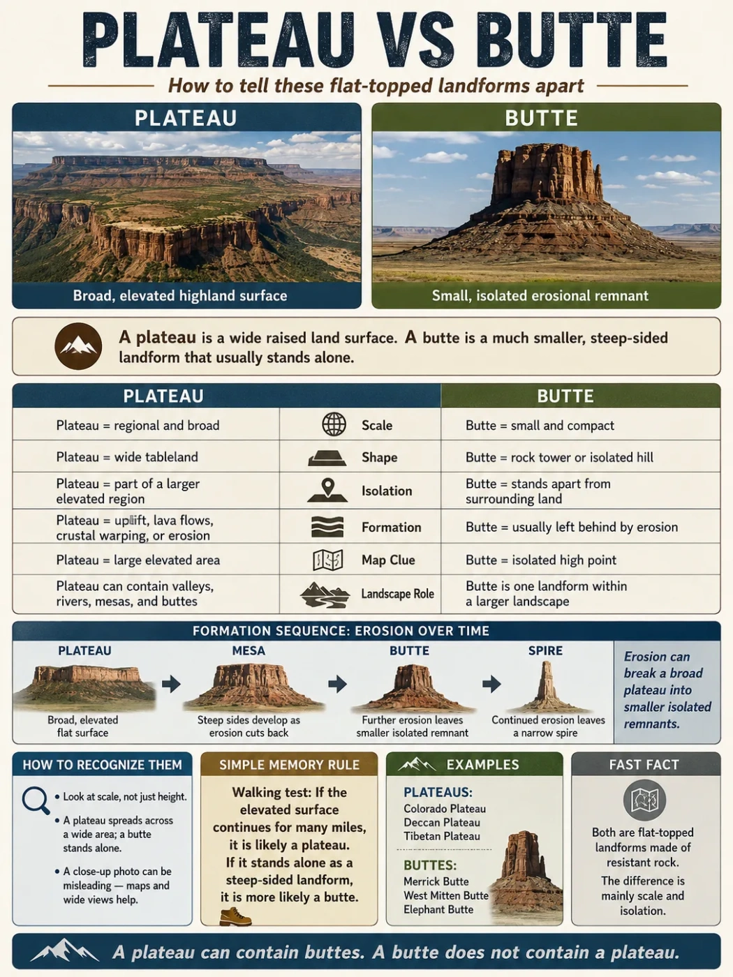
A plateau and a butte can both rise above surrounding land and may both have relatively flat upper surfaces, but they are not the same kind of feature at different elevations. A plateau is a broad elevated land surface that can extend across a large region, while a butte is a much smaller, isolated landform with steep sides and a restricted summit. The difference is mainly about scale, continuity, isolation and landscape form rather than one fixed height or size threshold.
The Difference Is Scale, Continuity and Isolation
The simplest distinction is not “high versus low” or even “large versus small.” A plateau forms part of the larger structure of a landscape. A butte is a discrete feature that stands apart from the terrain around it.
A plateau may continue for many kilometers and can contain valleys, rivers, canyons, hills and other landforms across its upper surface. A butte normally appears as one recognizable prominence surrounded by lower ground.
| Characteristic | Plateau | Butte |
|---|---|---|
| Landscape scale | Broad regional or subregional land surface | Localized individual landform |
| Upper surface | Extensive and relatively level compared with surrounding slopes | Restricted summit, commonly flat or nearly flat in the classic form |
| Isolation | Does not need to stand alone | Usually clearly separated from nearby high ground |
| Sides | May have escarpments or steep margins on one or more sides | Typically steep on most or all sides |
| Internal terrain | Can contain valleys, canyons, hills, drainage systems and smaller erosional features | Usually treated as one compact topographic feature |
| Common erosional relationship | May provide the larger surface from which isolated remnants develop | May survive as a late-stage remnant of a formerly larger elevated surface |
| Topographic-map pattern | Broad high ground with steep contour zones near margins or incised valleys | Compact closed contours surrounding an isolated high point or summit area |
No Universal Size Cutoff
There is no single worldwide area, elevation or relief threshold that automatically changes a plateau into a butte. Geomorphologists rely on overall form, relative scale, isolation and the landform’s relationship with surrounding terrain. Numerical rules sometimes used for smaller tablelands are better treated as practical conventions than universal boundaries.
A Plateau Is a Region; a Butte Is a Feature Within a Landscape
This difference in scale explains why plateau and butte should not be treated as two equivalent shapes separated only by size. A plateau can define the physical character of an entire region. Its upper surface may be so extensive that a person standing on it sees hills, valleys or canyons rather than anything resembling a single flat-topped hill.
A butte is easier to perceive as one landform. Its sides descend toward surrounding lower terrain, giving it a distinct footprint and a summit that is limited in extent.
The Colorado Plateau provides a clear example of the two scales existing together. The plateau extends across large parts of Utah, Arizona, Colorado and New Mexico. Within that broader plateau landscape are individual buttes, including Fajada Butte at Chaco Canyon in New Mexico. Fajada Butte rises about 135 meters above the canyon floor, yet it is only one local feature within the much larger elevated region.
Same Landscape, Different Scale
A landscape does not have to be either a plateau or a butte. A large plateau can contain isolated buttes, just as it can contain canyons, mesas, cliffs and river valleys. The plateau describes the larger elevated terrain; the butte describes one smaller landform within it.
How Erosion Can Connect a Plateau and a Butte
Plateaus and buttes can be genetically related, especially where nearly horizontal sedimentary rocks contain alternating resistant and weaker layers. In such settings, streams, weathering, slope retreat and mass movement can progressively divide a broad elevated surface into increasingly isolated remnants.
The familiar plateau-to-butte sequence is most useful as an erosional model, not as a rule that every plateau must follow.
An extensive elevated surface remains relatively continuous across the landscape, although rivers may already be cutting into it.
Valleys and canyon systems cut farther into the plateau and begin separating sections of the original high surface.
A broad flat-topped remnant becomes detached from the main plateau. Its upper surface is still wide relative to the feature as a whole.
Continued erosion and slope retreat reduce the isolated remnant until only a much narrower, steep-sided landform remains.
If erosion continues, the summit may shrink further and the remnant can eventually take the form of a pillar, spire or other narrow erosional feature.
Including the mesa stage matters because a classic erosional butte often does not separate directly from a vast plateau in one step. It represents a later phase in the progressive reduction of formerly broader high ground.
Why Caprock Helps a Butte Keep Its Shape
Many of the best-known buttes occur in landscapes made of nearly horizontal sedimentary layers. These layers do not all erode at the same rate. A resistant sandstone, conglomerate, basalt or other durable unit may remain above weaker material that is removed more easily.
The resistant upper layer acts as caprock. While it remains intact, it slows the erosion of the softer rock immediately below it. Material exposed farther out from the protective cap wears away more quickly, helping maintain a steep-sided remnant.
This process is called differential erosion. It can produce cliffs, benches and stepped slopes where harder and softer rock units alternate. Blocks that break from the resistant rim may accumulate lower on the slope while the edge of the summit gradually retreats.
Caprock is especially useful for understanding classic erosional buttes, but it should not be turned into a universal plateau rule. Plateaus have many geological origins. Tectonic uplift, lava accumulation and long-term erosion can all produce extensive elevated surfaces, and not every plateau consists of a simple resistant layer resting on softer rock.
Why Elevation Alone Cannot Separate Them
A common mistake is to assume that a plateau should be higher than a butte because it is the larger landform. Absolute elevation does not work that way.
Elevation measures height relative to a reference such as mean sea level. Local relief describes the difference in height between a feature and nearby terrain. These measurements answer different questions.
Elevation
Height Above Sea Level
A plateau may occupy a high continental region or a much lower upland. A butte may also stand at a high absolute elevation if the surrounding landscape is already elevated.
Relative Relief
Height Above Nearby Terrain
A butte is visually distinct because it rises from lower land around it. Plateau margins can also have strong relief, even when the plateau’s interior surface is comparatively level.
A high elevation reading therefore does not identify either landform. A broad surface at 2,000 meters can be a plateau, while an isolated butte standing on that plateau may have a summit at an even greater elevation. The relationship between the feature and its surroundings is more informative than the elevation number alone.
A Plateau Does Not Need a Perfectly Flat Top
The word plateau often creates an image of a giant horizontal table, but real plateau surfaces can be much more irregular. The defining upper surface is relatively broad and elevated; it does not have to be smooth.
A plateau can be deeply cut by rivers, divided by canyons and crossed by hills or mountains while retaining its larger regional identity. The important question is whether those smaller forms occur within a broader elevated surface.
This is why a photograph of a canyon wall or escarpment can be misleading. A steep cliff may be only the edge of a plateau whose upper surface continues far beyond the frame.
Buttes also vary in appearance. The classic form has a small, relatively flat summit and steep sides, but erosion may make the summit irregular or reduce parts of the caprock. A perfectly horizontal tabletop is useful as a visual clue, not a requirement that every natural example must satisfy exactly.
How to Distinguish Them in a Landscape Photograph
Scale can be difficult to judge from a photograph, especially when there are no roads, trees, buildings or other reference objects. The most useful clues come from the relationship between the elevated feature and the land around it.
- Look beyond the summit. If the high surface appears to continue across the horizon or far beyond the visible cliffs, it is more consistent with a plateau.
- Check whether lower terrain surrounds the feature. A butte normally stands apart from other high ground and can be recognized as a discrete prominence.
- Judge the upper surface as part of the whole feature. A plateau has an extensive upper landscape. A classic butte has a much more restricted summit.
- Look at the sides. Buttes commonly have steep slopes around most or all of their perimeter. A plateau can have a dramatic escarpment along one margin while continuing far inland on the other side.
- Watch for perspective distortion. A photograph taken toward a plateau edge can hide the broad terrain behind it, making the escarpment appear more isolated than it really is.
When the scale remains uncertain, a topographic map or elevation model is usually more reliable than a single ground-level photograph.
How Plateau and Butte Patterns Differ on a Topographic Map
Contour lines connect points of equal elevation. Closely spaced contours represent steep slopes, while widely spaced contours indicate gentler or relatively level terrain. That makes contour maps useful for separating a compact isolated prominence from a broad elevated surface.
A large area remains at broadly similar high elevations. Contours may become tightly packed along escarpments, canyon walls or deeply incised valleys, while large areas on the upper surface show gentler relief.
Closed contours surround one isolated prominence. Lines may be closely spaced around steep sides, with only a small area enclosed by the highest contours near the summit.
Map scale matters. On a small-scale regional map, an individual butte may be too small to show clearly, while a plateau can dominate the entire map. On a detailed topographic map, the butte’s isolated contour pattern becomes much easier to recognize.
Map Reading Note
Closed contour lines alone do not prove that a feature is a butte. Mountains, hills, domes and other isolated elevations also produce closed contours. The restricted summit, steep sides, surrounding lower terrain and geological setting need to be considered together.
Why “The Butte Is Smaller” Is True but Incomplete
Size is part of the distinction, but a simple ranking of plateau = large and butte = small leaves out the most useful geomorphic information.
A plateau is extensive enough to function as an elevated terrain surface rather than as one isolated hill. A butte is restricted enough to be perceived and mapped as an individual landform. That change in spatial character is more informative than trying to find one area value where the name must change.
Some descriptions of mesas and buttes use practical rules such as comparing summit width with the feature’s height, and some sources have proposed area-based thresholds for the summit. These conventions can help classify borderline tablelands, but they are not universal geomorphological laws.
For a plateau-versus-butte comparison, the separation is normally much clearer than the difficult boundary between a mesa and a butte. A regional elevated surface and a compact isolated remnant occupy very different positions in the landscape hierarchy.
Not Every Butte Has the Same Geological Origin
The plateau-to-mesa-to-butte sequence explains many classic buttes, particularly in dry and semi-arid regions with layered sedimentary rocks. It should not be used to assign an erosional history to every place carrying the word butte.
Bear Butte in South Dakota, for example, is associated with igneous intrusion rather than being simply a small remnant cut from a larger mesa by the classic caprock erosion sequence. Its existence shows why visible shape and geological origin need to be considered separately.
The same caution applies when reading geographic names. A landform name can reflect its outward appearance and established place-name usage without proving that it formed through one specific process. Determining origin requires the rock structure and geological history, not the label alone.