Landform Comparison
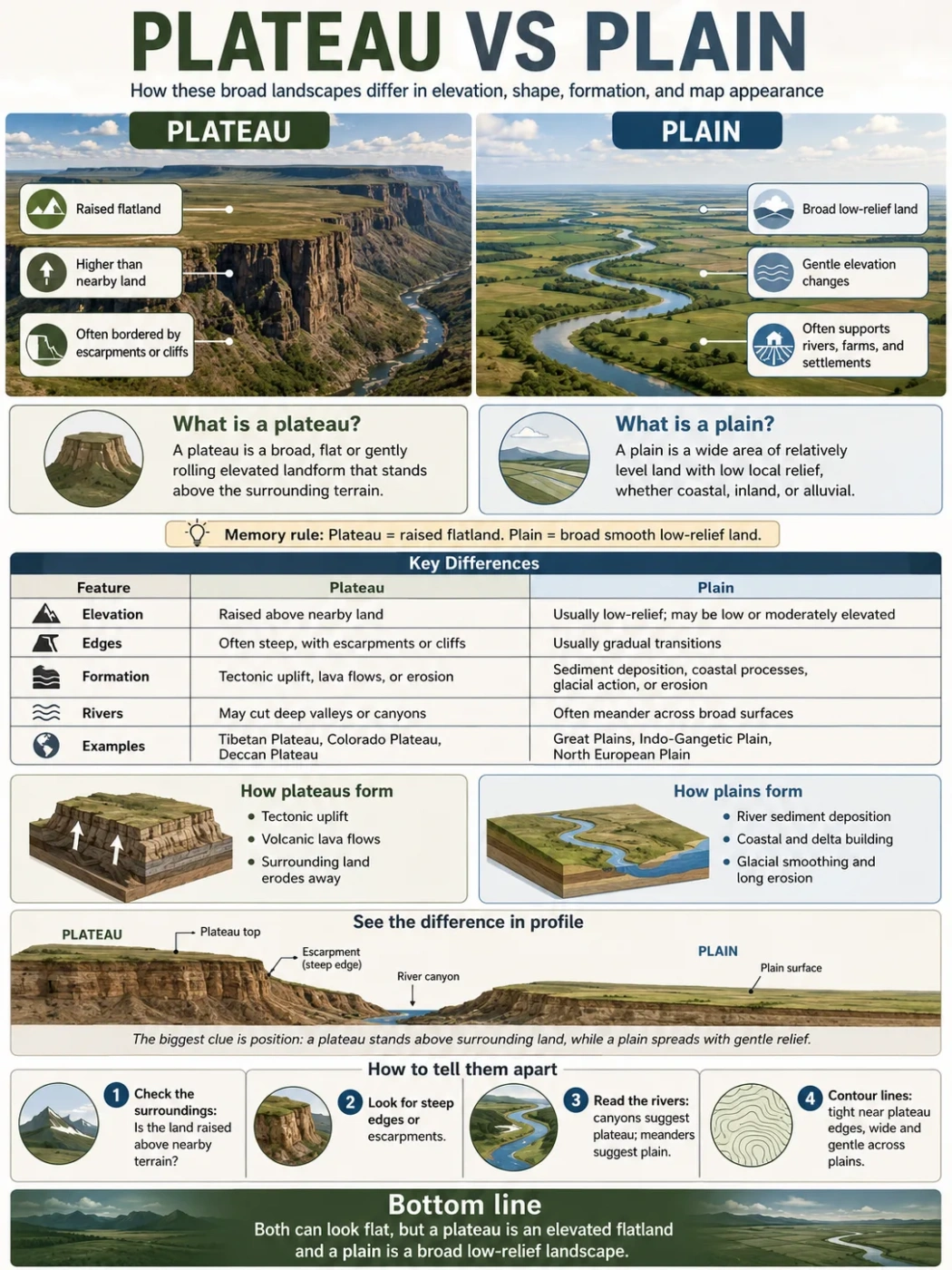
A plateau and a plain can both look wide and fairly flat, but they sit in different positions in the landscape. A plateau is a raised flat or gently rolling highland, while a plain is a broad low-relief area that may lie near sea level, inside a basin, along a coast, or across an inland region.
A plateau is not simply a “flat place.” A plain is not always perfectly flat either. The real difference is the way each landform sits against nearby terrain. A plateau usually rises above surrounding land, often with steep edges, escarpments, canyon walls, or mountain borders. A plain spreads with gentle slopes and small local relief, so the land changes height more slowly.
This is why the same map can show both landforms close together. A river may leave a high plateau through a canyon and then flow across a lower plain. A mountain range may feed sediment onto a plain, while an older raised surface nearby remains a plateau.
Landform Note
The simplest rule is this: a plateau is flat or gently rolling land that is high compared with nearby land. A plain is flat or gently rolling land with low local relief, whether it is low, coastal, inland, or part of a wide basin.
| Feature | Plateau | Plain |
|---|---|---|
| Basic Meaning | A broad, flat or gently rolling elevated landform | A broad, flat or gently rolling area with small local relief |
| Elevation Pattern | Usually raised above nearby land, often by hundreds or thousands of meters | May be low, coastal, inland, or moderately elevated, but the surface changes height gently |
| Edges | Often bordered by escarpments, cliffs, valleys, mountains, or steep slopes | Usually blends gradually into nearby land, though plains can meet hills, coasts, or mountains |
| Formation | Often formed by tectonic uplift, lava flows, erosion, or a mix of these processes | Often formed by sediment deposition, river activity, coastal processes, glacial action, or long erosion |
| Common Examples | Tibetan Plateau, Colorado Plateau, Deccan Plateau, Ethiopian Highlands | Great Plains, Indo-Gangetic Plain, North European Plain, coastal plains |
| Map Clue | Contour lines may show a raised surface with steep margins or deeply cut valleys | Contour lines are often widely spaced across large areas |
Short Answer: How a Plateau Differs From a Plain
A plateau is an elevated flatland. A plain is a broad flatland with gentle relief.
The difference is not only shape. It is also position. A plateau stands high compared with its surroundings. A plain spreads across a lower or smoother part of the landscape, often where rivers, glaciers, seas, or wind have laid down sediment or smoothed the surface over time.
A plateau may look like a table from a distance: a broad top with a sharper drop along one or more sides. A plain often looks more open and continuous, with fewer sharp breaks in elevation.
Simple Memory Rule: If the land is flat and raised like a high platform, think plateau. If the land is flat and wide with gentle changes in height, think plain.
What Is a Plateau?
A plateau is a flat or gently uneven highland. It may cover a small upland area or stretch across a large region. Some plateaus sit between mountain ranges. Others stand above deserts, river basins, grasslands, or coastal lowlands.
Many plateaus have one or more steep sides. These steep margins are often called escarpments. In other cases, a plateau is cut by rivers, canyons, and valleys, so its surface is no longer perfectly smooth. The plateau is still recognized because much of its land remains at a higher level than the surrounding country.
Common Plateau Features
- Raised surface compared with nearby land
- Flat, rolling, or partly dissected top
- Edges marked by cliffs, escarpments, valleys, or mountain slopes
- Rivers that may cut deep canyons or gorges
- Climate shaped by elevation, rain shadow effects, and distance from oceans
The Tibetan Plateau is often described as the highest and largest plateau region on Earth. The Colorado Plateau is known for canyon landscapes and deeply cut river systems. The Deccan Plateau in India is closely linked with ancient lava flows. These examples show that plateaus do not all form in one way.
What Is a Plain?
A plain is a broad area of relatively level land. It may be a grassland, farmland, coastal lowland, river floodplain, desert surface, or glacially smoothed landscape. The main point is that the surface has low local relief. Hills may exist, but they are usually gentle compared with mountains or plateau edges.
Plains are often linked with sediment. Rivers spread sand, silt, clay, and gravel across floodplains. Seas build coastal plains. Glaciers can smooth land and leave broad deposits behind. Wind can also shape dry plains by moving fine sediment across open ground.
Common Plain Features
- Wide, open, low-relief surface
- Gentle slopes rather than sharp elevation breaks
- Often crossed by rivers, streams, or drainage networks
- May support grasslands, farms, wetlands, settlements, or transport routes
- Can form near coasts, inside basins, along rivers, or across continental interiors
The Great Plains of North America, the Indo-Gangetic Plain of South Asia, and the North European Plain are well-known examples. Each has its own climate, soils, river systems, and human geography, but all share a wide, low-relief surface.
Field Note
A plain can still have hills, shallow valleys, dunes, river terraces, or low ridges. “Plain” does not mean mathematically flat. It means the land has gentle relief across a broad area.
Elevation Is the Main Clue, But Not the Only One
Elevation helps separate a plateau from a plain, but it should not be used alone. Some plains are high above sea level, especially in continental interiors. Some plateaus have surfaces that are broken by valleys and hills. The better question is: how does the land sit compared with nearby terrain?
A high plain may be elevated above sea level, but it usually lacks the sharp raised-platform form of a plateau. A plateau may be cut by erosion, but it still keeps a broad upland surface.
| Map Clue | Likely Plateau | Likely Plain |
|---|---|---|
| Contour Pattern | Flat or gently spaced contours on top, tighter contours near edges | Widely spaced contours over a large area |
| River Shape | Rivers may cut deep valleys or canyons into the upland | Rivers often meander across low-gradient land |
| Nearby Land | Surface stands above basins, plains, valleys, or lower country | Surface blends more gradually with nearby lowlands or basins |
| Edge Form | Escarpments, cliffs, steep slopes, or mountain borders are common | Sharp edges are less common, though plains may meet hills or coasts |
How Plateaus Form
Plateaus form when large areas of land are raised, built up, or left standing while nearby areas wear down. Their origin often controls their rocks, soils, rivers, and surface shape.
Tectonic Uplift
Some plateaus form when the Earth’s crust is pushed upward by tectonic forces. This can happen near mountain belts or within large continental regions. The land rises as a broad block rather than as a narrow mountain ridge.
The Tibetan Plateau is a classic example of a high plateau linked with plate movement and mountain building. Its elevation affects climate, glaciers, river sources, and weather patterns across a large part of Asia.
Volcanic Lava Flows
Other plateaus form from repeated lava flows. Lava spreads across broad areas, cools, and builds thick layers of volcanic rock. Over time, erosion may cut valleys into the surface.
The Deccan Plateau and the Columbia Plateau are often linked with this type of origin. These landscapes may have broad basalt surfaces, stepped slopes, and river-cut canyons.
Erosion and Resistant Rock
Some plateau surfaces remain high because surrounding softer rocks erode faster. The harder rock acts like a cap. As lower land wears away, a raised surface can stand out more clearly.
This process helps explain smaller tablelands, mesas, and dissected plateau edges in dry or semi-dry regions.
How Plains Form
Plains form in several ways, but many are shaped by deposition, long erosion, or both. A plain may be young and still receiving sediment, or old and worn down through long landscape change.
River Deposition
Rivers build alluvial plains by dropping sediment as they slow, flood, shift channels, or enter lower-gradient areas. These plains often have fertile soils because floods can renew fine sediment.
The Indo-Gangetic Plain is closely tied to large river systems and sediment carried from nearby highlands.
Coastal Processes
Coastal plains form near sea margins. They may include old seabeds, river deltas, beach ridges, marshes, lagoons, and low terraces. Their elevation is usually low, and drainage may be slow.
Glacial and Erosional Smoothing
Glaciers can flatten, scrape, and cover land with deposits. Long erosion can also reduce relief over time, leaving broad surfaces that behave like plains even when their bedrock history is complex.
Geography Note
Formation matters because two flat landscapes may look similar from the ground. A volcanic plateau, an alluvial plain, and a glacial plain can all appear open, but their rocks, soils, drainage, and edges tell different stories.
Shape and Relief: Why Flat Does Not Mean the Same Thing
Both plateaus and plains can look flat in photographs, satellite images, and classroom diagrams. The difference becomes clearer when the land is viewed in cross-section.
A plateau has a raised surface. It may drop down sharply to a valley, basin, plain, or lower plateau level. A plain has a smoother profile, with less sudden change in height.
Plateau Shape
- Often broad on top
- May have steep sides
- May be cut by deep valleys
- May sit between mountain ranges
- Can include smaller mesas, buttes, ridges, and basins
Plain Shape
- Usually wide and open
- Often slopes gently toward a river, sea, lake, or basin
- May include shallow river valleys
- Can include dunes, wetlands, terraces, or low hills
- Often supports easier movement, farming, and settlement than steep terrain
Climate Differences Between Plateaus and Plains
Climate does not define the landform, but it changes how each landform feels and functions.
Plateaus are often cooler than nearby lowlands because of elevation. High plateaus may have thin air, strong sunlight, large daily temperature swings, and short growing seasons. If a plateau sits behind mountains, it may also be dry because the mountains block moist air.
Plains vary widely. Some are humid and fertile. Some are dry grasslands. Some are coastal and low. Others sit in cold continental interiors. Since plains often have gentle slopes and deep sediment, they may support large farming areas where water and soil conditions allow.
| Topic | Plateau | Plain |
|---|---|---|
| Temperature | Often cooler due to elevation | Depends on latitude, ocean distance, and elevation |
| Wind Exposure | High surfaces can be windy and exposed | Open plains can also be windy, especially grasslands |
| Rainfall | May be wet on windward sides or dry in rain shadows | May be humid, semi-dry, arid, or coastal |
| Drainage | Rivers may cut down strongly into the raised surface | Rivers often spread across gentle gradients, floodplains, and deltas |
Rivers, Basins, and Escarpments
Rivers often reveal the difference between a plateau and a plain better than the surface alone.
On a plateau, a river may cut into bedrock and form a canyon, gorge, or steep-sided valley. The river is working from a higher surface down toward a lower base level. This can make plateau landscapes look rugged even when the original surface was broad and flat.
On a plain, rivers usually flow across gentler slopes. They may meander, split into distributaries, build floodplains, or leave natural levees. In low coastal plains, rivers may slow, spread, and create wetlands or deltas.
Common Mix-Up: A canyon does not automatically mean “mountain land.” Many famous canyons are cut into plateaus. The flat upland around the canyon is part of the plateau surface, even though the river valley itself is steep.
Examples of Plateaus and Plains
Real-world examples make the difference easier to see. The names below are not the only examples, but they show how varied both landforms can be.
| Landform | Type | Region | What It Shows |
|---|---|---|---|
| Tibetan Plateau | Plateau | Central and East Asia | A very high upland linked with tectonic uplift and nearby mountain ranges |
| Colorado Plateau | Plateau | Western United States | An elevated region cut by canyons, rivers, and escarpments |
| Deccan Plateau | Plateau | India | A broad upland region with volcanic rock across large areas |
| Great Plains | Plain | Central North America | A wide interior plain with grassland landscapes and gentle relief |
| Indo-Gangetic Plain | Plain | South Asia | A large alluvial plain shaped by major river systems and sediment |
| North European Plain | Plain | Northern Europe | A broad lowland corridor with low relief across several countries |
Why People Confuse Plateaus and Plains
People often confuse plateaus and plains because both can be wide, open, and easy to describe as “flat.” The confusion grows when a plateau surface is gently rolling or when a plain lies at a fairly high elevation.
Reason 1: Both Can Look Flat From the Ground
Standing on a plateau top, the horizon may look open and level. The steep edge may be far away, so the raised nature of the land is not obvious. The same can happen on a plain, where the surface stretches without sharp breaks.
Reason 2: Some Plains Are Not Low in Absolute Elevation
A plain does not have to sit at sea level. It can be inland and elevated. What matters is that the surface has gentle relief across a broad area. A high plain may be high above sea level but still not be a plateau if it does not stand as a raised tableland above nearby terrain.
Reason 3: Plateaus Can Be Deeply Eroded
Some plateaus are cut by rivers, valleys, and canyons. This can make them look rough on a map. Even so, the wider region may still be a plateau because much of the land belongs to an elevated upland surface.
Common Mix-Up
A plain describes broad low-relief land. A plateau describes broad raised land. The words can overlap in appearance, but not in landscape position.
Plateau vs Plain vs Mesa vs Basin
Plateaus and plains are also confused with nearby terms. The table below separates them in a practical way.
| Term | Basic Meaning | How It Differs |
|---|---|---|
| Plateau | Raised flat or gently rolling land | Higher than nearby land and often bordered by steep slopes |
| Plain | Broad flat or gently rolling land with low relief | Not defined by being raised above the surrounding land |
| Mesa | Smaller flat-topped highland | Usually smaller than a plateau, with steep sides and a table-like top |
| Basin | Low area where land slopes inward or drains toward a common center | Defined by drainage and lower position, not by a broad raised surface |
| Escarpment | Steep slope or long cliff-like edge | Often marks the side of a plateau, but is not the plateau itself |
Human Life on Plateaus and Plains
Plateaus and plains shape settlement, travel, farming, water use, and regional identity in different ways.
Plains often support dense transport networks and farming because the land is easier to cross and build on. River plains can have deep alluvial soils, though they may also face flooding. Coastal plains may support ports, wetlands, agriculture, and cities, depending on drainage and storm exposure.
Plateaus can support towns, grazing, farming, mining, tourism, and transport routes too, but elevation and slope matter more. Water may be limited in dry highlands. Roads may need to climb escarpments or cross canyon systems. High elevation can shorten growing seasons, while volcanic or alluvial soils in some plateau regions may support agriculture.
Neither landform is “better.” Each creates a different set of opportunities and limits.
How to Tell Them Apart in One Minute
When looking at a map, satellite image, or textbook diagram, use this order:
- Check the surroundings. Does the land stand high above nearby valleys, basins, or plains?
- Look for edges. Are there escarpments, steep slopes, or canyon walls around a broad surface?
- Read the rivers. Are rivers cutting down into raised land, or spreading across gentle low-gradient terrain?
- Think about formation. Was the land raised, built by lava, left by erosion, or built by sediment?
- Use the name carefully. Some regional names are traditional, so the physical landscape should still be checked.
Fast Rule: A plateau is a raised flatland. A plain is a wide low-relief surface. If the main feature is height above nearby land, choose plateau. If the main feature is broad smooth land, choose plain.
Mini FAQ
Is a plateau the same as a plain?
No. A plateau is a raised flat or gently rolling landform. A plain is a broad flat or gently rolling area with small local relief. They may look similar on the surface, but a plateau stands higher than nearby land.
Can a plain be high above sea level?
Yes. A plain can be elevated above sea level if its surface remains broad and gently sloping. Elevation alone does not make it a plateau. The land must also stand as a raised surface compared with its surroundings.
Why do plateaus often have canyons?
Plateaus often sit high above lower land, so rivers have energy to cut downward. Over long periods, this can form deep valleys, gorges, and canyons inside the plateau surface.
Are plains always good for farming?
No. Many plains support farming because they are flat and may have deep soils, but water, climate, soil quality, salinity, flooding, and drainage all matter. Some plains are dry, cold, sandy, or poorly drained.
What is the easiest way to remember plateau vs plain?
Think of a plateau as a raised platform of land and a plain as a broad smooth area. A plateau is defined by elevation above nearby land. A plain is defined by low relief across a wide surface.