Landform Comparison
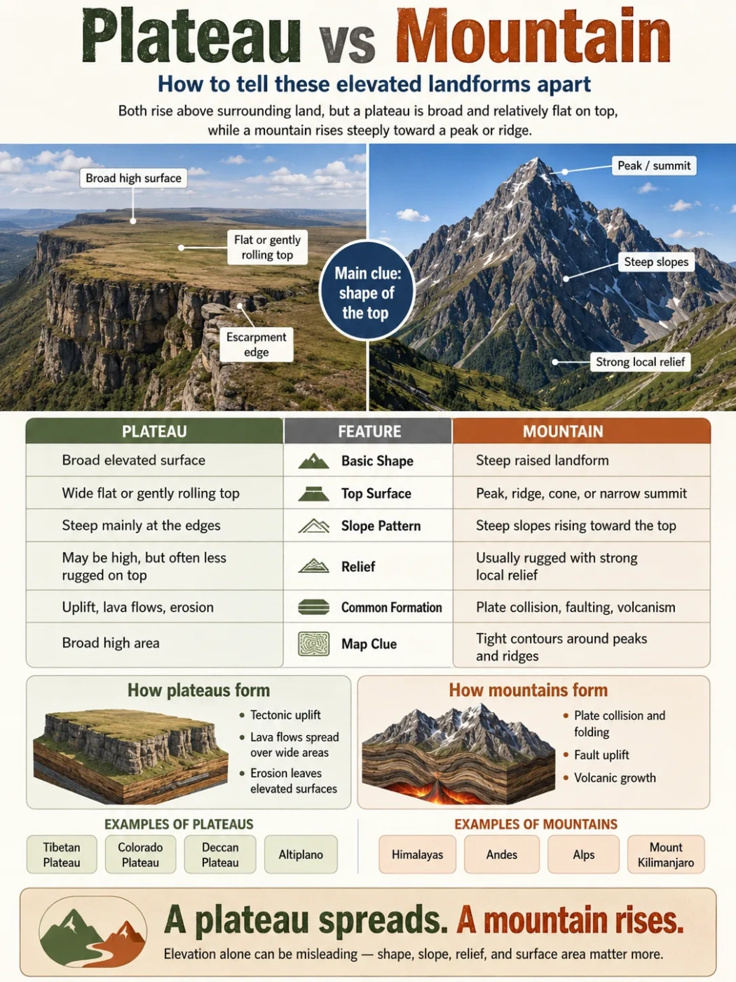
A plateau and a mountain can both rise high above nearby land, but they do not have the same shape. A plateau is mainly an elevated, broad, flatter land surface. A mountain is mainly a steep, high landform with a narrower summit, sharper slopes, and stronger local relief.
Mountain: steep highland
Main clue: summit shape
Often linked by uplift
A plateau is not just a “short mountain with a flat top.” A mountain is not just “any high place.” The real difference is the way the land rises, spreads, slopes, and connects with nearby terrain.
In map reading, the safest clue is not elevation alone. A high plateau can sit thousands of meters above sea level and still look broad and level across its surface. A mountain may rise from sea level or from a high plateau, but it stands out because it climbs sharply toward a more confined top.
Landform Note
The word elevation means height above sea level. The word relief means the height difference between nearby low and high points. Mountains usually have stronger local relief than plateaus.
Plateau vs Mountain: Short Answer
A plateau is an elevated landform with a broad, flat or gently rolling top. It often has steep sides, escarpments, cliffs, canyons, or eroded edges.
A mountain is a landform that rises prominently above nearby land, usually with steep slopes, rugged terrain, and a smaller summit area.
The easiest rule is simple:
- If the high land spreads out into a broad upper surface, it is likely a plateau.
- If the high land rises toward a peak, ridge, cone, or narrow summit, it is likely a mountain.
- If a flat-topped landform is small and isolated, it may be a mesa, not a full plateau.
| Feature | Plateau | Mountain |
|---|---|---|
| Basic Shape | Broad, flat or gently rolling elevated surface | Steep, raised landform with a smaller top area |
| Top Surface | Wide tableland, upland plain, or high basin surface | Peak, ridge, cone, crest, or narrow summit zone |
| Slope Pattern | Often steep at the edges but flatter across the top | Often steep from lower slopes toward the upper parts |
| Relief | Can be high above sea level but may have lower local relief on top | Usually has strong local relief and rugged terrain |
| Common Formation | Tectonic uplift, lava flows, erosion, or uplifted sedimentary layers | Plate collision, faulting, folding, volcanic growth, or uplift |
| Map Clue | Large elevated area with broad spacing between contour lines on top | Tight contour lines, steep slopes, peaks, ridges, and valleys |
| Examples | Tibetan Plateau, Colorado Plateau, Deccan Plateau, Altiplano | Himalayas, Andes, Alps, Rocky Mountains, Mount Kilimanjaro |
What Is a Plateau?
A plateau is a raised landform with a wide upper surface. It stands above nearby lowlands, valleys, plains, or basins, but its top is usually much flatter than a mountain slope.
Plateaus can cover small regions or vast areas. Some are dry and deeply cut by canyons. Some are volcanic and built from thick lava flows. Others sit inside mountain belts, where large parts of the crust have been lifted to high elevation.
The main idea is broad high ground.
Typical Features of a Plateau
- A raised land surface above surrounding terrain
- A flat, gently rolling, or basin-like upper area
- Steep edges in many places, often called escarpments
- Rivers that may cut deep valleys or canyons into the surface
- Climate patterns shaped by elevation, distance from oceans, and nearby mountains
Common Plateau Examples
The Tibetan Plateau is often described as the highest and largest plateau system on Earth, with many areas above 4,000 meters. It sits between major mountain ranges, including the Himalayas to the south and the Kunlun Mountains to the north.
The Colorado Plateau in the southwestern United States is known for high desert terrain, layered rocks, mesas, buttes, deep canyons, and river erosion. The Grand Canyon is cut into this plateau by the Colorado River system.
The Deccan Plateau covers a large part of peninsular India. Much of it is linked with old volcanic lava flows, later shaped by weathering, rivers, and long erosion.
The Altiplano in South America sits between parts of the Andes. It is a high plateau basin region shared mainly by Bolivia and Peru, with nearby mountain ranges, salt flats, lakes, and dry highland climate zones.
What Is a Mountain?
A mountain is a raised landform that stands strongly above nearby land. It usually has steep slopes, rugged sides, and a summit area that is much smaller than its base.
Mountains often appear in chains or belts. They can form through plate collision, fault movement, volcanic activity, or uplift followed by erosion. Some mountains have sharp peaks. Others have rounded tops after long weathering.
The main idea is steep high relief.
Typical Features of a Mountain
- Strong rise above the nearby landscape
- Steep slopes and clear vertical relief
- A summit, peak, crest, cone, or ridge
- Valleys, passes, cliffs, and drainage divides nearby
- Climate changes over short distances because of slope and height
Common Mountain Examples
The Himalayas are a major mountain belt formed by the collision of the Indian Plate with the Eurasian Plate. The range includes the highest mountains on Earth.
The Andes run along western South America and include volcanic peaks, high ridges, valleys, and nearby plateau regions such as the Altiplano.
Mount Kilimanjaro in East Africa is a volcanic mountain that rises above surrounding plains. Its shape is very different from a broad plateau, even though both are elevated landforms.
Shape Is the Main Difference
The most useful difference is shape, not just height.
A plateau spreads. A mountain rises.
A plateau may be high, but its upper surface often continues across a wide area. A mountain may be lower than some plateaus in absolute elevation, but it has steeper slopes and a stronger rise from base to summit.
Map Note
On a topographic map, a plateau may show a broad high area with more space between contour lines across the top. A mountain usually shows tight contour lines around steep slopes and a smaller summit area.
Elevation Can Be Misleading
Many people compare plateaus and mountains by asking which one is higher. That can lead to confusion.
A plateau can be extremely high. The Tibetan Plateau is higher than many named mountains in other regions. Yet it is still a plateau because much of its surface forms a broad elevated land area rather than one narrow peak.
A mountain can also rise from a plateau. In that case, the mountain’s summit may not look extremely high if measured from sea level alone, but it may still stand out clearly above the plateau surface around it.
Elevation Note
Elevation tells how high land is above sea level. It does not always tell whether the landform is a plateau or a mountain. Shape, slope, local relief, and surface area matter more for classification.
How Plateaus Form
Plateaus form in several ways. Some rise because large areas of the crust are lifted by tectonic forces. Others build up from repeated lava flows. Some are left behind after erosion removes softer surrounding rocks.
Tectonic Uplift
Large sections of the crust can rise over long periods. When uplift affects a wide region, the result may be a high plateau rather than one sharp mountain range.
The Tibetan Plateau is closely linked with the same plate collision system that built the Himalayas, but its broad surface makes it different from the steep mountain front to the south.
Volcanic Lava Flows
Some plateaus form when many lava flows spread over a wide area. Over time, stacked lava layers can create a broad volcanic tableland.
The Deccan Plateau and Columbia Plateau are often used as examples of large volcanic plateau landscapes, though both have been changed by erosion and river cutting since their formation.
Erosion and Dissection
Rivers and weathering can cut into a plateau after it forms. This creates canyons, mesas, buttes, cliffs, and isolated high surfaces.
A dissected plateau may look rugged from the ground, but the wider landform still has an older elevated surface behind the cut valleys.
How Mountains Form
Mountains usually form where the crust is strongly pushed, folded, faulted, uplifted, or built by volcanic activity. The result is land with steep relief and more dramatic height differences across shorter distances.
Plate Collision and Folding
When tectonic plates collide, rocks can fold, thicken, and rise. The Himalayas are the clearest large example of this process.
Faulting and Block Uplift
Some mountains rise along faults where parts of the crust move upward relative to nearby land. These mountains may have steep fronts and long ridges.
Volcanic Growth
Volcanic mountains form when lava, ash, and other volcanic material build upward around vents. Many have cone-like forms, though erosion can later soften their shape.
Can a Plateau Have Mountains?
Yes. A plateau can include mountains, hills, basins, valleys, cliffs, and volcanic cones. This is one reason the terms can be confusing.
A plateau describes the larger elevated surface. A mountain describes a steeper landform that rises within or beside that surface.
For example, the Tibetan Plateau is a broad highland region, but it is bordered and crossed by major mountain systems. The Altiplano is a plateau basin region within the wider Andes mountain belt. In these places, plateaus and mountains are not opposites. They are connected parts of the same larger terrain.
Geography Note
Some highland regions contain both landforms: a broad plateau surface and nearby mountain ridges. The name used depends on scale. A map of a continent may show the plateau, while a hiking map may focus on individual mountains and passes.
Plateau Edges vs Mountain Slopes
Plateaus can have steep sides. This does not automatically make them mountains.
The edge of a plateau is often an escarpment: a long steep slope or cliff-like margin where the high surface drops toward lower land. Mountains, by contrast, usually have slopes that rise toward a summit or ridge system.
| Landform Part | What It Looks Like | What It Usually Means |
|---|---|---|
| Plateau Top | Wide, elevated, flatter land | The main surface of the plateau |
| Plateau Escarpment | Steep edge or drop-off | The boundary between high plateau and lower terrain |
| Mountain Slope | Inclined land rising toward a summit | The side of a mountain |
| Mountain Summit | Peak, crest, cone, or narrow high point | The upper part of the mountain landform |
Rivers and Drainage Patterns
Rivers help show the difference between plateaus and mountains.
On a plateau, rivers may flow across a high surface before cutting deep valleys into it. Over long periods, these rivers can carve canyons and split the plateau into smaller tablelands.
In mountains, rivers often begin near high ridges, glaciers, snowfields, or steep headwaters. They flow down narrow valleys and may carry sediment from steep slopes into basins, plains, or plateau margins.
This creates a different drainage pattern:
- Plateau rivers may cut downward into a broad elevated surface.
- Mountain rivers often start in steep terrain and drop quickly through valleys.
- Plateau margins can create waterfalls, gorges, and steep river breaks.
Climate Differences Between Plateaus and Mountains
Both plateaus and mountains can affect climate. Elevation often makes air cooler. Slopes and mountain barriers can also shape rainfall, wind, snow, and dry zones.
Plateaus often have wide climate areas across their surface. A high plateau may be cold, dry, windy, or semi-arid, especially if it lies far from oceans or behind mountain rain shadows.
Mountains often show rapid climate shifts over short distances. Lower slopes may be warm, middle slopes may hold forests, and upper parts may have snow, alpine grassland, bare rock, or ice.
Common Mix-Up
A cold highland is not always a mountain. A broad cold upland can be a plateau. A steep tropical volcano can be a mountain even if its base starts in a warm region.
Why People Confuse Plateaus and Mountains
The confusion usually comes from three things: height, steep edges, and flat tops.
High Elevation
Both landforms can be high above sea level. This makes “high land” too vague as a definition.
Steep Sides
A plateau may have cliffs or escarpments. From below, its edge can look mountain-like. But the upper surface may still be broad and flat.
Flat-Topped Mountains and Mesas
Some mountains have flatter summits. Some mesas look like small plateaus. The difference often depends on scale. A mesa is usually an isolated flat-topped landform smaller than a broad plateau. A flat-topped mountain is still often read as a mountain if it rises steeply as a single landform.
Simple Rule for Remembering the Difference
Use this three-part test:
- Look at the top: broad flat surface means plateau; narrow summit means mountain.
- Look at the sides: plateau sides may be steep at the edge; mountain slopes rise toward a peak or ridge.
- Look at the scale: plateaus cover wider areas; mountains stand as individual peaks, ridges, or ranges.
A plateau is best understood as a raised surface. A mountain is best understood as a raised form.
Related Landforms Often Mixed With Plateaus and Mountains
| Term | Plain Meaning | How It Differs |
|---|---|---|
| Hill | A raised landform lower or less steep than a mountain in common use | Usually smaller and less rugged than a mountain, though naming varies |
| Mesa | An isolated flat-topped landform with steep sides | Usually smaller and more isolated than a plateau |
| Butte | A small isolated steep-sided landform, often with a flat or narrow top | Smaller than a mesa and far smaller than a plateau |
| Highland | A broad region of higher land | Can include plateaus, hills, mountains, and basins |
| Escarpment | A steep slope or long cliff-like edge | Often forms the edge of a plateau, not a whole mountain by itself |
| Basin | A lower or enclosed area where water or sediment may collect | Can sit inside plateaus or between mountains |
Plateau and Mountain Examples Side by Side
Real landscapes rarely fit into perfect textbook shapes. The examples below show how the terms work in practice.
| Example | Main Landform Type | Region | Why It Fits the Term |
|---|---|---|---|
| Tibetan Plateau | Plateau | Central and East Asia | Very broad highland surface connected with major mountain belts |
| Colorado Plateau | Plateau | Southwestern United States | Large elevated region cut by canyons, mesas, and river systems |
| Deccan Plateau | Plateau | Peninsular India | Wide upland area linked with old volcanic rocks and long erosion |
| Himalayas | Mountain Range | Asia | High, steep mountain belt with peaks, ridges, valleys, and strong relief |
| Andes | Mountain Range | Western South America | Long mountain belt with volcanic peaks, ridges, valleys, and nearby plateaus |
| Mount Kilimanjaro | Mountain | East Africa | Large volcanic mountain rising from surrounding lower terrain |
When a Landscape Can Be Both
Some places are described with both plateau and mountain language because they contain several landform levels.
A high plateau may sit inside a mountain belt. A mountain range may rise along the edge of a plateau. A volcanic plateau may include cones that are mountains. A dissected plateau may look mountainous after rivers cut it into ridges and valleys.
Scale solves much of the confusion:
- From a continental view, a broad region may be mapped as a plateau.
- From a local view, ridges and peaks inside it may be mapped as mountains.
- From a river view, the same region may be described by canyons, basins, and escarpments.
FAQ
Is a plateau the same as a mountain?
No. A plateau is a broad raised land surface, while a mountain is a steep raised landform with a smaller summit area. They can occur near each other, and a plateau can even contain mountains, but they are not the same landform.
Can a plateau be higher than a mountain?
Yes. A plateau can have a higher elevation above sea level than many mountains. Elevation alone does not decide the landform type. A broad high surface is still a plateau, while a steep landform with a summit is still a mountain.
How do I know if a landform is a plateau or a mountain?
Look at the shape. If the land has a wide elevated top with flatter terrain across the surface, it is likely a plateau. If it rises steeply toward a peak, ridge, cone, or narrow summit, it is likely a mountain.
Why do some plateaus have steep sides?
Many plateaus have steep edges because erosion, faulting, or river cutting exposes the boundary between the raised surface and lower land. These steep margins are often called escarpments.
Can mountains form on a plateau?
Yes. Mountains can rise on or beside a plateau. In large highland regions, the plateau describes the broad elevated surface, while mountains describe steeper peaks, ridges, or volcanic cones within that larger area.
Is a mesa a plateau or a mountain?
A mesa is a smaller, isolated flat-topped landform with steep sides. It is more like a small tableland or erosion remnant than a full plateau. Some mesas may look mountain-like from the side, but scale and surface shape separate them from broad plateaus.