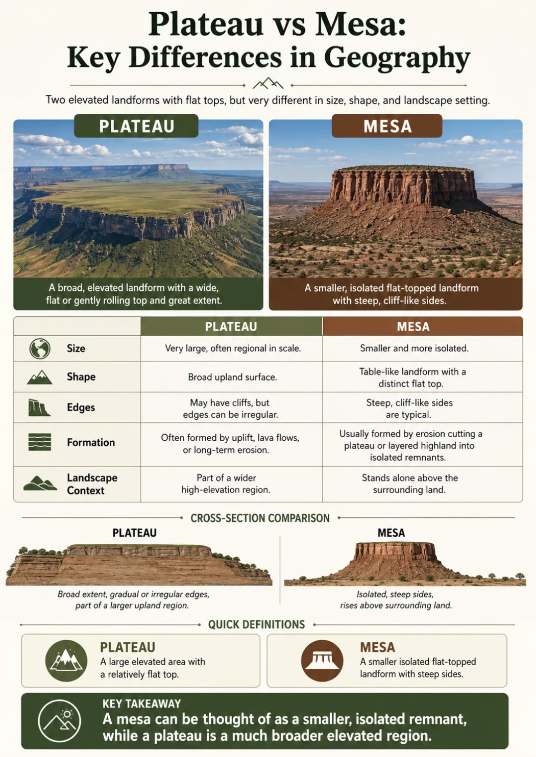
A plateau is a broad, raised area of land with a relatively flat surface. A mesa is a smaller, isolated, flat-topped landform with steep sides, often left behind when erosion cuts into a larger plateau or tableland. The simplest difference is scale, but the better geographic difference is extent, isolation, edge shape, and erosion history.
Short Answer: A plateau is a wide elevated region. A mesa is a flat-topped remnant or isolated highland, usually with cliffs or steep slopes on most sides. Many mesas form from the erosion of larger plateau surfaces.
Plateau vs Mesa: Main Difference
The main difference between a plateau and a mesa is not only size. A plateau can cover a large region, hold towns, rivers, farms, deserts, basins, and mountain ranges, and still keep a broad upland character. A mesa is more like a separate flat-topped high point that stands above lower land around it.
| Feature | Plateau | Mesa |
|---|---|---|
| Basic Meaning | A broad, raised, fairly flat landform | An isolated flat-topped hill, ridge, or tableland with steep sides |
| Scale | Usually regional or very wide | Usually smaller and more localized |
| Shape | Wide upland surface with one or more steep margins | Flat top with cliffs or steep slopes around much of the landform |
| Isolation | May connect to mountains, basins, plains, or other uplands | Often stands apart from nearby high ground |
| Formation | Can form by tectonic uplift, lava flows, erosion, or a mix of processes | Often forms by erosion of horizontal rock layers, leaving a resistant caprock |
| Typical Setting | Found on every continent in many climates | Common in dry or semi-dry regions with layered rock |
| Map Appearance | Large area of higher elevation, often with broad drainage networks | Small flat-topped high area surrounded by lower contour lines |
| Examples | Tibetan Plateau, Colorado Plateau, Deccan Plateau, Columbia Plateau | Mesa Verde area, Grand Mesa, Mount Conner, flat-topped mesas of the U.S. Southwest |
What Is a Plateau?
A plateau is an elevated landform with a wide, relatively flat surface. It rises above nearby lower land, often with steep slopes, escarpments, canyon edges, or mountain borders.
Some plateaus are high enough to affect climate and settlement. Others are lower but still stand out clearly from surrounding plains or basins. A plateau may contain valleys, rivers, cities, farms, deserts, forests, lava plains, and smaller landforms such as mesas and buttes.
Typical Plateau Features
- Large area: A plateau usually covers a broad region, not just one isolated hill.
- Relatively flat upland: The surface is flatter than nearby mountains, even when cut by rivers.
- Raised elevation: It sits higher than nearby plains, valleys, or basins.
- Steep edges: Many plateaus have escarpments, cliffs, canyon rims, or sharp slopes.
- Mixed origins: Plateaus may form from uplift, lava flows, erosion, or old rock surfaces raised over time.
Geography Note: A plateau does not have to be perfectly flat. Many plateaus are cut by rivers, canyons, valleys, and ridges. The word describes the broad raised surface, not a perfectly level floor.
What Is a Mesa?
A mesa is a flat-topped landform with steep sides. The word comes from Spanish and means “table,” which fits the landform’s table-like shape. In geography, a mesa is usually smaller than a plateau and more isolated from surrounding high ground.
Mesas often form where horizontal rock layers have different resistance to erosion. A hard upper layer protects softer layers below. As wind, rain, streams, and slope failure wear away nearby rock, a flat-topped remnant remains.
Typical Mesa Features
- Flat summit: The top is broad and table-like, though not always perfectly smooth.
- Steep sides: Cliffs, escarpments, or stepped slopes often surround the landform.
- Caprock: A harder rock layer may protect the top from faster erosion.
- Isolation: A mesa often stands apart from the main plateau or nearby uplands.
- Dry-region link: Mesas are common in arid and semi-arid landscapes where erosion exposes layered rock.
Why Size Alone Is Not Enough
Many simple explanations say a plateau is large and a mesa is smaller. That is useful, but it can be too simple. There is no single worldwide size limit that turns a mesa into a plateau.
The more useful test is shape and setting:
- If the landform is a broad raised region, it is usually a plateau.
- If it is an isolated flat-topped high area with steep sides, it is usually a mesa.
- If it is very small and its top is narrower than its height, it may be a butte.
A mesa can be part of a plateau landscape. For example, a large plateau may be cut by rivers and canyons, leaving mesas along its margins or within its eroded surface.
How Plateaus Form
Plateaus can form in several ways. This is one reason they vary so much from place to place.
Tectonic Uplift
Some plateaus rise when large sections of Earth’s crust are lifted. This may happen near plate boundaries or within broad regions affected by crustal movement. The Tibetan Plateau is the best-known high plateau linked to large-scale tectonic uplift.
Volcanic Lava Flows
Some plateaus form when repeated lava flows spread across wide areas and cool into layers of basalt. Over time, erosion cuts into the lava surface, but the broad upland remains. The Columbia Plateau in the northwestern United States is often described as a volcanic plateau.
Erosion and Dissection
Rivers can cut valleys and canyons into a raised surface. A once-smoother plateau may become a dissected plateau, with ridges, canyon walls, mesas, and isolated remnants.
How Mesas Form
Mesas usually form through differential erosion. This means softer rock layers wear away faster than harder layers. A resistant layer on top, often called caprock, protects the mesa summit while the surrounding material is removed.
The Basic Mesa Formation Process
- A region contains nearly horizontal layers of rock.
- A harder layer sits above softer layers.
- Streams, runoff, wind, and weathering cut into the landscape.
- Softer rock erodes faster around the edges.
- The harder caprock protects a flat top.
- The landform becomes isolated, with steep sides and a table-like summit.
Landform Note: A mesa is often an erosion remnant. It can show where a wider plateau or rock surface once extended before streams and slope erosion removed surrounding material.
Shape and Elevation Differences
Both plateaus and mesas are elevated. The difference is how that elevation spreads across the landscape.
Plateau Shape
A plateau spreads across a wider upland. Its edges may be steep, but the interior can include many land uses and landforms. A plateau can hold river basins, towns, roads, farms, forests, grasslands, deserts, or glaciers depending on elevation and climate.
Mesa Shape
A mesa has a clearer table-like form. It often rises above lower land around it and has steep sides. The top may be wide enough to walk or build on, but the landform still feels separate from the surrounding terrain.
Elevation Is Not the Deciding Factor
A high landform is not automatically a plateau, and a lower one is not automatically a mesa. Some plateaus sit at very high elevations. Some mesas rise only modestly above nearby plains. The deciding clues are surface extent, isolation, side steepness, and landform setting.
Plateau, Mesa, Butte, and Tableland
Plateaus and mesas are often confused with other flat-topped landforms. The terms overlap in everyday use, but geography gives each one a useful role.
| Landform | Simple Meaning | How It Differs |
|---|---|---|
| Plateau | Wide elevated flat or gently rolling upland | Much broader than a mesa; may contain rivers, basins, cities, and smaller landforms |
| Mesa | Isolated flat-topped highland with steep sides | Smaller and more separate than a plateau; often erosion-shaped |
| Butte | Small flat-topped or steep-sided remnant | Usually smaller than a mesa; often taller than it is wide at the top |
| Tableland | Broad flat upland or table-like highland | Can be used for plateau-like regions or wide flat-topped uplands |
| Escarpment | Steep slope or cliff forming an edge | Not the flat-topped landform itself; often forms the side of a plateau or mesa |
Map-Reading Difference
On a physical map, a plateau usually appears as a broad high-elevation area. It may stretch across a large part of a country or region. Its edges can show sharp relief, while its interior may show gentler elevation changes.
A mesa appears as a smaller raised feature with contour lines close together around its sides and a flatter area on top. If the map shows it separated from a larger upland by lower ground, that isolation supports the mesa label.
A Simple Rule for Reading the Landscape
- Wide raised region: likely a plateau.
- Flat-topped isolated remnant: likely a mesa.
- Small steep-sided tower or knob: likely a butte.
- Sharp cliff-like edge: likely an escarpment, not the whole landform.
Examples of Plateaus
Plateaus occur in many climates and geologic settings. They may be high, dry, volcanic, dissected, or bordered by mountains.
Tibetan Plateau
The Tibetan Plateau is one of the highest and largest plateau regions on Earth. It sits in Central and East Asia and is closely linked with the Himalaya and surrounding mountain systems. Its high elevation affects climate, river sources, and settlement patterns across a wide region.
Colorado Plateau
The Colorado Plateau covers parts of the southwestern United States. It is known for broad uplands, canyons, cliffs, mesas, buttes, and layered rock landscapes. Rivers such as the Colorado River and its tributaries have cut deeply into parts of the plateau.
Deccan Plateau
The Deccan Plateau covers a large part of peninsular India. Much of it is linked with ancient volcanic lava flows. It includes varied terrain, river systems, uplands, and dry to seasonally wet climates.
Columbia Plateau
The Columbia Plateau in the northwestern United States formed from large basalt lava flows. Later erosion and river cutting shaped its canyons, valleys, and rolling upland surfaces.
Examples of Mesas
Mesas are especially visible in dry landscapes where sparse vegetation and exposed rock layers make their shape easy to see.
Grand Mesa
Grand Mesa in Colorado is often described as one of the largest flat-topped mountains in the world. Its broad summit and steep margins make it a strong example of a mesa-like highland, though naming can vary with local geology and scale.
Mesa Verde Area
The Mesa Verde region in the southwestern United States has flat-topped uplands, steep canyon walls, and deeply cut drainage patterns. The name itself reflects the mesa landform, meaning “green table” in Spanish.
Mount Conner
Mount Conner in central Australia is a well-known flat-topped landform with steep sides. It is often described as a mesa or table-like mountain because of its isolated form and broad top.
Why People Confuse Plateaus and Mesas
People confuse plateaus and mesas because both are raised and flat-topped. Both can have steep sides. Both may appear in dry landscapes. The difference becomes clearer when the whole landform is viewed in context.
Common Mix-Ups
- “All flat-topped highlands are plateaus.” Not always. A small, isolated flat-topped highland may be a mesa.
- “A mesa is just a tiny plateau.” Sometimes that helps, but a mesa is also defined by isolation and steep sides.
- “A plateau must be perfectly flat.” No. Many plateaus are deeply cut by rivers and canyons.
- “A mesa and a butte are the same.” They are related, but a butte is usually smaller and has a more limited top.
Formation Difference in Plain Terms
A plateau is often made by uplift, lava, or broad erosion surfaces. A mesa is often made by erosion cutting away parts of a plateau or layered rock landscape.
That means a plateau can be the larger parent surface, while a mesa can be a remaining piece of that surface. This is especially common where streams cut into uplands and leave flat-topped remnants behind.
Climate and Landscape Context
Plateaus can appear in many climate zones. Some are cold and high. Some are dry and rocky. Some support grasslands, forests, farms, or urban areas. Their elevation can affect temperature, rainfall, snow, wind exposure, and river flow.
Mesas are strongly associated with dry and semi-dry regions, especially where rock layers are exposed and erosion is slow enough to preserve steep cliffs. They can also appear in other settings if the geology and erosion pattern fit.
Rivers, Basins, and Escarpments
Rivers help shape both plateaus and mesas, but they do so at different scales.
Rivers on Plateaus
On a plateau, rivers may cut long canyons, drain broad basins, or divide the upland into ridges and smaller tablelands. Over time, a dissected plateau can contain many mesas and buttes along its eroded edges.
Drainage Around Mesas
A mesa often sheds runoff from its flat top toward steep slopes. Small streams, gullies, and slope erosion can undercut softer layers below the caprock. This process helps cliffs retreat and can make the mesa smaller over time.
Escarpments as Edges
An escarpment is a steep slope or cliff-like edge. Plateaus may have long escarpments along their margins. Mesas may have escarpments on several sides, giving them their table-like profile.
Simple Memory Rule
Use this rule when the difference feels unclear:
- Plateau: Think “raised region.”
- Mesa: Think “isolated table.”
- Butte: Think “smaller rock tower.”
If the landform is broad enough to act like a region, it is probably a plateau. If it stands apart as a flat-topped feature above lower land, it is probably a mesa.
Mini FAQ
Is a mesa a type of plateau?
A mesa can be understood as a smaller, isolated flat-topped landform related to plateau landscapes. Many mesas form when erosion cuts into a larger plateau or tableland and leaves a flat-topped remnant behind.
What is the easiest way to tell a plateau from a mesa?
The easiest way is to look at scale and isolation. A plateau is a broad raised region, while a mesa is an isolated flat-topped highland with steep sides.
Can a plateau contain mesas?
Yes. A large plateau can contain mesas, buttes, canyons, river valleys, escarpments, and basins. This is common in dissected plateau landscapes.
Is a mesa bigger than a butte?
Usually, yes. A mesa generally has a wider flat top than a butte. A butte is often smaller and may have a top that is narrower compared with its height.
Do plateaus and mesas form the same way?
Not always. Plateaus can form through uplift, lava flows, erosion, or combined geologic processes. Mesas more often form when erosion leaves a resistant flat-topped remnant with steep sides.