Landform Comparison
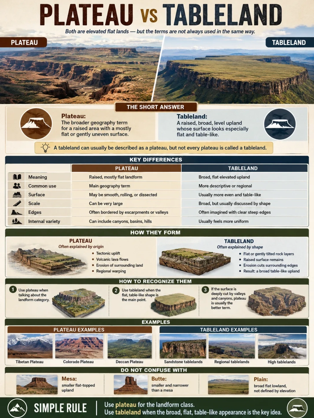
A plateau and a tableland both describe raised, mostly level ground, but they are not always used in the same way. Plateau is the broader geography term. Tableland usually points to a flat-topped upland whose surface looks especially broad, level, and table-like.
A plateau is an elevated landform with a relatively flat or gently uneven surface. It rises above nearby lower land, often along at least one steep side. A tableland is also elevated and flat, but the word is often used when the land looks like a broad table surface, especially in older geography writing, regional names, and map descriptions.
In many everyday uses, the two words overlap. A tableland can be a plateau. But in careful landform description, plateau is more flexible, while tableland sounds more visual and surface-focused.
Common Mix-Up
All tablelands can usually be described as plateaus, but not every plateau is called a tableland. Some plateaus are deeply cut by rivers, broken into basins, or tied to mountain belts, so they do not always look like one smooth tabletop.
Plateau vs Tableland: The Short Answer
A plateau is the standard landform term for a broad, elevated area with low surface relief compared with nearby mountains. A tableland is a broad, level elevated area too, but the word often stresses the table-like shape of the surface.
| Feature | Plateau | Tableland |
|---|---|---|
| Basic meaning | A raised, mostly flat or gently uneven landform | A broad, flat elevated landform with a table-like surface |
| Common use | Main term in geography, geology, textbooks, and landform classification | Often used in regional names, map labels, and descriptive writing |
| Surface shape | Can be smooth, rolling, dissected, volcanic, or basin-like | Usually suggests a flatter, more even upland surface |
| Edges | Often bordered by escarpments, mountains, valleys, or lower plains | Often imagined with clear edges or escarpment-like margins |
| Scale | Can range from local uplands to huge continental-scale regions | Usually broad, but the word is less strict as a technical size category |
| Best example use | Colorado Plateau, Tibetan Plateau, Deccan Plateau | Central tablelands, high tablelands, sandstone tablelands |
What Is a Plateau?
A plateau is a high area of land that stays relatively flat across its upper surface. It may rise sharply above nearby lowlands, sit between mountain ranges, or stretch across a large interior region.
The surface does not have to be perfectly level. Many plateaus contain hills, valleys, canyons, lava fields, dry basins, river systems, and smaller uplands. The main idea is that the land is elevated and has a broad upper surface compared with the surrounding terrain.
How Plateaus Form
Plateaus can form in several ways. The most common processes include:
- Tectonic uplift: large blocks of crust rise slowly, often near mountain belts.
- Volcanic activity: repeated lava flows spread across wide areas and build a raised surface.
- Erosion: softer rock around a resistant upland wears away, leaving higher flat ground behind.
- Regional warping: broad crustal bending raises land without forming a sharp mountain ridge.
This is why plateaus do not all look the same. The Tibetan Plateau is tied to large-scale mountain building. The Deccan Plateau is linked to volcanic lava flows. The Colorado Plateau is famous for uplifted rock layers carved by rivers and canyons.
Landform Note
A plateau is not simply “flat land.” It is flat or gently uneven land at a raised position. Elevation and surrounding relief matter more than surface smoothness alone.
What Is a Tableland?
A tableland is a raised area with a broad, level, table-like surface. The word is close to plateau, but it often feels more descriptive. It tells the reader how the land looks from a distance or on a map.
Tablelands are often linked with escarpments, cliffs, flat-lying rock layers, and gently rolling upland surfaces. In some regions, “tableland” appears in place names for upland districts, farming regions, or elevated interior areas.
Why the Word Tableland Still Matters
The term helps when the shape is the main point. A tableland suggests a wide elevated surface that is easier to picture than a complex plateau cut by deep river valleys.
For example, a broad sandstone upland with a flat top and steep sides may be called a tableland because its shape is visually clear. A very large uplifted region with mountains, basins, valleys, and dry plains inside it is more often called a plateau.
Main Differences Between a Plateau and a Tableland
1. Plateau Is the Broader Geography Term
Plateau is the safer and more widely used term in physical geography. It can describe many raised landforms, including volcanic plateaus, dissected plateaus, intermontane plateaus, and continental plateaus.
Tableland is narrower in tone. It usually describes the appearance of the land rather than its full geologic origin.
2. Tableland Emphasizes Shape More Strongly
The word tableland points to a landform that looks like a table: raised, broad, and fairly level on top. It is useful when the upper surface is visually clear and not too broken by ridges or deep valleys.
A plateau may also look like a tableland, but it does not have to. Some plateaus are rugged, dissected, or partly enclosed by mountain ranges.
3. Plateau Can Include More Internal Variety
Large plateaus often contain many smaller landforms. A plateau may include:
- river canyons and tributary valleys
- upland basins
- volcanic plains
- mesa-like remnants
- badlands, cliffs, and escarpments
- mountain-front valleys and dry interior drainage areas
A tableland is usually described as more uniform. It may still have streams and gentle relief, but the flat upper surface remains the main visual feature.
4. Map Labels May Use Them Differently
On maps, plateau often names a large physical region. Tableland may appear as a regional or local label, especially where the land rises as a flat upland above nearby valleys, coastal plains, or low basins.
Map Note
If a map labels an area as a plateau, expect a raised landform region. If it labels an area as tableland, look for a broad flat upland surface, often with a clear edge dropping toward lower ground.
Shape and Elevation Difference
Both plateaus and tablelands sit above nearby land. The difference is not measured by one fixed height. There is no universal elevation line where a plateau becomes a tableland or the other way around.
The distinction depends on relative elevation, shape, and use. A landform can be 500 meters above sea level and still act like a plateau if it rises clearly above its surroundings. Another upland may stand much higher but still be called a tableland if it has a broad, level, table-like surface.
| Landform Trait | More Likely Called Plateau | More Likely Called Tableland |
|---|---|---|
| Very large raised region | Yes, especially in global geography | Sometimes, but less common for huge complex regions |
| Flat upper surface | Common, but not always smooth | Central to the meaning |
| Deep river dissection | Still can be a plateau | Less likely if the surface no longer reads as table-like |
| Steep outer edge | Common along escarpments | Very common in the visual idea of a tableland |
| Use in landform classification | Very common | Less common as a strict class |
Simple rule: use plateau when talking about the landform category. Use tableland when the flat, table-like appearance is the point.
Formation Difference
A plateau is usually discussed through its origin. A tableland is usually discussed through its shape. This is the clearest practical difference.
Plateau Formation
Plateaus may form through uplift, lava flows, long erosion, or a mix of processes. Their origin can be complex. A plateau may rise with nearby mountains, spread from volcanic rock, or remain high because resistant rock protects it from faster erosion.
Tableland Formation
Tablelands often form where flat or gently tilted rock layers remain as a raised surface. Over time, erosion cuts into the edges and lowers nearby land. The result can be a flat-topped upland with scarps, cliffs, or steep slopes around it.
This does not mean every tableland has the same origin. Volcanic rocks, sedimentary layers, and uplifted surfaces can all produce table-like uplands. The word mainly describes what the landform looks like after these processes shape it.
Rivers, Basins, and Escarpments
Rivers help reveal the difference between a smooth tableland and a more complex plateau. On a high, broad plateau, rivers may cut deep valleys, form canyons, or drain into interior basins. Over long periods, flowing water can divide a once-smoother surface into smaller blocks and ridges.
A tableland may also have streams, but the surface often remains easier to read as one raised, level area. Its edges may stand out more than its internal drainage pattern.
Why Escarpments Matter
An escarpment is a steep slope or cliff-like edge between higher and lower ground. Plateaus often have escarpments, especially where uplift or erosion creates a sharp boundary. Tablelands often depend on this edge visually: the flat top looks more table-like when it drops away clearly on one or more sides.
Geography Note
On a shaded relief map, a plateau may appear as a large raised block with many internal valleys. A tableland may appear as a flatter upland surface with a cleaner outer edge.
Examples That Show the Difference
Real place names do not always follow strict rules. Some regions called plateaus include tableland-like surfaces, and some tablelands could be described as plateaus. The examples below show how the words are usually understood.
| Example | Usually Called | Why This Term Fits |
|---|---|---|
| Tibetan Plateau | Plateau | A vast highland region tied to uplift and mountain-building processes |
| Colorado Plateau | Plateau | A large raised region with canyons, mesas, basins, and river-cut terrain |
| Deccan Plateau | Plateau | A broad upland region strongly linked with ancient volcanic lava flows |
| Sandstone tablelands | Tableland | Flat or gently rolling uplands where resistant rock forms broad raised surfaces |
| Regional “Tablelands” in place names | Tableland | Often used for elevated districts with broad upland surfaces |
Plateau, Tableland, Mesa, Butte, and Plain
Plateau and tableland are often confused with other flat or elevated landforms. The difference usually comes down to scale, edge shape, and position above nearby land.
| Term | Simple Meaning | How It Differs |
|---|---|---|
| Plateau | Broad raised land with a fairly level surface | The main landform category for elevated flat regions |
| Tableland | Flat elevated land with a table-like surface | More visual and descriptive; often treated as a type or synonym of plateau |
| Mesa | Flat-topped hill or small upland with steep sides | Usually smaller and more isolated than a plateau |
| Butte | Small steep-sided flat-topped hill | Smaller and narrower than a mesa |
| Plain | Broad flat or gently rolling lowland | Not defined by being raised above surrounding land |
| Highland | Elevated region, often hilly or mountainous | Does not need a flat upper surface |
Do not judge by flatness alone. A plain can be flat, a mesa can be flat-topped, and a plateau can be deeply cut by valleys. Elevation above surrounding land is part of the test.
When Should You Use Plateau or Tableland?
Use Plateau When
- the topic is a landform type in physical geography
- the raised area is large or regionally important
- the landform has a known geologic origin, such as uplift or lava flows
- the surface includes canyons, basins, hills, or river-cut valleys
- the place name already uses “Plateau”
Use Tableland When
- the flat, table-like top is the main feature
- the land is a broad upland rather than a small isolated mesa
- the term appears in a regional place name
- the landscape is being described visually from a map, road, valley, or escarpment
- the surface feels more uniform than a rugged dissected plateau
A clean way to remember it: plateau explains the landform class; tableland describes the table-like look.
How to Recognize Them on a Map
On a physical map or shaded relief map, start with elevation. Look for a wide area that sits higher than nearby land. Then check the surface pattern.
Signs of a Plateau
- large elevated region shown by broad color bands or contour spacing
- edges marked by slopes, escarpments, or mountain fronts
- internal valleys, canyons, basins, or river networks
- place names ending in “Plateau” or “High Plateau”
Signs of a Tableland
- raised surface that looks broad and fairly even
- clear drop toward surrounding valleys or lower plains
- fewer large internal ridges than a rugged plateau
- place names using “Tableland,” “Tablelands,” or “Table Mountain” nearby
Contour lines can help. A flat upland has wider-spaced contours across the top. A steep outer edge has tighter contour lines along the side.
FAQ
Is a tableland the same as a plateau?
Often, yes. A tableland is usually a kind of plateau or a near synonym for plateau. The difference is that tableland stresses the broad, flat, table-like surface, while plateau is the wider geography term.
What is the main difference between a plateau and a tableland?
The main difference is usage. Plateau is the standard landform category. Tableland is more descriptive and is often used when the raised land looks especially flat and table-like.
Can a plateau have hills and valleys?
Yes. A plateau can contain hills, canyons, basins, and river valleys. It only needs to be a broad elevated region with relatively low relief compared with mountain terrain around or within it.
Is a mesa a tableland?
A mesa is a flat-topped landform, but it is usually smaller and more isolated than a tableland or plateau. A tableland is broader, while a mesa stands out more like a separate flat-topped hill or upland remnant.
Why do some maps use tableland instead of plateau?
Some maps use tableland because the local landform has a broad, level upland surface. The term may also come from older regional naming traditions. In many cases, the same area could still be described as a plateau in general geography.
How do I know if raised flat land is a plateau, tableland, or plain?
Check the land’s position. If it is broad and flat but not clearly raised, it may be a plain. If it is raised above nearby land, it may be a plateau. If the raised surface looks especially broad, flat, and table-like, tableland may also fit.