A plateau, a mountain, and a plain can all cover large areas of land, but they do not describe the same shape. The easiest difference is this: a plateau is high and fairly flat, a mountain is high and steep, and a plain is broad and mostly flat, often with little change in height.
The real difference is not only height. Geographers also look at relief (how much the land rises or falls nearby), slope, surface shape, edges, formation, drainage, and how the land connects to nearby rivers, basins, escarpments, and mountain ranges.
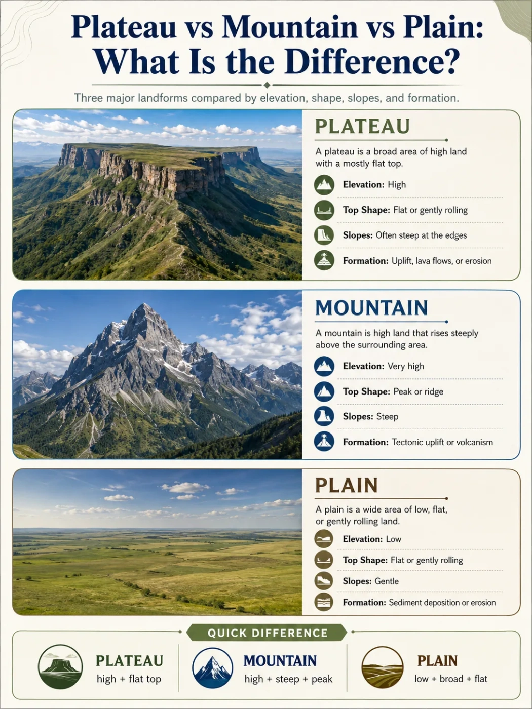
Short Answer: Plateau vs Mountain vs Plain
| Landform | Simple Meaning | Typical Shape | Elevation Pattern | Common Clue on a Map |
|---|---|---|---|---|
| Plateau | An elevated area with a broad, fairly level surface | Flat or rolling top with steep edges in places | Higher than nearby land, but not always sharply peaked | Wide highland area, often cut by valleys or bounded by escarpments |
| Mountain | A landform that rises strongly above surrounding land | Steep slopes, ridges, peaks, or narrow summits | High local relief, with rapid height change over short distance | Tight contour lines, ridgelines, peaks, and mountain chains |
| Plain | A broad area of relatively flat land | Flat, gently rolling, or low-slope surface | Usually low relief, though plains can occur at different elevations | Open, broad surface with widely spaced contour lines |
Geography Note: Height alone does not define the landform. A high plain can be flat and elevated, while a low mountain can still be steep. Shape and local relief matter as much as absolute elevation.
What Is a Plateau?
A plateau is a raised landform with a broad top that is relatively flat compared with nearby mountains or hills. It may sit thousands of meters above sea level, or it may rise only moderately above nearby lowlands. The defining feature is the combination of elevation and low-to-moderate surface relief.
Many plateaus have steep sides called escarpments. Others are enclosed by mountains or broken by canyons, valleys, and river basins. A plateau can look flat from a distance, but its surface may include mesas, buttes, lava fields, grasslands, dry basins, towns, farms, and deeply cut river channels.
Main Features of a Plateau
- Raised land: A plateau stands higher than surrounding areas on at least one side.
- Broad upper surface: The top is often flat, gently rolling, or table-like.
- Edges or escarpments: Many plateaus end in steep slopes or cliffs.
- River cutting: Rivers may carve deep valleys or canyons into the plateau surface.
- Wide extent: Some plateaus cover huge regions across states, provinces, or countries.
How Plateaus Form
Plateaus form in several ways. Some rise when large blocks of crust are lifted by tectonic uplift. Others form from repeated lava flows that spread across wide areas and harden into volcanic rock. Some plateaus are older highlands that have been worn down by erosion until their surfaces become broader and less rugged.
The Colorado Plateau in the southwestern United States, the Deccan Plateau in India, and the Tibetan Plateau in Asia are all plateaus, but they do not share one simple origin story. Their shapes reflect different mixes of uplift, volcanic activity, river erosion, climate, and long-term landscape change.
Why Plateaus Are Often Cut by Rivers
Plateaus are high enough for rivers to gain energy as they flow toward lower basins. Over time, this can create deep valleys, gorges, and canyons. This is why a plateau may have a flat regional surface but still contain sharp local landforms.
A river crossing a plateau often acts like a saw. It lowers its channel while the surrounding highland remains broad and elevated.
What Is a Mountain?
A mountain is a landform that rises prominently above the land around it. Mountains usually have steep slopes, strong local relief, and a summit area that is smaller than the broad top of a plateau. They often occur in ranges, belts, chains, volcanic arcs, or uplifted blocks.
The word “mountain” is not defined by one universal height. In many places, a mountain is recognized by its steepness, relief, and shape rather than by a single elevation number.
Main Features of a Mountain
- Steep slopes: Mountains rise quickly from nearby land.
- High local relief: The height difference between valley and summit is usually large.
- Peak or ridge: Mountains commonly have summits, ridgelines, or narrow crests.
- Linked ranges: Many mountains form part of longer chains or belts.
- Strong climate effect: Mountains can shape rainfall, snow, wind, and temperature patterns.
How Mountains Form
Mountains form through processes that lift, fold, break, or build the crust. Fold mountains form where tectonic plates press rock layers together. Fault-block mountains rise when large crustal blocks move along faults. Volcanic mountains build up from erupted material. Dome mountains form where uplift pushes rock upward without creating a classic folded range.
Unlike a plateau, a mountain usually does not have a broad, level top. Its shape is more vertical, more rugged, and more strongly tied to ridges, slopes, and summit relief.
Elevation Note: A mountain can be lower than a plateau in absolute elevation and still be a mountain. The reason is local relief. A steep mountain rising from a valley may look and function like a mountain even if a distant plateau sits higher above sea level.
What Is a Plain?
A plain is a broad area of mostly flat or gently rolling land. Plains usually have low local relief, meaning the land does not rise or fall sharply over short distances. They may occur near sea level, along coasts, beside rivers, below mountains, or within large continental interiors.
Plains are not always perfectly flat. Many plains include shallow valleys, low ridges, wetlands, river terraces, grasslands, farmland, or dry steppe. What matters is that the overall surface remains open and relatively even.
Main Features of a Plain
- Broad surface: Plains often stretch across large regions.
- Low relief: Elevation changes are usually gentle.
- Easy drainage patterns: Rivers may meander, branch, flood, or deposit sediment.
- Many origins: Plains can form by sediment deposition, erosion, lava flows, or coastal processes.
- Human use: Many plains support farming, transport routes, towns, and large settlements because the terrain is easier to cross.
How Plains Form
Plains may form when rivers deposit sediment across floodplains, when waves and coastal processes shape lowlands, when glaciers leave broad surfaces behind, or when long erosion lowers a landscape. Some plains also form from lava flows that spread across wide areas and later become low-relief surfaces.
A plain can be high or low. The term describes surface shape more than height. This is why phrases like high plain, coastal plain, and alluvial plain can all be correct.
The Core Difference Is Shape, Relief, and Position
Plateaus, mountains, and plains are often taught as separate landforms, but real landscapes can blend into one another. A plateau may border a mountain range. A plain may sit below an escarpment. A mountain chain may rise from a plateau surface.
The best way to separate them is to look at three things: surface shape, local relief, and position compared with nearby land.
| Question to Ask | Plateau | Mountain | Plain |
|---|---|---|---|
| Is the land elevated? | Yes, usually above nearby lowlands | Yes, usually rising sharply | Not necessarily; often low, but can be higher |
| Is the surface broad and fairly flat? | Yes | No, usually sloped or rugged | Yes |
| Are the edges steep? | Often, especially along escarpments | Usually steep on many sides | Usually gentle, unless bordered by cliffs or mountains |
| Does it have a summit or peak? | Usually no single peak | Often yes | No |
| What landform does it resemble from a distance? | A raised table or upland block | A steep high mass, ridge, cone, or chain | An open flat or gently rolling surface |
Plateau vs Mountain
A plateau is high but broad and often flat on top. A mountain is high and steep, with stronger relief and a more pointed, ridged, or rugged form.
This difference becomes clearer on a topographic map. A mountain often shows tight contour lines around a summit or ridge. A plateau may show a large elevated surface with more widely spaced contours across the top and steeper contour lines along its edges.
Simple Rule
If the land rises high and then spreads into a broad upper surface, it is likely a plateau. If it rises steeply toward a peak, ridge, or narrow crest, it is more likely a mountain.
Where the Confusion Happens
Some high plateaus are surrounded by mountains, so people may call the whole region “mountainous.” The Tibetan Plateau is a good example of a very high plateau linked to some of the world’s tallest mountain systems. The plateau itself is a broad highland surface, while the Himalayas and other nearby ranges are mountain belts with steep relief and major peaks.
Plateau vs Plain
A plateau and a plain can both look flat, but a plateau is raised above nearby land. A plain is defined more by its broad, low-relief surface and may not stand high above its surroundings.
The difference is often visible at the edge. A plateau commonly has a break in slope, escarpment, canyon rim, or steep boundary. A plain usually blends more gently into nearby areas, though it can still meet mountains, cliffs, or uplands.
Simple Rule
If the flat land is raised like an upland surface with clear edges or steep drops, it is likely a plateau. If it is broad, open, and low-relief without a raised table-like position, it is more likely a plain.
Why High Plains Can Be Confusing
A high plain may sit at a fairly high elevation, but it does not always have the steep margins or raised block-like form of a plateau. In many cases, “plain” describes the smoothness of the surface, while “plateau” describes both smoothness and elevated position.
Common Mix-Up: A flat surface is not automatically a plain. A flat surface on high ground may be a plateau, a high plain, a lava plain, or an eroded upland. The surrounding land and slope breaks help decide the term.
Mountain vs Plain
A mountain has steep slopes and strong relief. A plain has gentle slopes and low relief. Mountains shed water quickly into valleys and basins. Plains often collect, carry, or spread water through rivers, floodplains, wetlands, or shallow drainage systems.
The contrast also affects climate and land use. Mountains can create cooler conditions at higher elevations and may force moist air upward, causing rainfall or snow on one side. Plains are often easier for transport, farming, settlement, and large-scale infrastructure, though this depends on climate, soil, water, and flood risk.
How These Landforms Affect Rivers and Basins
Rivers help reveal the difference between landforms. On a mountain, streams often flow fast through steep valleys. On a plateau, rivers may cut downward into the raised surface, forming canyons or deep valleys. On a plain, rivers often slow down, curve, deposit sediment, and build floodplains.
| Landform | Typical River Pattern | Common Result |
|---|---|---|
| Plateau | Rivers cut into elevated surfaces | Canyons, gorges, incised valleys, escarpment drainage |
| Mountain | Streams descend steep slopes | V-shaped valleys, waterfalls, alluvial fans, headwater channels |
| Plain | Rivers flow across gentle gradients | Meanders, floodplains, deltas, wetlands, sediment deposits |
How Climate and Human Life Differ
Landform shape affects climate, settlement, farming, travel, and water use. A plateau may have cooler air than nearby lowlands because of elevation, but it can still be dry if mountains block moisture. A mountain may have several climate zones from base to summit. A plain may support large farming areas if soil and water are suitable.
Plateaus
Plateaus often support grazing, dry farming, mining, towns, and transport routes across highland surfaces. Some plateaus are dry because they sit in rain shadows. Others receive seasonal rainfall or contain river valleys that create local farming zones.
Mountains
Mountains shape water supply, snowpack, drainage divides, and local weather. They can limit road building and settlement, but they also feed rivers that support lower basins and plains.
Plains
Plains often become major farming and settlement zones because flat land is easier to cultivate and cross. River plains may have fertile sediment, but they may also face flooding. Dry plains can support grasslands, steppe, or desert landscapes depending on climate.
Real-World Examples
Examples help show why the terms are not interchangeable.
| Landform Type | Example | Region | Why It Fits the Type |
|---|---|---|---|
| Plateau | Tibetan Plateau | Central Asia | A vast highland surface linked to major mountain systems |
| Plateau | Colorado Plateau | Southwestern United States | Raised tableland cut by canyons and river systems |
| Plateau | Deccan Plateau | India | Large upland region shaped partly by old volcanic rocks and erosion |
| Mountain | Himalayas | Asia | High mountain belt with steep relief, ridges, and major summits |
| Mountain | Andes | Western South America | Long mountain chain along a continental margin |
| Plain | Great Plains | North America | Broad, open interior low-relief region east of the Rocky Mountains |
| Plain | Indo-Gangetic Plain | South Asia | Large river-built plain formed by sediment from major river systems |
How to Read Them on a Map
A map does not always label every landform clearly. The reader can still use elevation, contour spacing, river direction, and surrounding terrain to identify the likely landform.
Plateau Map Clues
- Large elevated area with a broad top
- Steep outer edge or escarpment in places
- Rivers cutting deep channels into the surface
- Nearby basins, canyons, mesas, or buttes
Mountain Map Clues
- Closely spaced contour lines
- Peaks, ridges, passes, and narrow valleys
- Strong height change over short distances
- Chains or ranges rather than one broad flat top
Plain Map Clues
- Wide low-relief area
- Gently spaced contour lines
- Meandering rivers or floodplains
- Large open surfaces near coasts, river basins, or continental interiors
Common Misconceptions
A Plateau Is Not Just a Flat Mountain
A plateau is not simply a mountain with the top cut off. Some plateaus form through uplift, some from volcanic flows, and some from long erosion. Their broad surface and regional extent make them different from individual mountains.
A Plain Is Not Always Low
Many plains are lowlands, but not all of them sit near sea level. A plain can occur at a higher elevation if the land surface remains broad and gentle. The term describes relief and surface form more than exact altitude.
A Mountain Does Not Need One Perfect Peak
Some mountains have sharp summits, while others have ridges, domes, or volcanic cones. The shared feature is strong relief and steep rise from nearby land.
A Plateau Can Contain Mountains
Large plateau regions may include hills, ridges, volcanic cones, or mountain ranges. The regional landform can still be a plateau if the broader surface is an elevated upland.
Simple Memory Rule
Use this rule when comparing the three:
- Plateau: high flatland with raised position.
- Mountain: steep highland with strong relief.
- Plain: broad flatland with low relief.
The shortest test is: Is it flat, steep, or raised? A plain is flat. A mountain is steep. A plateau is raised and flat across a broad area.
FAQ
Is a Plateau the Same as a Mountain?
No. A plateau is an elevated landform with a broad, fairly level surface. A mountain rises more steeply and usually has stronger local relief, ridges, peaks, or narrow summit areas.
Is a Plateau Higher Than a Plain?
A plateau is usually higher than nearby land and often has steep edges. A plain is defined by its broad, low-relief surface. Some plains can be elevated, but they do not always have the raised table-like form of a plateau.
Can a Plateau Have Mountains on It?
Yes. A large plateau can include mountains, hills, volcanic cones, or ridges. The term plateau describes the wider elevated surface, not every smaller landform found within it.
How Do I Know if a Landform Is a Plain?
A landform is likely a plain if it covers a broad area, has gentle slopes, and shows little local relief. Plains may occur near coasts, along rivers, inside continents, or below mountains.
Why Are Some Plateaus So High?
Some plateaus are high because tectonic forces lifted large areas of crust. Others gained height or thickness from volcanic activity, then were shaped by erosion, rivers, wind, and climate over long periods.