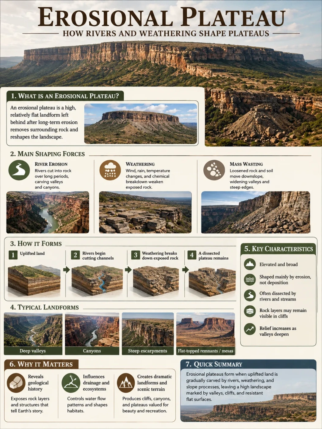
Volcanic Plateau Landform
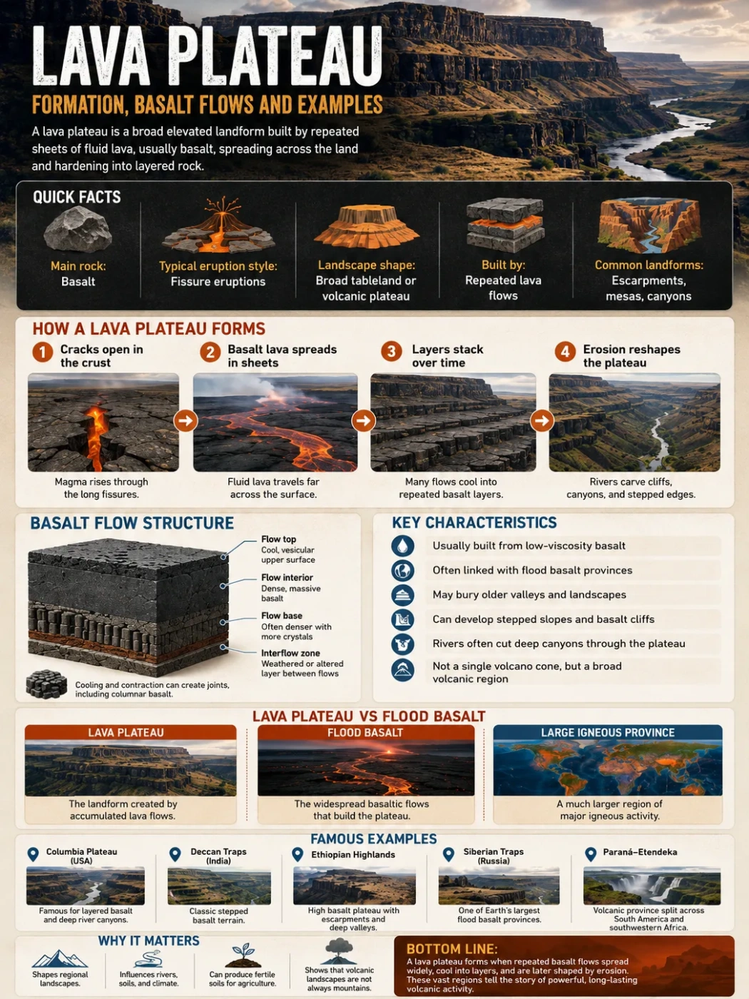
A lava plateau is a broad, raised landform built by repeated sheets of fluid lava, usually basalt, spreading across older ground and hardening into stacked rock layers.
A lava plateau forms when many thin to thick lava flows cover a wide area over time. The surface may look like a plain, a highland, or a stepped tableland, but its inside is layered like a stack of dark volcanic sheets.
Most lava plateaus are linked with basalt flows. Basalt is usually fluid enough to travel far from vents and fissures. Instead of building one tall volcanic cone, the lava spreads outward, fills low ground, buries older valleys, and creates a wide volcanic surface.
Geography Note
A lava plateau is not simply “a flat volcano.” It is usually a region built by many lava flows, often from long cracks in the crust rather than one central cone.
| Feature | Typical Description |
|---|---|
| Main landform type | Volcanic plateau or basaltic tableland |
| Main rock | Basalt, often in repeated lava-flow layers |
| Common eruption style | Low-viscosity lava from fissures, vents, or rift zones |
| Typical surface shape | Broad, gently sloping, sometimes stepped or dissected by rivers |
| Related terms | Flood basalt, trap, volcanic plateau, basalt province, large igneous province |
| Common map clue | Wide volcanic rock area with river canyons, escarpments, mesas, or basalt cliffs |
What Is a Lava Plateau?
A lava plateau is an elevated area formed when lava spreads over the land in repeated flows and cools into solid rock. Over many eruptions, these flows can build a thick, broad platform.
The word plateau points to the landform shape: a raised area with a relatively broad upper surface. The word lava points to the material that built it.
Many lava plateaus are also called basalt plateaus because basalt is the main rock. Some are part of much larger volcanic regions known as large igneous provinces, where huge volumes of magma reached the surface or entered the crust.
Why Basalt Matters
Basalt is usually darker, denser, and more fluid than silica-rich lavas such as rhyolite. Because it flows more easily, it can spread in wide sheets instead of piling up close to a vent.
This is why lava plateaus often look less like classic volcanoes and more like high plains, layered cliffs, or broad uplands cut by rivers.
Simple rule: if the landform was built by repeated, widespread basalt flows and later stands as a raised tableland, it may be described as a lava plateau.
How Lava Plateaus Form
Lava plateaus form through a sequence of eruptions, cooling, burial, uplift, and erosion. The exact story changes from one region to another, but the main pattern is fairly clear.
1. Cracks Open in the Crust
Many lava plateaus begin when magma rises through long cracks called fissures. These cracks may form in areas affected by rifting, crustal stretching, mantle plume activity, or deep regional weakness.
Instead of erupting from a single round crater, lava may pour out along a line. Some fissures can feed flows that travel far across the landscape.
2. Basaltic Lava Spreads in Sheets
Basaltic lava can move across low slopes, valleys, and older rock surfaces. Each flow cools into a layer. Later eruptions cover it with another layer.
Over time, this creates a thick volcanic pile made of many separate flows. In places such as the Columbia River Basalt Group, hundreds of flows are recognized across the region.
3. Older Terrain Gets Buried
A lava plateau often hides an older landscape underneath. Valleys, hills, river channels, and sedimentary basins may be covered by new basalt.
This burial matters because a lava plateau is not always flat because it formed on flat ground. It may be flat or gently rolling because lava smoothed out older relief.
4. Cooling Creates Joints and Layers
As basalt cools, it contracts. This can form cracks known as joints. In many basalt cliffs, these joints appear as columns, often with polygon-like shapes.
The layers also record separate eruptions. A cliff face may show one dark basalt flow over another, divided by weathered zones, soil horizons, or weaker beds.
5. Rivers Cut the Plateau
After lava builds the plateau, erosion begins to reshape it. Rivers cut canyons into the basalt. Weathering opens cracks. Steep edges, mesas, and escarpments may form where harder basalt protects the surface.
A mature lava plateau can look rugged even if it began as wide, sheet-like flows.
Field Note
Layered basalt cliffs are one of the clearest field clues. They show that the plateau was not made in one moment, but by repeated lava flows stacked over time.
Lava Plateau vs Flood Basalt
The terms lava plateau and flood basalt are closely related, but they do not mean exactly the same thing.
| Term | What It Describes | How It Is Used | Example |
|---|---|---|---|
| Lava plateau | The landform created by accumulated lava flows | Used in geography and landform description | Columbia Plateau, Deccan lava plateau |
| Flood basalt | The widespread basaltic lava flows themselves | Used in geology and volcanic process description | Columbia River Basalt Group, Deccan Traps |
| Large igneous province | A very large region of igneous rock formed by major magmatism | Used for large volcanic and intrusive provinces | Siberian Traps, Paraná-Etendeka Province |
A flood basalt province can build a lava plateau. A lava plateau is the landform people see on the surface after lava has cooled, hardened, and been reshaped by erosion.
Why Lava Plateaus Often Have Stepped Edges
Many basalt plateaus show step-like slopes or cliffs. This is where the word trap comes from in names such as Deccan Traps and Siberian Traps. It is linked to stepped topography.
The steps form because basalt layers weather and break in bands. Harder parts resist erosion. Weaker zones wear back more easily. Over time, the plateau edge can look like a staircase of dark rock ledges.
Rivers can deepen this pattern. As they cut through the basalt, they expose layer after layer, making the plateau’s volcanic structure easier to see.
Basalt Flows Inside a Lava Plateau
A lava plateau is not one single slab. It is usually made of many individual basalt flows. Each flow has its own cooling surface, internal cracks, and sometimes a vesicular top where gas bubbles were trapped.
Common Parts of a Basalt Flow
- Flow top: often rough, broken, weathered, or full of small gas holes.
- Flow interior: usually denser and more massive, sometimes with columnar joints.
- Flow base: the contact where lava moved over older ground or an earlier flow.
- Interflow zone: a boundary between flows, sometimes weathered or sediment-filled.
These parts help geologists separate one eruption layer from another. They also help explain why cliffs, road cuts, and canyon walls in basalt plateau regions often show repeated bands.
Landform Note
Basalt can protect a surface from erosion. When softer rock around it wears away, old lava-filled valleys may become ridges or mesas. This is called inverted relief.
Major Lava Plateau Examples
Lava plateaus occur in several parts of the world. Some are still easy to recognize as high tablelands. Others are older volcanic provinces that have been deeply eroded, buried, or broken apart by later tectonic movement.
| Example | Location | Main Countries or Region | Approximate Elevation or Scale | Known For |
|---|---|---|---|---|
| Columbia Plateau | Northwestern North America | United States: Washington, Oregon, Idaho, and nearby areas | Often described as covering about 260,000 square km; elevation varies widely from low river valleys to uplands | Layered Columbia River basalt flows, Columbia and Snake river canyons, scabland terrain |
| Deccan Plateau / Deccan Traps | Western and peninsular India | Mainly Maharashtra and nearby states, within the wider Deccan region | The broader Deccan averages roughly 600 m in elevation, with basaltic lava areas in the northwest | Step-like basalt terrain, broad tableland, major peninsular river systems |
| Ethiopian Highlands | Northeastern Africa | Ethiopia and nearby highland regions | Large areas rise above 2,000 m; some basalt piles are described as thousands of metres thick | High basalt plateau, escarpments, deep river-cut valleys, links with the Afar hotspot region |
| Siberian Traps | Northern Asia | Russia, mainly Siberia | A very large ancient flood basalt province; much of the original surface has been altered by erosion and later geology | One of Earth’s largest basalt provinces, associated with vast lava and intrusive rock volumes |
| Paraná-Etendeka Province | South America and southwestern Africa | Brazil, Uruguay, Paraguay, Argentina, Namibia, and Angola regionally | A large flood basalt province split by the opening of the South Atlantic | Basalt flows linked with continental breakup and matching volcanic rocks on opposite sides of the Atlantic |
Columbia Plateau
The Columbia Plateau is one of the clearest examples of a lava plateau. It covers a large area of the northwestern United States and is strongly linked with the Columbia River Basalt Group.
Its landscape includes basalt cliffs, river gorges, coulees, rolling uplands, and dry steppe-like areas. The Columbia and Snake rivers cut through the plateau and expose thick sequences of basalt flows.
On maps, the region is useful because it shows how a lava plateau can be both broad and deeply dissected. The surface may look open and gently rolling in one area, then suddenly drop into a canyon where rivers have cut into the basalt.
Deccan Lava Plateau
The Deccan is a large plateau region in India, and its northwestern part contains the famous Deccan Traps. These basalt flows form stepped hills, tablelands, and dark rock exposures across parts of western and central India.
The wider Deccan Plateau slopes generally eastward. Major rivers such as the Godavari, Krishna, and Kaveri flow toward the Bay of Bengal, while the Western Ghats form a strong western edge near the Arabian Sea.
The Deccan shows how a lava plateau can be part of a much larger regional landscape. Not every part of the Deccan is the same rock or the same elevation, but basalt flows are one of its best-known geological features.
Ethiopian Highlands
The Ethiopian Highlands include some of Africa’s highest plateau country. Large areas are made of basalt from major flood-like lava eruptions. Later uplift and river erosion cut deep valleys and steep escarpments into the highland surface.
This region is a strong example of how lava, uplift, and erosion work together. The lava built broad volcanic layers, tectonic uplift raised the region, and rivers carved canyons into the plateau margins and interior.
Siberian Traps
The Siberian Traps are often discussed as a flood basalt province rather than a simple modern plateau. The region is very old, and later erosion has changed much of the original volcanic surface.
It still matters in lava plateau study because it shows the scale that basaltic eruptions can reach. The name “traps” also points to the stepped relief that can form where layered basalt is exposed.
How Lava Plateaus Affect Rivers and Basins
Lava plateaus can change drainage patterns. When lava covers older valleys, rivers may be pushed into new courses. Some flows dam streams, fill basins, or force water to cut around resistant basalt.
After the lava cools, rivers begin cutting into it. Basalt is strong, but joints and layer boundaries give water places to work. Over time, rivers can form:
- Canyons where streams cut downward through stacked flows.
- Waterfalls where harder basalt ledges resist erosion.
- Coulees or dry channels in areas shaped by large past floods.
- Escarpments where plateau edges retreat by erosion.
- Basalt-lined valleys where rivers follow weaker zones between flows.
This is why lava plateaus are not just volcanic features. They also help shape river basins, canyon systems, groundwater pathways, and regional soils.
Climate and Soil on Lava Plateaus
The climate of a lava plateau depends on latitude, elevation, rain-shadow effects, and nearby mountains. Lava alone does not create one climate type.
Some basalt plateaus are semiarid, such as large parts of the Columbia Plateau. Others are high, cooler, and wetter in places, such as parts of the Ethiopian Highlands. The Deccan has strong monsoon influence, with wetter western margins and drier interior areas.
Basalt can weather into mineral-rich soils. In some regions, these soils support farming. Drainage, slope, rainfall, and soil depth still matter. A basalt plateau can include fertile plains, rocky uplands, dry grasslands, forested slopes, and deeply eroded badland-like areas.
Careful reading point: a lava plateau’s rock type does not automatically tell its climate. Elevation, wind direction, monsoon patterns, rain shadows, and river systems all affect the landscape.
Lava Plateau vs Similar Landforms
Lava plateaus are often confused with other raised or volcanic landforms. The difference usually comes down to shape, rock type, eruption style, and scale.
| Landform | Main Shape | How It Forms | How It Differs from a Lava Plateau |
|---|---|---|---|
| Shield volcano | Broad volcanic dome | Repeated fluid lava flows from a central or related vent system | Usually centered on a volcano; a lava plateau is more regional and sheet-like |
| Mesa | Flat-topped hill with steep sides | Erosion leaves a resistant caprock over softer layers | A mesa is smaller; it may be carved from a lava plateau but is not the whole plateau |
| Volcanic plain | Broad low-relief volcanic surface | Lava spreads across lowland terrain | May not be high enough or dissected enough to be called a plateau |
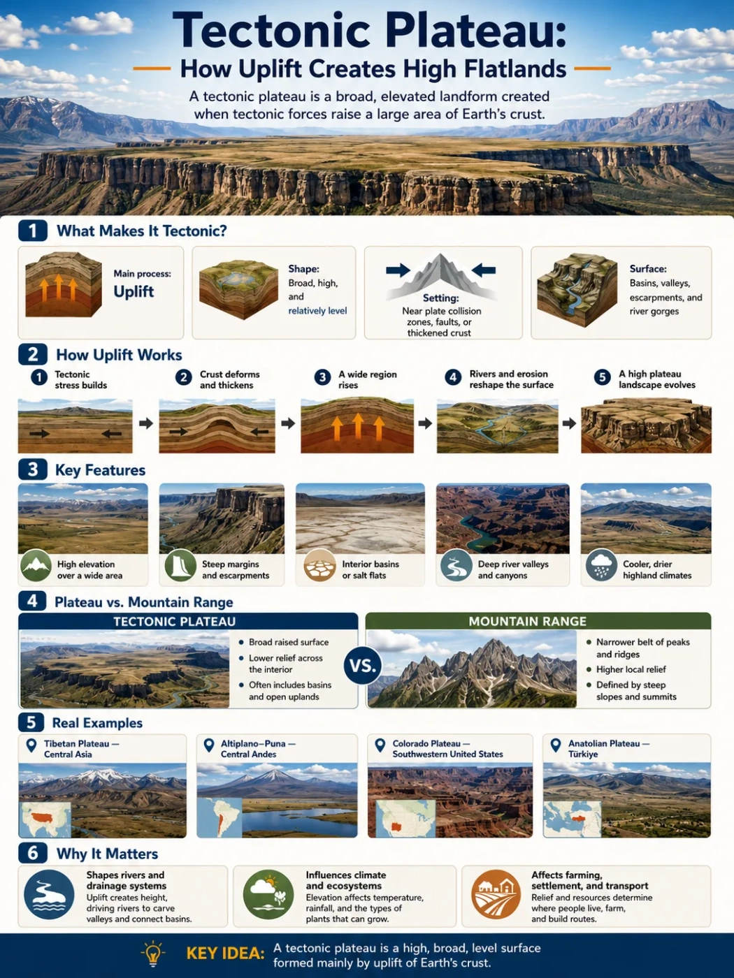
| Tectonic plateau | Large raised region | Crustal uplift, compression, or block movement | Built mainly by tectonic uplift, not by stacked lava flows |
| Pyroclastic plateau | Broad volcanic surface | Ash, tuff, and volcanic fragments settle or flow across the land | Made mostly from explosive volcanic deposits, not fluid basalt sheets |
Common Mix-Up
A lava plateau is not the same as every volcanic plateau. Some volcanic plateaus are built from ash-flow tuffs or other pyroclastic deposits. Lava plateaus are mainly built by lava flows.
How to Recognize a Lava Plateau on a Map
A lava plateau can be hard to identify from a simple political map. Physical maps, geologic maps, elevation data, and satellite images make it clearer.
Look for these clues:
- Large areas marked as basalt, flood basalt, trap, or volcanic rock.
- Broad uplands rather than one isolated cone.
- Rivers cutting deep canyons through layered rock.
- Escarpments or stepped slopes along plateau margins.
- Flat-topped remnants, mesas, or buttes where basalt protects the surface.
- Long fissure zones or dike swarms in geological descriptions.
The best map-reading clue is the combination of wide basalt coverage and plateau-like relief. Basalt alone is not enough. A small lava field is not automatically a lava plateau.
Why Lava Plateaus Matter in Geography
Lava plateaus matter because they connect geology with surface geography. They explain why some regions have wide uplands, dark cliffs, stepped escarpments, canyon systems, and fertile basalt-derived soils.
They also show that not all volcanic landscapes look like cones. Some of Earth’s largest volcanic features are broad regions where lava spread across the land in sheets.
For students, map readers, and geography learners, lava plateaus help connect several ideas at once:
- Elevation: many lava plateaus stand above nearby lowlands.
- Rock type: basalt often controls erosion, cliffs, and soil.
- Drainage: rivers may cut deep canyons through lava layers.
- Climate: elevation and nearby mountains affect rainfall and vegetation.
- Regional identity: many plateau regions shape farming, settlement, roads, and water use.
Mini FAQ
Is a lava plateau the same as a volcanic plateau?
Not always. A lava plateau is a type of volcanic plateau built mainly by lava flows. A volcanic plateau can also form from ash, tuff, or other volcanic deposits.
Why are many lava plateaus made of basalt?
Basaltic lava is usually fluid enough to spread far from fissures or vents. This helps it form wide sheets that can stack into a broad plateau.
Is a lava plateau one giant volcano?
Usually no. Many lava plateaus form from repeated eruptions across fissures or vent systems. The result is a volcanic region, not one simple cone-shaped volcano.
What is the difference between a lava plateau and a flood basalt?
A flood basalt is the widespread basaltic lava flow or group of flows. A lava plateau is the landform created when those flows build a broad raised surface.
Can rivers cut through lava plateaus?
Yes. Rivers can cut deep canyons into basalt layers, especially along joints, cracks, and weaker boundaries between flows. The Columbia and Snake river systems show this clearly in the Columbia Plateau region.
Are lava plateaus always flat?
No. They may begin as broad, low-relief lava surfaces, but erosion, uplift, faulting, and river cutting can create canyons, escarpments, mesas, and rugged highlands.