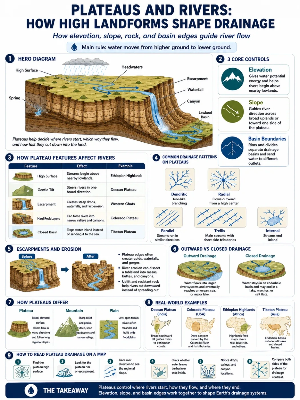
Plateaus shape rivers by lifting broad areas of land above nearby lowlands. Rain, snowmelt, and groundwater leave these high surfaces through channels, valleys, springs, gorges, and drainage basins. A plateau does not simply sit above a river system; it often helps decide where water starts, where it flows, how fast it cuts downward, and which basin receives it.
The main rule is simple: water moves from higher ground toward lower ground. On a plateau, that rule becomes more visible because elevation, slope, rock layers, cliffs, and basin edges all guide the route.
| Plateau Feature | Effect on Rivers | Map Clue | Real-World Example |
|---|---|---|---|
| High Surface | Helps streams begin above nearby lowlands | Short streams flowing away from uplands | Ethiopian Highlands feeding parts of the Nile system |
| Gentle Tilt | Steers rivers toward one side of the plateau | Many rivers flowing in the same broad direction | Deccan Plateau rivers flowing mostly eastward |
| Escarpment | Creates steep drops, waterfalls, and fast erosion | Sharp contour lines near a plateau edge | Western Ghats along the edge of the Deccan Plateau |
| Hard Rock Layers | Can slow erosion or force rivers into narrow valleys | Straight or angular river courses | Colorado Plateau canyon country |
| Closed Basin | Traps water inland instead of sending it to the sea | Rivers ending in lakes, salt flats, or dry basins | Parts of the Tibetan Plateau and Central Asian highlands |
How Plateaus Shape River Drainage
A plateau affects drainage in three main ways: it raises land, creates slopes, and sets boundaries between basins. These three controls help explain why rivers often begin in highlands, cut deep valleys through tablelands, or flow away from a plateau edge in several directions.
In geography, drainage means the way water leaves an area through streams, rivers, lakes, wetlands, groundwater, or dry channels. A drainage basin is the land area that sends water to one outlet, such as a river mouth, lake, bay, or inland depression.
Geography Note: A plateau is not the same thing as a watershed, but it can contain many watershed divides. The highest ridges, rims, and tilted surfaces decide which side of the plateau receives runoff.
On a flat map, a plateau may look calm and simple. On a physical map, it tells a more active story. Rivers mark the weak lines, the steep margins, and the long-term slope of the land.
Short Answer: Why High Landforms Matter for Rivers
High landforms matter because rivers need a height difference to flow. A plateau gives water elevation, and elevation gives rivers energy. That energy helps rivers cut channels, carry sediment, cross rock layers, and form valleys.
The higher and steeper the surface, the more potential energy water has. But height alone is not enough. A dry plateau may have few permanent rivers. A wet plateau with deep soils, springs, or seasonal snow can feed large river systems.
- Elevation helps rivers start and move downslope.
- Slope controls the general direction of flow.
- Rock type affects how fast channels cut down.
- Climate controls how much water reaches the channels.
- Basin shape decides whether water reaches the ocean or stays inland.
Plateaus as River Source Areas
Many rivers begin in highlands because rain, snow, and groundwater collect on elevated terrain. A plateau may act as a broad source area, especially when it receives seasonal rain or lies near mountains that catch moisture.
This does not mean every plateau is wet. Some high plateaus are cold and dry. Others are warm and semi-arid. The river pattern depends on how elevation, climate, and bedrock work together.
Rainfall and Snowmelt on High Surfaces
Plateaus can receive more rainfall than nearby lowlands when moist air rises over high ground. In colder regions, snow can store water for part of the year, then release it during warmer months.
That release may feed streams long after a storm has ended.
Springs and Groundwater Flow
Some plateau rivers begin as springs. Water moves through cracks, porous rock, or buried layers until it reaches a cliff, valley wall, or slope where it can emerge.
This is common where harder rock sits above softer or more permeable layers. The river may look small at first, but steady groundwater can keep it flowing through dry seasons.
Drainage Basins, Divides, and Plateau Rims
A drainage divide is the line that separates one river basin from another. On a plateau, this divide may run along a rim, a low ridge, a volcanic high point, or even a broad surface that is hard to notice from ground level.
Divides do not always look like mountain peaks. On some plateaus, the divide is gentle and wide. Water falling a short distance on one side may enter one river system, while water falling on the other side may travel toward a different sea, lake, or inland basin.
| Term | Plain Meaning | How It Relates to Plateaus |
|---|---|---|
| Drainage Basin | Land that drains to one outlet | A plateau may contain several basins or form part of a much larger one |
| Watershed Divide | Boundary between drainage basins | Often follows plateau rims, high ridges, or tilted upland surfaces |
| Escarpment | Steep slope or cliff-like edge | Can send rivers quickly downslope and create waterfalls or gorges |
| Headwaters | Upper starting area of a river | Often found on high plateaus, mountains, or wet uplands |
| Endorheic Basin | Closed basin with no outlet to the sea | Can form on dry interior plateaus where rivers end in lakes, flats, or marshes |
How Slope Controls River Direction
Plateaus may look flat, but most are not perfectly level. A small tilt over hundreds of kilometers can guide large rivers. This is why map-reading matters: the river direction often reveals the hidden slope of the plateau.
The Deccan Plateau in India is a clear example. Much of the plateau slopes broadly from west to east, so several major rivers, including the Godavari, Krishna, and Kaveri systems, flow toward the Bay of Bengal. The surface may not look steep everywhere, but the long-distance gradient is enough to guide drainage.
Map Note: When many rivers on a plateau flow in the same direction, look for a broad regional tilt. The slope may be too gentle to notice in a photograph, but it can stand out on a drainage map.
When Rivers Flow Away from a Central High
Some plateaus and volcanic uplands send rivers outward from a raised center. This can create a radial drainage pattern, where streams move in several directions like spokes from a hub.
This pattern is more common around domes, volcanic fields, and high central uplands than on perfectly flat tablelands.
When Rivers Flow Along Weak Lines
Rivers do not always take the shortest path. They often follow weak zones in rock: faults, joints, softer layers, old valleys, or eroded seams between harder beds.
On a plateau, these weak lines can create straight valleys, sharp bends, or parallel channels. The river pattern can show the structure of the land below the surface.
Escarpments: Where Plateau Rivers Drop Fast
An escarpment is a steep edge of a plateau or upland. It may form through faulting, erosion, volcanic layering, or the wearing back of softer rock under harder rock.
Escarpments matter because they make rivers change behavior. A stream that moves slowly across a broad plateau surface may suddenly drop through a steep valley. That drop can create rapids, waterfalls, plunge pools, or narrow gorges.
Why Waterfalls Often Appear Near Plateau Edges
Waterfalls form where a river crosses a sudden change in height or rock resistance. Plateau rims can supply both. A river may flow over a hard caprock layer and then cut into softer rock below, causing the edge to retreat over time.
This process helps explain why many plateau margins have stepped valleys rather than smooth slopes.
Escarpments and Short Coastal Rivers
Where a plateau rises close to a coast, rivers may be short and steep on the coastal side. They drop quickly from the highland to the sea. On the inland side, rivers may be longer and gentler because the slope stretches across a wider area.
This contrast can be seen along several highland margins, including parts of the Western Ghats near the Deccan Plateau.
River Erosion on Plateaus
Plateau rivers can cut deeply because they often have height to lose. Over long periods, running water removes rock and sediment, carving valleys into surfaces that once looked much flatter.
The result may be a dissected plateau: a highland cut into ridges, canyons, mesas, buttes, and narrow river corridors.
From Tableland to Canyon Country
A tableland is a broad, flat or gently rolling upland. If rivers cut down through it, the surface becomes divided into smaller uplands. The remaining flat-topped pieces may become mesas or buttes.
The Colorado Plateau is often linked with this kind of river erosion. The Colorado River and its tributaries have cut canyons through layered rock, exposing cliffs, benches, and deeply incised valleys.
Why Some Rivers Cut Down Instead of Spreading Out
Rivers cut downward when they have enough energy, when base level drops, or when land is uplifted. A plateau that rises through tectonic uplift may give existing rivers new cutting force. The river then deepens its valley instead of simply moving across a floodplain.
This is why some plateau rivers appear “sunken” into the land. They are not sitting on top of the plateau in a shallow groove; they have cut into it.
Common Drainage Patterns on Plateaus
Drainage patterns are the shapes river networks make on a map. They help show slope, rock structure, and landform type. Plateaus can show several patterns, depending on how they formed and how much erosion has changed them.
| Drainage Pattern | What It Looks Like | What It Often Suggests | Plateau Connection |
|---|---|---|---|
| Dendritic | Tree-like branching | Fairly even rock resistance | Common on broad plateau surfaces with similar bedrock |
| Radial | Streams flowing outward from a high center | Dome, volcano, or central uplift | May appear on volcanic plateaus or domed uplands |
| Parallel | Streams running in similar directions | Strong slope or elongated landform | Can form on tilted plateau margins or steep escarpments |
| Trellis | Main streams with short side tributaries | Alternating hard and soft rock layers | May appear where a dissected plateau has folded or layered rock |
| Internal | Streams ending inland | Closed basin or dry interior | Common in some arid high plateaus and basin-and-range landscapes |
Closed Drainage on High Plateaus
Not all rivers reach the sea. In some plateau regions, water flows into an inland basin and stops there. It may collect in a lake, evaporate from a salt flat, sink into sediment, or spread into wetlands.
This is called internal drainage or endorheic drainage. It often occurs where high land surrounds a basin and the climate is dry enough that evaporation can remove much of the water.
Why Dry Plateaus Often Have Interior Basins
Dry plateaus may receive limited rainfall, and their rivers may lose water before reaching a distant outlet. Evaporation, porous sediment, irrigation, seasonal flow, and basin shape can all reduce surface flow.
On maps, these rivers may appear to fade into lakes, marshes, playas, or salt-covered flats.
Why Internal Drainage Matters
Closed drainage changes soil, water chemistry, and human settlement patterns. Minerals carried by streams may stay inside the basin. Over time, this can help form salty lakes or dry flats.
For people, such basins can be useful but delicate water areas. Springs, seasonal streams, and groundwater may support towns, grazing, farming, or travel routes in otherwise dry highlands.
Plateaus, Rivers, and Climate
Climate decides whether a plateau has permanent rivers, seasonal streams, or mostly dry channels. Elevation can cool the air, but it does not guarantee rainfall. The position of the plateau, nearby seas, mountains, winds, and rain shadows all matter.
A wet plateau can feed dense river networks. A dry plateau may have wide valleys that carry water only after storms or during snowmelt.
Wet Plateaus
Wet plateaus often have more streams, deeper soils, and more continuous river flow. Where rainfall is regular, rivers can cut valleys steadily and carry sediment throughout much of the year.
Dry Plateaus
Dry plateaus may show dramatic channels even when water is rare. Short, intense storms can carve gullies, washes, and canyons. The channel may stay dry for long periods, then carry fast-moving water after heavy rain.
Cold High Plateaus
Cold plateaus may store water as snow, ice, or frozen ground. Rivers may rise during thaw seasons. In some high regions, meltwater creates short but strong seasonal flow.
Elevation Note: A high plateau can be dry if it lies in a rain shadow. Elevation shapes drainage, but climate decides how much water is available for rivers to carry.
How Plateaus Differ from Mountains in River Drainage
Mountains and plateaus can both feed rivers, but they do not shape drainage in the same way. Mountains often create steep, narrow headwater zones. Plateaus usually provide broader surfaces where streams can organize before cutting down toward lower land.
| Feature | Plateau | Mountain |
|---|---|---|
| General Shape | Broad elevated surface, often flat or gently rolling | Steep, high relief terrain with peaks and ridges |
| River Start Areas | May begin across wide uplands, springs, or plateau rims | Often begin in steep headwater valleys, snowfields, or glaciers |
| Drainage Style | Can show wide basin control and long tilted flow | Often shows sharp divides and short steep tributaries |
| Erosion Form | Canyons, mesas, dissected tablelands, escarpment valleys | V-shaped valleys, ravines, cirques in glaciated areas |
A simple memory rule helps: mountains focus drainage from sharp highs, while plateaus spread drainage across broad highs.
How Plateaus Differ from Plains in Drainage
Plains and plateaus can both look broad and open, but their elevation and edges create different river behavior. A plain is usually lower and has gentler relief. A plateau stands higher than nearby land and may end at a clear rim or escarpment.
On plains, rivers often meander, build floodplains, and shift across softer sediment. On plateaus, rivers are more likely to cut down into bedrock, form entrenched valleys, or drop from upland edges.
Why the Difference Matters on Maps
If a river crosses a plain, look for wide bends, floodplains, oxbow lakes, and low gradients. If it crosses a plateau, look for steep-sided valleys, contour lines packed near channels, and sudden drops near escarpments.
The landform changes the river’s job. On a plain, the river often spreads and deposits. On a plateau, it often cuts and carries material away.
Examples of Plateaus That Shape River Systems
Different plateaus affect drainage in different ways. The examples below show why one rule cannot explain every highland river system.
Deccan Plateau
The Deccan Plateau covers a large part of peninsular India. Its broad surface tilts mainly eastward, so several major rivers flow from the Western Ghats across the plateau toward the Bay of Bengal.
This is a strong example of slope-controlled drainage. The rivers do not only reflect rainfall; they also show the long tilt of the land.
Colorado Plateau
The Colorado Plateau in the southwestern United States is known for deep river incision through layered rock. The Colorado River and its tributaries have carved canyons, exposing rock layers and shaping a dissected plateau landscape.
Here, river drainage is closely tied to uplift, bedrock, and long-term erosion.
Ethiopian Highlands
The Ethiopian Highlands are often described as a high plateau and mountain region. They feed important river systems, including tributaries connected with the Nile basin.
This area shows how high elevation, seasonal rainfall, and steep margins can support large drainage networks.
Tibetan Plateau
The Tibetan Plateau is one of Earth’s highest and broadest uplands. It connects with the headwaters of several large Asian river systems, while some interior areas have closed basins and lakes.
This contrast makes it useful for understanding both outward drainage and internal drainage on high plateaus.
Simple Map-Reading Guide for Plateau Drainage
A physical map can reveal how a plateau controls rivers. Start with elevation, then trace the water paths.
- Find the high surface. Look for broad elevated areas rather than narrow peaks.
- Look for the rim. Escarpments often appear as sharp contour changes.
- Trace the river direction. Rivers usually show the regional slope.
- Check the outlet. Does the water reach a sea, a lake, or an inland basin?
- Notice valley depth. Deep narrow valleys suggest strong downward erosion.
- Compare both sides of the plateau. One side may have short steep streams, while the other has long gentle rivers.
This approach works even without a special geology map. Rivers are often the easiest way to read the hidden shape of a plateau.
Common Mix-Ups About Plateaus and Rivers
A Plateau Is Not Always Flat
Many plateaus are only flat in a broad sense. They may include hills, valleys, mesas, canyons, lava fields, basins, and escarpments.
A High Plateau Does Not Always Have Big Rivers
Big rivers need water supply as well as elevation. A dry high plateau may have small seasonal streams, while a wetter lower plateau may support larger rivers.
A River Canyon Does Not Mean the Land Is a Mountain Range
Deep canyons can cut through plateau country. The land may still be a plateau if the wider surface remains elevated and relatively broad.
Not Every Plateau River Starts on the Plateau
Some rivers cross a plateau after beginning in mountains or another highland area. In that case, the plateau may shape the river’s valley and erosion, even if it is not the river’s source.
Why Plateaus Matter in Human Geography
Plateau drainage affects where people can farm, build roads, settle, and find water. Rivers on plateaus may support irrigation, towns, grazing areas, and transport corridors, especially where water is limited.
Valleys cut into plateaus can also create natural routes through otherwise high or rugged terrain. Springs along escarpments may become local water points. In dry regions, a small reliable stream can shape settlement more than a wide empty upland.
Plateau rivers also affect soil. Floodplains, terraces, and valley bottoms can hold deeper sediment than surrounding rocky uplands. This makes some river corridors far more useful for farming than the plateau surface above them.
Mini FAQ
How do plateaus affect river drainage?
Plateaus affect river drainage by raising land above nearby areas, creating slopes, forming drainage divides, and giving rivers energy to cut valleys. Their rims, rock layers, and basin shapes help decide where streams flow and whether they reach the sea or end inland.
Do rivers usually start on plateaus?
Some rivers start on plateaus, especially where high surfaces receive rain, snowmelt, or groundwater flow. Other rivers begin in mountains and later cross a plateau, where they may cut canyons or follow older valleys.
Why do rivers cut deep canyons into some plateaus?
Rivers cut deep canyons into plateaus when they have enough elevation, flowing water, and time to erode downward. Uplift, resistant rock layers, and a lower outlet can make the river deepen its channel instead of spreading across a wide floodplain.
Can a plateau have no rivers?
A plateau can have few or no permanent rivers if the climate is very dry, if water sinks into porous ground, or if streams flow only after storms. Some dry plateaus have seasonal channels rather than year-round rivers.
What is the difference between a drainage basin and a plateau?
A plateau is an elevated landform. A drainage basin is an area of land where water flows toward one outlet. A plateau can contain several drainage basins, and a drainage basin can include plateaus, mountains, plains, and valleys.