Spain · Meseta Central
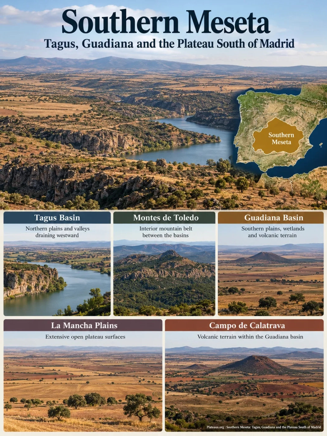
The Southern Meseta, also called the Submeseta Sur or Southern Subplateau, is the generally lower southern half of Spain’s Meseta Central. It is not one flat tableland: the Tagus and Guadiana basins, the Montes de Toledo, the plains of La Mancha, the volcanic terrain of Campo de Calatrava, and older erosion surfaces farther west all belong to the same broad elevated interior.
Tagus and Guadiana drainage
Basin surfaces often about 500–700 m
What the Southern Meseta Actually Covers
The Sistema Central divides the Meseta Central into northern and southern subplateaus. South of that mountain belt, the Southern Meseta spreads across much of central-southern Spain. Its most recognizable surfaces lie in Madrid, Castilla-La Mancha and eastern Extremadura, but its physical limits do not follow autonomous-community or provincial boundaries.
To the north, the Sistema Central forms the clearest break with the Northern Meseta. The Sistema Ibérico frames much of the eastern side, while Sierra Morena marks the southern rim over a long distance. The western transition is less abrupt because old erosion surfaces descend toward western Iberia rather than ending at a single sharp escarpment.
Name and Boundary Note
Southern Meseta is a physical-geography term, not an administrative region. It is not another name for Castilla-La Mancha, and La Mancha is only one major landscape within it. Madrid’s low-relief interior, the Tagus basin, parts of Extremadura, the Montes de Toledo and Campo de Calatrava also belong to the wider physiographic story.
Elevation Note
Elevation figures depend on what is being measured. Spain’s National Geographic Institute gives about 650 m as the mean height of the Meseta Central as a whole, while its educational relief mapping places the southern sedimentary basins mainly around 500–700 m. Those numbers should not be treated as one exact average for every definition of the Southern Meseta, because mountain ridges and eastern uplands rise well above the basin floors.
Two Great River Basins Are Split by an Interior Mountain Belt
The Southern Meseta is easier to understand as a high interior divided into two large drainage domains. The Tagus basin occupies the northern side and the Guadiana basin the southern side. Between them, the Montes de Toledo form a long internal watershed.
Northern mountain divide separating the Southern and Northern Mesetas
Northern sedimentary and erosional surfaces draining westward
Internal ridge system dividing Tagus and Guadiana drainage
Southern plains, carbonate terrain, wetlands and volcanic sectors
Major southern rim of the Meseta Central
The Tagus Side Is Not One Simple Trough
The northern part of the Southern Meseta contains the large Cenozoic Tagus foreland basin, but even this basin is internally varied. In the central-eastern sector, the Sierra de Altomira separates the Madrid and Loranca sub-basins. Geological mapping places maximum Cenozoic sediment thickness at roughly 3.5 km in the Madrid sub-basin near the Sistema Central and about 1.4 km in the Loranca sub-basin.
That thickness records prolonged basin subsidence and sediment supply from surrounding uplifts. The modern surface may look subdued, yet several kilometres of younger continental sediment can sit above the much older Iberian basement.
The Guadiana Side Has Flatter Plains and More Complex Groundwater
South of the Montes de Toledo, wide low-gradient surfaces become especially prominent across La Mancha and the upper Guadiana country. Carbonate rocks, basin sediments and shallow gradients allow surface drainage and groundwater to interact closely. This helps explain why parts of the Southern Meseta contain springs, seasonal wetlands and areas of semi-endorheic drainage even though the Guadiana ultimately flows west to the Atlantic.
Ancient Basement and Younger Basins Built the Present Landscape
The Southern Meseta combines very old rocks with much younger basin fills. Its deepest structural foundation belongs to the Iberian Massif, assembled during the Paleozoic Variscan, or Hercynian, orogeny. Long periods of erosion then lowered and smoothed much of that old mountain terrain.
Variscan Mountain Building Creates the Basement
Compression formed and deformed the rocks of the Iberian Massif. Quartzites, slates and other Paleozoic rocks exposed in the Montes de Toledo and western sectors belong to this older structural foundation.
Marine and Continental Sediments Accumulate in the East
As Iberian tectonics changed, Triassic, Jurassic and Cretaceous sediments were deposited over parts of the older basement. Carbonate successions are especially relevant in areas such as Campo de Montiel and the eastern margin near the Sistema Ibérico.
Alpine Compression Reactivates the Interior
Uplift and reactivation of surrounding mountain systems created relief around subsiding interior basins. Rivers and alluvial systems carried sediment from those rising margins into the Tagus and Guadiana depressions, progressively filling them.
Erosion, River Incision and Volcanism Add New Landforms
Differential erosion shaped ridges, cuestas, isolated hills and broad plains, while Campo de Calatrava added volcanic cones, lava flows and maar depressions to the older plateau surface.
This history explains why the word plateau does not imply one rock type or one age. The present elevated surface is a composite of inherited basement, tectonically formed basins, sediment infill, erosional remnants and local volcanic construction.
Montes de Toledo: Mountains Inside the Plateau
The Montes de Toledo are not an outer wall of the Southern Meseta. They lie inside it and divide the Tagus and Guadiana drainage systems. Their ridges expose Paleozoic rocks that behaved differently under erosion, especially resistant quartzites alternating with less resistant slates and related rocks.
This contrast produces Appalachian-style relief: long, narrow quartzite ridges persist while weaker bands are worn into elongated depressions. The landscape therefore forms a striped pattern of ridges and lower corridors rather than a single massive mountain block.
At the foot of these ridges, coarse deposits known as rañas spread across piedmont surfaces. They commonly contain angular or subangular quartzite clasts carried away from the uplands and laid over gentler ground. Rañas are useful markers of the way erosion linked the interior mountains to the surrounding basin margins.
Hard rock survives as narrow ridges and crests.
Faster erosion opens parallel valleys and depressions.
Coarse quartzite-rich debris spreads outward as raña surfaces.
La Mancha Is a High Plain, Not a Lowland Basin at Sea Level
La Mancha creates one of the Southern Meseta’s most familiar visual impressions: long horizons, very low local relief and broad agricultural surfaces. Its flatness can be misleading. Much of the plain still stands hundreds of metres above sea level because it occupies an elevated interior basin within the Meseta Central.
The subdued surface reflects both basin filling and erosion. Cenozoic limestones, marls, clays and other continental sediments cover large areas. Where resistant limestone caps remain, they protect higher flat surfaces; where softer materials are exposed, erosion opens lower rolling plains.
Páramos, Cuestas, Campiñas and Cerros Testigo
Four landform terms help explain the stepped and patchy relief of the sedimentary parts of the Southern Meseta.
Páramos
Relatively high, level surfaces protected by resistant limestone or other hard caprock.
Cuestas
Sloping transitions where resistant beds and softer underlying strata are exposed along an eroded margin.
Campiñas
Lower, gently rolling plains developed mainly on softer sediments after the higher caprock has been removed.
Cerros Testigo
Isolated residual hills that preserve a remnant of a formerly more extensive resistant surface.
Landform Terminology
The Spanish geomorphic term páramo in this setting refers to a high, often limestone-capped tableland or structural surface. It should not be confused with the humid tropical alpine páramo ecosystem of the northern Andes.
The Southern Meseta Changes Markedly from East to West
The plateau is generally higher toward the east and tilts westward toward Atlantic drainage. The Tagus and Guadiana reflect that broad gradient in their west-flowing courses. Across the land surface, the change is not a smooth ramp; different rock belts and basins create distinct terrain zones.
| Sector or Landform | Main Geological Control | Typical Surface Expression | Geographic Role |
|---|---|---|---|
| Tagus sedimentary basin | Cenozoic continental basin fill over older basement | Páramos, cuestas, campiñas and river valleys | Drains the northern part of the Southern Meseta westward |
| La Mancha plain | Broad sedimentary surfaces with carbonate, marl and clay | Very low local relief and open horizons | Forms one of the broadest continuous plain-like landscapes within the southern subplateau |
| Montes de Toledo | Paleozoic quartzite and slate belts | Parallel resistant ridges, depressions and raña piedmonts | Separates Tagus and Guadiana drainage |
| Campo de Montiel | Mainly Mesozoic carbonate rocks | Limestone uplands, karst and travertine-related landforms | Forms a distinctive southeastern highland sector linked to upper Guadiana drainage |
| Campo de Calatrava | Paleozoic basement and basin sediments overprinted by volcanism | Scoria cones, maars, lava surfaces and volcanic depressions | Adds a volcanic landscape to the central-southern plateau |
| Western peneplain sectors | Long-eroded Iberian Massif basement | Broad rolling erosion surfaces with low residual relief | Marks the transition toward western Iberian and Atlantic-facing terrain |
Campo de Montiel is a useful reminder that the eastern Southern Meseta is not simply an extension of the La Mancha plain. Its Mesozoic carbonate rocks support karstic drainage and the travertine-barrier landscape of the Ruidera Lakes, adding another surface type within the wider plateau system.
Campo de Calatrava Adds a Volcanic Field to the Plateau
Near Ciudad Real, the Campo de Calatrava Volcanic Field interrupts the expected pattern of sedimentary plains and Paleozoic ridges. It is a monogenetic volcanic field, meaning that many individual vents produced relatively small volcanic edifices rather than building one dominant long-lived stratovolcano.
mapped volcanic centres or edifices in widely used inventories
approximate area covered by the volcanic field
Calatrava Volcanoes–Ciudad Real entered the UNESCO Global Geopark network
Published inventories do not all use the same mapping threshold. Some count more than 360 volcanic edifices, while broader reference catalogues describe more than 300. The difference is best understood as a mapping and classification issue rather than a contradiction about the existence of the field.
Scoria Cones, Lava Flows and Maars Record Different Eruption Styles
Low-volume basaltic and related magmas produced scoria and spatter cones as well as lava flows. Where rising magma interacted explosively with groundwater, phreatomagmatic eruptions excavated maars—broad crater depressions that may later hold lakes, wetlands or sediment-filled basins.
Campo de Calatrava is especially useful for studying how the same eruptive process produces different crater shapes in different substrates. Researchers distinguish many maars excavated into hard Paleozoic basement from those formed in softer, water-saturated Neogene sediments.
Hard-Substrate Maars
- Excavated into jointed Paleozoic rock such as quartzite, slate and related basement.
- Commonly form more sharply defined or funnel-like crater basins.
- Crater rims and structural form tend to preserve more clearly.
Soft-Substrate Maars
- Excavated into unconsolidated or weak Neogene basin sediments.
- Often broader and shallower, with bowl-like geometry.
- Erosion and subsidence can blur rims or merge neighbouring depressions.
Volcanic-Age Caution
The youngest Campo de Calatrava activity is not described identically in every chronology. Most of the field is Pliocene to Pleistocene in age, while a widely used global volcanic catalogue retains a mid-Holocene date for late phreatomagmatic activity at Columba. An exact “last eruption” date should therefore be presented with its dating context rather than as an uncontested single number.
The Calatrava Volcanoes–Ciudad Real UNESCO Global Geopark designation in 2024 gives international recognition to this volcanic and geological heritage. The geopark covers a defined territory in Ciudad Real; it is not another name for the Southern Meseta as a whole.
The Upper Guadiana Is Also a Groundwater Landscape
Low gradients alone do not explain the southern basin. Across parts of La Mancha, carbonate rocks allow water to infiltrate, move through aquifers and return to the surface at springs. The historical Ojos del Guadiana are the best-known example of these groundwater emergence points.
Las Tablas de Daimiel shows how the plateau’s surface and subsurface drainage can meet. The wetland occupies very low-gradient terrain near the confluence of the Guadiana and Gigüela systems and combines floodplain inundation with groundwater discharge. Local terms such as ojos and ojillos refer to places where the water table reaches the surface.
Water enters permeable carbonate terrain and basin sediments.
Groundwater moves through fractured and karstified rock beneath the La Mancha surface.
Where the water table intersects the land surface, groundwater can reappear and feed channels or wet ground.
At Las Tablas de Daimiel, river flooding and groundwater discharge can combine across an exceptionally low-gradient floodplain.
Why the Water Balance Is Sensitive
The central La Mancha plain has a continental Mediterranean climate: summers are hot and dry, winters can be cold, and rainfall varies strongly from year to year. Monitoring at Las Tablas de Daimiel places local annual precipitation around 400 mm, a useful example of the dry central plain but not a value that should be applied to the entire Southern Meseta.
High summer evaporation, drought and groundwater extraction for agriculture can all reduce the water available to springs and wetlands. This is why a plateau that often appears dry at the surface can still have a geography strongly controlled by aquifer levels.
Why Flat Farmland and Elevated Relief Coexist
The Southern Meseta’s broad agricultural landscapes follow its geomorphology. Low-gradient sedimentary surfaces make large fields possible across La Mancha and parts of the Tagus basin, while harder basement ridges and volcanic terrain break that pattern into smaller, more irregular units.
Dryland cereals, vineyards and other Mediterranean crops occupy wide areas where summer moisture is limited. Irrigated farming becomes more important where groundwater or managed surface water is available. The same aquifers that support irrigation also connect land use directly to the hydrology of the upper Guadiana and its wetlands.
Farther west, thinner soils over older siliceous basement and more rolling relief produce a different mosaic, with open woodland, grazing and mixed agricultural land becoming more common. The change from La Mancha to western peneplain terrain is therefore visible not only in rock and slope but also in field pattern and vegetation structure.
Southern Meseta and Northern Meseta Differ in Structure, Not Just Latitude
The Sistema Central separates two parts of the Meseta that have different basin geometry and typical elevations. The southern half is generally lower and more internally divided.
Southern Meseta
- Southern basin surfaces commonly around 500–700 m.
- Drainage divided mainly between the Tagus and Guadiana.
- Montes de Toledo form an internal mountain and watershed belt.
- Contains the broad La Mancha plain and Campo de Calatrava volcanic field.
- Shows a marked transition from eastern sedimentary and carbonate surfaces to western basement peneplains.
Northern Meseta
- Duero basin surfaces are commonly around 800–850 m in Spanish relief mapping.
- Drainage is organized much more strongly around one large basin, the Duero.
- No comparable interior mountain belt divides it into two large river-basin halves.
- Its basin floor is generally higher than the major sedimentary surfaces south of the Sistema Central.
- It lacks an equivalent large monogenetic volcanic field within the basin interior.