INTERACTIVE CONTEXT MAP
Where is Ahaggar Plateau?
The selected plateau and nearby mapped locations are shown. Open the full world atlas to explore every region.
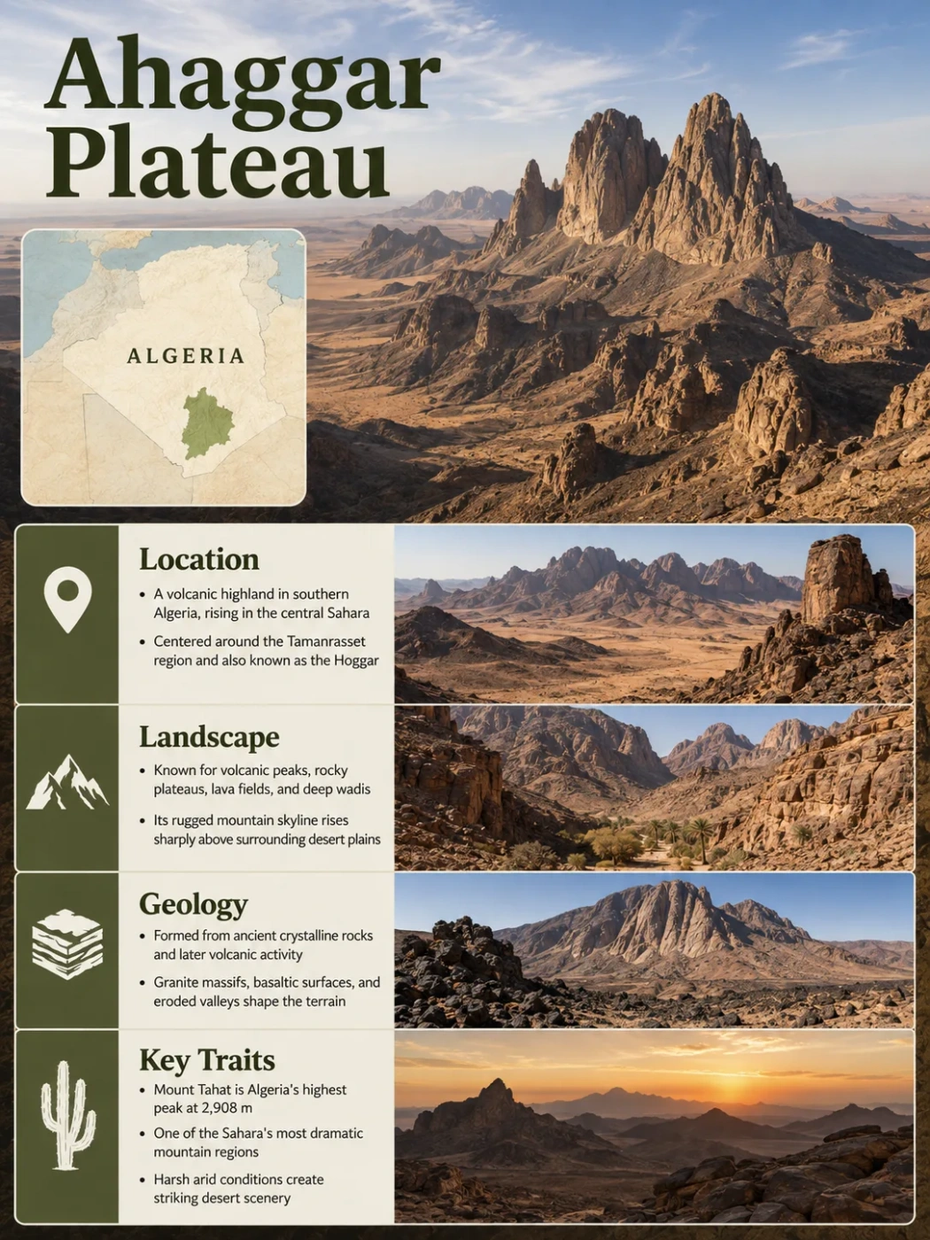
The Ahaggar, also known as the Hoggar, rises from the central Sahara of southern Algeria as a broad but deeply broken highland. Although it is often called the Ahaggar Plateau, its central landscape is far from a flat tableland: ancient crystalline rocks, volcanic fields, exposed volcanic necks, steep ridges and high peaks combine to form one of the Sahara’s major mountain-plateau regions.
Why the Ahaggar Is a Mountain Plateau Rather Than a Flat Tableland
The word plateau can give the wrong first impression of the Ahaggar. At regional scale, the area forms a large elevated part of the Sahara. At local scale, however, much of its central terrain is mountainous and strongly dissected. Mount Tahat reaches about 2,908 metres above sea level and is the highest point in Algeria.
This combination of broad regional elevation and rugged local relief explains why the same area is described as the Ahaggar Plateau, Hoggar Mountains, Ahaggar massif or simply the Hoggar highlands. For landform classification, highland region is particularly useful because it does not imply that the surface remains broadly level across the whole area. Plateaus.org likewise separates Ahaggar/Hoggar from classic plateaus and identifies it as a volcanic and crystalline highland with strongly dissected relief.
Landform Note
Mount Tahat’s 2,908-metre elevation is a summit height, not the average elevation of the Ahaggar. The region contains high mountain sectors, lower rocky surfaces, depressions, wadis and peripheral plateaus at very different elevations.
The Ahaggar Is Built Around the Atakor High Massif
The Ahaggar lies around Tamanrasset in southern Algeria, well inside the Sahara rather than along the Atlas mountain belt of northern Algeria. The most elevated and visually distinctive part is the Atakor, the central massif containing Mount Tahat and extensive volcanic terrain. Tamanrasset lies south of this high core and provides a useful geographic reference point for understanding the region.
The regional structure is more complex than a single mountain block. The high central Atakor is associated with a broader crystalline massif. Lower terrain surrounds parts of this core, while sandstone uplands known as tassilis occur around the wider system. To the north, the crystalline Tefedest Massif extends the Ahaggar highland pattern beyond the Atakor itself.
The highest volcanic and mountainous part of the Ahaggar, including the Mount Tahat area.
Rocky depressions, wadis and lower desert surfaces separate parts of the central massif from surrounding uplands.
Crystalline massifs and sandstone plateau landscapes extend the physical system beyond the central volcanic highlands.
Ancient Crystalline Crust Lies Beneath the Volcanic Landscape
The dark volcanic scenery of the Atakor can make the Ahaggar look like a landscape built entirely by relatively young eruptions. Its geological foundation is much older. Large parts of the Hoggar expose Precambrian metamorphic and plutonic rocks of the Tuareg Shield, an old section of continental crust that extends beyond southern Algeria into neighbouring parts of the central Sahara.
The Tuareg Shield was assembled through a long sequence of crustal collisions, terrane accretion and deformation associated with the Pan-African Orogeny, especially between roughly 750 and 550 million years ago. Major north-south shear zones created during that history remain important structural features of the Hoggar crust.
Much later, the region experienced renewed uplift and intraplate magmatism. Cenozoic volcanism spread across several parts of the Hoggar and added lava flows, cones, domes and volcanic intrusions to the older crystalline foundation. The result is not simply a volcanic plateau laid over a uniform surface, but a composite highland in which ancient crust and younger volcanic landforms overlap.
Metamorphic and plutonic rocks formed and were assembled within the Tuareg Shield.
Older crustal structures were affected by later tectonic and magmatic activity.
Lava, cones, domes and intrusive bodies developed across several volcanic fields.
Long erosion removed weaker material and helped expose resistant volcanic and crystalline forms.
Atakor Is a Volcanic Field, Not a Single Volcano
The Atakor is the largest volcanic field in the Hoggar volcanic province. It covers about 2,150 square kilometres and contains abundant basaltic to basanitic scoria cones and lava flows together with older trachytic and phonolitic domes and volcanic necks.
That distinction matters. The sharp peaks seen across the central Ahaggar are not the flanks of one enormous volcano. The terrain records repeated eruptions from many vents, combined with intrusive activity and later erosion. Some resistant volcanic necks now stand prominently because material that once surrounded them has been removed.
| Landform | What It Represents | Effect on the Landscape |
|---|---|---|
| Scoria cones | Small volcanic cones built around individual eruptive vents | Create numerous separate hills rather than one continuous volcanic summit |
| Lava flows | Basaltic and related lava spreading outward from vents | Cover older surfaces and can occupy valleys or form rocky lava fields |
| Lava domes | More viscous magma accumulated close to a vent | Forms resistant rounded or steep volcanic masses |
| Volcanic necks | Solidified magma within former volcanic conduits | Can remain as isolated steep rock towers after surrounding material erodes |
Atakor is also only part of the wider volcanic province. The Manzaz volcanic field lies to its north and covers about 1,500 square kilometres, while the Tahalra field southwest of Tamanrasset covers roughly 1,800 square kilometres. Both overlie Precambrian rocks of the Tuareg Shield. This wider distribution shows that volcanism affected the Hoggar on a regional scale rather than only at its highest summit area.
How Recent Was Volcanic Activity?
The eruption history requires careful wording. The Smithsonian Global Volcanism Program lists the last known eruption of the Atakor volcanic field as unknown, with credible evidence rather than assigning it a confirmed historical eruption date. Its geological summary reports lava above lake deposits dated to about 10,000 years before present, lava associated with terraces containing Neolithic material, pottery found within lava in the Tahifet area and Tuareg oral traditions that may preserve memories of eruptions.
Nearby Hoggar volcanic fields provide clearer evidence of very young volcanism. Manzaz contains volcanoes resting on Neolithic terraces and is classified as having Holocene activity, while the youngest phase at Tahalra also extends into the Holocene. The safest interpretation is therefore that young volcanism is well established in the wider Hoggar province, while the exact age of Atakor’s latest eruption remains less certain.
Erosion Turned the Volcanic Massif Into a Sharply Dissected Highland
Volcanism alone does not explain the present shape of the Ahaggar. Once volcanic and crystalline rocks were exposed at the surface, long periods of weathering and erosion began separating stronger rock from weaker material.
Water remains an effective erosional agent even in an extremely dry climate. Rainfall is infrequent, but runoff can become concentrated in wadis and steep channels when it does occur. Repeated flash runoff removes weathered material, cuts into slopes and transports sediment away from the mountain core. Temperature changes and mechanical weathering also help break exposed rock.
Differential erosion gradually emphasizes contrasts between rock types. Resistant intrusions, lava masses and volcanic conduits may remain standing while softer surrounding material is lowered. This process helps explain why the Ahaggar contains isolated pinnacles, steep ridges and exposed volcanic necks even though the wider region still forms an elevated Saharan highland.
Reading the Landscape
A steep rock tower in the Ahaggar is not necessarily the original cone of a volcano. In some places, erosion has stripped away much of the former volcanic structure and exposed resistant rock that once solidified inside it.
Altitude Changes the Climate Within the Central Sahara
The Ahaggar occupies one of the driest parts of Africa, but elevation prevents its climate from being uniform. Conditions on the highest ridges differ from those on the lower desert surfaces surrounding them.
Research on the central Saharan highlands describes a steep precipitation gradient with altitude. Annual rainfall is generally below about 25 millimetres at elevations under 1,000 metres, while the highest zone above roughly 2,700 metres can receive around 150–200 millimetres. The totals are still low by humid-region standards, but the difference is large enough to affect runoff, vegetation and habitat availability.
Lower Saharan Terrain
- Extreme aridity dominates.
- Rainfall can remain below 25 mm per year at lower elevations.
- Vegetation is highly sparse away from favourable drainage sites.
- High temperatures and evaporation strongly limit surface water.
Highest Ahaggar Terrain
- Temperatures decrease with elevation.
- Annual precipitation can approach 150–200 mm in the highest zone.
- Cooler and locally wetter conditions support mountain refuges.
- Runoff can feed wadis, pools and gueltas below the high ground.
The mountains can receive rainfall when moist air reaches the central Sahara and is lifted over the high terrain. Rainfall remains irregular, so the Ahaggar should not be treated as a reliably wet mountain system. The importance of elevation lies in the relative change it creates inside an otherwise hyper-arid regional setting.
Wadis and Gueltas Concentrate Water in an Extremely Dry Landscape
The Ahaggar does not support a large permanent river network comparable with humid mountain regions. Drainage is dominated by wadis, channels that may remain dry for long periods but can carry runoff after rainfall.
Where bedrock form, channel shape and local groundwater conditions allow water to persist, the Ahaggar also contains gueltas: natural pools or sequences of pools held within rocky desert drainage systems. These small water bodies are disproportionately important because permanent surface water is scarce across the surrounding Sahara.
Gueltates Afilal
Gueltates Afilal provides a clear example of this relationship between high relief and local water storage. The Ramsar-listed wetland in the Tamanrasset region covers 20,900 hectares and has been designated as a Wetland of International Importance since 2003. Its system includes small terraces, pools and cascades where water can persist in a fully desert environment.
The site supports perennial vegetation and aquatic life, including desert-adapted fish. Plants recorded from the wetland include Olea laperrinei, the Saharan olive, a species associated with isolated highland refuges in the central Sahara.
Irregular precipitation reaches slopes and exposed mountain surfaces.
Steep relief concentrates water into channels instead of allowing it to spread evenly across the desert.
Suitable bedrock forms and local hydrology allow water to remain in gueltas after surrounding surfaces dry.
Water, shade and cooler microclimates support organisms that cannot occupy the open desert as easily.
The Ahaggar Functions as a Biological Island Within the Sahara
Elevation, cooler temperatures and scattered water sources allow the Ahaggar to support habitats that are isolated from similar environments by large expanses of low, arid desert. In biogeographic terms, its higher sectors can function much like habitat islands.
This isolation does not mean that the organisms found there have always been cut off. The Sahara has repeatedly shifted between drier and wetter climatic states. During wetter phases, areas that are now severe desert offered more continuous routes between the central Saharan mountains and regions farther north and south.
Evidence From the Green Sahara
A 2025 study examined nine butterfly species from the Hoggar Mountains and compared their genetic patterns with populations elsewhere in Africa, the Mediterranean region and western Asia. Despite the great distances and the modern desert barrier, the Hoggar butterflies showed little or no genetic differentiation from populations elsewhere. Species-distribution modelling indicated that many could have reached the central Saharan highlands during the wetter Green Sahara period several thousand years ago.
The study modelled conditions around 9,000 years before present as well as those of the Last Glacial Maximum around 21,000 years ago. Its results support a broader geographic interpretation of the Ahaggar: today’s isolated highland habitats are partly remnants of landscapes that were more connected when the Sahara supported much wider zones of suitable vegetation and moisture.
This history also helps explain why relict plants and animals occur around mountain slopes, gueltas and high-altitude refuges that are now separated by hundreds of kilometres of extremely dry terrain.
Ahaggar Is Rocky Desert, Not a Continuous Sea of Sand
The Ahaggar also corrects a common geographic misconception about the Sahara itself. Sand dunes are only one Saharan landform. Much of the Ahaggar consists of exposed bedrock, gravelly surfaces, lava fields, mountain slopes, wadis and deeply weathered rocky terrain.
| Surface Form | Role in the Ahaggar |
|---|---|
| Crystalline rock | Forms much of the ancient structural foundation of the massif |
| Lava fields | Record younger volcanic activity across the highland |
| Volcanic peaks and necks | Create many of the central region’s steep isolated forms |
| Wadis | Collect episodic runoff and cut through the rocky terrain |
| Gueltas | Retain scarce surface water in favourable rocky settings |
| Sand and dune deposits | Occur within the wider desert setting but do not define the central highland surface |
The Ahaggar Cultural Park and the Tefedest UNESCO Tentative Site
The Ahaggar is protected within Algeria’s Ahaggar Cultural Park, a designation that recognizes both natural landscapes and the long human history of the central Sahara. The park contains volcanic and crystalline landforms, desert ecosystems, archaeological sites and landscapes used by Tuareg communities. UNDP has treated Ahaggar together with Tassili n’Ajjer as an important conservation area within the central Saharan ecosystem.
Ahaggar itself should not be described as an inscribed UNESCO World Heritage Site. Algeria currently has seven World Heritage properties, and the Saharan property on the inscribed list is Tassili n’Ajjer.
UNESCO Status
In April 2025, Algeria added the Tefedest Massif within the Ahaggar Cultural Park to its UNESCO World Heritage Tentative List as a proposed mixed cultural and natural property. A Tentative List entry is a possible future nomination; it is not the same as inscription on the World Heritage List.
Tefedest lies north of the Atakor and belongs to the wider Ahaggar geomorphological system. UNESCO’s Tentative List description identifies it as a granite massif roughly 120 kilometres long and up to about 40 kilometres wide, with its central high point at In Akoulmou at 2,336 metres. Its inclusion highlights an important feature of the Ahaggar: the region extends beyond the volcanic core into older crystalline mountain blocks with their own ecological and archaeological records.