INTERACTIVE CONTEXT MAP
Where is Tassili n’Ajjer?
The selected plateau and nearby mapped locations are shown. Open the full world atlas to explore every region.
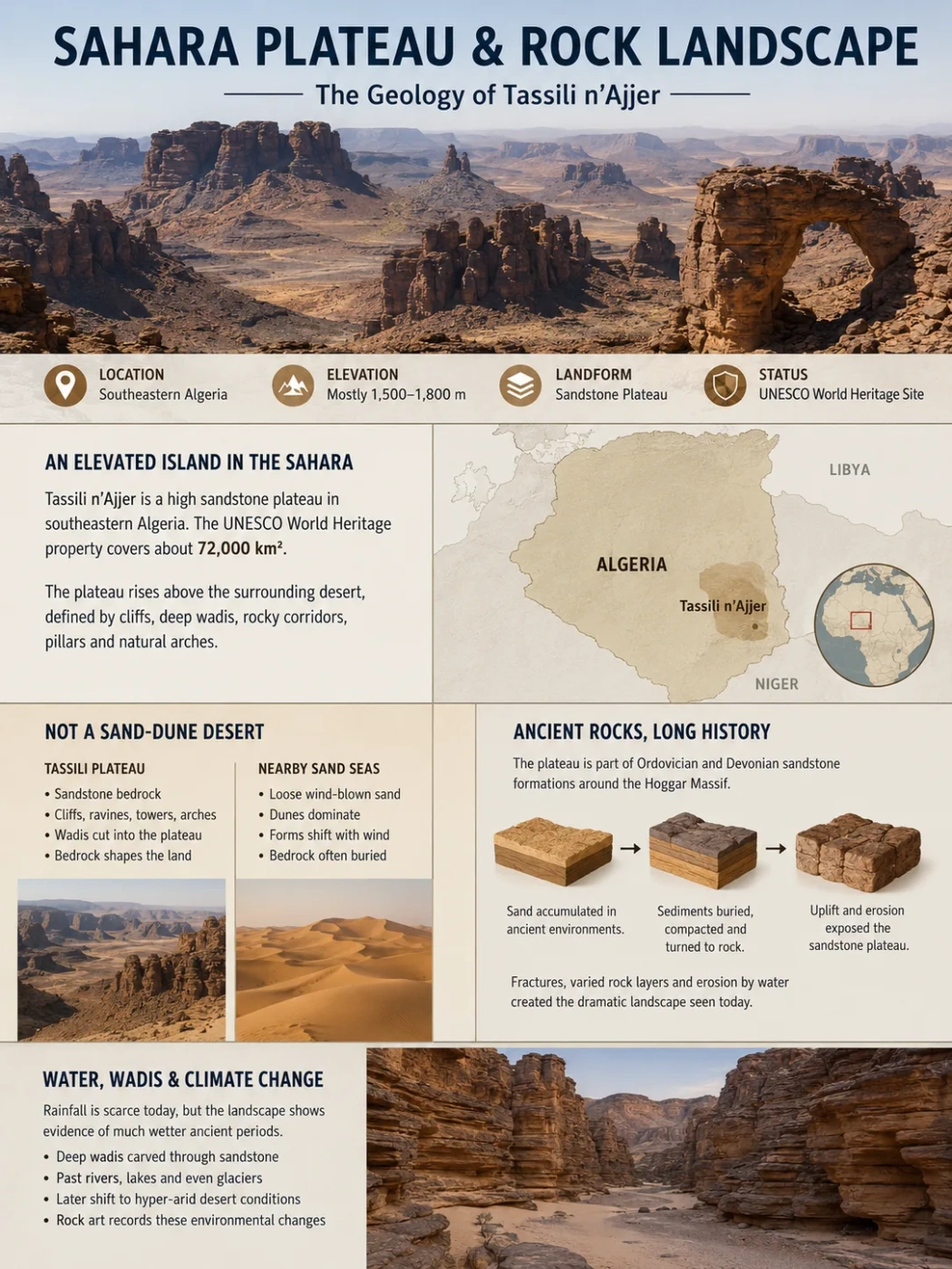
Tassili n’Ajjer is a high sandstone plateau in southeastern Algeria where deeply cut wadis, cliffs, narrow passages, isolated pillars and natural arches rise above surrounding Saharan sand. Its rock landscape records several very different environments, including ancient rivers, Paleozoic glaciers and the later spread of hyper-arid desert conditions.
Sandstone Plateau
Mostly 1,500–1,800 m
UNESCO World Heritage Site
A Rocky Plateau Rising Above the Sahara
Tassili n’Ajjer occupies a large elevated area of the central Sahara in southeastern Algeria, close to the borders with Libya and Niger. The UNESCO World Heritage property covers about 72,000 square kilometres, making the landscape much larger than the individual rock-art localities for which it is often known.
The main plateau commonly lies around 1,500 to 1,800 metres above sea level. This elevation helps separate Tassili n’Ajjer physically from the lower sand seas and desert plains around it. From a distance, parts of the massif can appear as broad elevated surfaces bounded by cliffs. At closer range, however, the surface is broken into ravines, rocky corridors, residual towers and enclosed depressions.
Plateau and Protected-Area Boundaries
Tassili n’Ajjer can refer to the physical sandstone massif as well as protected areas associated with it. Published areas therefore vary according to the boundary being measured. The 72,000 km² figure refers to the UNESCO World Heritage property rather than every administrative or biosphere-reserve boundary connected with the region.
Why Tassili n’Ajjer Is Not a Typical Sand-Dune Desert
The Sahara contains large ergs, where wind-built dunes dominate the surface, but Tassili n’Ajjer is fundamentally different. Its defining landform is exposed bedrock. Sand occurs between and around the rocks, yet much of the landscape is controlled by thick sandstone layers that have been fractured and dissected.
Tassili Plateau
- Built mainly from consolidated sandstone strata
- Contains cliffs, ravines, rock towers and arches
- Wadis cut into the elevated surface
- Bedrock controls much of the visible relief
Nearby Sand Seas
- Dominated by loose wind-transported sediment
- Dunes form much of the visible relief
- Surface forms can migrate as wind moves sand
- Bedrock may be buried beneath sandy deposits
This contrast is visible even in satellite imagery. Sand forms broad pale expanses around darker rocky surfaces, while the plateau appears as a dissected mass rather than a continuous dune field. The boundary is not always sharp because dunes can enter valleys and accumulate against cliffs.
The Sandstone Structure Behind the Rock Landscape
Tassili n’Ajjer belongs to a broad sandstone region surrounding the older crystalline rocks of the Hoggar. UNESCO describes the plateau as part of Ordovician and Devonian sandstone formations associated with this older Precambrian foundation.
The strata preserve a long sequence of changing environments. Sand accumulated hundreds of millions of years ago, was buried and hardened into rock, and later became exposed as erosion removed overlying material. The resulting sandstone is not one uniform block. Bedding surfaces, differences in rock resistance and networks of fractures give water and weathering natural lines to follow.
The plateau also slopes gently toward the northeast into the Illizi and Murzuq basin region. Wadis have cut deeply into parts of the elevated sandstone, so the modern landform combines broad structural surfaces with areas of intense dissection.
Ancient sedimentary environments deposited thick bodies of sand and related sediments.
Burial and cementation converted the accumulated sediment into sandstone strata.
Erosion removed material and cut valleys into the elevated sandstone surface.
Continued weathering enlarged fractures and separated resistant masses into cliffs, pillars, passages and arches.
Water Carved Much of the Plateau Before Wind Refined It
Tassili n’Ajjer’s present climate is extremely dry, but its landforms cannot be explained by wind alone. Many of its larger valleys and ravines developed when running water had a stronger role in the regional landscape. UNESCO describes the plateau morphology as having been carved by water and later modified by wind.
Water follows fractures and weaker rock layers. Over long periods, channels deepen and widen, separating blocks of sandstone from the surrounding plateau. Where erosion attacks a rock mass from several sides, narrow walls, columns and isolated residual forms can remain.
Wind acts differently. Sand carried close to the ground can abrade exposed surfaces, while loose grains and weathered fragments are removed from cracks and sheltered passages. Wind therefore helps reshape and clean out forms whose larger structural pattern often began through jointing, weathering and water erosion.
How the “Rock Forests” Form
The well-known rock forests are dense concentrations of standing sandstone masses separated by passages and openings. They are erosional remnants rather than rocks that were deposited individually in their present shapes.
Closely spaced joints divide sandstone into blocks. Weathering attacks corners, bedding contacts and fracture walls. Material is gradually removed, passages widen, and the more resistant parts remain standing. Some remnants become narrow towers or mushroom-like forms, while others retain connections that produce natural arches.
Joints break the sandstone mass into natural blocks and create pathways for weathering and runoff.
Occasional rainfall concentrates in cracks and channels, removing loosened sediment and cutting into the rock.
Repeated physical breakdown enlarges openings and weakens exposed edges and bedding surfaces.
Wind-driven sand continues to modify exposed surfaces and removes loose material from the dry landscape.
The Plateau Preserves Evidence of an Ice-Age Sahara
One of Tassili n’Ajjer’s less obvious geological features formed in an environment almost opposite to the Sahara of today. During the Late Ordovician, roughly 440 million years ago, large ice sheets covered parts of the ancient Gondwanan continent, including areas now within North Africa.
Rock surfaces in the wider Tassili region preserve grooves, striations and streamlined forms produced beneath moving ice. These glacial pavements occur along a broad belt of the central Sahara and are especially useful because some former ice-flow surfaces are exposed over large areas.
The preserved features allow geologists to reconstruct the movement of ancient ice streams. Some surfaces record several phases of glacial flow rather than one isolated event. The same sandstone landscape that now receives very little rainfall therefore contains physical evidence of continental glaciation hundreds of millions of years earlier.
A Landscape With More Than One Climate History
The modern desert surface should not be used as a model for the entire geological history of Tassili n’Ajjer. Its rocks record Paleozoic glacial conditions, later sedimentary environments, wetter periods with active drainage and the much drier conditions that dominate the Sahara today.
Wadis Cut Through the High Sandstone Surface
Drainage lines are still an important part of the plateau even though continuous rivers are absent across most of the region. Wadis cross and dissect the sandstone. For much of the year their channels may be dry, but rainfall can produce concentrated runoff through valleys and narrow gorges.
This intermittent water matters geomorphologically. A dry-climate channel can spend long periods without flowing and still perform substantial erosional work during short flood events. Water moving through bare rocky terrain can enter fractures, transport debris and remove sediment from confined channels.
The result is a landscape where apparent dryness coexists with a clear drainage pattern. Ravines, canyon-like passages and valley floors preserve the path of water even when no surface flow is present.
Gueltas Create Small Wet Refuges Within the Plateau
Some channels and depressions retain water after rainfall. These natural pools are known as gueltas. Depending on their setting and water supply, they may be temporary or persist much longer than water on exposed desert surfaces.
The combination of elevation, shaded ravines, sandstone storage and protected valley floors creates small local environments that differ sharply from the surrounding hyper-arid plateau. UNESCO’s biosphere-reserve description notes wadis, permanent and temporary waterholes, humid valley vegetation and aquatic plants within Tassili n’Ajjer.
These wet pockets are small compared with the plateau itself, but they show how relief controls water availability in desert terrain. A deep shaded channel can lose water more slowly than a broad exposed plain, while fractures and porous sandstone can influence how rainfall moves through the rock.
Relict Plants Survive in the Highland Terrain
Tassili n’Ajjer also contains plant communities that would be unexpected on an open Saharan plain. Higher ground and sheltered valleys provide local microclimates where moisture conditions differ from the surrounding desert.
Among the best-known plants is the Saharan cypress, Cupressus dupreziana, a rare tree associated with the Tassili highlands. Wild olive and Saharan myrtle are also part of the relict mountain flora recorded in the region.
Their presence does not mean the plateau has a generally moist climate. Most of Tassili n’Ajjer remains hyper-arid. Instead, these plants occupy scattered habitats where elevation, topography and local water availability have allowed populations to persist.
Rock Shelters Link the Landform to a Wetter Sahara
The plateau’s sandstone erosion created thousands of walls, overhangs and sheltered rock faces. These physical surfaces later became closely tied to the archaeological record of Tassili n’Ajjer.
More than 15,000 drawings and engravings have been recorded within the World Heritage property. Their importance goes beyond archaeology because many images depict animals and ways of life associated with environmental conditions different from those of the modern desert.
Representations include water-dependent animals such as hippopotamuses as well as later pastoral scenes. Together with sediments, landforms and other environmental evidence, the rock art helps show that the Sahara experienced major shifts in rainfall, vegetation and habitat through the period of human occupation represented at Tassili.
The connection is unusually direct: erosion produced the shelters and rock walls, wetter climatic phases supported very different ecosystems around them, and the people who occupied those landscapes left visual records on the sandstone itself.
A Plateau Made From Overlapping Landscapes
Tassili n’Ajjer is not simply one flat high surface covered with unusual rocks. Broad sandstone benches, escarpments, deeply incised wadis, enclosed passages, rock forests, sandy pockets and water-holding depressions occur within the same plateau system.
Elevated sandstone strata form broad rocky areas and structural benches.
Fractures, wadis and erosion divide the sandstone into gorges, corridors, pillars and rock forests.
Rocky slopes meet lower plains and sand accumulations, creating sharp local contrasts between exposed bedrock and dunes.
Its modern appearance is therefore the product of processes operating at very different scales. Ancient sedimentation created the sandstone, tectonic and structural relationships influenced the broad plateau, former glaciers marked some surfaces, river systems cut drainage routes, and later weathering and wind worked those forms into the exposed rock landscape visible today.