Algeria · High Plains and Closed Basins
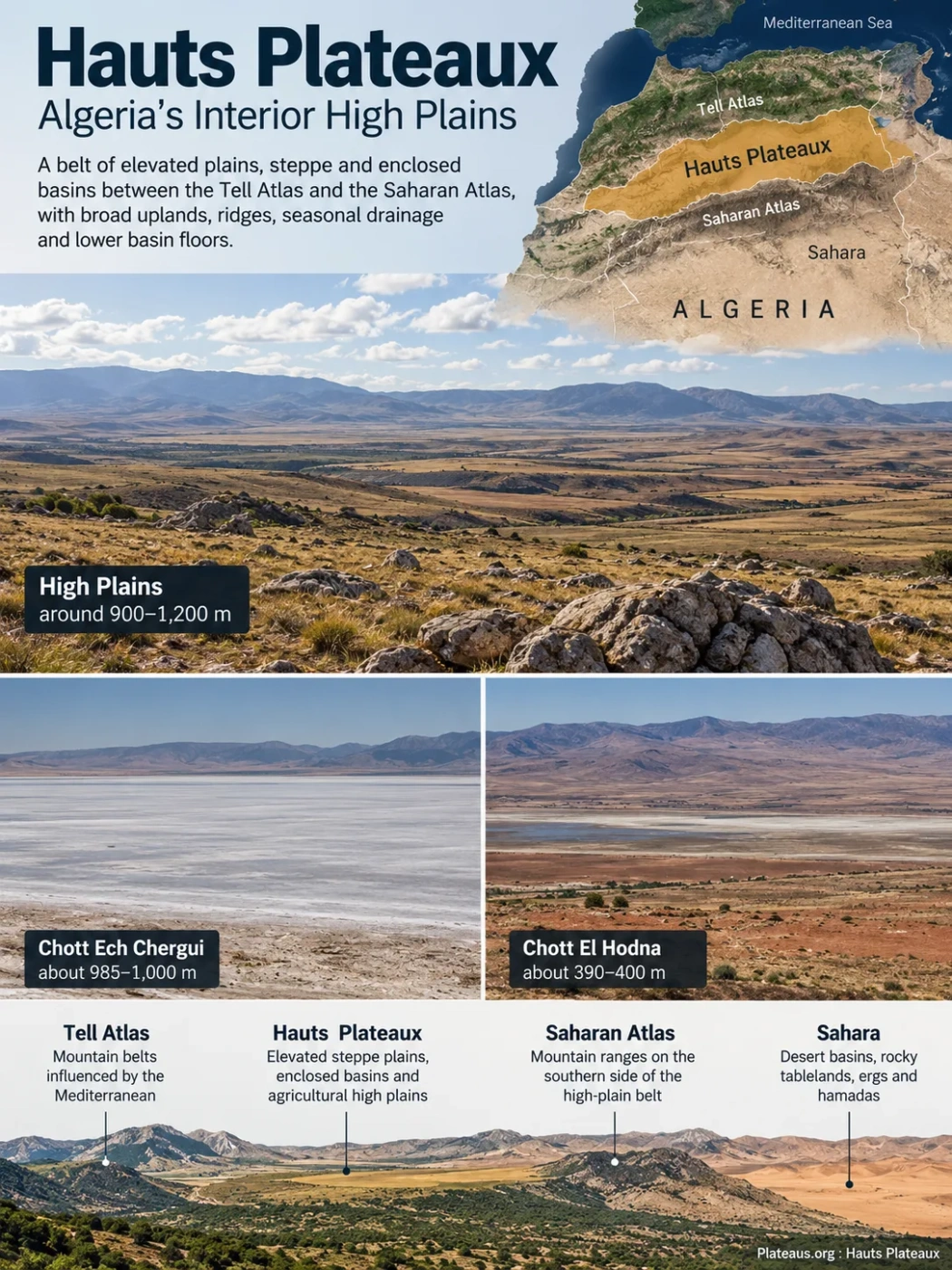
The Hauts Plateaux are a long belt of elevated plains, steppe and enclosed basins between Algeria’s Tell Atlas and Saharan Atlas. The region is not one flat plateau: broad uplands around 1,000 metres alternate with ridges, seasonal drainage, salt depressions and much lower basin floors such as the Hodna.
Semi-Arid Steppe
Chotts and Closed Basins
The Hauts Plateaux Form Algeria’s Interior Atlas Belt
The name Hauts Plateaux, literally “High Plateaus,” refers to the broad interior high plains of northern Algeria. They extend across much of the country from the western high plains near Morocco toward the Sétif and Oum El Bouaghi region in the east.
Their position is easier to understand as a sequence of relief belts. The Tell Atlas and associated northern mountains stand between much of the interior and the Mediterranean. South of them, relief opens into the Hauts Plateaux. The Saharan Atlas rises along the southern side of this interior belt before the terrain passes into the Sahara.
Mountain belts and interior valleys influenced more strongly by the Mediterranean north.
Elevated steppe plains, enclosed basins, chotts and agricultural high plains.
Mountain ranges and ridges forming the southern side of the high-plain belt.
Desert basins, rocky tablelands, ergs, hamadas and separate Saharan uplands.
This position separates the Hauts Plateaux from Algeria’s large Saharan plateaus. Tassili n’Ajjer, Tademaït and other desert tablelands lie within the Sahara and belong to different geological and climatic settings. The Hauts Plateaux are an Atlas-zone high-plain system with a large steppe component.
Why the Region Is Not One Flat Plateau
The plural name is useful. The Hauts Plateaux contain extensive surfaces with low local relief, but these are interrupted by low ridges, mountain outliers, shallow troughs and much deeper enclosed basins. A traveller crossing the region can therefore move between apparently level high country and depressions hundreds of metres lower without leaving the wider physiographic belt.
Landform Note
High plains often describes the Hauts Plateaux more accurately than imagining a single table-shaped plateau. The regional identity comes from the broad belt of elevated interior terrain, not from one continuous level surface.
The contrast is clear in measured elevations. Large parts of the Sétif high plains lie roughly between 900 and 1,200 metres. Chott Ech Chergui in the western high-plateau system lies close to 1,000 metres. Farther east, the floor of the Hodna depression drops to only about 390–400 metres.
| Representative Area | Elevation | What It Shows |
|---|---|---|
| Sétif high plains | About 900–1,200 m across much of the high-plain terrain | Broad elevated plains can stand around or above 1,000 m. |
| Chott Ech Chergui | About 985–1,000 m | A large closed drainage system can itself occupy high terrain. |
| Chott El Hodna | About 390–400 m | Deep basin floors can lie far below surrounding high plains and mountains. |
These figures should not be combined into a single average elevation for the entire region. They describe different types of terrain and show why one number can hide the physical structure of the Hauts Plateaux.
Folded Atlas Terrain and Basin Floors Shape the High Plains
The Hauts Plateaux belong to the tectonically active geological domain of northern Algeria rather than to the old Saharan platform farther south. Movements associated with the development of the Atlas systems folded and faulted sedimentary rocks while creating or modifying basins between zones of higher relief.
The modern landscape therefore combines structural relief with younger basin fill. Broad plains commonly occupy areas where erosion and sediment accumulation have reduced local relief, while depressions contain younger continental sediments, fine material carried by intermittent runoff and, in saline basins, evaporite deposits.
The Hodna illustrates this basin component especially well. It occupies a closed depression between surrounding mountain and highland sectors rather than the top of a uniformly raised block. Other parts of the Hauts Plateaux contain shallower closed depressions that end in chotts or sebkhas.
This structure explains why the region can appear exceptionally open while still containing pronounced elevation differences. The wide horizons belong to plains and basin surfaces; the surrounding Atlas structures control many of their boundaries.
Water Often Flows Inward Instead of Reaching the Sea
One of the defining physical features of the Hauts Plateaux is endorheic drainage. In an endorheic basin, runoff terminates inside the basin rather than following a river to the ocean. Across the high plains, seasonal streams and wadis carry water from slopes and uplands toward enclosed depressions.
Because rainfall is limited and evaporation is strong, much of this water does not remain as a permanent lake. It spreads over shallow basin floors, evaporates or infiltrates, leaving salts and fine sediments behind.
Water reaches surrounding slopes, ridges and high plains during wet periods.
Short-lived flows move runoff toward the lowest parts of enclosed basins.
Water spreads across shallow saline depressions rather than continuing to the Mediterranean.
Water retreats during dry periods, exposing mud, salt crusts and saline soils.
This drainage pattern is not a minor local feature. Closed basins are numerous across the Hauts Plateaux, and some collect runoff from very large catchments. Chott Ech Chergui, for example, is associated with a drainage basin of roughly 40,000 km².
Chotts Are Seasonal Landscapes, Not Simply Salt Lakes
A chott may appear on a map as a lake-like feature even when much of its surface is dry. Water extent changes sharply with rainfall, runoff and evaporation. Shallow water, marshy patches and saline pools may develop during wetter periods, while exposed salt and mud flats dominate during dry periods.
Chott El Hodna provides a clear example. Its closed drainage basin covers about 26,000 km², with runoff entering from surrounding terrain through numerous wadis. The chott can receive extensive winter flooding, but summer conditions expose strongly saline ground and salt crust.
Chott Ech Chergui occupies a very different elevation setting but follows the same broad closed-basin principle. Its wetland system includes saline and brackish water, freshwater elements, springs and steppe around the depression rather than one permanent sheet of open water.
Chott and Sebkha Terminology
North African sources do not always use chott and sebkha in exactly the same way. Some descriptions use sebkha for the bare or strongly saline central depression and chott for the wider wetland and vegetated saline margin. Other geographic sources use chott more broadly for the entire salt-lake depression. The physical setting is more useful than treating the two words as perfectly fixed categories.
The Western, Central and Eastern High Plains Have Different Landscapes
The Hauts Plateaux stretch far enough across Algeria that no single locality represents the whole region. Rainfall, elevation, basin geometry, soils and land use change from west to east.
| Sector | Representative Areas | Landscape Pattern |
|---|---|---|
| Western high plains | Naâma, El Bayadh and the Chott Ech Chergui region | Open steppe, large closed basins, saline depressions and extensive pastoral landscapes. |
| Central high plains | Tiaret, Djelfa and the Zahrez depressions | Steppe plains broken by ridges, enclosed drainage and broad chott systems. |
| Hodna basin | M’Sila and adjoining Batna sector | A pronounced low closed basin receiving runoff from higher terrain on several sides. |
| Eastern high plains | Sétif, Bordj Bou Arréridj and Oum El Bouaghi | Higher cereal-growing plains mixed with steppe, mountains and numerous seasonal saline wetlands. |
These are representative landscape sectors rather than rigid administrative subdivisions. The physical transitions are gradual, and local mountain ranges and basins interrupt any simple west-to-east division.
A Semi-Arid Plateau Can Still Have Cold Winters
The Hauts Plateaux are drier than much of Algeria’s Mediterranean north, but they are not simply an extension of the hot Sahara. Their elevation and inland position produce a more continental climate, with hot, dry summers and cold winters. Frost is common in many elevated areas, and snow can occur in the colder eastern and mountain-influenced sectors.
Rainfall also varies substantially across the plateau belt. The eastern high plains around Oum El Bouaghi include semi-arid to arid environments where annual totals can be low, while higher and more northerly sectors receive more moisture. Local relief changes exposure to Mediterranean weather systems, so rainfall cannot be represented accurately by one regional figure.
For vegetation and farming, timing matters as much as the annual total. Long-term rainfall research from the Sétif and Bordj Bou Arréridj high plains identifies a broad rainy and cereal-growing period from roughly September to May. The record also shows that changes in the number of useful rainy days can affect crops even when a seasonal total alone appears adequate.
Steppe Vegetation Changes with Soil, Moisture and Salinity
Much of the natural vegetation of the Hauts Plateaux belongs to the North African steppe. Plant cover is generally open rather than forming continuous woodland or dense grassland. Its composition changes over short distances because shallow relief differences affect drainage, soil texture and salt accumulation.
Stipa tenacissima, commonly called alfa or esparto grass, has historically formed broad steppe communities across parts of the high plains.
Artemisia herba-alba and other low shrubs become prominent in many semi-arid steppe settings.
Species composition shifts where soils become sandier, vegetation is disturbed or mobile material accumulates.
Salt-tolerant plants occupy parts of chott and sebkha margins, while the most saline central surfaces may remain almost bare.
Other characteristic steppe plants include Lygeum spartum, while saline margins can support halophytic vegetation such as Salicornia and Atriplex. Their distribution is patchy because the high plains contain a mosaic of soils rather than one uniform steppe substrate.
Alfa Grass Once Defined Large Areas of the High Plains
Stipa tenacissima is closely associated with the landscape identity of the Algerian steppe. Dense alfa formations once occupied very large areas between the Tell Atlas and Saharan Atlas. The tough perennial grass can persist under dry conditions and helps protect soil by maintaining plant cover on otherwise exposed surfaces.
Alfa also has a long history of economic use as a fibre plant. Its ecological role is different from that of an agricultural crop, however. Where mature alfa steppe is broken apart by heavy grazing, cultivation or repeated drought, exposed soil becomes more vulnerable to erosion and replacement by poorer or more disturbance-tolerant vegetation.
Long-term field studies in Algerian steppe environments have documented severe local declines in Stipa tenacissima, including sites where formerly dominant stands disappeared after decades of grazing pressure and drought. The pattern is not identical everywhere, so degraded local sites should not be treated as proof that alfa has vanished from the entire Hauts Plateaux.
Salt Depressions Add Wetland Habitats to an Arid Landscape
Although much of the Hauts Plateaux is dry steppe, its closed basins create seasonal wetlands with very different ecological conditions. Temporary freshwater pools, brackish water, salt marshes, saline lakes and bare salt flats can occur within the same basin complex.
The eastern high plains around Oum El Bouaghi contain several examples. Endorheic depressions such as Garaet Guellif and nearby seasonal wetlands fill and contract according to rainfall and runoff. Salt-encrusted margins support halophytic plants, while temporary open water provides habitat for waterbirds.
Chott Ech Chergui and Chott El Hodna also contain wetland habitats much more varied than the simple label “salt lake” suggests. Springs, shallow pools, marsh vegetation, steppe margins and bare saline surfaces can occur close together because water depth and salinity change across the basin floor.
Cereal Plains and Pastoral Steppe Occupy the Same Regional Belt
Human land use follows the environmental gradient across the Hauts Plateaux. Sheep grazing is widespread through the drier steppe, while rainfed cereal cultivation becomes more prominent where rainfall and soils allow dependable cropping.
The Sétif and Bordj Bou Arréridj high plains are among the clearest agricultural examples. Wheat, barley and other cereals occupy large parts of the eastern high-plain landscape. Production remains closely tied to rainfall because much of the cropping is rainfed.
Long rainfall records from this eastern sector show why total annual precipitation can be a poor measure of agricultural conditions. Rain that falls outside the crop’s most useful growth stages cannot compensate fully for missing rainfall during germination, vegetative growth or grain development. Recent analysis of the long Sétif–Bordj Bou Arréridj record found fewer rainfall events above 5 mm and fewer useful rainy days during parts of the cereal cycle, even though the most recent multi-decade period was not simply the driest in total monthly rainfall.
Steppe Degradation Is Changing the Plateau Surface
The most persistent environmental pressure across many parts of the Hauts Plateaux is loss or thinning of natural steppe cover. The process has several interacting causes: repeated drought, heavy grazing pressure, conversion of marginal rangeland to cultivation and agricultural practices that leave fragile soils exposed.
Vegetation loss changes more than plant composition. Bare ground is more easily eroded by wind and runoff, soil organic matter can decline, sandy material becomes more mobile and the remaining pasture carries greater pressure from livestock.
Satellite monitoring shows that these changes are spatially uneven rather than a simple line of continuous decline. A recent Landsat-based study of the Naâma steppe tracked strong falls and partial recoveries in vegetation cover over several decades. The pattern shows why a single satellite image can misrepresent long-term condition: rainfall, grazing and restoration can produce large swings in green cover from one period to another.
Reading Steppe Change
A greener satellite image does not automatically mean that the original alfa-steppe ecosystem has recovered. Vegetation indices measure surface greenness, while ecological recovery also depends on which species return, how continuous the perennial cover becomes and whether soils regain stability.
Current restoration work in Algeria includes steppe ecosystems, alfa areas, degraded rangelands and watershed zones within the wider Green Dam rehabilitation programme. These restoration areas overlap parts of the Hauts Plateaux and Saharan Atlas transition, but the Green Dam and the Hauts Plateaux are not identical geographic regions.