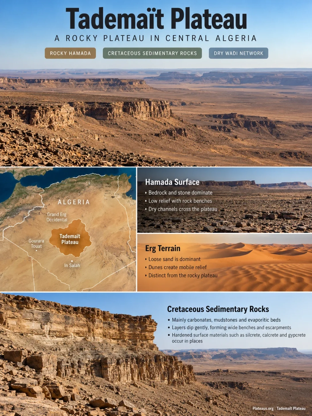
Central Algerian Sahara
The Tademaït Plateau is a broad rocky tableland in central Algeria, commonly described as a hamada. Its plateau form comes less from high peaks than from a wide, gently structured surface of Cretaceous sedimentary rocks, step-like margins, dry drainage, and a clear contrast with surrounding desert basins and sand seas.
Cretaceous sedimentary cover
Dry wadi network
A Plateau Defined by Surface Continuity, Not Mountain Relief
Tademaït occupies part of the central Algerian Sahara between the Gourara–Touat country to the west, the In Salah region to the south, and other Saharan tablelands and basins farther east. The Grand Erg Occidental lies to the north and northwest, creating one of the clearest regional contrasts: a hard, stony plateau beside a major dune-dominated sand sea.
The name appears in mapping and geological literature as Tademaït, Tademait, and sometimes Tadmaït. These spellings refer to the same regional plateau rather than separate landforms.
Much of the plateau has low local relief. Broad surfaces can look almost plain-like when viewed from ground level, yet they remain elevated above adjoining depressions and are bounded in places by escarpments and stepped rock benches. Geological work in the Krechba sector describes the plateau at roughly 600 m above sea level, while a mapped reference point is listed near 621 m. Neither number should be treated as a uniform elevation for the whole Tademaït surface.
Elevation Note
Point elevations and local sector averages describe different parts of Tademaït. The plateau is a broad regional surface, not a single summit, so one quoted elevation cannot represent every margin, terrace, and interior sector.
Why Tademaït Is a Hamada Rather Than an Erg
Large parts of the Sahara are not covered by dunes. Tademaït is a useful example because its dominant surface is hard and rocky. In Saharan geomorphology, hamada describes this kind of bare or stony desert terrain, commonly developed on resistant bedrock and hardened surface materials. An erg, by contrast, is a large sand sea dominated by dunes.
Tademaït Hamada
- Bedrock and stone dominate the surface.
- Low rock benches and escarpments shape the relief.
- Dry channels cut or cross parts of the plateau.
- Wind removes fine material from exposed surfaces.
Nearby Erg Terrain
- Loose sand is the dominant surface material.
- Dunes create mobile or semi-mobile relief.
- Wind-built forms are more prominent than rock benches.
- The visible landscape can change as dunes migrate.
This difference matters when reading satellite imagery. Tademaït appears as a broad, comparatively coherent rocky surface, while nearby dune fields show repeated ridges, streaks, and lighter-toned sand patterns.
Nearly Horizontal Cretaceous Rocks Create the Stepped Surface
The plateau is built largely from Late Cretaceous sedimentary rocks, including carbonates, mudstones, and evaporitic beds. In parts of Tademaït these layers dip only very gently, allowing resistant beds to preserve wide benches while weaker layers retreat more readily. The result is a sequence of low terraces and escarpments rather than a sharply folded mountain landscape.
Near the northern margin, the surface record is even more varied. Mineralogical work has identified a dolomitic limestone cap together with local silcrete, calcrete, and gypcrete. These hardened crusts are not interchangeable: silcrete is silica-rich, calcrete is cemented mainly by calcium carbonate, and gypcrete is rich in gypsum. Their occurrence shows that the modern stony surface is not simply exposed bedrock; long periods of weathering, mineral movement, erosion, and desert surface development have also modified it.
Broad, low-relief rocky surface on gently dipping sedimentary beds.
Harder limestone or indurated material can hold a step in the landscape.
Erosion exposes the layered structure where the plateau drops toward lower terrain.
The Rock Record Changes From Rivers and Dunes to a Shallow Sea
Tademaït’s modern hyper-arid surface hides a very different Cretaceous history. Detailed work on northern sections shows a shift from terrestrial sedimentation to marine conditions during the Cenomanian and Turonian. The sequence records braided river systems and wind-blown dune–interdune environments, followed by deposition on a shallow marine ramp as sea level rose along the southern side of the Tethyan realm.
Clastic sediment accumulated in terrestrial channels and associated floodplain settings.
Wind became an important depositional agent as sandy desert environments expanded.
A marine transgression brought carbonate and marl deposition over parts of the northern plateau.
The northern Tademaït succession is commonly divided into several named units. Their ages and environmental meaning are better constrained in some intervals than in others, so the formation names are most useful when tied to the studied sections rather than applied as a perfectly uniform stack across the entire plateau.
| Unit | Broad Age | What It Records |
|---|---|---|
| Gara Samani Formation | Probably early Cenomanian | Clastic terrestrial deposits associated with fluvial and aeolian environments. |
| El Golea Clays | Lower to middle Cenomanian | A fine-grained Cenomanian interval lying below younger marine units in the studied northern succession. |
| Gour Louazouaza Formation | Upper Cenomanian into lower Turonian intervals | Marine limestones and marls, including fossil-rich horizons used for correlation. |
| Ain El-Hadjaj Formation | Often assigned to the Campanian; age remains less secure | Younger part of the preserved Upper Cretaceous succession in the studied northern area. |
Marine Fossils Explain Why a Desert Plateau Records an Ancient Sea
Fossil-bearing beds in northern Tademaït contain ammonites and other marine macrofossils, including bivalves, oysters, gastropods, and echinoids. Some Cretaceous levels also preserve vertebrate remains. These fossils help geologists match beds between sections and refine the age of the Cenomanian–Turonian succession.
The marine fossils do not indicate that the modern Sahara was recently submerged. They belong to rock formed tens of millions of years before the present desert landscape. During parts of the Late Cretaceous, shallow seas extended across areas of the Saharan Platform, leaving carbonate, marl, and fossil-rich deposits that are now exposed high and dry.
What the Fossils Actually Show
Marine fossils provide evidence for Cretaceous marine deposition. The modern plateau surface developed much later through uplift, erosion, weathering, and long-term desert landscape evolution.
Dry Valleys Still Organize Runoff Across the Plateau
Tademaït has no dense network of permanent rivers, but it does have wadis, ravines, and dry drainage traces. These channels matter because rare rainfall can produce short-lived surface flow over hard or poorly infiltrating ground. Water then concentrates into existing channels and moves toward lower terrain around the plateau margins.
Some drainage lines reflect a longer geomorphic history than the present climate alone. Saharan landscapes have passed through wetter and drier phases, and inherited valleys can remain visible even when modern flow is infrequent. The size of a dry channel therefore should not be read as a direct measure of today’s rainfall.
Storms wet only part of the plateau and may be widely separated in time.
Water moves across rock, crusted ground, and shallow sediment where infiltration is limited.
Flow collects in channels and ravines that cross or cut the plateau surface.
Drainage leaves the plateau through margins and continues toward surrounding depressions.
The Plateau Also Matters Below Ground
The exposed and near-surface sedimentary rocks around Tademaït connect the landform to the Continental Intercalary aquifer system, one of the major groundwater bodies beneath the northern Sahara. Hydrogeological work west of the plateau shows groundwater moving away from Tademaït toward parts of Touat, Adrar, and Reggane, while other recharge enters the wider aquifer system from additional outcrop zones, including the Saharan Atlas margin.
This relationship helps explain why a surface that looks almost waterless can still be part of a much larger groundwater system. In western oasis regions, traditional foggara galleries tap groundwater where local topography and aquifer geometry allow gravity-fed flow. Tademaït is therefore relevant to the hydraulic setting of nearby oasis belts even though permanent surface water is scarce.
Groundwater Note
Tademaït should not be described as the sole source of the Continental Intercalary. The aquifer extends across a vast Saharan sedimentary basin and receives water through more than one recharge and outcrop zone.
Vegetation Follows Temporary Water and Local Microhabitats
The plateau’s hyper-arid climate keeps plant cover sparse over large areas, especially on exposed stony surfaces. Vegetation is more likely to persist where runoff collects, where shallow sediment can hold moisture, or where a wadi provides slightly better growing conditions than the open hamada.
Field inventories on Tademaït have recorded both perennial and ephemeral plants. Perennial grasses and drought-tolerant shrubs can survive long dry periods, while short-lived species may appear after rain and then disappear as surface moisture is lost. This produces a patchy ecological pattern rather than a continuous desert plant cover.
A 2024 field survey at Labiode, Oued Talh, and Oued In Belbel also documented seasonal differences in plant occurrence along camel-grazing routes. The finding fits the plateau’s physical geography: wadis and temporary moisture zones can support a noticeably richer plant assemblage than the exposed rock surface only a short distance away.
How Tademaït Can Be Read on Satellite Imagery
Satellite and astronaut imagery are especially useful for Tademaït because the landform is defined at a regional scale. Orbital views of the plateau reveal the broad rocky surface, drainage traces, and the contrast between plateau terrain and nearby dune fields more clearly than a single ground-level view can.
Surface Pattern
Broad Rocky Texture
Look for a comparatively continuous stony or bedrock surface rather than repeating dune ridges.
Plateau Edge
Steps and Escarpments
Margins can appear as long tonal or topographic breaks where resistant beds stand above lower terrain.
Drainage
Branching Dry Channels
Wadi patterns cut across the surface and converge toward outlets along lower margins.
Regional Contrast
Rock Beside Sand
Nearby ergs show dune textures that differ sharply from the flatter, harder plateau surface.