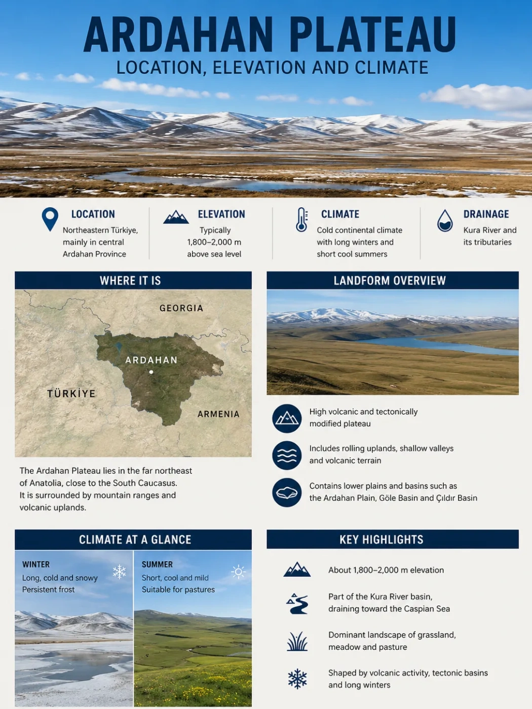
The Ardahan Plateau occupies the high central part of Ardahan Province in northeastern Türkiye, where broad uplands generally stand about 1,800–2,000 metres above sea level. Its elevation helps produce long, severe winters and short, cool summers, while the Kura River and its tributaries have cut valleys through a surface built largely on Neogene volcanic rocks.
Where the Ardahan Plateau Sits
The Ardahan Plateau lies in northeastern Anatolia, close to the transition between the high interior of Eastern Anatolia and the mountainous lands toward the eastern Black Sea region. The name refers specifically to the high plains in the central part of Ardahan Province, rather than to the whole province.
This distinction matters because Ardahan contains several different terrain types. Mountains rising above 3,000 metres surround or border parts of the central highland, while lower plains and basins occupy depressions within the wider relief. The Yalnızçam Mountains extend along the northern and northwestern side of the province. Keldağ lies to the northeast, Akbaba Mountain to the east, and Kısır Mountain rises south of the central Ardahan area. Kısır reaches 3,197 metres, more than a kilometre above much of the plateau surface.
Mountain terrain includes peaks above 3,000 m around parts of the Ardahan highlands.
Broad central uplands generally about 1,800–2,000 m above sea level.
The lower area within the central highland is identified separately as the Ardahan Plain.
The plateau is therefore best understood as part of a relief system rather than as an isolated flat platform. Mountain masses, a lower central plain, river valleys and broad upland surfaces occur within a relatively small elevation range horizontally but differ sharply in their local topography.
Elevation Is a Range, Not a Single Number
The commonly reported elevation of the Ardahan Plateau is 1,800–2,000 metres. That range describes the main high surface and is more useful than assigning the plateau one exact elevation. A plateau covers an area; it is not a single surveyed point. River incision, gentle upland relief and lower internal surfaces all cause elevation to vary from place to place.
Ardahan city and the central plain occupy the lower part of this setting at roughly the lower end of the plateau’s elevation range. The surrounding mountains rise much higher. This combination explains why a landscape that appears broadly open and level can still have strong local relief at its margins.
Ardahan Plateau and Ardahan Plain Are Not the Same Landform
Ardahan Plateau is the wider high surface in the central part of the province. The Ardahan Plain is the lower central area within that highland setting. Treating the two names as interchangeable removes an important part of the local topography.
The relationship can be visualized as a high landscape with different levels rather than as a perfectly horizontal tableland:
Several surrounding summits exceed 3,000 m.
Main upland generally about 1,800–2,000 m.
Lower surfaces occupy depressions and river corridors within the highland.
This diagram shows the relative landform relationship only; it is not a scale elevation profile.
Volcanic Ground Cut by the Kura River
The plateau’s relatively broad high surface is closely tied to the volcanic history of northeastern Anatolia. The bedrock beneath much of the Ardahan Plateau includes lava produced by Neogene volcanism. The wider northeastern Anatolian highlands also contain extensive volcanic successions ranging from lava flows to pyroclastic units.
Volcanism alone does not explain the landscape visible today. After volcanic materials accumulated across the region, drainage progressively modified the high surface. The most important river is the Kura River, which crosses the Ardahan highlands and is joined by tributaries that cut into the plateau. The result is a dissected upland rather than an uninterrupted flat sheet.
Lava and other volcanic materials helped build extensive high surfaces in northeastern Anatolia.
Broad uplands developed at elevations commonly around 1,800–2,000 m in central Ardahan.
The Kura and its tributaries cut valleys into the volcanic highland and broke up the surface.
The Kura is therefore part of the plateau’s physical identity, not simply a river that happens to cross it. River incision helps explain the contrast between open uplands and more sharply defined valley corridors.
Why the Ardahan Plateau Has Such a Cold Climate
The plateau has a strongly continental climate, and elevation is central to understanding it. Most of the main surface lies close to 2,000 metres above sea level. At this height, temperatures remain much lower than in nearby lowlands, the cold season lasts longer, and snow can persist well beyond individual snowfall events.
Distance from strong maritime moderation reinforces the effect. Although Ardahan Province lies relatively close to the Black Sea region, the central plateau is separated from the coast by mountainous terrain. The interior highland consequently experiences much larger seasonal temperature changes than a coastal location at a similar latitude.
Long-term meteorological observations for Ardahan show the scale of this seasonal contrast. Mean monthly temperature is −11.2°C in January but rises only to 16.0°C in July and 16.1°C in August. Even at the warmest point of the year, the monthly mean remains moderate compared with lower parts of Türkiye.
The cold season also extends beyond midwinter. Long-term monthly mean temperatures remain below freezing in November, December, January, February and March, although individual mild days can occur during these months. April marks a rapid transition rather than the arrival of consistently warm conditions.
Temperature and Rainfall Through the Year
Ardahan’s long-term climate record shows two patterns that define the central highland particularly well: a very cold winter followed by a short mild summer, and a precipitation maximum that occurs in late spring and early summer rather than in winter. The current official series covers observations from 1958 through 2025.
| Month | Mean Temperature | Mean Minimum | Mean Maximum | Average Precipitation |
|---|---|---|---|---|
| January | −11.2°C | −16.5°C | −4.8°C | 20.0 mm |
| February | −9.9°C | −15.6°C | −3.1°C | 21.0 mm |
| March | −3.3°C | −8.6°C | 2.9°C | 32.1 mm |
| April | 4.5°C | −1.0°C | 11.1°C | 50.8 mm |
| May | 9.4°C | 3.3°C | 16.3°C | 84.1 mm |
| June | 12.9°C | 6.0°C | 20.4°C | 92.4 mm |
| July | 16.0°C | 8.9°C | 24.0°C | 71.2 mm |
| August | 16.1°C | 8.7°C | 24.8°C | 61.6 mm |
| September | 12.0°C | 4.5°C | 20.8°C | 36.7 mm |
| October | 6.4°C | 0.0°C | 14.4°C | 37.5 mm |
| November | −0.2°C | −5.4°C | 6.6°C | 27.8 mm |
| December | −7.6°C | −12.3°C | −1.8°C | 22.4 mm |
The precipitation pattern is especially useful for understanding the appearance of the plateau. May averages 84.1 mm and June 92.4 mm, compared with only 20.0 mm in January and 21.0 mm in February. Rising temperatures, snowmelt and increased late-spring rainfall therefore coincide during the period when grasslands become most productive.
Summer does not become genuinely hot in the long-term monthly record. Average daytime maximum temperatures reach 24.0°C in July and 24.8°C in August, while average nighttime minima remain below 9°C. The plateau’s short warm season is therefore better described as cool to mild than as a typical hot continental summer.
Snow, Frost and Temperature Extremes
Winter severity is one of the most distinctive climate features of the Ardahan highlands. Official records show a January mean minimum temperature of −16.5°C, while the lowest January temperature recorded in the long-term series is −39.8°C. December and February have also produced temperatures below −35°C.
These record values should not be confused with normal daily conditions. A record minimum describes an exceptional observation at the meteorological station; the monthly averages are better measures of the climate experienced repeatedly from year to year.
Climate Data Note
The Ardahan meteorological record describes conditions at the observing location and is a useful reference for the central highland. It should not be interpreted as an identical measurement for every valley, slope or exposed part of the plateau. Local elevation, aspect and cold-air drainage can change temperatures over short distances.
Snow is also a major part of the cold season. The long observation record includes a maximum measured snow depth of 113 cm. Snow cover, frozen ground and repeated frost help keep the plateau in winter conditions long after individual storms have passed.
Why the Plateau Becomes So Green After Winter
The open appearance of the Ardahan Plateau reflects the interaction between its climate and elevation. Meadows and pasture are widespread across much of the province, while forest cover is more limited in the central highlands. The climatic sequence helps explain this pattern: a long snowy winter is followed by snowmelt, rapidly rising spring temperatures and the year’s wettest months in May and June.
That combination supplies moisture just as plant growth accelerates. The landscape can therefore change quickly from snow-covered or brown early-season ground to extensive green grassland. The growing season remains comparatively short because spring warmth arrives late and temperatures fall again rapidly in autumn.
The plateau’s grassland character should not be extended automatically to every part of Ardahan Province. Western and northern areas receive stronger Black Sea influence, and forest and shrub cover become more common toward places such as Posof and the Artvin border.
The Plateau Climate Is Not the Climate of the Whole Province
Using “Ardahan climate” as if it described every part of the province hides an important geographic contrast. The central Ardahan Plateau is a high continental interior, but terrain drops and maritime influence increases toward some northern and western districts.
Posof provides the clearest contrast. Its lower terrain and position closer to the Black Sea climatic influence produce wetter and less purely continental conditions than those of the central plateau. Forests and shrubs are correspondingly more extensive there, while meadows and pasture dominate much of the higher interior.
For the Ardahan Plateau itself, the defining relationship is between high elevation, continental temperature range and late-spring to early-summer moisture. The 1,800–2,000 m upland setting keeps winters long and cold, limits summer heat, supports broad grasslands, and provides the elevated surface through which the Kura and its tributaries have carved the modern drainage network.