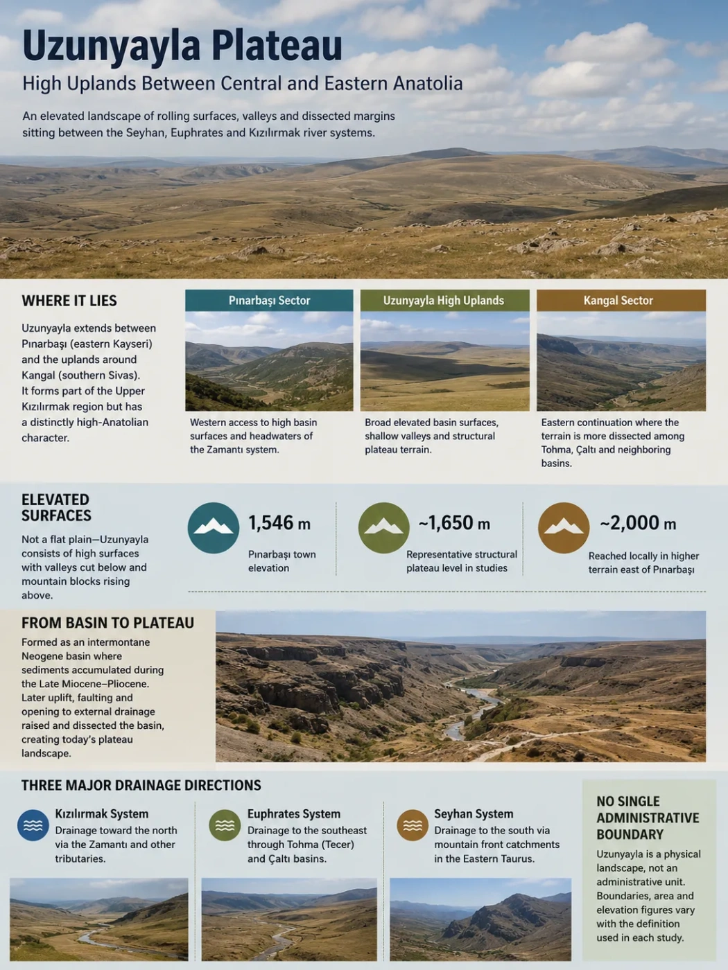
Uzunyayla is a broad high-upland system between eastern Kayseri and southern Sivas in Türkiye. Its surface commonly lies well above 1,500 metres, but it is not simply a flat tableland. It developed from a mountain-bounded Neogene basin that was later raised, opened to external drainage and cut by rivers. The result is an elevated landscape of rolling structural surfaces, valleys and increasingly dissected margins positioned near the divide between the Seyhan, Euphrates and Kızılırmak river systems.
Where Uzunyayla Sits in Anatolia
Uzunyayla occupies part of the high interior between Pınarbaşı in eastern Kayseri and the uplands around Kangal in southern Sivas. In traditional regional geography it belongs mainly to the Upper Kızılırmak section of Central Anatolia, yet its elevation, winter climate and eastward transition toward rougher terrain give it a distinctly high-Anatolian character.
Pınarbaşı provides a useful western reference point. The town stands at about 1,546 metres, while the Uzunyayla terrain extending eastward reaches much higher levels locally. Hınzır Mountain rises to the northeast of the Pınarbaşı sector, while the Tahtalı mountain system forms part of the high terrain to the south. Farther east, the plateau system connects with the Kangal Basin and adjoining dissected uplands.
Western access to the high basin surfaces and the headwaters of the Zamantı system.
Broad elevated basin surfaces, shallow valleys and structural plateau terrain.
Eastern continuation where the terrain becomes more strongly divided among Tohma, Çaltı and neighboring drainage basins.
Uzunyayla Does Not Have One Simple Administrative Boundary
The plateau is a physical landscape rather than an administrative unit. Geographic and geomorphological studies may use Uzunyayla for the western basin around the upper Zamantı, for a wider plateau extending toward Kangal, or for the broader Uzunyayla–Kangal basin system. Elevation, area and boundary figures therefore depend on which physical definition is being used.
A High Surface With More Than One Elevation
Uzunyayla is often described as lying roughly between 1,500 and 2,000 metres, but that range should not be treated as a perfectly level plateau floor. Official descriptions of the western part commonly place broad surfaces around 1,500–1,600 metres. Geomorphological studies of the Uzunyayla and Kangal basin sectors use values around 1,650 metres for major structural plateau surfaces, while terrain east of Pınarbaşı reaches approximately 2,000 metres in places.
Pınarbaşı town elevation
Representative structural plateau level in geomorphological studies
Reached locally in the higher terrain east of Pınarbaşı
The important feature is not a single average elevation but the existence of a large, already elevated interior surface. Valleys are cut below that surface and mountain blocks rise above it. This makes Uzunyayla very different from a low plain even where the horizon appears broad and nearly level.
How a Neogene Basin Became a Plateau
The present landform makes more sense when Uzunyayla is viewed first as an old basin and only later as a plateau. Geological and geomorphological work identifies the wider Uzunyayla–Kangal system as an important intermontane Neogene basin north of the Eastern Taurus mountain belt.
During the Late Miocene and Pliocene, the basin remained an area of sediment accumulation. Sedimentary deposits spread across the low-relief basin floor while surrounding mountain belts and fault structures controlled its setting. Studies of both the western Uzunyayla sector and the Kangal sector describe reverse faults and thrust-related boundaries around parts of the basin. In tectonic terminology, this type of mountain-bounded basin in a deforming orogenic belt can be described as a piggy-back basin.
Tectonic deformation created and maintained a high intermontane depression between surrounding uplands.
Lake and continental sediments accumulated across broad parts of the basin floor.
Continued deformation raised the basin system and increased its position relative to adjacent drainage.
Once external drainage developed, rivers began cutting into the basin fill and converting broad surfaces into dissected structural plateaus.
The transition to external drainage during the Quaternary is especially important. Rivers no longer merely occupied an internally accumulating basin; they began removing material from it. In the upper Zamantı sector, channels have cut tens of metres into Late Miocene–Pliocene basin deposits in places, leaving broad remnants of the former basin surface between valleys.
Why Uzunyayla Can Look Like Both a Plain and a Plateau
The central parts of Uzunyayla can appear surprisingly gentle. Broad surfaces have low local relief, and some valleys are shallow enough that the landscape resembles a rolling high plain. That appearance does not mean the area is an undissected plain.
River incision becomes more obvious toward many plateau margins. Valleys deepen, slopes become steeper and older basin surfaces are divided into separate upland blocks. The degree of dissection also changes from one sub-basin to another. The Kangal side contains more strongly dissected sectors, while parts of the upper Zamantı basin preserve extensive, weakly cut surfaces.
Horizontal or gently inclined sedimentary layers also influence the visible relief. Where erosion cuts these layers unevenly, structural benches and mesa-like remnants can develop. Such landforms are documented particularly within parts of the wider Kangal Basin. Uzunyayla is therefore better understood as a varied structural plateau system than as one continuous flat surface.
Why “Plateau” Still Fits
A plateau does not have to remain flat from edge to edge. Uzunyayla retains broad elevated surfaces inherited from an older basin floor, even though rivers have cut valleys through them. Its plateau identity comes from the regional high surface and its later dissection, not from perfect flatness.
A Headwater Region Dividing Three Major River Systems
Uzunyayla has an unusually clear watershed role. Water leaving different parts of the upland can enter three major Turkish river systems, eventually reaching different drainage regions. This hydrological position is one of the most useful ways to understand the plateau as a geographic unit.
The upper Zamantı rises in the Uzunyayla–Pınarbaşı area. It flows southward and ultimately becomes part of the Seyhan system draining toward the Mediterranean.
Drainage from the Kangal side enters the Tohma system and connects with the Euphrates basin.
Shorter north-flowing streams cross the watershed toward the Kızılırmak system, which drains to the Black Sea.
The divides between these systems are not always dramatic mountain crests. Across parts of a broad upland, modest changes in slope are enough to send neighboring streams toward completely different trunk rivers. Uzunyayla therefore functions as a high hydrographic divide as well as a plateau.
The eastern continuation becomes still more complex. The Kangal Basin is divided among the upper Tohma, upper Çaltı and other neighboring catchments. This drainage fragmentation helps explain why the eastern sector is more dissected and why a single simple boundary for the entire Uzunyayla system is difficult to draw.
Why the Climate Becomes More Eastern Across the Uplands
Uzunyayla lies far from maritime influence and at high elevation, producing long cold winters and comparatively mild summers. The climatic transition is particularly clear along the Pınarbaşı–Kangal direction.
Türkiye’s official 1991–2020 climate classifications place both Pınarbaşı and Kangal in the cold-winter, mild-summer category under the Trewartha system. The winter classification value is lower at Kangal than at Pınarbaşı, while their summer values are very similar. This supports the geographic impression that the plateau becomes more strongly associated with high eastern-interior conditions toward the Kangal side without undergoing a sudden climatic boundary.
| Station | Trewartha Winter | Trewartha Summer | De Martonne | Erinç |
|---|---|---|---|---|
| Pınarbaşı | Cold | Mild | Between semi-arid and humid | Semi-humid |
| Kangal | Cold | Mild | Between semi-arid and humid | Semi-humid |
Climate Classification Note
Different climate indices can assign different moisture labels to the same station because they use different formulas. The consistent signal around Uzunyayla is the combination of high continental elevation, cold winters, relatively mild summers and strong seasonal water limitation rather than one universal aridity label.
Elevation also shortens the warm season. Spring arrives later than on lower Central Anatolian plains, frost risk persists longer and autumn cooling begins early. These conditions help explain the extensive steppe cover and the long-standing importance of grazing.
Between Central and Eastern Anatolia Is a Transition, Not a Sharp Line
The phrase “between Central and Eastern Anatolia” describes Uzunyayla’s physical setting better than it describes an exact regional border. The western plateau around Pınarbaşı is tied geographically to the high eastern edge of Central Anatolia. Toward Kangal, the terrain meets a zone officially described as the junction between the Central Anatolian plains and the rougher land of Eastern Anatolia.
Western Uzunyayla
- Broad high basin surfaces are especially conspicuous.
- The upper Zamantı is the dominant drainage feature.
- Pınarbaşı is the principal geographic reference point.
- The landscape retains a strong connection with the Central Anatolian interior.
Toward Kangal
- Drainage divides become more complex.
- Dissected structural terrain becomes more prominent in several sectors.
- Cold high-interior climatic conditions remain strong.
- The landscape grades toward the more rugged uplands of eastern Anatolia.
This transition is gradual. There is no single ridge where a uniformly “Central Anatolian” landscape ends and an “Eastern Anatolian” one begins. Relief, drainage, altitude and climate change together across the high interior.
The wider geological context supports the same interpretation. Geological work has described the Uzunyayla basin as one of the easternmost major basins of the Central Anatolian interior, while its eastern continuation connects directly with Kangal and the upper Euphrates drainage network.
High Steppe Reflects the Elevation and Continental Climate
The open appearance of Uzunyayla follows directly from its physical setting. Cold winters, a relatively short growing season, summer moisture stress and extensive exposed upland surfaces favor steppe and grass-dominated vegetation. Continuous woodland is not a defining feature of the plateau interior.
Vegetation is not uniform, however. Valley bottoms and locations with better moisture can support denser plant growth than the exposed uplands. Soil depth also changes with slope and erosion. On dissected margins, thin soils and active runoff can restrict vegetation even where local precipitation is adequate.
The resulting landscape differs from both the lower, warmer dry plains farther west and the wetter high grasslands found in some parts of northeastern Anatolia. Uzunyayla is best treated as a cold continental high-steppe environment whose local character changes with elevation, drainage and exposure.
Grazing, Cultivation and Villages Follow the Landform
Land use mirrors the plateau’s physical geography. Open uplands provide extensive grazing ground, and provincial geographic descriptions have long associated Uzunyayla with sheep raising and horse breeding. Cultivation is more limited by cold conditions and the short growing season, although cereals such as wheat and barley are grown on suitable surfaces.
The relationship is not as simple as “high plateau equals no farming.” Parts of the wider Kangal sector contain broad cultivable surfaces, while valley floors and gentler slopes provide better soils and access to water. The most exposed or strongly dissected terrain is less favorable for intensive cultivation.
Settlement also responds to relief. The broad uplands have relatively low settlement density, while villages are more likely to occupy valleys, spring zones and locally sheltered terrain where water, cultivable ground and transport routes come together. Pınarbaşı developed as the main settlement reference on the western side of the plateau, close to important springs and the headwater zone of the Zamantı.
Uzunyayla Is More Specific Than the Anatolian Plateau
Uzunyayla should not be used as another name for the Anatolian Plateau or even for the whole Central Anatolian Plateau. Those terms describe much larger regional systems containing numerous basins, volcanic areas, plains and separate uplands.
Uzunyayla is a smaller named highland system with its own geomorphological identity: a Late Miocene–Pliocene intermontane basin transformed into elevated structural and dissected plateau terrain, centered on the Pınarbaşı–Kangal transition and positioned across major drainage divides.
| Feature | Uzunyayla | Broader Central Anatolian Plateau |
|---|---|---|
| Geographic scale | Regional high-upland and basin system | Much larger interior plateau region |
| Core landscape | High structural surfaces, intermontane basins and river-cut valleys | Multiple plains, basins, volcanic uplands and plateau surfaces |
| Characteristic elevation | Extensive terrain around and above 1,500 m | Broadly variable across the central interior |
| Hydrological identity | Near the divide between Seyhan, Euphrates and Kızılırmak drainage | Contains many separate internal and external drainage systems |
| Regional transition | Strong transition toward the colder eastern high interior | Extends across a much wider range of Central Anatolian environments |