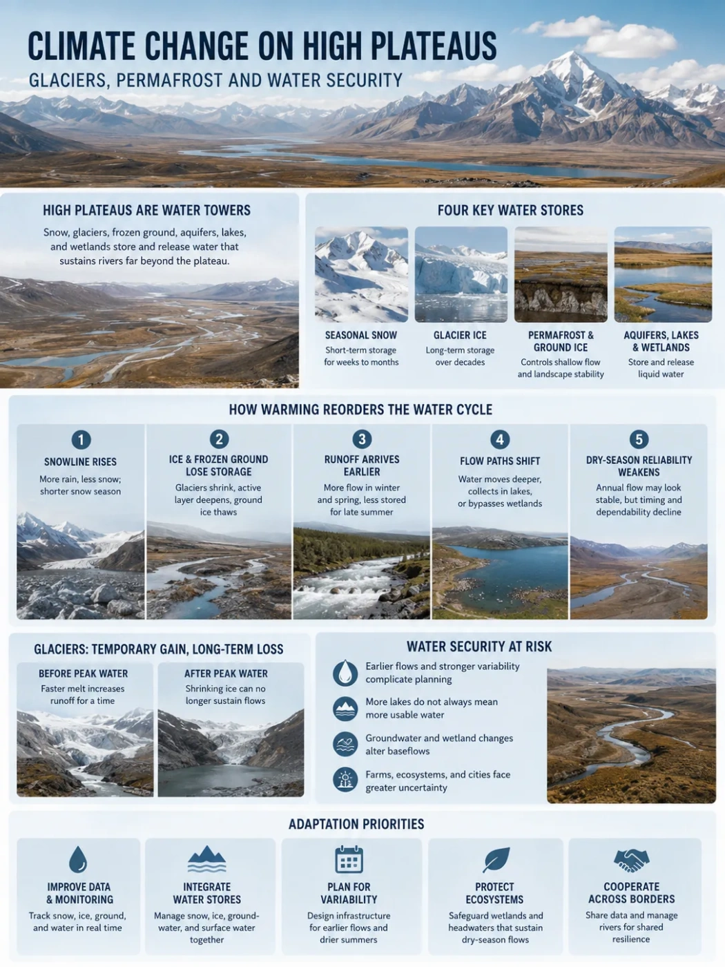
High-Plateau Cryosphere
High plateaus store water in glacier ice, seasonal snow, frozen ground, aquifers, lakes, and wetlands. Climate warming changes how these stores connect, shifting river flow across seasons and altering water security far beyond the plateau edge.
High plateaus are elevated headwater landscapes, but they do not work as simple reservoirs. Water moves between snow, glacier ice, ground ice, soil, aquifers, lakes, wetlands, and rivers. A warmer climate changes each store at a different speed. It can raise runoff for a time, reduce it later, move spring flow earlier, deepen groundwater paths, enlarge some lakes, drain others, and weaken the dry-season flow that farms and cities depend on.
Geography Note
A plateau can become wetter in its annual water balance while becoming less water-secure. More rain, larger lakes, or faster ice melt may still leave less usable water during the dry season, in the wrong basin, or too far from settlements and irrigation networks.
Four Water Stores Shape High-Plateau Rivers
The term cryosphere includes the frozen parts of the Earth system. On high plateaus, the most relevant parts are seasonal snow, glaciers, permafrost, seasonally frozen ground, lake ice, and river ice. These frozen stores interact with liquid water below and beside them, so glacier change cannot be understood in isolation.
| Water Store | Main Plateau Function | Typical Climate Response | Water-Security Effect |
|---|---|---|---|
| Seasonal snow | Stores winter precipitation for weeks or months | Shorter snow season, earlier melt, more rain instead of snow | Less spring and early-summer water; greater year-to-year variation |
| Glacier ice | Stores water across decades or longer | Faster melt followed by loss of ice area and volume | Temporary runoff gain before a later decline in glacier contribution |
| Permafrost and ground ice | Limits deep infiltration and guides shallow water flow | Warmer ground, deeper active layer, thaw settlement, new subsurface paths | Changes springs, wetlands, baseflow, lake drainage, and infrastructure stability |
| Aquifers, lakes, and wetlands | Store and release liquid water after snowmelt, rainfall, and thaw | Recharge may rise or fall by basin; evaporation and drainage can also change | Controls whether extra meltwater becomes usable supply, local flooding, or closed-basin storage |
These stores operate on different time scales. Snow is mostly an annual reserve, glaciers are long-lived reserves, and groundwater may retain water after the visible snow and ice have gone. Permafrost is different again: much of its water effect comes from controlling flow paths rather than supplying a large volume of meltwater directly.
How Warming Reorders the Plateau Water Cycle
The Snowline Rises
A larger share of precipitation falls as rain, and snow remains on the ground for less time.
Ice and Frozen Ground Lose Storage
Glaciers lose mass, the active layer above permafrost deepens, and ground ice begins to thaw.
Runoff Arrives Earlier
More water reaches streams in winter or spring, while less remains stored for late summer.
Flow Paths Shift
Water may enter deeper soil and rock, feed groundwater, collect in lakes, or bypass former wetlands.
Dry-Season Reliability Weakens
Annual flow may look stable even as the timing, location, and dependability of usable water change.
Elevation shapes every stage. High surfaces remain cold enough to hold snow and frozen ground, while steep plateau rims concentrate glaciers and feed outward-draining rivers. Lower interior basins may receive meltwater but have no outlet to the sea. Aspect, wind exposure, debris cover, slope, and local precipitation can make nearby catchments respond in different ways.
Glaciers Can Raise Runoff Before They Reduce It
When a glacier begins losing mass faster, it releases water that had been stored as ice. This can increase glacier runoff for years or decades. The temporary rise is often called the approach to peak water: the point at which annual glacier runoff reaches its highest level before the shrinking ice body can no longer sustain the same output.
Peak Water Is a Turning Point
Before peak water, faster melt can support irrigation, hydropower, reservoirs, and summer river flow. After the turning point, glacier contribution declines because the remaining ice surface and volume are smaller. The river does not necessarily disappear. Its flow becomes more dependent on rain, seasonal snow, groundwater, evaporation, and human withdrawals.
The timing of peak water is not uniform across a plateau region. Small, low, sunny glaciers may pass it earlier than large, high, shaded glaciers. A large river can also contain many tributaries at different stages, which can blur the turning point at the basin outlet.
Annual River Flow Can Hide the Loss
Annual totals do not show when water arrives. A basin may record similar yearly runoff while losing late-summer glacier flow and gaining winter rain or early spring snowmelt. That shift matters where crops, reservoirs, wetlands, or cities need water after the seasonal snow has already melted. Glacier effects are also strongest near glacierized headwaters and may become a smaller share of total flow farther downstream.
Current Field Record
For the 2025 glaciological year, all 23 monitored glaciers in High-Mountain Asia lost mass. The regional report linked the losses to below-average winter snow and above-average temperatures during the melt season. This is a dated observation from monitored sites, not a claim that every glacier in the region changed at the same rate.
Seasonal Snow Sets the Annual Water Budget
Glaciers receive more public attention, but seasonal snow often controls a larger share of yearly runoff across high plateaus and their surrounding mountains. Snow stores cold-season precipitation, protects soil from direct winter exposure, delays runoff, renews spring soil moisture, and supports groundwater recharge. A shorter snow season removes part of this timing function even where total precipitation does not fall.
Snow-to-Rain Change Moves Water into the Wrong Season
When a storm falls as rain rather than snow, more water can run off immediately. Winter and early-spring discharge may rise, while less water remains for the warm season. Rain falling on an existing snowpack can also produce rapid melt and high runoff, especially where frozen or saturated soils limit infiltration.
Repeated Low-Snow Years Create a Carry-Over Deficit
One poor snow year can reduce spring flow. Several in sequence can leave a deeper mark: soils begin the growing season drier, shallow aquifers receive less recharge, wetlands contract, and the next drought starts from a lower water-storage level. The effect carries across years even though the seasonal snow itself melts every year.
Dated Snow Record
In April 2026, snow persistence across the Hindu Kush Himalaya was reported at 27.8% below the long-term average, the fourth consecutive below-normal year. Ten of 12 monitored major basins were below normal, while the Mekong, Tarim, and Tibetan Plateau groupings recorded their lowest values in the 24-year record used for the update. Basin results should not be treated as a single uniform condition across all slopes and elevations.
Permafrost Regulates Water More Than It Supplies It
Permafrost is ground that remains at or below 0°C for at least two consecutive years. It may contain ice, but it is not simply an underground glacier. Its main hydrological role is often to act as a barrier that limits deep infiltration and directs water through the shallow layer that thaws each summer. This seasonally thawed zone is the active layer.
A Deeper Active Layer Opens New Routes
As the active layer deepens, water can move through a thicker volume of soil and broken rock. Some catchments gain deeper groundwater circulation and stronger cold-season baseflow. Others lose shallow water that once supported peatlands, alpine meadows, springs, or small streams. The outcome depends on slope, soil texture, bedrock fractures, permafrost continuity, and whether thaw creates a connected pathway to deeper aquifers.
Abrupt Permafrost Thaw and Retrogressive Thaw Slumps
Gradual permafrost degradation and abrupt thaw should not be treated as the same process. A deeper active layer means the seasonally thawed zone extends farther downward while the ground surface may remain broadly intact. Retrogressive thaw slumps (RTSs), by contrast, form when ice-rich permafrost thaws and the ground physically collapses or fails on a slope, exposing previously frozen sediment and reorganizing local drainage.
A 2026 Nature Communications study combined 4,728 mapped RTS incidents with 1,862 in-situ CO2 and CH4 measurements from RTS-affected areas across the Tibetan Plateau. The modelled area susceptible to RTS formation is projected to expand by about 17–19% by 2100 relative to 2022. In collapsed areas, CH4 release rates were about 20.0% higher than in control areas, while ecosystem respiration was 14.4% lower, showing that abrupt thaw does not shift every carbon flux in the same direction.
The study estimated that total CO2 and CH4 release associated with RTS expansion reached about 1.1 times the 2016 level by 2022. Under SSP2-4.5, projected annual RTS-related carbon release reaches 2.7 times the 2016 baseline by 2100. For plateau hydrology, the physical disturbance also matters: a slump can redirect shallow flow, expose wet sediment, increase erosion, and send sediment and dissolved material into nearby streams. That makes abrupt thaw a ground-failure process as well as a gradual loss of frozen storage.
Thaw Can Wet One Place and Dry Another
Ice-rich ground may collapse and form thermokarst depressions that collect water. Lakes can grow where the surface sinks. Yet lake water can also warm the ground below, create an unfrozen passage called a talik, and connect surface water to deeper groundwater. A lake may therefore expand for a period and later drain or lose water through a new subsurface route.
Permafrost Data Note
A 2026 model study estimated about 1.07 million km² of permafrost on the Tibetan Plateau for 2010–2023, excluding glaciers and lakes. It calculated warming at 15 m depth of about 0.11°C per decade since 1980 and an area decrease of roughly 12.4%. The study also found that shallow land models can misrepresent plateau permafrost because the active layer is often several metres deep. These figures are model estimates with stated uncertainty, not a surveyed boundary.
Ground-Ice Melt Is Not a Large Replacement Reservoir
Thaw releases water from ground ice, but the direct volume may be small compared with rainfall, snowmelt, and river flow. In the source region of the Yangtze River, one study estimated ground-ice meltwater release during 2016–2021 at about 4.3 mm per year, roughly 3% of the measured streamflow depth for the study period. The larger concern is often the way thaw changes routing, storage, surface stability, and seasonal discharge.
Expanding Lakes Do Not Always Mean More Usable Water
Many high plateaus contain closed basins. Water reaches a lake or salt flat but does not continue to the ocean. In these endorheic basins, more rainfall or meltwater can enlarge lakes without increasing river supply to lower regions. The new water may also be saline, remote from settlements, exposed to evaporation, or stored behind natural drainage barriers.
Closed Plateau Basins
- Water ends in lakes, marshes, or salt flats.
- Lake expansion may flood pasture, roads, and low ground.
- More stored water does not automatically mean more drinkable or irrigable water.
- Permafrost thaw can reorganize drainage within the basin.
Outward-Draining Basins
- Water leaves the plateau through major river systems.
- Changes can reach farms, reservoirs, and cities far downstream.
- Seasonal timing often matters more than annual volume.
- Groundwater may delay and smooth part of the response.
Groundwater Can Rise While Future Security Weakens
Groundwater offers an important buffer because it can sustain springs and river baseflow after surface snow has gone. Yet its response is uneven. A Tibetan Plateau study estimated a groundwater-storage increase of 3.51 ± 2.40 gigatonnes per year during 2002–2018, with much of the increase linked to glacier melt in outward-draining basins. The same study projected a slower rate of growth later in the century and possible losses in the headwaters of the Amu Darya, Yangtze, and Yellow River basins.
This is why a liquid-water gain can be misleading. If part of that gain comes from depletion of glacier ice, the recharge source is being reduced as it supplies the aquifer. Groundwater can delay the effect of glacier loss, but it cannot guarantee permanent replacement.
High-Plateau Regions Follow Different Water Paths
| Plateau Region | Dominant Cold-Region Stores | Main Hydrological Pattern | Water-Security Pressure |
|---|---|---|---|
| Tibetan–Qinghai Plateau and High-Mountain Asia | Widespread alpine permafrost, seasonal snow, glaciers along high ranges, many interior lakes | Mix of closed interior basins and major outward-draining headwaters | Earlier snowmelt, glacier loss, changing groundwater, thermokarst, and altered flow to large Asian river systems |
| Altiplano–Puna and Tropical Andes | Small glaciers, seasonal snow, mountain permafrost, rock glaciers, high wetlands | Strong wet–dry season contrast; local catchments and closed basins are common | Dry-season supply for high cities, pasture wetlands, irrigation, mining areas, and rural communities |
| Pamir–Tien Shan High Basins | Winter snow, valley glaciers, high-elevation frozen ground | Snow and glacier melt feed rivers crossing dry interior regions | Seasonal water for irrigation, reservoirs, hydropower, and downstream oases |
The Tibetan–Qinghai Plateau Has Several Water Systems, Not One
The plateau contains large lake basins with no ocean outlet, but its outer mountain belts also feed the Indus, Ganges, Brahmaputra, Mekong, Salween, Yangtze, Yellow, and other river systems. Water can rise in an interior lake while a distant headwater basin loses snow, groundwater, or late-season runoff. Treating the plateau as one reservoir hides this spatial contrast.
The Altiplano and Puna Depend on Small, Dispersed Stores
Across the dry Central Andes, water storage is spread among small glaciers, snowfields, rock glaciers, lakes, aquifers, and high-elevation wetlands known as bofedales. Small glaciers may contribute a modest share of annual basin flow but a much larger share during dry periods. Rock glaciers and ice-rich debris can also hold water where clean-ice glaciers are sparse, although their water volume and release rates remain difficult to measure.
Pamir and Tien Shan Rivers Carry Plateau Change into Dry Lowlands
In Central Asia, snow and glacier melt from high basins support rivers that cross much drier landscapes. The main risk is not only a lower annual total. Earlier melt, hotter summers, reservoir demand, and irrigation schedules can create a larger mismatch between supply and use. The basin scale matters because headwater change combines with evaporation, storage operations, and withdrawals farther downstream.
Water Security Has Five Separate Dimensions
Quantity
How Much Usable Water Remains
Glacier storage, snow water, aquifer recharge, evaporation, and withdrawals all affect the amount available.
Timing
When the Water Arrives
Earlier snowmelt may raise spring flow but leave less water during late summer.
Reliability
How Predictable Supply Is
Repeated low-snow years and erratic storms can widen differences between wet and dry years.
Quality
Whether the Water Can Be Used
Sediment, salinity, warmer streams, and dissolved material from thawing ground can raise treatment needs.
Access
Who Can Reach the Water
A larger remote lake does not help a village, farm, or city without a safe and affordable connection.
Water security declines when any one of these dimensions fails. A basin can have enough water on paper but still face shortages because the flow arrives before the irrigation season, becomes too variable for reservoir planning, or collects in a place where it cannot be used.
Hazards Often Rise During the Transition
Long-term water loss is only one part of the change. The period of rapid melting and thaw can increase floods, slope failures, sediment movement, and ground instability before a basin reaches its later, lower-ice condition. High plateau rims are especially exposed because steep valleys connect glaciers, lakes, roads, settlements, and river corridors.
Glacial Lake Outburst Floods
As a glacier retreats, meltwater may collect behind moraine debris or ice. A rockfall, ice fall, slope collapse, internal drainage change, or overtopping wave can release water suddenly. The resulting flood may entrain sediment and debris, increasing damage far below the lake. Retreating glaciers can therefore create a period of greater flood exposure even as long-term ice storage falls.
Permafrost Thaw and Slope Instability
Frozen water in soil and rock can help hold loose material together. Thaw may weaken steep slopes, widen cracks, and allow more water into unstable ground. Where ice-rich permafrost fails abruptly, retrogressive thaw slumps can expose sediment and move material downslope. On flatter plateau interiors, ice-rich soil can settle unevenly, deforming roads, embankments, pipelines, and building foundations.
Sediment Can Reduce Water-System Capacity
More erosion and slope movement can increase sediment in streams. Reservoirs lose storage as sediment accumulates, irrigation channels require more clearing, and drinking-water treatment becomes harder. The problem is therefore not limited to the amount of runoff; it also affects the infrastructure used to store and move that runoff.
Risk Sequence
Warming → faster melt and thaw → lake growth, ground settlement, and unstable slopes → higher flood and sediment risk → smaller long-term ice reserve. The hazard phase and the water-shortage phase can overlap rather than occur one after the other.
Different Users Depend on Different Parts of the Hydrograph
Plateau Pastoralism Depends on Shallow Water
High-elevation grazing systems often rely on small springs, wet meadows, ponds, and valley-bottom peatlands rather than large rivers. A deeper active layer can redirect shallow flow away from these sites. Even where basin runoff rises, a local pasture may dry if its near-surface water path changes.
Irrigated Agriculture Depends on Seasonal Alignment
Farm water demand usually rises after snowmelt begins. Earlier runoff can pass through a river system before crops need it unless reservoirs, aquifers, soils, or local storage retain the water. Late-summer glacier flow can be especially valuable during dry years because it arrives when rainfall and seasonal snow are limited.
Cities Depend on Storage and Treatment
High plateau cities and downstream urban areas may draw from reservoirs, rivers, springs, aquifers, or several sources at once. Glacier retreat can alter the balance among them. New lakes may not be suitable for supply, while deeper groundwater may cost more to pump and sediment-rich river water may cost more to treat.
Hydropower Depends on Flow Shape
Hydropower planning uses the seasonal pattern of discharge, not only the annual total. Earlier peaks, lower late-season flow, sediment loads, and larger year-to-year swings can reduce generation reliability or change when stored water must be released.
Wetlands Depend on Continuous Connection
High-elevation wetlands can smooth runoff, store carbon, support grazing, and provide habitat. Their persistence depends on repeated inputs from precipitation, groundwater, snow, and glacier melt. Research in the Peruvian Andes shows that wetlands near glaciers can have a steadier annual water supply than wetlands in recently deglaciated catchments, although local geology and groundwater remain important.
Indicators That Reveal the Direction of Change
No single measurement can describe high-plateau water security. Glacier length shows visible retreat, but it does not directly measure snow storage, groundwater recharge, dry-season flow, or whether a lake is expanding because of rainfall or melting ice.
| Indicator | What It Shows | What It Can Miss |
|---|---|---|
| Glacier mass balance | Annual gain or loss of glacier water equivalent | How meltwater is routed and used downstream |
| Glacier area and length | Changes in the visible ice boundary | Ice thickness and hidden loss under debris |
| Snow persistence | How long snow remains on the ground | Snow depth and water content without added measurements |
| Snow water equivalent | The amount of water stored in the snowpack | Local redistribution by wind between measurement points |
| Active-layer thickness | Depth of seasonal thaw above permafrost | Deep groundwater pathways and local ice content |
| Ground temperature | Whether permafrost is warming toward thaw | Exact surface-water response without hydrological data |
| Late-summer baseflow | Water available after snowmelt and rainfall peaks | Individual contributions from glacier, aquifer, and wetlands without tracers or models |
| Lake level and salinity | Change in liquid storage and water usability | The full source of lake gain or loss without basin accounting |
| Ground deformation | Thaw settlement, heave, and possible thermokarst activity | Water volume unless paired with field and subsurface data |
Satellite observations help map snow, glaciers, lake area, and surface deformation across remote plateaus. Field stations are still needed for snow depth, streamflow, borehole temperature, groundwater, water chemistry, and the ice content of frozen ground. Stable baselines and year-by-year datasets serve different purposes; a map designed to show maximum water extent, for example, should not be used as a record of annual lake change.
Adaptation Must Match the Physical Change
| Observed Change | Useful Response | Main Limitation |
|---|---|---|
| Earlier snowmelt | Seasonal forecasts, soil-water retention, revised irrigation timing, distributed storage | Storage cannot recover water already lost to evaporation or downstream passage |
| Lower late-summer flow | Demand management, aquifer protection, leakage control, drought allocation plans | Groundwater may recharge slowly or connect poorly to users |
| Glacial lake growth | Lake monitoring, valley warning systems, evacuation routes, selected drainage work | Risk changes as the glacier, lake, and slopes evolve |
| Permafrost thaw | Ground-temperature monitoring, flexible foundations, route relocation, drainage control | Thaw is spatially uneven and can continue below an apparently stable surface |
| Wetland drying | Protect recharge areas, reduce drainage, manage grazing pressure, restore local flow paths | Restoration cannot always replace a lost glacier or altered aquifer connection |
| Higher sediment loads | Catchment erosion control, sediment bypass, reservoir maintenance, treatment upgrades | Large slope failures can exceed normal design conditions |
Forecasting Must Move from Annual Totals to Seasonal Windows
Water planning needs forecasts for the periods when demand and ecological stress are highest. Useful questions include how much snow water remains before spring melt, whether a basin has passed peak water, how late-summer baseflow is changing, and whether thaw is connecting surface water to deeper groundwater.
Small Storage Can Be More Useful Than One Large Reservoir
Distributed ponds, managed aquifer recharge, restored wetlands, soil-moisture retention, and small reservoirs can hold water closer to plateau communities and farms. Large reservoirs may still be useful, but one structure rarely solves a mismatch spread across many headwater valleys and users.
Reservoirs Cannot Fully Replace Glaciers and Frozen Ground
A glacier stores water for long periods without a dam wall, pumping system, or operating schedule. It also releases part of that water during warm and dry conditions. Reservoirs can shift water between seasons, but they lose capacity to sediment, lose water to evaporation, occupy land, and depend on inflow that may itself become less reliable.
Permafrost is even harder to replace because its value is not limited to water volume. It controls where water can infiltrate, how deep it travels, when it reaches streams, and whether ground remains stable. A reservoir can store river water; it cannot recreate the former shallow flow network of a frozen plateau soil.
Landform Note
The plateau surface, surrounding ranges, escarpments, interior basins, and outlet valleys must be read as one system. Glaciers commonly sit on the highest rims, permafrost may cover broad interior uplands, and rivers transfer the combined signal into lower basins.
Where Measurement Is Still Thin
High plateaus are difficult places to monitor. Weather stations are sparse, glacier records often cover only selected sites, boreholes are expensive, and groundwater wells are rare. Short field records can also miss slow changes in deep permafrost and aquifers. These gaps make local certainty lower than the broad evidence for warming, glacier loss, snow change, and permafrost degradation.
- Debris-covered glaciers are hard to map because rock hides the ice and can either insulate it or increase melt where debris is thin.
- Rock glaciers may contain large stores of ice-rich debris, but estimates depend on uncertain thickness and ice content.
- Groundwater cannot be separated cleanly from other water stores by satellite gravity data without models and supporting observations.
- Small lakes and wetlands may change faster than coarse regional datasets can detect.
- Permafrost boundaries are three-dimensional thermal zones, not fixed lines that can be mapped from surface appearance alone.
For this reason, exact area, volume, or contribution figures should be tied to a period, basin definition, and method. A value for the whole Tibetan Plateau cannot be transferred directly to one tributary, and a glacier-fed headwater result cannot be applied unchanged to a distant river outlet.
Terms Used in High-Plateau Cryosphere Studies
Active Layer
The surface layer above permafrost that thaws during the warm season and freezes again during the cold season.
Baseflow
The part of streamflow supplied between storms and melt events, often by groundwater, springs, wetlands, or slow subsurface drainage.
Endorheic Basin
A closed drainage basin in which water ends in an inland lake, marsh, or salt flat rather than reaching the ocean.
Peak Water
The highest annual glacier runoff reached during glacier shrinkage, after which the smaller glacier supplies less meltwater.
Rock Glacier
A creeping body of rock debris that contains ice or ice-rich frozen sediment and may store water in dry high-mountain terrain.
Retrogressive Thaw Slump
An abrupt slope failure in ice-rich permafrost in which thawing ground collapses, exposing frozen sediment and allowing the slump headwall to retreat upslope.
Talik
A layer or zone of unfrozen ground within or beneath permafrost that can connect surface water with deeper groundwater.
Thermokarst
Uneven ground formed when ice-rich permafrost thaws and the surface settles, often creating pits, ponds, slumps, or altered drainage.