INTERACTIVE CONTEXT MAP
Where is Erzurum–Kars Plateau?
The selected plateau and nearby mapped locations are shown. Open the full world atlas to explore every region.
Eastern Anatolia · Volcanic High Uplands
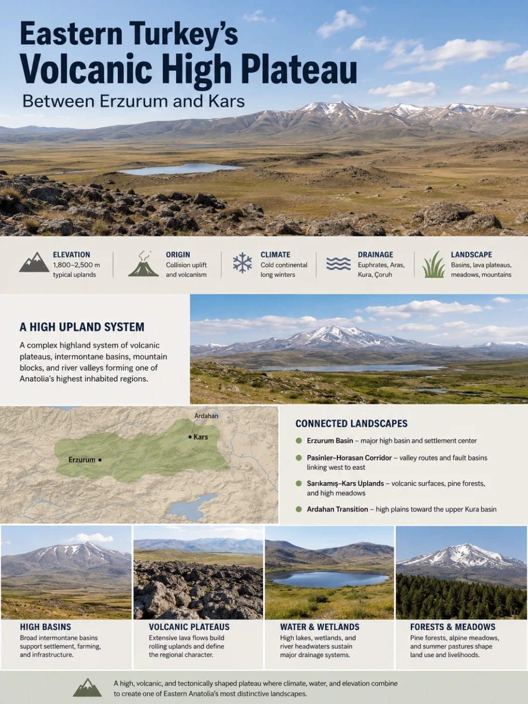
The Erzurum–Kars Plateau is a broad, cold highland system in northeastern Türkiye where tectonic uplift, thick volcanic cover, intermontane basins, long winters, and grass-based farming meet across one of Anatolia’s highest inhabited regions.
The Erzurum–Kars Plateau is not a single flat tableland with a sharp edge. It is better understood as a high-upland system: broad volcanic surfaces alternate with basins, mountain blocks, river corridors, wetlands, and locally forested slopes. The land remains high over a wide area, yet its local relief is varied enough to include the Erzurum Basin, the Pasinler–Horasan corridor, the Sarıkamış uplands, the Kars high plains, and the transition toward Ardahan.
| Profile Field | Erzurum–Kars Plateau |
|---|---|
| Name | Erzurum–Kars Plateau |
| Location | Northeastern Türkiye, mainly between Erzurum and Kars, with transitions toward Ardahan and the upper Aras and Kura regions |
| Landform Type | High volcanic and tectonic plateau system broken by intermontane basins, river valleys, mountain blocks, and lava-built uplands |
| Typical Elevation | Many settled basins and plains lie around 1,700–2,000 m; broad uplands commonly rise toward 2,000–2,500 m; surrounding summits exceed 3,000 m |
| Approximate Area | Not consistently reported because geological, geomorphological, and regional-geography boundaries do not match exactly |
| Geological Origin | Crustal shortening and uplift linked to continental collision, followed by widespread Miocene–Pliocene volcanism |
| Climate | Cold continental highland climate with severe winters, short mild summers, spring rainfall, and stronger early-summer rainfall toward Kars |
| Main River Connections | Karasu–Euphrates, Aras, Kars–Arpaçay, upper Kura, and headwater links toward the Çoruh basin |
| Known For | High grasslands, lava sheets, long snow seasons, livestock farming, Sarıkamış pine forests, high lakes, and major watershed divides |
Landform Note
The word plateau describes the broad regional elevation and raised surface. It does not mean that every part of the region is level. Basins, hills, mountains, and incised valleys can all sit within a larger plateau system.
Where the High Uplands Sit
The plateau occupies the northeastern part of Eastern Anatolia. Its western side is centered on Erzurum and the surrounding high basins. Eastward, the terrain passes through Pasinler and Horasan toward Sarıkamış and Kars. Farther north, the high volcanic country continues toward Ardahan, Çıldır, and the upper Kura basin.
Map Note
The map gives regional orientation between Erzurum and Kars. It does not show a surveyed plateau boundary. The plateau’s limits change depending on whether the term is used for a volcanic province, a geomorphological region, or a broader highland division of Eastern Anatolia.
Administrative borders do not define the landform. Erzurum Province includes terrain outside the plateau’s central volcanic uplands, while Kars Province includes high plains, depressions, mountain slopes, and river valleys. Ardahan is also treated in two ways: some regional accounts place it within the wider Erzurum–Kars highland belt, while others describe the Ardahan Plateau as a neighboring unit with its own drainage and topographic identity.
A Plateau Made of Several Landscapes
Travel from west to east reveals a sequence of linked but distinct terrain units. Their shared height and geological history connect them, but their local form, moisture, vegetation, and land use differ.
Western Basin
Erzurum Basin
A broad, high intermontane basin where settlement, roads, cultivation, and services concentrate. The basin floor is lower and flatter than many surrounding uplands, while mountain fronts rise sharply around it.
East–West Passage
Pasinler–Horasan Corridor
A chain of basins and valley routes that guides transport and links the Erzurum area with the upper Aras drainage. Fault-controlled depressions and river-cut surfaces are part of this corridor.
Volcanic Uplands
Sarıkamış–Kars Sector
Broad rolling surfaces, lava-built terrain, high meadows, and local pine forest distinguish this eastern sector. Summer rainfall remains more persistent than around Erzurum.
Northern Transition
Ardahan–Çıldır Highlands
Higher moisture, the upper Kura drainage, long snow cover, and volcanic terrain create a transition between the Erzurum–Kars uplands and the mountain systems near Georgia.
Erzurum Basin Is Not the Whole Plateau
Erzurum city stands on a high basin floor rather than on a uniformly exposed lava table. This distinction matters because basin floors collect sediment, channel rivers, and offer more continuous land for settlement and farming. Cold air can also pool in enclosed low areas, producing strong winter inversions even when nearby slopes are slightly warmer.
Kars Plain and Kars Plateau Are Not Always Used the Same Way
Local descriptions sometimes use “Kars Plateau” for a broad high plain or depression near Kars, while geological studies may use “Erzurum–Kars volcanic plateau” for a much larger volcanic province. The names overlap, but their scales differ. A city-level plain, a provincial highland, and a regional volcanic plateau should not be treated as identical landforms.
Why the Region Stands So High
The plateau belongs to the wider Eastern Anatolian high country created by long-term crustal shortening. As the Arabian Plate moved northward and collided with the Anatolian–Eurasian margin after the closure of branches of the Neotethys Ocean, the crust in Eastern Anatolia thickened and rose. This produced a broad elevated region rather than one narrow mountain chain.
Tectonic uplift raised the regional base level. Faulting and crustal deformation then divided the surface into mountain blocks, pull-apart basins, corridors, and local depressions. The plateau’s present form reflects both the regional rise of the crust and later reshaping by lava, rivers, erosion, and sediment accumulation.
Continental Collision Shortens the Crust
Northward plate movement compresses Eastern Anatolia. The crust thickens across a wide zone.
The Region Rises as a Broad Highland
Uplift raises basins, older surfaces, and mountain blocks to high elevations above surrounding regions.
Faults Open Routes for Magma
Strike-slip faults and local zones of extension allow magma to rise through fractures.
Lava and Pyroclastic Material Cover the Surface
Repeated eruptions spread lava sheets and volcanic deposits across large parts of the uplifted terrain.
Rivers and Basins Rework the Volcanic Surface
Streams cut valleys, sediment fills depressions, and weathering softens the original volcanic relief.
The Volcanic Foundation Beneath the Grasslands
Much of the plateau’s visible surface rests on collision-related volcanic rocks. Geological dating places the main studied volcanic sequence between about 11 million and 2.5 million years ago, with a strong phase between roughly 7 and 5 million years ago. Volcanic successions exceed 1 km in thickness in some places.
The volcanic record is not made of basalt alone. It includes compositions ranging from rhyolitic and other silica-rich pyroclastic material to intermediate lavas and broad olivine-bearing basaltic sheets. This range shows that the plateau formed through several volcanic phases rather than one eruption or one volcano.
Fissure Eruptions Helped Build Broad Surfaces
Many lava flows reached the surface through fractures associated with fault systems. Fluid lava spread laterally across older valleys and irregular ground. Repeated flows could bury local relief, connect separate surfaces, and create the wide, gently rolling uplands now associated with the Kars side of the plateau.
This process explains why a volcanic plateau can lack a dominant cone. Large volcanic mountains may rise nearby, but the plateau-forming material often came from multiple vents and fissures distributed across the region.
Volcanism Shifted Eastward
Age dating of volcanic units indicates a general west-to-east migration of activity through time. Younger phases also became more dominated by basic lava. That pattern helps explain why broad plateau-forming basaltic sheets are especially clear in eastern sectors.
Old Volcanic Terrain Does Not Mean an Active Eruption Field Everywhere
Volcanic Origin: The label describes how much of the surface formed. It does not mean that every hill is a volcano or that the whole plateau is an active volcanic hazard zone today.
Weathering, frost action, river incision, soil formation, and vegetation have altered the original lava surfaces. In many places, the volcanic base is now expressed through subdued rolling relief, dark soils, rocky breaks, resistant valley walls, and broad uplands rather than fresh lava fields.
Elevation Changes Over Short Distances
The plateau is often described in geological literature as a high surface near 2.5 km above sea level. In regional geography, however, many inhabited basins and plains are lower. Erzurum city lies at roughly 1,900 m, while Kars city is close to 1,750–1,800 m. Broad uplands rise beyond these basin floors, and surrounding mountain crests pass 3,000 m.
Elevation Note
There is no single elevation that represents the whole plateau. A practical description is about 1,800–2,500 m for many basin and upland surfaces, with lower river corridors and much higher mountain summits.
These differences shape daily temperature, snow duration, slope moisture, vegetation, and farming. A south-facing slope can lose snow earlier than a shaded basin edge. A high open meadow can remain cool and wind-exposed while a lower valley supports a longer growing season.
Why Kars Stays Greener Later Into Summer
The plateau has a cold continental climate, but the climate is not uniform from west to east. Erzurum and Kars both have very cold winters and mild summers. Kars is slightly colder in winter and receives more rainfall during early summer, which helps grasslands remain green longer.
| Published Station Measure | Erzurum | Kars | Geographic Meaning |
|---|---|---|---|
| January Mean Temperature | −9.1°C | −10.7°C | Kars has the colder midwinter mean |
| July Mean Temperature | 19.2°C | 17.6°C | Summer remains milder toward Kars |
| May Precipitation | 73.3 mm | 83.1 mm | Late spring is the wettest part of the year in both cities |
| June–July Precipitation | 77.0 mm | 133.7 mm | Early-summer moisture is much stronger at Kars |
| Approximate Annual Precipitation | 430.5 mm | 506.0 mm | Kars has a wetter grassland regime despite colder conditions |
The figures are published long-term station statistics for the two cities, not averages for every part of the plateau. Local elevation, slope direction, exposure, and distance from mountain barriers can produce marked differences.
Spring and Early Summer Matter More Than a Dry-Summer Label
Many inland parts of Türkiye dry sharply in summer. The Kars sector retains a stronger spring-to-early-summer rainfall pulse. Frequent showers and thunderstorms support meadow growth during the main grazing season. Around Erzurum, rainfall also peaks in spring, but July and August turn drier more quickly.
Snow Controls the Seasonal Calendar
Winter snow stores water on fields, pasture, and mountain slopes. Meltwater feeds streams, moistens soils, and supports early growing-season vegetation. Snow also delays access to high pastures, shortens construction and field-work seasons, and raises the need for winter fodder storage.
Wind can redistribute snow across open uplands. Exposed ridges may be stripped, while hollows, road cuts, and leeward slopes collect deep drifts. The result is a patchy melt pattern rather than one uniform snow line.
Regional Snow-Cover Signal: A study of Ardahan, on the northern side of the wider highland belt, found about a 6% decline in snow-cover percentage from 2000 to 2023 and a fall of roughly 20 frost days over a 63-year record. The finding should not be applied as one rate for the entire plateau, but it shows that the cold-season regime can change unevenly across the northeastern uplands.
A High Watershed Between Major Drainage Systems
The Erzurum–Kars highlands sit near several of Türkiye’s major watershed divides. Water from different parts of the plateau can ultimately reach the Persian Gulf, the Caspian Sea, or the Black Sea. This makes the region a headwater zone as well as a plateau.
Western Drainage
Karasu–Euphrates
Streams around Erzurum contribute to the Karasu, one of the main headwater branches of the Euphrates. High basins, mountain snow, and tributary valleys feed the system.
Eastern Drainage
Aras Basin
The Aras gathers water from the Pasinler–Horasan corridor and other eastern uplands before flowing toward the international Caspian basin.
Kars Sector
Kars River and Arpaçay
The Kars River and related tributaries drain broad grasslands and volcanic surfaces before joining the Arpaçay–Aras network.
Northern Uplands
Upper Kura
Near Ardahan and Çıldır, drainage turns toward the Kura system. This northern outlet separates part of the wider highland belt from the Aras-fed terrain farther south.
Northwestern Headwaters
Çoruh Connections
Some high mountain and plateau margins contribute to headwaters that descend toward the Çoruh basin and the Black Sea.
The plateau therefore acts as a water-divide landscape. A small change in ridge position can send runoff into a different continental drainage system. River incision also exposes volcanic layers along valley walls, making the drainage network useful for reading the region’s geology.
Lakes and Wetlands on the High Volcanic Surface
High lakes are scattered across depressions shaped by lava, faulting, basin development, and blocked drainage. Lake Çıldır, near the northern edge of the wider highland region, is the best-known example. Other lakes and wetlands are smaller, shallower, or more seasonal.
Lake basins differ in origin. Some occupy tectonic depressions. Others were affected by lava flows that altered older drainage. Shallow wetlands may form where fine sediment and low gradients slow runoff. Their water levels respond quickly to snowmelt, spring rain, evaporation, and local groundwater input.
- Lake Çıldır: A high freshwater lake linked to the Ardahan–Kars transition and the upper Kura drainage.
- Lake Aygır: One of several high volcanic-landscape lakes associated with the Kars uplands.
- Lake Kuyucuk: A shallow wetland basin whose ecological condition is sensitive to seasonal water balance.
- Small meadow wetlands: Poorly drained depressions that support wet grassland, nesting habitat, and local hay production.
These waters are not isolated features. They form part of a wider snowmelt, stream, soil-moisture, and groundwater system. A dry spring can affect pasture and shallow lakes at the same time.
Grassland Dominance and the Sarıkamış Forest Exception
The plateau is widely known for open grasslands, but “steppe” alone is too broad a label. Vegetation changes with moisture, elevation, slope direction, snow persistence, soil depth, and grazing pressure.
High Meadows and Mown Grassland
Moister basins and uplands support dense meadow vegetation. These areas are used for summer grazing or cut for hay. The timing of growth follows snowmelt and spring rainfall, while the stronger early-summer rain around Kars helps extend the green season.
Drier Steppe Surfaces
More exposed and less humid areas carry shorter grass and steppe plants. Soil depth may be limited on eroded slopes or rocky lava surfaces. Repeated grazing can lower plant cover where stocking and recovery periods are not balanced.
Subalpine and Alpine Vegetation
Above the main farming and settlement zone, colder slopes support high-mountain plant communities. Snowbeds, moist hollows, wind-exposed ridges, and rocky ground create small habitat zones over short distances.
Sarıkamış Pine Forests
The Scots pine forests around Sarıkamış show that the plateau is not entirely treeless. Forest survives where elevation, moisture, slope exposure, soil, and local climate allow it. These woodlands create a clear contrast with nearby open meadows and lava uplands.
Soils: More Varied Than the Chernozem Label
Dark, organic-rich grassland soils are often associated with the Erzurum–Kars region. They develop where dense roots add organic matter to the upper soil and where moisture supports sustained grass growth. Yet the whole plateau is not covered by one soil type.
| Terrain Setting | Common Soil Character | Main Limitation or Use |
|---|---|---|
| Moist grassland uplands | Dark, humus-rich meadow or chernozem-like topsoil | Good pasture and hay value; short growing season remains a limit |
| Volcanic slopes and rocky surfaces | Shallow, stony soils over lava or pyroclastic material | Erosion risk, limited cultivation, grazing use |
| Basin floors and river terraces | Alluvial and mixed sediment soils | More suitable for crops where drainage and frost conditions allow |
| Poorly drained hollows | Wet meadow and hydromorphic soils | Hay, wetland habitat, seasonal waterlogging |
| High exposed ridges | Thin cold-climate soils with slow development | Low plant cover and strong frost weathering |
Volcanic parent material can supply minerals, but fertility depends on much more than bedrock. Soil depth, drainage, organic matter, slope, erosion, temperature, and the length of the growing season often control land use more directly.
Why Livestock Farming Fits the Plateau
The natural economy of the highlands follows the seasonal rhythm of grass. Long winters and frost restrict many crops, while broad meadows and pastures support cattle and sheep during the warmer months. Barley, wheat, and fodder crops fit the climate better than heat-demanding crops.
The annual cycle is tightly organized:
- Late winter and early spring: Livestock remain dependent on stored hay and feed while snow still covers pasture.
- Spring thaw: Lower meadows green first, but wet ground can delay grazing and machinery.
- Early summer: Herds move onto wider pasture as grass growth reaches its strongest period.
- Mid- to late summer: Hay is cut and stored; grazing shifts according to moisture and pasture condition.
- Autumn: Frost ends much of the growing season, and livestock return toward winter shelter and stored feed.
Recent provincial figures show how closely land use follows this geography. Kars reported that grassland and pasture covered about 44% of the province and that the combined cattle and small-livestock population was around 1.5 million in 2025. Erzurum’s 2025 agricultural briefing listed about 15.0 million decares of meadow and pasture, equal to roughly 61% of provincial land. These are province-wide figures, so they include terrain beyond the strict geomorphological plateau boundary.
Pasture Is Productive but Not Unlimited
Short summers create rapid grass growth, but they also leave limited recovery time. Early turnout, repeated grazing, trampling near water, and insufficient rest can thin plant cover. On sloping or shallow soils, reduced cover allows more runoff and erosion.
Hay production is therefore as important as open grazing. Winter survival depends on summer storage, and villages often use different meadow types for cutting and grazing rather than treating all grassland the same way.
Settlement and Transport Follow Basins and Corridors
High elevation does not prevent settlement, but it directs where settlement is easiest. Towns and villages cluster on basin margins, valley floors, lower slopes, and transport corridors where land is flatter, water is available, and snow clearance is more manageable.
Why Basin Edges Attract Settlements
Basin floors offer broad land, but they can be wet, flood-prone, or exposed to cold-air pooling. Slightly raised margins often give better drainage and protection while remaining close to fields and water. This pattern appears around many highland settlements.
The Erzurum–Pasinler–Horasan Route
The east–west corridor through Erzurum, Pasinler, and Horasan provides one of the main passages across the high country. Valleys and basins reduce the need to cross every mountain ridge. They also guide roads, railways, settlements, and river systems through the plateau.
Winter Changes Distance
A route that appears short on a map can become difficult under drifting snow, black ice, or low visibility. Open uplands are exposed to wind, while passes and road cuts collect snow. Freeze–thaw cycles also damage pavement and unprotected structures.
Traditional building practice reflects these conditions through compact settlement form, thick masonry, protected entrances, storage space, and a strong need for winter fuel and fodder. Modern materials have changed building styles, but the thermal and logistical demands of the plateau remain.
How the Plateau Differs From Central Anatolian Plateaus
Erzurum–Kars Plateau
- Common upland elevations near or above 2,000 m
- Long, severe winters and a short growing season
- Widespread collision-related lava and pyroclastic cover
- Spring and early-summer rain supports broad meadows
- Livestock, pasture, and hay are central to rural land use
- Several major drainage systems begin or divide across the region
Many Central Anatolian Plateaus
- Generally lower regional surfaces
- Hotter, drier summers and less persistent snow
- More varied origins, including sedimentary, erosional, and volcanic terrain
- Summer dryness is usually stronger
- Dry farming and cereal production often occupy a larger share of open land
- Large closed basins are more widespread in some sectors
The clearest difference is the combination of very high elevation, cold-season length, and summer grass moisture. Central Anatolian plateaus can also be volcanic or cold, but few combine these traits across such a broad inhabited upland.
Natural Hazards and Surface Change
The same processes that created the plateau continue to affect its surface. Eastern Anatolia remains tectonically active, so earthquake risk belongs to the regional setting. Fault-controlled basins and valleys are part of the landscape’s origin, though local hazard varies by fault position, ground type, and construction quality.
- Earthquakes: Active deformation affects the wider Eastern Anatolian region. Soft basin sediment can behave differently from firm volcanic bedrock during shaking.
- Snowdrift and blizzard conditions: Open uplands allow strong wind transport of snow, especially near roads, passes, and exposed settlements.
- Avalanches: The broad plateau surface itself is often gentle, but steep mountain slopes and confined valleys can hold avalanche terrain.
- Freeze–thaw damage: Repeated freezing expands water in cracks, breaks rock, and weakens roads, walls, and slope cuts.
- Spring flooding: Rapid snowmelt and rain can raise streams across basin floors and narrow valleys.
- Pasture erosion: Thin vegetation, trampling, and concentrated runoff can expose soil on slopes and heavily used grazing routes.
- Wetland contraction: Shallow lakes and meadow wetlands respond quickly to changes in snowmelt, rainfall, drainage, and water use.
Cold-climate weathering is especially visible where exposed volcanic rock breaks into angular fragments. In flatter areas, finer material moves downslope or collects in basins. Over time, this slow transfer helps turn rugged volcanic surfaces into rolling uplands, soil-covered meadows, and sediment-filled depressions.