INTERACTIVE CONTEXT MAP
Where is Bié Plateau?
The selected plateau and nearby mapped locations are shown. Open the full world atlas to explore every region.
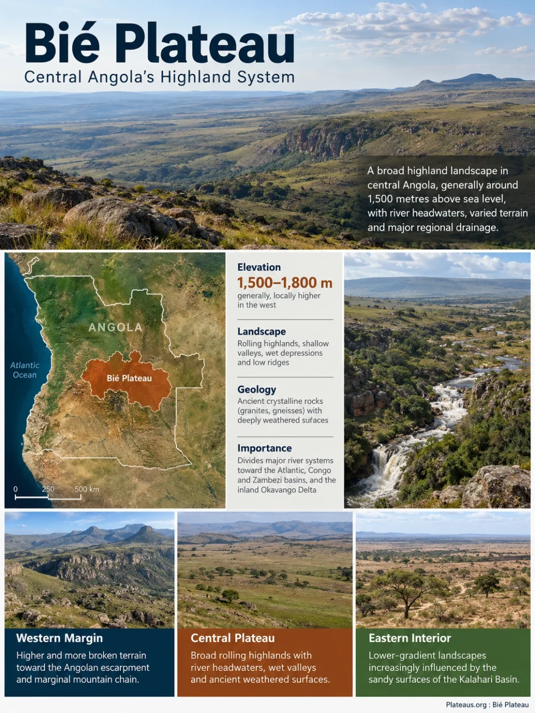
The Bié Plateau is a broad highland system in central Angola, generally around 1,500 metres above sea level and locally higher toward the western highlands. Its defining geographic role is drainage: rivers leave this elevated interior toward the Atlantic Ocean, the Congo and Zambezi basins, and the inland Okavango Delta. Wet valleys, deeply weathered soils, miombo woodland, grasslands and peat-forming headwaters make the plateau far more varied than a flat elevated surface.
Bié Is a Highland System, Not a Province-Shaped Tableland
The name Bié Plateau, also encountered as the Central Bié Plateau or as part of Angola’s Central Plateau, refers to a physical landscape rather than an administrative unit. It should not be treated as if its boundary follows the outline of Bié Province. The wider central highland landscape extends through parts of several provinces and grades into other plateau, mountain and peneplain units.
Much of the terrain is elevated but gently rolling. Broad uplands alternate with shallow valleys, wet depressions, river corridors and low ridges. Granitic residual hills occur locally. This produces a landscape that can appear almost level over long distances while still containing enough relief to divide some of southern Africa’s largest drainage systems.
Higher and more broken terrain toward the Angolan escarpment and marginal mountain chain.
Broad rolling highlands with river headwaters, wet valleys and ancient weathered surfaces.
Lower-gradient landscapes increasingly influenced by the sandy surfaces of the Kalahari Basin.
The elevation is therefore better expressed as a range and landscape pattern than as one number. Older regional classifications describe the ancient central plateau as descending from roughly 1,800 m in the west toward about 1,400 m in central Angola. Other descriptions of the central highlands commonly place much of the elevated terrain around 1,500–1,800 m.
Boundary Note
There is no single universally used polygon for the Bié Plateau. “Bié Plateau,” “Central Plateau,” “Angolan Highlands” and “Angolan Highlands Water Tower” overlap in geographic discussion but do not describe identical boundaries.
Old Crystalline Rocks Underlie a Deeply Weathered Plateau Surface
The plateau belongs to Angola’s old continental interior rather than to a young volcanic tableland. Large parts of the western and central highlands are associated with Precambrian crystalline basement, including granites, gneisses and related metamorphic rocks. Long periods of weathering and erosion have reduced much of this old terrain to broad surfaces rather than continuous mountain ridges.
The result is a mixture of gently rolling uplands, low ridges, shallow depressions and scattered resistant rock masses. River incision has broken the surface locally, but broad interfluves remain. This is why the Bié landscape can function simultaneously as a plateau and as a major watershed.
Ancient granitic, gneissic and related rocks form much of the underlying structure of central and western highland terrain.
Tropical weathering altered the upper rock layers and helped produce thick, iron-rich soils across many better-drained surfaces.
Streams cut valleys through the old surface while broad uplands remained between drainage lines.
The highest mountains west of the plateau should be kept separate from the plateau surface itself. Mount Moco, at 2,620 m, belongs to Angola’s western marginal mountain chain. Using it simply as the “highest point of the Bié Plateau” blurs the distinction between the broad ancient plateau and the higher mountain belt along its western margin.
The Plateau Is One of Angola’s Main Continental Drainage Divides
Elevation alone does not explain the geographic importance of the Bié Plateau. Its position near major watershed divides means that rain falling on different sides of the highlands can begin journeys toward very different destinations.
Some rivers descend westward through Angola and reach the Atlantic. Others enter the Congo or Zambezi drainage systems. The Cubango and Cuito move south and southeast into the Okavango system, which does not reach the sea at all.
| Drainage System | Highland Connection | Downstream Destination |
|---|---|---|
| Cuanza | Headwaters in central Angolan highlands associated with the Bié Plateau | Atlantic Ocean |
| Cunene | Begins in the central highlands and flows south before turning west | Atlantic Ocean |
| Cubango–Okavango | Cubango and Cuito headwaters rise in the elevated Angolan interior | Okavango Delta in Botswana |
| Congo Basin | Northern drainage enters tributary systems connected to the Kasai and Congo | Atlantic Ocean through the Congo River |
| Upper Zambezi | Eastern highland rivers and wetlands contribute to the upper basin | Indian Ocean through the Zambezi system |
Seasonal rainfall is collected across broad uplands, source wetlands and shallow valleys.
Small differences in position determine whether water moves west, north, east or southeast.
The resulting drainage reaches the Atlantic, the Zambezi system or the inland Okavango Delta.
This drainage geometry gives the plateau an unusual continental role. Water originating within the same broad highland region can eventually enter both the Atlantic and Indian Ocean drainage networks, while another portion ends in an inland delta hundreds of kilometres from the sea.
The Angolan Highlands Water Tower Is a Hydrologic Subset of the Plateau
Modern hydrological research has introduced a more precise boundary inside the wider central highlands: the Angolan Highlands Water Tower, often abbreviated AHWT. This is not another name for the entire Bié Plateau.
The hydrological boundary was defined using terrain and rainfall patterns within the Central Bié Plateau. Areas above 1,274 m were used to delineate an approximately 380,382 km² water-tower region. The threshold reflects the relationship between elevation and the distribution of precipitation across major headwater catchments rather than a conventional geomorphological border.
Hydrological Elevation Criterion
The elevation threshold used to define the Angolan Highlands Water Tower within the central highlands.
Defined Water-Tower Area
Approximate area enclosed by the hydrological definition, not a measured area of the entire Bié Plateau.
Mean Annual Precipitation
Average precipitation calculated across the defined water tower for 1981–2021.
Mean Gross Precipitation Volume
Estimated annual precipitation volume falling over the defined water-tower area during the same period.
Do Not Use 380,382 km² as the Area of the Bié Plateau
The figure measures the hydrologically defined Angolan Highlands Water Tower. The physical Bié Plateau has less uniform boundaries in geographic literature, so assigning the water-tower area directly to the plateau would create false precision.
The defined water tower intersects numerous catchments, including several that cross national borders. Its importance therefore comes from both elevation and area: a very broad upland receives seasonal rainfall and distributes that water into river systems extending far beyond central Angola.
Seasonal Rainfall Is Stored and Released Through the Headwaters
Rainfall across the Angolan Highlands is strongly seasonal. Most rain falls from roughly September or October through April, with the wetter part of the season centred on the austral summer. The elevated terrain is cooler than Angola’s low coastal regions, and cold dry-season nights can occur across the higher central interior.
The hydrology does not behave like water running immediately off a steep mountain. Broad valleys, sandy deposits, wetlands and peat-forming areas can slow the transfer of water through the landscape. Some water moves rapidly through channels, while some remains in wet valley floors or enters shallow groundwater before returning gradually to streams.
This storage helps explain why the plateau functions as more than a collection of river sources. The landscape can maintain flow after individual rain events have ended, especially in headwater systems with extensive wetlands.
The Okavango Flood Begins in Angola Months Before Its Botswana Peak
The Cubango and Cuito rivers provide one of the clearest examples of the plateau’s long-distance hydrology. They collect water in the Angolan Highlands before joining the river system that becomes the Okavango and enters northern Botswana.
More than 95% of the water flowing into the Okavango Delta has been estimated to originate from precipitation in the Angolan Highlands. The delta itself lies in a much drier environment, so its annual flood depends heavily on water generated far upstream.
Wet-season precipitation feeds source streams, wetlands and groundwater in elevated catchments.
The main headwater systems carry water southward through Angola toward Namibia and Botswana.
Slow river travel, wetland storage and movement through the delta delay peak inundation until the regional dry season.
The river spreads across an inland alluvial fan rather than continuing to an ocean.
This delay creates an unusual seasonal pattern. Rain falls in the Angolan headwaters during the wet season, but the largest flooded area in the Okavango Delta normally occurs months later. The distance from the headwaters, slow downstream movement and temporary storage within wetlands all contribute to the lag.
The Cuito and Cubango also behave differently. The Cuito drains terrain with extensive sands and wetlands that can moderate runoff and sustain slower release. Parts of the Cubango system have steeper gradients and a more direct channel response. Treating the two headwaters as hydrologically identical hides an important part of how the Okavango flood pulse is produced.
Peatlands Occupy More of the Water Tower Than Earlier Mapping Showed
Peat has become one of the most informative recent discoveries in the highland drainage system. Peat develops where waterlogged conditions slow the decomposition of plant material, allowing organic matter to accumulate. In the Angolan Highlands, peat occurs in settings that include river valleys, floodplains, terraces and source-lake environments.
A 2026 regional mapping study estimated 8,662–11,167 km² of potential peatland across the Angolan Highlands Water Tower. The range represents approximately 2.28–2.94% of the defined water-tower area. The model was checked against 51 peat locations verified in the field during expeditions conducted between 2019 and 2023.
Higher-certainty potential peatland estimate
Broader lower-certainty estimate
Ground-verified peat locations used to evaluate the model
An earlier mapping study estimated about 1,634 km² of peat within a study area of roughly 61,590 km². The newer 2026 estimate should not be presented as a simple several-fold increase in the same measured peatland area. The newer work covers the much larger 380,382 km² Angolan Highlands Water Tower and uses a different mapping approach.
Why the Two Peat Estimates Are Not Directly Comparable
The earlier estimate mapped a much smaller geographic study area. The 2026 work extends modelling across the full hydrologically defined water tower. The difference therefore reflects expanded coverage and methodology as well as newly mapped potential peat.
Radiocarbon measurements from earlier peat research also show that these deposits did not all form at the same time. Some riparian peat initiation dates reach back roughly 7,100 calibrated years before present, while another group began much more recently. River movement, terrace formation and persistent waterlogging influence where peat can accumulate.
Miombo Uplands and Wet Grasslands Form a Topographic Mosaic
Vegetation across the central highlands changes with drainage, soil and elevation. Better-drained surfaces commonly support miombo woodland, dominated regionally by trees such as Brachystegia and Julbernardia. Waterlogged valley floors can remain much more open, forming grasslands, dambos and wetland corridors.
Better-Drained Uplands
Miombo woodland and wooded savanna occupy many surfaces where soils remain aerated for most of the year.
Seasonally Wet Valleys
Shallow depressions and drainage corridors can support open grassland where saturated soils limit ordinary tree growth.
Peat-Forming Sites
Persistent wetness in selected valley, floodplain, terrace and source environments allows organic material to accumulate as peat.
The landscape can therefore change sharply over a short horizontal distance. A wooded upland may descend into an open grassy valley even though the regional climate is the same. Local water-table depth and soil drainage can matter as much as rainfall.
Some Grasslands Hide Woody Plants Below the Surface
One of the more unusual vegetation forms associated with the Bié and central Angolan highlands is geoxylic grassland. These landscapes can look almost treeless above ground while containing plants with large woody structures below the soil surface.
Such plants are often called geoxyles or, less formally, “underground trees.” Their protected underground stems and woody organs allow them to resprout after disturbance. This growth form is associated with environmental pressures that include seasonal fire, cold dry-season nights, nutrient-poor soils and local waterlogging.
Grasses, herbs and relatively short seasonal shoots dominate the visible surface.
Woody stems, root systems and storage structures remain protected beneath the soil.
These grasslands are especially useful for understanding why vegetation cannot be inferred from rainfall alone. A high-rainfall tropical upland does not automatically become tall forest. Soil chemistry, drainage, frost and repeated fire can maintain open vegetation even where enough rain falls to support woodland nearby.
Deeply Weathered Soils Are Often Nutrient-Poor
The green appearance of the central Angolan highlands can create the impression of uniformly fertile soil, but much of the plateau has been weathered for a very long time. Ferralsols are widespread across western and central plateau surfaces, while sandy Arenosols become more extensive farther east where Kalahari sands cover older geological formations.
Ferralsols form under prolonged chemical weathering. Heavy leaching removes many readily available nutrients, while iron and aluminium oxides help produce the characteristic reddish colours of many upland soils. Harder ferricrete or lateritic horizons can occur within some profiles.
Kalahari sands present a different limitation. Their quartz-rich texture commonly provides little mineral nutrition and relatively low water-holding capacity. Valley bottoms may contain alluvial, hydromorphic or organic-rich soils that behave very differently from surrounding uplands.
| Setting | Common Material or Soil Character | Landscape Effect |
|---|---|---|
| Western and central uplands | Deeply weathered ferrallitic soils over crystalline rocks | Broad reddish uplands that may be strongly leached |
| Eastern plateau and peneplain | Quartz-rich Kalahari sands and Arenosols | Sandy surfaces with low natural nutrient reserves |
| Wet valleys | Alluvial, hydromorphic and locally organic-rich deposits | Seasonal saturation, grassland, wetlands and peat formation |
Agriculture is widespread in parts of the highlands, but agricultural use should not be taken as evidence that the plateau is naturally covered by rich soils. Soil fertility varies sharply with parent material, drainage, erosion and land management.
New Zambezi Measurements Show How Far the Highland Influence Extends
The eastern drainage of the Angolan Highlands is receiving closer hydrological study. Measurements reported in 2025 examined the Upper Zambezi and Lungwebungu systems and found a large Angolan contribution during one late wet-season survey period.
For March through May 2023, researchers estimated that the Angolan portions of the Upper Zambezi and Lungwebungu sub-basins supplied about 73% of the flow measured upstream of the Barotse Floodplain. The result is valuable because it directly measures the importance of Angola’s headwaters to this part of the Zambezi system.
How to Read the 73% Figure
The value is a preliminary estimate for measurements made during the late wet season of 2023. It is not a fixed annual percentage and should not be applied to every season or year.
The same research identified extensive wetland coverage in the Angolan Upper Zambezi sub-basin, including the Kameia and Luena wetland systems. This reinforces the wider pattern seen across the central highlands: broad wet headwaters can influence river flow far downstream without resembling steep mountain source valleys.
Bié Plateau Should Be Kept Separate From Angola’s Western Mountain Belt
Several elevated landscapes meet in central and western Angola, and their names are sometimes merged too loosely. Distinguishing them makes the physical geography easier to interpret.
| Landscape Unit | General Position | Physical Character |
|---|---|---|
| Bié / Central Plateau | Central Angolan interior | Broad rolling highland and major headwater region |
| Marginal Mountain Chain | Western edge of the interior plateau | Higher residual mountain terrain including Angola’s highest peaks |
| Upper Cuanza Basin | North and northeast of parts of the central highlands | Slow-draining upper catchment with extensive seasonal wetlands |
| Eastern Peneplains | East of the higher central terrain | Gentler surfaces increasingly covered by Kalahari sands |
| Angolan Highlands Water Tower | Hydrologically defined area within and beyond parts of the central highland landscape | Research boundary based on elevation and headwater precipitation rather than a traditional landform boundary |
The Bié Plateau is therefore most accurately understood as a broad central Angolan highland and watershed landscape, not as a sharply bounded mesa or a mountain summit region. Its rolling uplands, weathered surfaces, wet valleys and branching drainage divides explain why rivers beginning close to one another can eventually reach the Atlantic, the Zambezi system or the landlocked Okavango Delta.