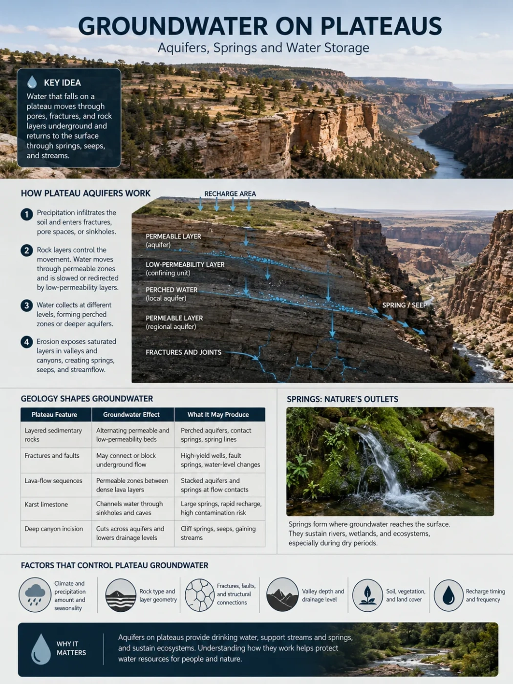
Plateau Hydrogeology
Groundwater beneath a plateau does not sit in one vast underground lake. It moves through pores, fractures, lava-flow contacts, caves, and weathered rock, then returns to the surface through springs, seeps, canyon walls, wetlands, and river channels.
A plateau may receive rain or snow across a broad elevated surface, yet elevation alone does not make it rich in usable groundwater. The amount of water below the surface depends on rock type, fracture networks, layer geometry, recharge timing, and the depth of valleys that cut into the plateau. Two plateaus with similar climates can therefore have very different wells, springs, and dry-season streamflow.
Landform Note
A plateau is defined by its surface form and position above nearby land. An aquifer is a rock or sediment unit that stores and transmits enough groundwater to feed wells, springs, or streams. A plateau can contain several aquifers, weak water-bearing layers, and dry rock zones at the same time.
A Plateau Is a Landform, Not a Water Tank
The flat or rolling surface of a plateau can create a broad recharge area. Water that enters the ground at high elevation also gains hydraulic head, allowing it to move toward lower slopes, escarpments, valleys, and basins. The plateau shape sets the broad direction of movement, while the geology controls where the water can enter, how long it remains underground, and where it can emerge.
Groundwater usually fills small spaces rather than open underground chambers. In sandstone it may occupy pores between grains. In limestone it can move through enlarged joints and caves. In basalt it often follows broken zones between separate lava flows. In granite or metamorphic rock, most usable water may lie in weathered material and connected fractures.
| Plateau Feature | Groundwater Effect | What It May Produce |
|---|---|---|
| Broad, gently sloping summit | Spreads rainfall and snowmelt across a large possible recharge area | Diffuse infiltration, shallow water tables, or many small recharge points |
| Layered sedimentary rocks | Creates alternating water-bearing and low-permeability beds | Perched aquifers, contact springs, and spring lines on escarpments |
| Deep canyon incision | Cuts across aquifers and lowers nearby drainage levels | Cliff springs, seeps, gaining streams, and separated groundwater compartments |
| Faults and joints | May connect layers or block flow where fractures are sealed | High-yield wells, fault springs, or abrupt changes in water level |
| Lava-flow sequence | Places permeable flow tops and rubble zones between denser basalt interiors | Stacked volcanic aquifers and springs at flow contacts |
| Karst surface | Funnels water into sinkholes, fissures, and underground channels | Large springs, rapid recharge, and high contamination sensitivity |
Reading the Hidden Cross-Section Beneath a Plateau
A useful way to understand plateau groundwater is to picture a cross-section from the summit to a canyon floor. Rain or melting snow enters at the top, moves downward through soil and weathered rock, and then follows the paths allowed by the underlying layers. Some water remains close to the surface. Some travels laterally for kilometres. A smaller part may reach deeper regional aquifers.
Recharge Begins on the Upper Surface
Water infiltrates through soil, open joints, streambeds, sinkholes, or fractured lava. The recharge area may sit far from the spring or well that later receives the water.
Rock Layers Sort the Flow
Permeable beds carry water. Clay-rich shale, dense lava interiors, unfractured rock, or cemented layers slow its downward movement and redirect part of it sideways.
Groundwater Collects at More Than One Level
A small perched body may form above the main water table, while deeper water moves through a regional sandstone, carbonate, basalt, or fractured-rock aquifer.
Valleys and Escarpments Open Discharge Points
Where erosion cuts through a saturated layer, groundwater reaches the surface as a spring, seep, wetland, or contribution to a stream.
This three-dimensional arrangement explains why a dry plateau surface can stand above reliable springs in a canyon, and why a well on the summit may need to be much deeper than a well near the plateau edge.
How Water Enters Plateau Aquifers
Recharge is the part of precipitation or surface water that passes below the root zone and reaches an aquifer. Rainfall totals matter, but they do not directly equal recharge. Soil condition, storm intensity, snow cover, vegetation, rock exposure, and season all change how much water can move underground.
Diffuse Recharge Through Soil and Weathered Rock
On gently sloping plateau surfaces, water may soak into soil over a wide area. Thick, permeable soil can slow runoff and hold moisture long enough for downward drainage. A clay-rich or compacted soil can have the opposite effect. Much of the water may then leave as surface runoff or return to the atmosphere through evaporation and plant use.
Focused Recharge Through Channels and Openings
Recharge can become concentrated where temporary streams lose water into gravel beds, fractures, sinkholes, lava tubes, or fault zones. These points may carry more water into the subsurface than the surrounding land. In dry regions, a short-lived flood in a normally dry channel can be one of the main recharge events of the year.
Snowmelt as Delayed Recharge
High plateaus often store winter precipitation as snow. Slow spring melt may favour infiltration because water is supplied over a longer period. Rapid melt over frozen or saturated ground may produce more runoff instead. The balance depends on slope, soil frost, vegetation, and whether fractures remain open beneath the snowpack.
Recharge Barriers on the Plateau Surface
- Dense clay layers can hold water near the surface and limit downward movement.
- Unfractured bedrock may shed water even when the rock type is commonly described as water-bearing elsewhere.
- Steep dissected slopes shorten the time available for infiltration.
- Compacted ground and paved areas redirect water into drains and channels.
- Dry, water-repellent soil after fire can raise runoff during the first storms, although the effect varies by soil and burn severity.
Rainfall is not groundwater recharge. A wet year can produce little deep recharge if most water runs off, is used by vegetation, or remains in shallow soil. A smaller number of long-duration storms or slow snowmelt events may contribute more to an aquifer than a larger annual rainfall total delivered in short bursts.
Four Main Ways Plateaus Store Groundwater
The same plateau can include more than one storage style, but four geological patterns explain much of the variation seen around the world.
| Aquifer Setting | Main Storage Space | Typical Flow Pattern | Common Plateau Expression |
|---|---|---|---|
| Porous sedimentary rock | Pores between grains, bedding planes, and fractures | Often slow and laterally extensive | Sandstone aquifers above shale, spring lines, and deep regional flow |
| Karst carbonate rock | Solution-enlarged joints, conduits, caves, and remaining rock pores | Mixed rapid channel flow and slower rock storage | Sinkholes, losing streams, large springs, and irregular groundwater divides |
| Layered basalt | Broken flow tops, vesicular zones, rubble, fractures, and sediment between flows | Strong horizontal flow along selected contacts | Stacked aquifers, variable well depths, and springs at lava-flow boundaries |
| Fractured hard rock | Weathered regolith, joints, faults, and connected fractures | Localized and uneven | Sharp differences in well yield over short distances |
Porous Sedimentary Plateaus
Sandstone plateaus may hold water in pore spaces between mineral grains, but not all sandstone behaves alike. Compaction and mineral cement can close pores. Fractures and bedding planes may then carry more water than the rock matrix itself. Where a permeable sandstone rests on shale or another weakly permeable bed, groundwater moves sideways along the contact and may emerge on a cliff.
Layered sedimentary plateaus commonly contain several water-bearing levels rather than one continuous aquifer. A shallow sandstone may feed small springs, while a deeper regional unit supplies wells and river baseflow. Faults can connect these levels, separate them, or do both in different places.
Karst Plateaus
Limestone and dolomite dissolve slowly in weakly acidic water. Over time, joints and bedding planes can widen into conduits, caves, and underground drainage routes. Surface water may disappear into sinkholes or losing streams and reappear at a large spring beyond the visible surface basin.
Karst aquifers can transmit water quickly. They may support high spring discharge and productive wells, yet rapid movement leaves less time for filtration. Muddy water, microbes, nutrients, or other surface contaminants can reach a spring soon after rainfall. High productivity and high sensitivity often occur together in karst terrain.
Basalt Plateaus
A solid block of dense basalt may transmit little water. A sequence of many lava flows behaves differently. The top of a flow may be broken, rubbly, or full of gas cavities, while the middle may be dense. Sediment can also collect between eruptions. These contacts create thin water-bearing zones separated by less permeable rock.
This layered structure can make well results difficult to predict. One borehole may intersect several productive contacts, while a nearby borehole passes through dense interiors. On deeply cut basalt plateaus, rivers and canyon walls may expose the same interflow zones and create lines of springs.
Fractured Hard-Rock Plateaus
Granite, gneiss, quartzite, and other hard rocks usually have little connected primary pore space. Water occurs mainly in the weathered mantle and in fractures below it. Storage may be shallow, while deeper flow depends on whether joints and faults remain open and connected.
A fracture can carry useful groundwater without storing a large reserve. This is one reason a hard-rock well may pump strongly during a short test but decline under long use. The productive opening acts as a pipe connected to a limited surrounding volume.
Unconfined, Confined, and Perched Water on Plateaus
Open to Surface Recharge
Unconfined Aquifer
The upper boundary is the water table. Water levels rise and fall as recharge, drainage, and pumping change. These aquifers often respond sooner to drought and surface contamination.
Held Under Pressure
Confined Aquifer
A water-bearing layer lies beneath a low-permeability bed. Water in a well may rise above the top of the aquifer because the recharge area stands at a higher elevation.
Separated Above the Main Water Table
Perched Aquifer
Water collects on a local low-permeability lens or layer while unsaturated rock remains below it. Perched systems often feed small plateau-edge springs and seeps.
Why Perched Aquifers Matter So Much on Dissected Plateaus
Perched water is common where horizontal or gently dipping rock layers alternate between permeable and weakly permeable beds. Water moving downward reaches a shale bed, clay lens, dense lava layer, or cemented horizon and begins to spread sideways. If a canyon wall cuts the contact, a spring appears above the regional water table.
A perched aquifer can be small in volume but steady enough to support a wet alcove, a patch of riparian vegetation, livestock, or a local water supply. It may also be fragile. A dry sequence can lower its water level below the spring opening even while deeper groundwater remains present.
Geography Note
Several springs at different heights on the same escarpment often point to stacked aquifers or perched water bodies. The spring elevations can reveal the position of water-bearing contacts more clearly than the plateau surface does.
Why Springs Form at Plateau Edges, Slopes, and Canyon Walls
A spring forms where a groundwater flow path meets the land surface. The visible outlet may be only a few metres wide, while its recharge area extends across a much larger part of the plateau. Spring location therefore reflects both hydraulic level and the geometry of the rocks.
| Spring Type | How It Forms | Typical Plateau Setting |
|---|---|---|
| Contact spring | Water moves through a permeable bed and is forced sideways above a less permeable layer | Layered sandstone, limestone, volcanic ash, or lava sequences |
| Perched spring | A local water body above the main water table reaches a slope or cliff | Dissected plateaus with shale beds, clay lenses, or dense lava layers |
| Canyon or cliff spring | River incision exposes a saturated aquifer or fracture | Deep gorges cut into sedimentary or volcanic plateaus |
| Fault or fracture spring | An open structure carries water upward or laterally to the surface | Tectonically broken plateaus and plateau margins |
| Karst spring | Water from connected solution channels leaves through a main outlet | Limestone and dolomite plateaus with caves, sinkholes, and losing streams |
| Basalt-contact spring | Water follows a permeable interflow zone until erosion exposes it | Layered lava plateaus and river-cut basalt escarpments |
| Seep | Groundwater reaches the surface slowly across a broad wet area | Weathered slopes, cliff faces, landslide deposits, and fine-grained contacts |
Hanging Gardens and Wet Cliff Alcoves
On some sandstone plateaus, a thin spring or seep emerges along a horizontal contact in a canyon wall. Persistent moisture supports dense vegetation in an otherwise dry landscape. Erosion may enlarge the wet opening into a sheltered alcove. These hanging-garden settings show how a small groundwater discharge can shape a distinct habitat far above the valley floor.
A Spring Outlet Is Not the Whole Spring System
The surface catchment above a spring may not match the underground recharge area. Flow can cross topographic divides through dipping beds, faults, fractures, or karst channels. Protecting only the wet outlet leaves the unseen recharge area unaccounted for.
Spring Discharge Reveals the Shape of an Aquifer
A record of spring flow through time is called a spring hydrograph. Its rises, peaks, and recessions show how quickly water travels and how much delayed storage supports the outlet.
Fast-Response Spring
- Flow rises within hours or days after rain.
- The peak is sharp and the decline may be rapid.
- Open fractures, sinkholes, or karst conduits are likely to carry part of the flow.
- Water quality may change quickly after storms.
- Dry-season discharge can fall sharply if slow storage is limited.
Slow-Response Spring
- Flow changes over weeks, months, or seasons.
- The hydrograph has a smoother shape.
- Pore flow, a large saturated volume, or long regional paths may dominate.
- Water chemistry often changes more gradually.
- Stored groundwater can support longer recession flow.
Many plateau springs show both patterns. A storm may send a quick pulse through fractures, followed by a long recession supplied by water draining from rock pores and smaller cracks. The spring then carries a mixture of recent recharge and older groundwater.
Water Storage, Well Yield, and Recharge Rate Are Different Measures
Groundwater discussions often treat these ideas as if they describe the same property. They do not. A plateau aquifer can store a large amount of water but release it slowly. Another can produce a strong short-term well flow through a fracture while holding little recoverable water around that opening.
| Term | What It Describes | Why It Matters on Plateaus |
|---|---|---|
| Porosity | The share of rock or sediment made of openings | Shows possible storage space, but not whether the openings connect |
| Effective porosity | The connected openings through which water can move | Better reflects movable water in fractured, karst, and cemented rocks |
| Permeability | How easily water passes through the material | Separates slow matrix storage from fast fracture or conduit flow |
| Transmissivity | How much water the full saturated thickness can transmit | Helps explain why a thick aquifer may support larger pumping rates than a thin one with similar material |
| Specific yield | The share of water that drains by gravity from an unconfined aquifer | Used to relate water-table decline to recoverable storage |
| Storativity | The water released from storage as hydraulic head falls | Especially useful for confined aquifers where pressure change can exceed actual drainage |
| Recharge rate | The rate at which water enters the aquifer | Controls renewal, but may be much smaller than the existing stored volume |
| Well yield | The pumping rate a well can provide under stated conditions | Depends on the well design and the connected flow paths, not only total aquifer storage |
A high-yield well does not prove that a large renewable reserve is present. A borehole may tap a productive fracture, cave, or lava contact that drains a limited storage zone. Longer pumping tests and water-level recovery records give a better picture than a brief discharge test.
How Canyons Reorganize Plateau Groundwater
River incision does more than carve a valley. As a canyon deepens, it cuts across rock layers, changes local hydraulic gradients, and creates new discharge levels. A water-bearing bed that once continued beneath the plateau may become exposed on both canyon walls.
- New springs appear where incision reaches saturated contacts or fractures.
- Shallow aquifers drain more quickly because the nearest outlet lies at a lower elevation.
- Groundwater compartments can separate when a canyon cuts through a once-connected layer.
- Spring rows can mark stratigraphy where several water-bearing beds crop out at different heights.
- River baseflow can rise locally where many springs discharge into the canyon channel.
- The water table may deepen near the rim, making summit wells deeper than wells in nearby valleys.
Deep canyons also give geologists a natural view into the plateau. Spring elevations, wet streaks, mineral deposits, and vegetation bands can help trace hidden aquifers across exposed cliffs.
Groundwater, Plateau Rivers, and Dry-Season Flow
Groundwater and surface water are parts of one moving system. Where the water table stands above a streambed, groundwater enters the channel and creates a gaining stream. Where the stream stands above the water table, water leaks downward and creates a losing stream.
A stream can change from losing to gaining along the same valley. It may lose water across a fractured plateau surface, flow through an underground route, and regain water at springs farther downstream. Karst plateaus show this pattern clearly, but it also occurs in basalt and layered sedimentary terrain.
Baseflow as Delayed Plateau Drainage
Baseflow is the part of streamflow sustained between storms by delayed groundwater discharge. It keeps some plateau rivers and headwater channels flowing through dry months. The amount depends on aquifer storage, the elevation of the water table, and how easily the aquifer connects to the channel.
When pumping lowers groundwater below the streambed, a gaining reach can lose part of its baseflow. If the decline continues, the stream may become seasonal or begin losing water to the aquifer.
Why Some Plateau Springs Flow Year-Round
Conditions That Favour Perennial Flow
- A broad or high-elevation recharge area
- Thick saturated rock or several connected storage zones
- Slow release from pores and small fractures
- A connection to deep regional groundwater
- Regular snowmelt or wet-season recharge
- Limited nearby pumping
Conditions That Favour Seasonal Flow
- A small perched aquifer
- Thin weathered rock above dense bedrock
- Fast drainage through open fractures
- High evaporation and plant water use
- A spring opening close to the normal water level
- Long dry periods or repeated groundwater withdrawal
A spring can stop flowing while groundwater remains nearby. The water level may simply have dropped below the outlet elevation. Flow can return when recharge raises the level above that threshold.
Water Age and Travel Time Beneath Plateaus
Groundwater age is the time since water entered the subsurface, but a spring or well rarely contains water of one exact age. Plateau aquifers commonly mix several flow paths.
- Very young water may arrive rapidly through sinkholes, open joints, or shallow soil.
- Seasonal to multi-year water may occupy weathered rock or perched aquifers.
- Older regional water may move through deep sandstone, carbonate, or basalt units for decades or longer.
- Mixed water can combine a rapid storm pulse with slow drainage from the surrounding rock.
Old groundwater is not automatically abundant, renewable, or clean. A deep reserve may have formed under an earlier climate and may renew very slowly under present conditions. A stable spring can therefore reflect stored water from past recharge as well as current rainfall.
How Water Chemistry Changes Along the Route
As groundwater moves, it reacts with minerals and exchanges gases with the surrounding rock. Longer residence time often raises dissolved mineral content, although the result depends on rock type and flow path. Carbonate aquifers may produce hard water rich in calcium and bicarbonate. Volcanic rocks can add different mixtures of dissolved ions. Deep water in some sedimentary basins can become saline.
Shallow water is often less mineralized but more exposed to surface effects. In karst, a spring may respond quickly to soil water, agriculture, waste leakage, or muddy runoff because open conduits bypass much of the slow filtering that occurs in fine sediment.
Field Note
A sudden rise in spring flow, temperature change, cloudiness, or electrical conductivity after rainfall can show that rapid recharge paths are active. A slow and muted response points toward longer storage and travel time, though field measurements are needed before drawing a firm interpretation.
How Pumping Changes Springs and Streams
A pumped well lowers hydraulic head around the borehole and forms a cone of depression. As pumping continues, the affected area can spread beyond the immediate well site. The water withdrawn must come from some combination of aquifer storage, reduced natural discharge, and added recharge induced by the new gradient.
- The pump removes water from the connected aquifer.
- Water levels fall around the well.
- The hydraulic gradient toward a nearby spring or stream becomes weaker.
- Part of the groundwater that would have reached the surface is redirected toward the well.
- Spring discharge or river baseflow declines after a delay.
- If water levels fall below the spring opening, surface flow stops.
The well does not need to sit beside the spring. In a connected aquifer, pumping several kilometres away can capture water that would otherwise have discharged naturally. The delay may range from days to many years, depending on distance, transmissivity, storage, and geological barriers.
Why Recovery Can Be Slow
After pumping declines, a plateau aquifer may need several wet seasons to recover. Confined aquifers can show a rapid pressure rise without replacing all withdrawn water. In fine-grained or partly cemented material, some storage loss can be difficult to reverse if pore spaces compact during prolonged drawdown.
Climate, Snow, and Frozen Ground on High Plateaus
Plateau aquifers respond to climate through changes in recharge rather than air temperature alone. The timing, duration, and form of precipitation can matter as much as the annual total.
More Intense Rain Does Not Always Mean More Recharge
Short, intense storms can create rapid runoff across dry or compacted ground. Recharge may still occur where floodwater enters streambed gravel, fractures, or sinkholes, but it becomes concentrated in fewer places. Long, moderate storms may wet the soil more evenly and allow wider infiltration.
Earlier Snowmelt Shifts the Recharge Season
Where snow is a main water store, earlier melt changes when aquifers receive water. If plants become active sooner or soils dry earlier, more water may return to the atmosphere before reaching deeper rock. If melt occurs while the ground remains frozen, runoff can rise instead of recharge.
Permafrost Can Store, Block, and Redirect Water
On very high or high-latitude plateaus, frozen ground may act as a low-permeability layer. Seasonal thaw creates an active zone above it, while unfrozen gaps called taliks can connect surface water with deeper aquifers. As permafrost thaws, new flow paths may open and old ones may close or drain.
Groundwater storage on the Tibetan Plateau illustrates this mixed system. Lakes, thawing ground, snow, glacier melt, river channels, shallow sediment, and deeper aquifers exchange water across broad interior basins. Satellite observations can detect large regional changes in total water storage, but wells, field measurements, and models are still needed to separate groundwater from lake water, soil moisture, snow, and ice.
Plateau Aquifer Systems From Different Geological Settings
These examples show how plateau form combines with local geology. They are not a ranking, and each named region contains internal variation.
| Plateau Region | Dominant Groundwater Setting | Typical Springs or Flow Paths | Main Lesson |
|---|---|---|---|
| Colorado Plateau, United States | Layered sandstone, limestone, shale, local volcanic rock, and perched aquifers | Canyon-wall springs, contact seeps, hanging gardens, and deep regional flow toward major canyons | Horizontal layering and canyon incision can place several groundwater levels above one another |
| Columbia Plateau, United States | Stacked flood-basalt flows with permeable interflow zones and local sediment aquifers | Horizontal movement along flow contacts toward river valleys and springs | Basalt interiors may be dense while thin boundaries between flows carry much of the usable water |
| Ozark Plateaus, United States | Limestone and dolomite karst aquifers separated locally by confining beds | Sinkholes, losing streams, caves, large springs, and rapid underground connections | Strong springflow can occur with fast contaminant movement and groundwater divides unlike surface divides |
| Edwards-Trinity Plateau, United States | Carbonate and clastic aquifers with both local and regional flow | Springs, spring-fed streams, wells, and flow toward dissected valleys | Groundwater withdrawal can reduce natural springflow where pumping and discharge share the same aquifer |
| Deccan Plateau, India | Weathered and fractured basalt, vesicular layers, and contacts between repeated lava flows | Shallow wells, fracture-fed boreholes, and local springs near flow boundaries | Groundwater is uneven because productive zones occupy selected weathered, fractured, and interflow layers |
| Ethiopian Plateau and Highlands | Fractured volcanic rocks, weathered regolith, interbedded sediments, and local alluvium | Shallow volcanic aquifers, fault-guided flow, and springs on deeply cut slopes | Weathering and fracture connectivity can matter more than the total thickness of volcanic rock |
| Tibetan Plateau | Basin sediments, fractured rock, permafrost, taliks, and lake-connected groundwater | Seasonal thaw flow, groundwater-fed lakes and streams, and deeper basin circulation | Frozen ground, snow, ice, lakes, and aquifers form a linked high-elevation water system |
How Hydrogeologists Map Water Inside a Plateau
No single method can show every groundwater path. Plateau studies combine surface geology, wells, spring records, geophysics, water chemistry, and remote sensing.
| Method | What It Shows | Main Limitation |
|---|---|---|
| Geological mapping | Rock units, faults, folds, contacts, and likely recharge or discharge zones | A surface map cannot confirm whether a buried fracture is open and water-bearing |
| Well logs | Layer depth, water entries, casing, fractures, and saturated intervals | A borehole samples only a narrow path through a variable aquifer |
| Water-level monitoring | Seasonal change, hydraulic gradient, drought response, and pumping drawdown | Measurements from different aquifers cannot be compared safely without depth information |
| Pumping tests | Transmissivity, storage response, well interference, and aquifer boundaries | Short tests may miss delayed effects or limited recharge |
| Spring-flow records | Recharge timing, recession behaviour, and changes in natural discharge | Flow can be altered by diversion, vegetation, sediment, or measurement conditions |
| Dye tracing | Direct underground connections and travel times in karst or fractured terrain | It only tests paths reached by the tracer under the conditions of the test |
| Isotopes and dissolved gases | Recharge elevation, water origin, mixing, and approximate residence time | Interpretation often needs several tracers and a clear local model |
| Electrical and seismic geophysics | Weathered zones, saturated sediment, faults, and changes in subsurface material | Results are indirect and should be checked against boreholes or exposed geology |
| Satellite gravity measurements | Large regional changes in total terrestrial water storage | They do not map a small spring or separate groundwater without other datasets |
Why Spring Mapping Often Comes First
On a deeply dissected plateau, springs provide accessible points where the hidden flow system reaches the surface. Their elevation, temperature, chemistry, discharge, and position relative to rock contacts can identify separate aquifers before drilling begins.
Field Clues That Reveal Plateau Groundwater
Groundwater cannot usually be seen beneath the plateau surface, but its outlets leave patterns that can be read in the landscape.
- Rows of vegetation on a cliff may trace a wet bedding plane or lava contact.
- Repeated springs at one elevation can mark a continuous aquifer above a confining bed.
- A stream that begins below a dry upper valley may be fed by a groundwater discharge zone.
- Travertine, iron staining, or mineral crusts can mark long-lived spring outlets, although the deposit alone does not show present flow.
- Cool, stable water temperature often points to subsurface storage rather than direct runoff.
- A sudden wet patch below a fault trace may indicate fracture-guided discharge.
- Sinkholes and disappearing channels suggest focused recharge in carbonate terrain.
- Sharp differences between nearby wells often point to fracture-controlled or layered volcanic aquifers.
Data Note
Surface clues support a groundwater interpretation but do not prove aquifer size, depth, or safe pumping rate. Seasonal measurements, drilling records, and hydraulic tests are needed to distinguish a small perched source from a deeper regional aquifer.
Groundwater Terms Used in Plateau Geography
Aquifer
A permeable rock or sediment unit that can store and transmit usable groundwater.
Aquitard
A layer that slows groundwater flow. It may redirect water sideways and help form perched aquifers or contact springs.
Water Table
The upper surface of the saturated zone in an unconfined aquifer. Its depth changes with recharge, drainage, and pumping.
Recharge Area
Land where water enters an aquifer. On a plateau, it may include summit soils, losing streams, sinkholes, fractures, and snowmelt zones.
Discharge Area
A place where groundwater leaves the subsurface, such as a spring, wetland, stream, lake, or pumped well.
Perched Water
Groundwater held above the main water table by a local low-permeability layer, with unsaturated material below.
Hydraulic Head
The energy level that drives groundwater from higher recharge zones toward lower springs, valleys, and basins.
Baseflow
The delayed groundwater contribution that helps maintain streamflow between rainfall or snowmelt events.