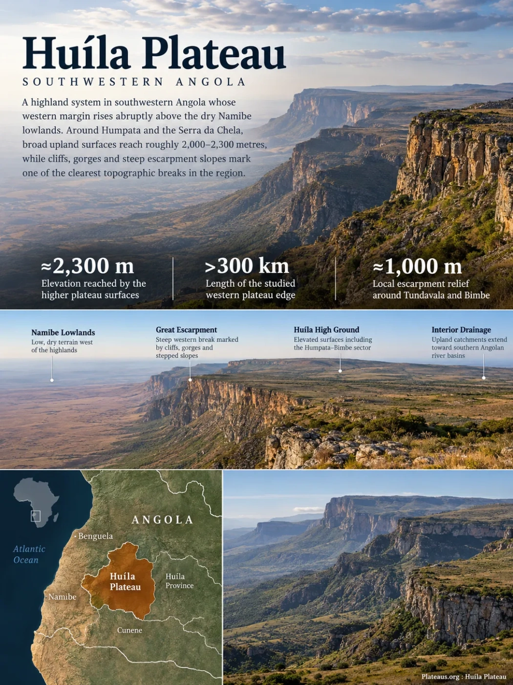
Southwestern Angola · Great Escarpment
The Huíla Plateau is a highland system in southwestern Angola whose western margin rises abruptly above the dry Namibe lowlands. Around Humpata and the Serra da Chela, broad upland surfaces reach roughly 2,000–2,300 metres, while cliffs, gorges and steep escarpment slopes mark one of the clearest topographic breaks in the region.
Elevation reached by the higher plateau surfaces
Length of the studied western plateau edge
Local escarpment relief around Tundavala and Bimbe
A Plateau Defined by Its Western Edge
The Huíla Plateau is best understood as a physical highland rather than as the elevated part of Huíla Province alone. Geological and geomorphological studies trace its western edge for more than 300 kilometres, from the Chongoroi area in Benguela Province southward to the Oncocua area in Cunene Province. Through the central sector, the escarpment forms a natural topographic boundary between the high country of Huíla and the lower terrain of Namibe.
Huíla Plateau and Huíla Province Are Not the Same Boundary
Huíla Province is an administrative unit. The plateau is a landform defined by elevation, relief, rock structure and erosion. The two overlap strongly around Lubango and Humpata, but the physical plateau edge continues beyond the province.
The western margin is not a straight wall. It is cut by canyons, river gorges, fractures and projecting spurs. Researchers commonly divide this margin into a northern Chongoroi sector, a central Humpata sector and a southern Oncocua sector. The central sector is the best-known part because it includes Tundavala, Serra da Leba, Humpata and the high ground west of Lubango.
Low, dry terrain west of the highlands
Steep western break marked by cliffs, gorges and stepped slopes
Elevated surfaces including the Humpata–Bimbe sector
Upland catchments extend toward southern Angolan river basins
Humpata and Bimbe Form the High Central Sector
The names used around the plateau can be confusing because several labels refer to overlapping landforms at different scales. Humpata Plateau usually refers to the central and elevated part of the wider Huíla system west and southwest of Lubango. Within descriptions of this highland, Humpata and Bimbe are also treated as stepped plateau surfaces, with the Humpata surface around 2,000 metres and the higher Bimbe surface around 2,300 metres.
This stepped arrangement matters. The plateau is not one perfectly level table. Broad, relatively flat uplands are separated by scarps, valleys and higher surfaces, and the whole system is tilted and dissected rather than uniformly horizontal. In the northern part of the Humpata highland, some terrain rises above 2,300 metres.
| Name | What It Refers To | Relationship to the Plateau |
|---|---|---|
| Huíla Plateau | The broad regional highland and its western plateau margin | The largest landform name in this group |
| Humpata Plateau | The central high sector west and southwest of Lubango | A major part of the wider Huíla Plateau |
| Bimbe | A higher plateau surface and escarpment locality north of Humpata | Part of the Humpata–Huíla highland system |
| Serra da Chela | The high escarpment belt along the western side of the plateau | Marks one of the sharpest transitions toward the Namibe lowlands |
| Serra da Leba | A steep escarpment sector crossed by the EN280 road | Exposes the western edge of the Humpata sector |
| Tundavala | A deeply incised gap and cliff zone northwest of Lubango | Reveals the scale of the plateau-to-lowland drop |
The Great Escarpment Creates the Plateau’s Sharpest Relief
The most distinctive part of the Huíla Plateau is not its broad upper surface but the place where that surface ends. Along the Serra da Chela, the high ground drops toward the Namibe peneplain through cliffs and steep slopes. This boundary belongs to the wider Great Escarpment of southern Africa, the long continental-scale break in relief that separates many interior uplands from lower coastal terrain.
At Tundavala and Bimbe, local relief across the escarpment can approach 1,000 metres. The edge is deeply cut rather than smooth. Fracture systems in the bedrock guide parts of the drainage and help produce the angular canyons and chasms visible along the western margin.
Tundavala Is an Incised Plateau Edge, Not a Separate Mountain
Tundavala is often described through its cliff views, but its geographic value is clearer when treated as part of the plateau margin. A deep opening has been cut into the western edge, exposing resistant rock layers and creating a direct view from the high surface toward much lower terrain. The landform therefore shows both river incision and escarpment retreat operating on an elevated block.
Serra da Leba Exposes a Natural Cross-Section
South of Tundavala, the EN280 road descends the Serra da Leba in a series of tight bends. Its winding section covers nearly 20 kilometres even though the straight-line distance is less than 7 kilometres, while the route negotiates roughly 1,000 metres of elevation difference. The road cuts through several rock units and structural features, making the descent unusually useful for reading the plateau from top to base.
Along the route, exposed beds rotate from gently inclined positions to near-vertical attitudes in places. Fractures, folds, faults, granitoid basement rocks and younger intrusive rocks can all be observed within a relatively short distance. Eight geosites have been formally described along this road for their geological and educational value.
The Plateau Edge Is Geologically Active as a Slope
Steep slopes and heavily fractured rock make rockfalls, planar slides, wedge failures and debris movement possible, especially during the rainy season. These are slope processes acting on old rocks, not evidence that the plateau itself is geologically young.
Ancient Proterozoic Rocks Underlie a Much Younger Landform
The rocks exposed along the Huíla escarpment are far older than the present shape of the plateau. The basement includes Paleoproterozoic granitoids more than two billion years old. Above them lies the Chela Group, a thick succession of siliciclastic and volcanic-sedimentary rocks deposited roughly 1.9–1.8 billion years ago.
In the central western sector, the Chela Group is commonly described from bottom to top as the Tundavala, Humpata, Bruco and Cangalongue formations. A younger carbonate unit, the Leba Formation, overlies the older succession and contains cherty dolostones with stromatolites.
Dolostone, chert and stromatolitic carbonate rocks
Upper siliciclastic part of the Chela succession
Resistant sedimentary rocks exposed around the escarpment
Sandstone, siltstone and volcanic intervals
Lower part of the exposed Chela Group succession
Ancient granitoid rocks beneath the plateau sequence
The existence of billion-year-old rocks does not mean the present plateau surface is equally old. The modern relief developed much later through regional uplift, erosion and long-term retreat of the continental margin. Studies of the Humpata sector place much of this landscape development in the late Mesozoic and Cenozoic, when uplift and differential erosion began shaping the old rock succession into stepped uplands, cliffs and residual hills.
This distinction also explains why the Huíla Plateau should not be described simply as a volcanic plateau. Volcanic rocks occur within parts of the ancient stratigraphy, but the present landform is mainly an uplifted and erosion-shaped highland, not a broad surface constructed by young lava flows.
Dolostone Turns Part of Humpata Into Karst
Where carbonate rocks of the Leba Formation occur near the surface, water can dissolve the dolostone along fractures and bedding planes. This has produced a local karst landscape with caves, fissures, springs and solution features. The karst is concentrated in suitable carbonate bedrock; it does not cover the entire Huíla Plateau.
The Humpata caves also preserve material that ordinary surface erosion would often remove. Fossil-bearing breccias have accumulated in fissures and cavities, while surveys have recorded caves, rock shelters and open-air sites containing stone artifacts, faunal remains, pottery and burials. The same geology that controls groundwater movement therefore also created natural sediment traps.
Water enters joints and bedding planes.
Carbonate rock slowly dissolves and openings widen.
Subsurface voids and surface karst features develop.
Breccia, fossils and archaeological material can accumulate in protected cavities.
The Escarpment Separates Two Very Different Environments
Elevation changes environmental conditions over a short horizontal distance. West of the escarpment, the Namibe lowlands are hot and arid under the influence of the coastal desert system. On the high plateau, temperatures are lower and moisture availability is generally greater. The change is visible in satellite imagery as well as on the ground.
Rainfall is strongly seasonal. The warmer part of the year carries most of the rain, while the cooler months are much drier. Local conditions vary with elevation and exposure, so a single rainfall or temperature value cannot represent the entire Huíla Plateau. The escarpment can also enhance local cloud and moisture effects where air is forced upward against the high ground.
West of the Escarpment
- Lower elevation
- Arid to very dry conditions
- Open desert and dryland vegetation
- Broad Namibe plains and residual hills
On the High Plateau
- Much higher elevation
- Cooler conditions
- More seasonal moisture
- Grassland, woodland and locally wetter habitats
The Humpata–Bimbe Highlands Are a Center of Endemism
The steep environmental gradient between the coastal lowlands and the high plateau is also a biological boundary. Botanical studies identify the western Angolan highlands as a distinct floristic region, and the Huíla Plateau repeatedly stands out for plants with restricted ranges.
The highest western margin around the Lubango escarpment, Serra da Chela, Tundavala and Bimbe is especially important. Montane grasslands, rocky outcrops, wooded grassland, sheltered valleys and other habitats occur across a relatively narrow elevation belt. Isolation on the high ground has allowed some plant populations to persist with very small geographic ranges.
The exact number of local endemic species should be treated cautiously. Botanical exploration is still incomplete, and plants once thought to occur only on the Huíla highlands may later be found on other Angolan mountains. Recent fieldwork continues to add species records and taxonomic discoveries, so the biological picture remains less complete than the topography might suggest.
Water Moves in Two Very Different Ways Across the Plateau
Surface water near the escarpment can descend rapidly through short, steep valleys. The Sondjo River, for example, cuts a gorge through Chela Group rocks near Serra da Leba and drops toward the Namibe peneplain through a series of falls. These west-facing channels help deepen the escarpment and carry eroded material toward lower terrain.
Other water remains on the highland side and enters inland drainage systems. The southwestern part of the Humpata Plateau lies within the Cunene River basin. At the same time, fractured sandstone, dolostone and other permeable units store and transmit groundwater. Springs and subsurface flow are therefore important parts of the plateau’s hydrology, especially around Humpata and the high ground supplying the Lubango area.
The contrast between fast escarpment runoff and slower groundwater movement is another reason the plateau cannot be understood only from its surface shape. Rock type, fractures, karst openings and the position of drainage divides all influence where water travels after it falls on the high ground.
Recent Satellite Imagery Makes the Plateau Boundary Easy to See
A Landsat 8 and Landsat 9 mosaic acquired on June 19–20, 2025 and published by NASA Earth Observatory in January 2026 shows the western Huíla Plateau as a serrated highland edge above the coastal plains. The escarpment is visible as a sharp, irregular boundary rather than a smooth line, with canyons and projecting ridges breaking the margin.
The same view also shows why elevation matters here. The lower Namibe terrain appears much drier, while the higher plateau supports more vegetation and cooler conditions. Seasonal imagery changes the color of the surface as vegetation dries, but the structural contrast remains: low coastal terrain to the west, a steep escarpment in the middle, and elevated Huíla surfaces inland.