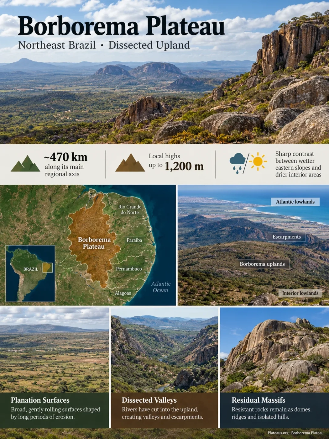
Northeast Brazil • Dissected Crystalline Upland
The Borborema Plateau is a broad, broken-up highland belt behind Brazil’s northeastern Atlantic margin. It extends through parts of Rio Grande do Norte, Paraíba, Pernambuco and Alagoas, where old crystalline rocks form elevated surfaces, escarpments, valleys and residual massifs. Its relief also helps create one of the sharpest environmental transitions in eastern Northeast Brazil: wetter Atlantic-facing slopes give way to drier interior landscapes over a relatively short distance.
Local high points approach 1,200 m
Windward and leeward climate contrast
A Long Upland Belt Behind the Atlantic Margin
The plateau runs broadly northeast–southwest across the eastern part of Northeast Brazil. It is not separated from neighboring terrain by one continuous cliff. Instead, its margins pass through escarpments, piedmonts, lower erosion surfaces and adjoining depressions, so mapped limits vary with the scale and purpose of the relief classification.
In regional terms, the plateau stands between the Atlantic-facing lowlands and the lower interior terrain commonly grouped within the Sertaneja Depression. In Pernambuco and Paraíba, this arrangement is especially clear: coastal plains and tablelands lie to the east, the Borborema rises inland, and lower semi-arid surfaces extend beyond its western side.
Coastal plains and lower tablelands near the ocean.
Escarpments and stepped terrain rising toward the upland.
Dissected surfaces, ridges, valleys and local massifs.
Lower, generally drier terrain toward the Sertaneja Depression.
Boundary Note
The Borborema Plateau is a geomorphic region rather than a single level platform with a survey-style perimeter. Detailed Brazilian relief maps may separate the plateau core, eastern steps, piedmont surfaces, massifs and surrounding depressions into different mapped units.
The Borborema Is Not a Flat Tableland
The Portuguese term planalto describes an upland shaped mainly by erosion and dissection; it does not require a flat top. Borborema fits that idea well. Some sectors preserve broad or gently rolling surfaces, while others are cut by valleys or broken into ridges and steep-sided blocks.
Planation Surfaces
Parts of the upland contain broad, subdued surfaces shaped by long periods of weathering and erosion. The Cariris Velhos area is one example where relatively smooth surfaces occur beside more resistant relief.
Dissected Valleys and Escarpments
Rivers have cut into the upland and its margins, producing stronger local relief. Eastern and western escarpment sectors can form marked breaks between different elevation levels.
Residual Rocky Massifs
Granite and gneiss respond unevenly to weathering and erosion. Resistant bodies can remain as domes, ridges, boulder fields and isolated rocky hills above lower surrounding surfaces.
This mixture explains why one view of the Borborema may show rolling agricultural upland while another shows exposed granite domes or a deeply incised valley. They are different expressions of the same regional highland system, not evidence that the plateau has one uniform surface form.
Elevation Depends on What Part of the Plateau Is Measured
Published elevation ranges differ because authors do not always draw the plateau boundary in the same place. Broad descriptions that include lower margins can extend down to only a few hundred metres above sea level, while large upland sectors commonly stand around 500–1,000 m. Local massifs rise higher, with elevations close to 1,200 m.
Pico do Jabre in Paraíba reaches 1,197 m and is the highest mountain in that state. It is a useful example of the plateau region’s high relief, but its summit elevation should not be presented as the elevation of the plateau as a whole.
Elevation Note
A summit height, a typical plateau-surface elevation and the full elevation range of a mapped region are different measurements. This is why apparently conflicting figures can all describe Borborema correctly when they refer to different terrain units.
The Eastern Escarpment Helps Reorganize Rainfall
Relief changes the movement of humid Atlantic air across the plateau. Air arriving from the east is forced upward along windward slopes. As it rises and cools, rainfall can increase. Farther inland, descending air and greater distance from the ocean favor drier conditions, although local elevation, slope exposure and weather systems keep the pattern from being uniform.
Humid maritime air reaches the coastal side of Northeast Brazil.
The eastern slopes force part of that airflow upward, favoring orographic rainfall.
Some elevated eastern sectors support deeper soils, denser vegetation and humid forest enclaves.
Leeward and interior sectors are more strongly associated with semi-arid climates and Caatinga vegetation.
The contrast can be strong even within one state. Research in the Paraíba sector has used values near 1,200 mm of annual rainfall for wetter eastern windward areas and about 500 mm for drier western sectors. Those figures describe a regional example rather than fixed rainfall values for the entire plateau.
Climate Note
Borborema does not create Northeast Brazil’s semi-arid climate by itself. Regional atmospheric circulation, latitude, distance from the ocean and seasonal weather systems also control rainfall. The plateau mainly modifies that broader climate through elevation and slope exposure.
Brejos de Altitude Form Humid Enclaves Above Drier Terrain
One of Borborema’s most distinctive environmental features is the Brejos de Altitude: humid or relatively humid upland forest enclaves surrounded by much drier landscapes. Many occur on favorable elevated terrain above about 600 m, especially where relief intercepts moist air.
These enclaves are not simply “high-elevation Caatinga.” Their moisture balance can support montane or seasonal forest communities with strong links to Atlantic Forest vegetation. The difference may appear over short distances because altitude and wind exposure change rainfall, cloudiness, temperature and soil moisture together.
Surrounding Semi-Arid Terrain
- Lower and less reliable rainfall in many interior sectors
- Caatinga and other seasonally dry vegetation dominate
- Streams commonly show strong seasonal flow variation
- Shallow or stony soils are common in many exposed settings
Brejo de Altitude Setting
- Higher local moisture input from elevation and exposure
- Forest patches can persist within a drier regional climate
- Headwaters and springs gain local hydrological importance
- Cooler, more humid microclimates support different plant communities
The enclaves are geographically fragmented. That isolation helps explain why they are important for biodiversity and why changes in land cover can affect both habitat continuity and local water sources.
The Rocks Are Far Older Than the Modern Plateau Relief
Much of Borborema is underlain by ancient crystalline rocks, including granitoids, gneisses and other metamorphic units. Many of these rocks record Precambrian tectonic events and the Brasiliano–Pan-African history that assembled crustal blocks before the opening of the South Atlantic.
The visible plateau should not be assigned the same age as those rocks. The basement may be hundreds of millions to billions of years old, while the present high topography reflects much younger uplift, denudation, river incision and weathering superimposed on that older foundation.
Crystalline Terranes Form and Are Reworked
Granitoid, gneissic and metamorphic rocks develop through older crustal events, including major Neoproterozoic deformation in the wider Borborema geological region.
South America and Africa Separate
Rifting and opening of the South Atlantic reorganize the continental margin and reactivate older structural weaknesses in northeastern Brazil.
Regional Cooling, Uplift and Denudation Reshape the High Ground
Thermochronological studies identify major cooling episodes beginning roughly 100–90 million years ago and another younger episode in the Neogene, consistent with regional exhumation and relief development.
Rivers and Slopes Continue to Rework the Surface
Valley incision, hillslope erosion, weathering and sediment storage continue to modify the plateau margins and internal basins without implying that the plateau itself formed during the Quaternary.
Geologic Interpretation
No single mechanism explains every part of Borborema’s present elevation. Research has examined post-rift uplift, inherited faults and shear zones, lithospheric structure, thermal effects and long-term denudation. The relief is better treated as the outcome of several interacting processes than as the product of one uplift event.
Borborema Plateau and Borborema Province Are Not the Same Thing
The two names overlap geographically, but they describe different kinds of geographic objects. Confusing them can make the plateau seem much larger than the landform shown on geomorphological maps.
Borborema Plateau
- A geomorphic and topographic highland
- Defined by elevated relief, escarpments, surfaces and valleys
- Commonly discussed across Rio Grande do Norte, Paraíba, Pernambuco and Alagoas
- Its mapped edge can vary with relief classification and scale
Borborema Province
- A much broader geological and structural province
- Defined by crustal history, terranes, rock units and major shear zones
- Extends beyond the topographic plateau into a wider part of Northeast Brazil
- Used mainly in geology rather than as a synonym for the plateau landform
This distinction also explains why a geological paper about the Borborema Province may discuss areas that do not sit on the Borborema Plateau, while a geomorphological study can focus on the plateau without describing the full geological province.
The Upland Divides Rivers Flowing Toward Different Basins
Borborema is an important drainage-dispersal area. Elevated ridges and interfluves separate catchments that send water in different directions. Some rivers descend eastward toward the Atlantic; others drain toward interior basins or toward tributaries connected with the São Francisco system.
In the southern and central sectors, high ground contributes to drainage associated with rivers such as the Capibaribe and Paraíba, while the southwestern margins also feed tributaries of the São Francisco basin. The exact watershed pattern changes from one part of the plateau to another because the upland is crossed by structural lineaments, valleys and local massifs rather than by one continuous crest.
Water storage becomes especially important in semi-arid sectors where streamflow is strongly seasonal. Reservoirs therefore form a conspicuous part of the human-modified drainage landscape in Paraíba and Pernambuco, alongside natural headwaters and intermittent channels.
Environmental Zones Can Change Within Short Distances
The plateau crosses a climatic transition rather than one uniform biome. Relief, exposure and distance from the Atlantic combine to produce several recurring landscape settings.
| Setting | Relief Character | Moisture Pattern | Common Vegetation Expression |
|---|---|---|---|
| Eastern escarpment and windward uplands | Steeper slopes, dissected terrain and elevated surfaces | Generally wetter where Atlantic air is lifted over the relief | Forest, transitional vegetation and humid enclaves in favorable sites |
| Agreste and central uplands | Rolling to dissected plateau surfaces with local ridges | Strong local variation between wetter and drier sectors | Agricultural mosaics, seasonal vegetation and Caatinga transitions |
| Brejos de Altitude | Elevated humid enclaves on favorable massifs and slopes | Higher local rainfall and moisture retention | Montane or seasonal forest communities |
| Leeward and western sectors | Dissected uplands descending toward lower interior surfaces | Generally drier and more seasonally water-limited | Caatinga and other dry-adapted vegetation |
These zones do not form perfectly parallel bands. A high, wind-exposed massif can be wetter than nearby lower terrain, while an interior basin at similar elevation may remain much drier. Local geology also changes soil depth and drainage, adding another layer to the vegetation pattern.
Quaternary Sediments Record Recent Changes Without Dating the Plateau Itself
Recent geomorphological work has added detail to the younger history of Borborema’s slopes and piedmonts. Studies of unconsolidated deposits along the eastern piedmont have identified sedimentation extending through the late Quaternary, including prominent depositional phases around 25,000 and 9,000 years ago. The deposits record responses to climate shifts as well as local changes in river base level associated with reactivated structures.
Work in a semi-arid Pernambuco watershed on the Borborema highlands also shows how old shear zones can influence where younger fluvial and hillslope sediments accumulate. Valleys and structural depressions act as sediment traps, preserving evidence of alternating erosion and deposition from the Late Pleistocene into the Holocene.
Age Distinction
A 9,000- or 25,000-year-old sediment layer dates a particular episode of deposition. It does not date the crystalline basement, the uplift of Borborema, or the plateau as a whole.