INTERACTIVE CONTEXT MAP
Where is Mato Grosso Plateau?
The selected plateau and nearby mapped locations are shown. Open the full world atlas to explore every region.
The Mato Grosso Plateau is a broad name for the elevated interior landscapes of central-western Brazil, especially across the state of Mato Grosso. It is not one perfectly flat tableland. The region is a mosaic of plateaus, chapadas, escarpments, sedimentary surfaces and dissected uplands that separate some of South America’s major river systems.
Brazilian Highlands
Major drainage divide
Plateaus and chapadas
What the Name “Mato Grosso Plateau” Refers To
Mato Grosso Plateau, or Planalto Mato-Grossense, is most useful as a broad regional term. It refers to the high ground that occupies much of interior Mato Grosso and forms part of the wider Brazilian Highlands.
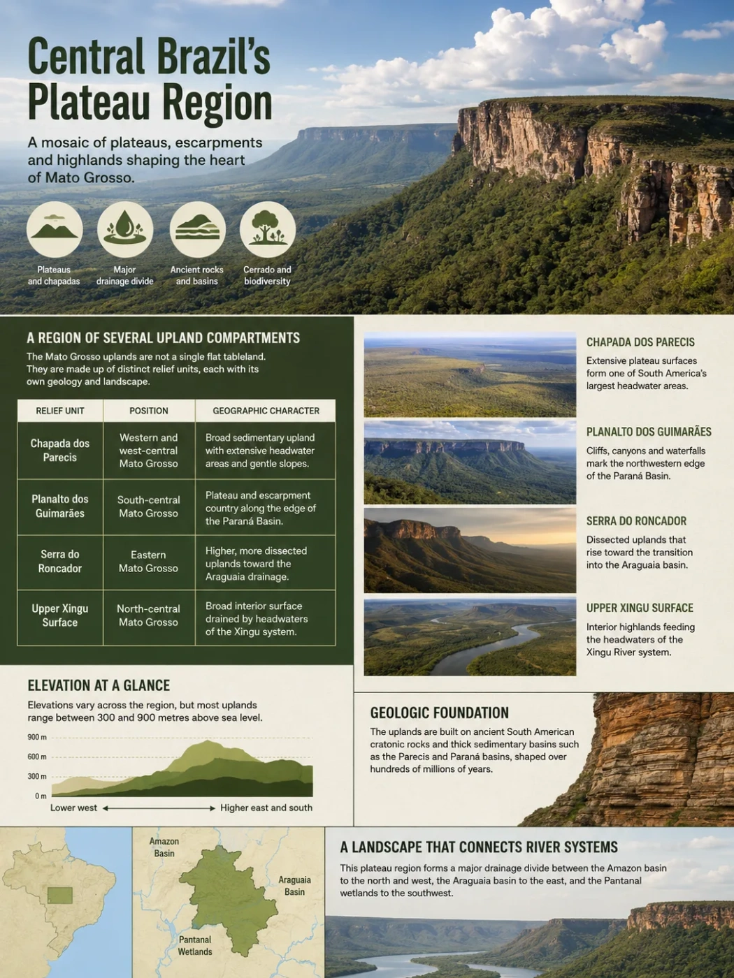
Modern Brazilian relief mapping is more detailed. Rather than treating the whole area as one landform, it separates the uplands into named units such as the Chapada dos Parecis, Planalto dos Guimarães, Serra do Roncador and the Upper Xingu surface, along with nearby depressions and residual plateaus. That makes the Mato Grosso Plateau better understood as a regional upland system than as a single plateau with one exact edge.
Geography Note
The name should not be treated as another name for the entire state of Mato Grosso. The state also includes lower depressions, Amazon-facing surfaces and part of the Pantanal. Likewise, the Pantanal is not part of the plateau surface; it is the much lower floodplain system to the southwest.
A Region of Several Upland Compartments
The plateau changes character from west to east and from the central cerrado belt toward the southern Amazon. The differences reflect both bedrock and long-term erosion.
| Relief Unit | Position | Geographic Character |
|---|---|---|
| Chapada dos Parecis | Western and west-central Mato Grosso, continuing toward Rondônia | Broad sedimentary upland with extensive headwater areas and gently sloping plateau surfaces |
| Planalto dos Guimarães | South-central Mato Grosso, east and northeast of Cuiabá | Plateau and escarpment country developed along the northwestern edge of the Paraná sedimentary basin |
| Serra do Roncador | Eastern Mato Grosso | Higher, more dissected uplands forming part of the transition toward the Araguaia drainage |
| Upper Xingu Surface | North-central Mato Grosso | Broad interior surface drained by headwaters that join the Xingu system |
The Parecis Side
The western plateau country is closely tied to the Parecis Basin, a large intracratonic sedimentary basin extending across Mato Grosso and Rondônia. Its rock record contains sedimentary sequences ranging from the Paleozoic through the Mesozoic and Cenozoic, with igneous intrusions in parts of the basin. The surface landscape is therefore not simply exposed ancient crystalline rock.
Long erosion has cut valleys into these sedimentary uplands while leaving broad interfluves between river systems. The result is the familiar chapada form in many places: a relatively broad top bordered locally by steeper slopes or scarps.
The Guimarães Side
Near Chapada dos Guimarães, the plateau reaches the northwestern margin of the Paraná Basin. Here erosion acts on layered sedimentary rocks, including sandstones and finer-grained units. Cliffs, canyons, waterfalls and isolated remnants make this part of the Mato Grosso uplands look much more abrupt than the broad surfaces farther inland.
The highest parts of the Chapada dos Guimarães area locally reach roughly 700 to 900 metres. Those values describe that upland sector, not the whole Mato Grosso Plateau.
Elevation Is Variable, Not a Single Plateau Level
Broad descriptions often place the Mato Grosso Plateau at roughly 600 metres above sea level, but that figure is best treated as regional shorthand. Once the area is divided into its modern relief units, elevation varies widely between plateau tops, incised valleys, escarpments and adjoining depressions.
The strongest topographic contrast appears toward the southwest. In Upper Paraguay basin studies, the surrounding plateau is commonly separated from the Pantanal lowlands by a broad elevation break: upland sectors lie above the floodplain, while large parts of the Pantanal occupy terrain below about 200 metres.
Elevation Note
There is no single official elevation that defines every place called part of the Mato Grosso Plateau. A local height from Chapada dos Guimarães, the Parecis uplands or an eastern ridge should not be presented as the elevation of the entire region.
The Plateau Is One of Brazil’s Major Watershed Areas
The most important geographic role of the Mato Grosso uplands is their position between major drainage systems. The state of Mato Grosso spans the Amazon, Paraguay and Tocantins-Araguaia hydrographic regions, and much of the separation between them follows elevated terrain.
Headwaters join rivers such as the Juruena, Teles Pires and Xingu, all connected to the Amazon system.
Broad plateau surfaces and ridges separate river networks that ultimately flow in different continental directions.
Water drains toward the Paraguay-Pantanal system or eastward into the Araguaia-Tocantins network.
The divide is not one continuous mountain ridge. In many places it crosses subdued plateau country where a modest change in slope determines whether rainfall eventually travels north into the Amazon system, south toward the Pantanal and Paraguay River, or east toward the Araguaia.
The Paraguay River itself rises in the Chapada dos Parecis. From its headwaters it flows southward and enters the Pantanal near Cáceres. Other plateau-fed tributaries descend from higher ground toward the same low basin, while rivers on the opposite side of the divides flow away from the Pantanal.
Why the Pantanal Begins Below the Plateau
The relationship between the Mato Grosso uplands and the Pantanal is one of the clearest ways to read the regional relief. The plateau supplies steeper headwater channels. The Pantanal provides a much flatter receiving basin where river gradients fall and water spreads across broad floodplains.
This change in slope affects both water and sediment. Rivers leaving upland catchments lose energy as they enter lower terrain, and part of their sediment load is deposited across the basin. Seasonal flooding then redistributes water through channels, floodplains and shallow depressions.
The plateau edge is therefore more than a visual boundary. It marks a change from erosional uplands, where valleys cut into older surfaces, to a depositional lowland shaped by river sediment and repeated flooding.
Cerrado Uplands and the Northern Forest Transition
The Mato Grosso Plateau is a landform region, not a biome. Much of its central and southern upland area is associated with Cerrado vegetation, including open savanna, wooded savanna and gallery forest along rivers. Farther north, the landscape grades toward the southern Amazon forest domain.
This transition does not follow every contour line or plateau edge. Relief, soils, rainfall and drainage interact, so vegetation boundaries can cross geomorphic units. The broad, well-drained surfaces of the plateau also support extensive farming and grazing, especially where slopes are gentle enough for mechanized land use.
In the Chapada dos Guimarães sector, elevation and dissected relief create another local contrast. Plateau tops, sandstone scarps, valleys and spring zones occur within a relatively short distance, producing a much more broken landscape than the flatter interfluves of central Mato Grosso.
How to Recognize the Mato Grosso Plateau on a Relief Map
On a small-scale map of South America, the Mato Grosso Plateau appears as part of the broad interior highlands of Brazil, between the Amazon lowlands to the north and the Paraguay-Pantanal lowlands to the southwest. On a detailed Brazilian geomorphology map, however, the single label largely gives way to several named relief units.
The most reliable way to identify the region is to look for the upland belt that contains the Parecis and Guimarães plateaus and separates major headwater networks. The sharper Pantanal-facing escarpments, the broad sedimentary chapadas and the divides between north-flowing and south-flowing rivers reveal the structure more clearly than any one elevation contour.
This scale difference explains why textbooks may show one “Mato Grosso Plateau” while Brazilian relief maps display several plateaus, chapadas, serras, surfaces and depressions in the same area. Both approaches describe the same central Brazilian upland setting, but at different levels of geographic detail.