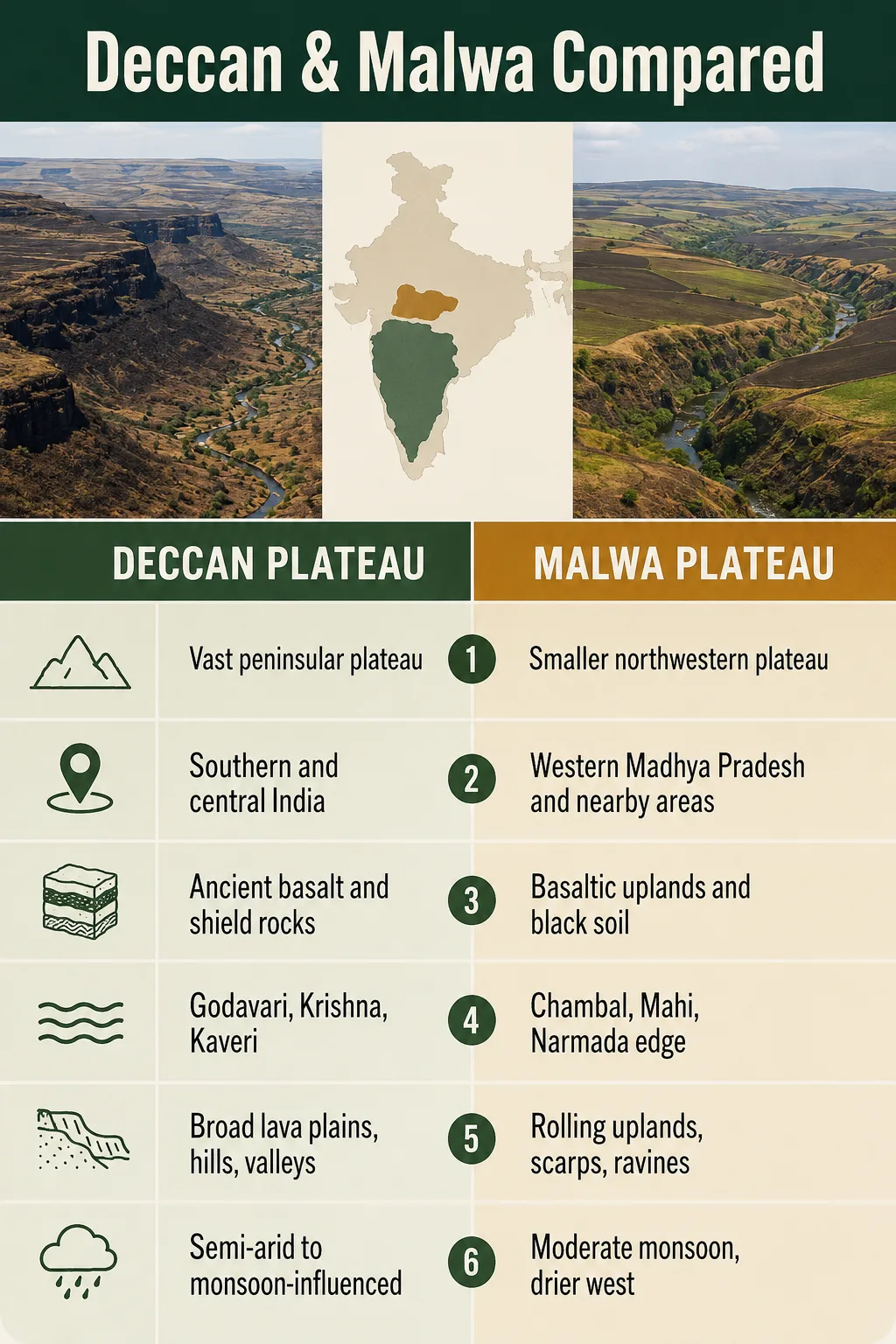
INTERACTIVE CONTEXT MAP
Deccan Plateau and Malwa Plateau on the map
The two plateau systems are shown together for geographic comparison.
Indian Plateau Comparison
The Deccan Plateau and the Malwa Plateau are often linked because both are tied to basaltic lava country, black soils, and the older hard-rock core of India. They are not the same landform. The Deccan is a broad southern plateau system, while Malwa is a smaller central Indian tableland on the northern side of the peninsular plateau belt.
The clearest difference is scale. The Deccan Plateau forms a large triangular upland between the Western Ghats, Eastern Ghats, and the Satpura-Vindhya belt. The Malwa Plateau sits farther north, mainly in western Madhya Pradesh and adjoining Rajasthan, where it acts as a central Indian tableland rather than the main body of the Deccan.
| Feature | Deccan Plateau | Malwa Plateau |
|---|---|---|
| Geographic Position | Southern and south-central India, covering much of the peninsular interior | Central India, mainly western Madhya Pradesh with parts of southeastern Rajasthan |
| Physiographic Role | Main southern plateau of peninsular India | Northern basaltic tableland often grouped with the Central Highlands |
| Approximate Scale | Often mapped at about 422,000 sq km, though boundaries vary | Not consistently reported; smaller regional plateau with variable mapped limits |
| Typical Elevation | About 500-1,000 m, with higher margins near the Ghats and southern uplands | Often about 450-700 m; many areas sit near 500 m |
| General Slope | Mostly west to east | Mostly south or southwest toward north and northeast |
| Main Drainage | Godavari, Krishna, Kaveri, Pennar, Tungabhadra and related peninsular basins | Chambal, Kali Sindh, Parbati, Betwa, Shipra, Mahi and nearby basin systems |
| Geological Link | Large lava and old crystalline-rock plateau; northwest part includes the Deccan Traps | Northern extension of Deccan Trap basalt over parts of the Vindhyan basement |
| Landscape Pattern | Broad upland, lava surfaces, residual hills, valleys, Ghats, semi-arid interiors | Rolling tableland, flat-topped hills, black-soil plains, river valleys and ravines |
Map Note
Google Maps is useful for general orientation, but it does not draw the scientific boundary of either plateau. The Deccan Plateau has broad and changing mapped limits, while Malwa may be defined by physical geography, geology, culture, or administrative regions.
Short Answer: Which Plateau Is Larger and More Distinct?
The Deccan Plateau is far larger and forms one of India’s main physiographic divisions. It covers a broad part of the peninsula and includes several sub-plateaus, such as the Maharashtra Plateau, Karnataka Plateau, Telangana Plateau, and Rayalaseema uplands.
The Malwa Plateau is more local. It is a regional tableland in central India, strongly shaped by basalt, black soil, and north-flowing drainage. It is not simply a small piece of the Deccan in everyday geography, because many descriptions place it within the Central Highlands, north of the main Deccan body.
Simple rule: use Deccan for the broad southern plateau system between the Ghats and central Indian ranges. Use Malwa for the smaller basaltic plateau around western Madhya Pradesh and nearby Rajasthan.
Why the Two Plateaus Are Often Confused
The confusion comes from geology. Both areas are connected to the Deccan Trap volcanic province, a huge basaltic lava region formed by repeated lava flows near the end of the Cretaceous Period. In many parts, weathered basalt has produced black cotton soil, also called regur soil.
That shared rock story does not make the landforms identical. A geological province and a physiographic plateau are not always the same thing. The Deccan Traps spread across parts of western and central India, while the Deccan Plateau as a landform is usually mapped as the large southern upland.
Common Mix-Up
Malwa is basaltic like parts of the Deccan, but it is usually discussed as a central Indian plateau. Its rivers, slope, and position link it more closely with the Central Highlands than with the east-draining interior of the southern Deccan.
Location and Boundaries
The Deccan Plateau occupies much of peninsular India. The Western Ghats form its steep western edge, the Eastern Ghats mark much of its eastern side, and the Satpura-Vindhya region forms a northern transition zone. It reaches across large parts of Maharashtra, Karnataka, Telangana, Andhra Pradesh, and nearby uplands.
The Malwa Plateau lies farther north and west. It covers much of western Madhya Pradesh and extends into southeastern Rajasthan. Indore, Ujjain, Ratlam, Dhar, Dewas, Mandsaur, Neemuch, and nearby districts are commonly linked with the Malwa region. To the south, the Vindhyan scarps and the Narmada valley help separate Malwa from the deeper peninsular interior.
Boundary Difference in Plain Terms
- Deccan Plateau: a broad southern upland framed by the Ghats and central Indian ranges.
- Malwa Plateau: a smaller northern tableland near the Vindhyan edge, above parts of the Chambal and Mahi drainage systems.
- Overlap: geological overlap exists through basaltic lava cover, especially in the northwestern Deccan Trap region.
- Main divide: physiographic maps often place Malwa with the Central Highlands rather than inside the main Deccan Plateau.
Elevation, Relief and Surface Shape
The Deccan is not a perfectly flat surface. It includes uplands, lava steps, residual hills, valleys, scarps, and plains. Its average elevation is often given near 600 m, but the plateau rises higher near the Western Ghats and southern hill systems. The broad surface generally slopes eastward, which helps explain the direction of many peninsular rivers.
Malwa has a gentler regional scale but a distinct surface character. Much of it sits around 500 m, with many areas between about 450 and 700 m. Some local high points rise above 800 m. The land is often described as rolling tableland, with flat-topped hills, shallow valleys, and darker basalt-derived soils.
Elevation Note
Elevation figures vary because plateau boundaries are not drawn the same way in every source. The Deccan includes high Ghats, interior plains, and southern uplands. Malwa’s limits also shift depending on whether the term refers to a physical plateau, a cultural region, or a geological surface.
Geology: Shared Basalt, Different Landform Role
The Deccan Plateau rests on very old peninsular rocks, with wide areas covered by basaltic lava flows in the northwest and west-central parts. These lava sheets cooled into layered basalt. Over time, erosion cut valleys and left step-like scarps, giving the Deccan Traps their well-known terraced look.
The Malwa Plateau is strongly tied to the northern spread of those basalt flows. In several places, basalt lies above older Vindhyan sandstone and shale. This gives Malwa a mixed identity: it has a volcanic surface in many areas, but it also sits near the Central Highlands and Vindhyan escarpment system.
Lava Sheets Spread
Repeated basaltic lava flows covered large parts of western and central India, forming broad stacked rock layers.
Surfaces Hardened
The flows cooled into basalt. In some areas, these rocks formed wide plateaus; in others, they capped older rocks.
Erosion Cut Valleys
Rivers and seasonal runoff carved valleys, scarps, ravines, and rolling tablelands from the lava-covered surface.
Soils Developed
Weathered basalt helped form dark, clay-rich black soils that hold moisture and support cotton, soybean, wheat, and other crops.
Rivers and Drainage: The Strongest Practical Difference
Drainage is one of the best ways to separate the two plateaus. The Deccan Plateau is mostly an east-draining system. The Godavari, Krishna, Kaveri, Pennar, and many tributaries cross the plateau toward the Bay of Bengal. The west-to-east slope is a basic feature of the Deccan interior.
The Malwa Plateau behaves differently. Its central and eastern parts drain through the Chambal, Kali Sindh, Parbati, Betwa, Shipra, and related rivers toward the Yamuna-Ganga system. Its western margin connects with the Mahi Basin, which flows toward the Gulf of Khambhat. This makes Malwa a meeting zone between north-flowing and west-flowing drainage patterns.
Deccan Drainage
Eastward River Flow
Most large rivers cross the plateau toward the Bay of Bengal, cutting long valleys through the peninsular interior.
Malwa Drainage
Chambal and Mahi Influence
Malwa sends water toward the Yamuna-Ganga system through the Chambal side and toward western India through the Mahi side.
Landscape Result
Different Valley Forms
The Deccan has long east-flowing river corridors. Malwa has shorter plateau rivers, fertile valleys, and ravine-prone northern margins.
Climate and Landscape Character
The Deccan has a wide climate range. Many interior parts are semi-arid because the Western Ghats block much of the southwest monsoon moisture from reaching the plateau interior. Rainfall rises near the Ghats and falls across rain-shadow areas. Dry deciduous woodland, scrub, black-soil plains, and cultivated basins all appear within the broader Deccan landscape.
Malwa has a central Indian monsoon climate with hot summers, a rainy season, and cooler winters. Its elevation gives some areas a milder feel than lower plains, but the plateau still depends heavily on seasonal rainfall. Black soils and rolling terrain support soybean, wheat, pulses, cotton, and other crops, especially where moisture is retained in clay-rich soils.
Land Use and Human Geography
The Deccan Plateau supports several large urban and agricultural regions. Cities such as Pune, Hyderabad, Bengaluru, Nagpur, and parts of the wider Maharashtra-Karnataka-Telangana belt sit within or near the broader Deccan system. Farming varies by rainfall, soil, irrigation, and local elevation.
The Malwa Plateau is more compact but very recognizable in human geography. Indore and Ujjain are closely tied to the plateau. The combination of black soil, moderate elevation, and monsoon farming has made Malwa one of central India’s well-known agricultural regions. Its river valleys and trade routes also help connect Rajasthan, Gujarat, and central Madhya Pradesh.
Deccan Plateau vs Malwa Plateau: Main Differences
Deccan Plateau
- Large southern plateau system of peninsular India.
- Bounded by the Western Ghats and Eastern Ghats in many descriptions.
- Mostly drains east toward the Bay of Bengal.
- Includes several sub-plateaus and river basins.
- Has broad lava surfaces, old crystalline rocks, dry interiors, and high escarpments.
Malwa Plateau
- Smaller central Indian plateau in western Madhya Pradesh and nearby Rajasthan.
- Closely linked with the Vindhyan edge and Central Highlands.
- Drains mainly through Chambal-Betwa systems and partly through the Mahi.
- Known for rolling tableland, black soils, and northward drainage.
- Acts as a transition between peninsular basalt country and northern river plains.
How to Tell Them Apart on a Map
On a physical map, first look for the Western Ghats and Eastern Ghats. The broad upland between them across southern India is the Deccan Plateau. Its shape is large and triangular, and many of its rivers run eastward.
Then look north toward western Madhya Pradesh and southeastern Rajasthan. The Malwa Plateau sits near the Vindhyan margin, above the Chambal and Mahi drainage areas. It is smaller, more northerly, and tied to central Indian river basins rather than the main east-flowing peninsular system.
Landform Note
The phrase Deccan Traps refers to a volcanic rock province, while Deccan Plateau refers to a broader landform region. Malwa can share the basaltic rock story without being treated as the same physiographic unit as the main Deccan Plateau.
Best Use of Each Name
Use Deccan Plateau when the subject is southern peninsular India, the Ghats, the Godavari-Krishna-Kaveri river systems, broad volcanic and crystalline uplands, or the main interior plateau south of the Satpura-Vindhya region.
Use Malwa Plateau when the subject is western Madhya Pradesh, southeastern Rajasthan, the Chambal and Mahi basins, black-soil farming in central India, or the basaltic tableland near the Vindhyan escarpment.
Plateau
An elevated land surface with broad areas of relatively level or gently rolling ground, often cut by rivers or bordered by scarps.
Tableland
A plateau-like surface with a broad, flat or gently undulating top. Malwa is often described this way because of its rolling upland surface.
Escarpment
A steep slope or edge separating higher ground from lower land. The Vindhyan edge helps define parts of central India’s plateau landscape.
Deccan Traps
A large basaltic lava province in western and central India. It explains much of the shared rock and soil character of Deccan and Malwa areas.