INTERACTIVE CONTEXT MAP
Where is Malwa Plateau?
The selected plateau and nearby mapped locations are shown. Open the full world atlas to explore every region.
Central India · Basaltic Upland
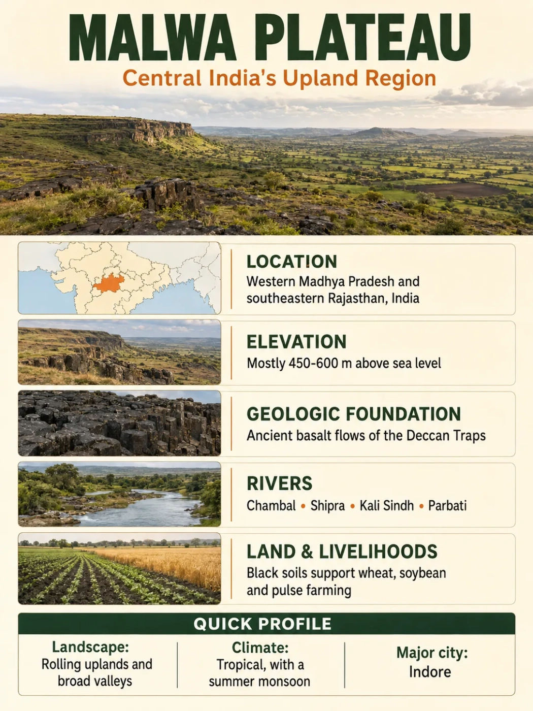
The Malwa Plateau is a rolling volcanic tableland spread mainly across western Madhya Pradesh and adjoining southeastern Rajasthan. Its layered basalt, northward slope, black soils and Chambal-linked drainage give the region a clear physical identity.
The Malwa Plateau forms the northwestern part of India’s Peninsular Plateau. Much of its surface stands near 500 metres above sea level, although low river valleys and local summits create a wider elevation range. It is often described as a volcanic plateau, but erosion has reshaped the original lava surface into broad plains, low ridges, flat-topped hills and shallow valleys.
| Profile Feature | Malwa Plateau |
|---|---|
| Location | West-central India, mainly western Madhya Pradesh with extensions into southeastern Rajasthan |
| Physiographic Position | Northwestern sector of the Peninsular Plateau and northern reach of the Deccan volcanic region |
| Typical Elevation | About 450–600 m, generally higher near the southern and southwestern rim |
| Local High Ground | Some Vindhyan-margin summits exceed 800 m |
| Main Rock | Layered basalt belonging to the Deccan Traps, with older rocks exposed near some margins |
| Plateau Type | Volcanic plateau modified into a rolling and dissected tableland |
| General Slope | Mostly northward or northeastward |
| Main Drainage | Chambal and its tributaries; Mahi drainage in the west and Betwa-linked drainage near the east |
| Common Soils | Deep and shallow black soils, brown soils, stony upland soils and narrow alluvial strips |
| Major Urban Centres | Indore, Ujjain, Dewas, Ratlam, Mandsaur, Neemuch and Shajapur |
Data Note
No single area figure represents every use of the name “Malwa.” Geological, physiographic, historical and cultural maps draw its margins differently. Elevation and extent should therefore be read as regional approximations rather than the dimensions of a surveyed administrative unit.
Map Note
The map provides general orientation. A place label cannot show the plateau’s scientific boundary, which grades into neighbouring uplands rather than following a single administrative line.
A Volcanic Tableland with Flexible Borders
The clearest core of the Malwa Plateau lies around Indore, Ujjain, Dewas, Ratlam and Shajapur. The plateau continues north toward Mandsaur, Neemuch, Agar Malwa and Rajgarh, then merges with uplands associated with the Chambal basin and southeastern Rajasthan.
Its southern side is easier to recognize. Here the high surface meets the Vindhyan escarpment above the lower Narmada valley. The change can be sharp in places, with streams descending through short valleys, gorges and waterfalls. The plateau does not simply end along a straight ridge, however. Basalt-covered uplands, sandstone hills and dissected slopes overlap along the margin.
To the northwest, Malwa approaches the Mewar and Vagad uplands. To the north and northeast, it grades into the Madhya Bharat Plateau and the wider Chambal country. Its eastern limit is less uniform because Malwa meets the Bhopal–Sehore uplands, Vindhyan surfaces and landforms leading toward Bundelkhand.
Physical Malwa and Cultural Malwa Are Not Identical
Malwa can describe a cultural region, a historical territory, a linguistic area or a physical plateau. These meanings overlap but do not have matching borders. A district may belong to cultural Malwa while only part of its terrain lies on the basaltic plateau. Conversely, a geological map may group basalt-covered land with Malwa even where another regional name is more common.
Bhopal illustrates this boundary problem. It is frequently connected with the wider Malwa region, yet many physical maps place it near the plateau’s eastern transition rather than within the western core. Jhabua and Alirajpur are also associated with Malwa in broad regional usage, though their broken hills differ from the smoother central tableland.
How Successive Lava Flows Became Rolling Country
The plateau is the northern continuation of the Deccan Traps, one of Earth’s largest preserved flood-basalt provinces. Most eruptions occurred near the end of the Cretaceous Period and the beginning of the Paleogene, around 66 million years ago.
Lava Spread from Long Fissures
Fluid basalt travelled across wide areas in repeated eruptions. It filled low ground and covered older rocks rather than building one central volcanic cone.
Flows Cooled in Stacked Layers
Each eruption produced another basalt sheet. Successive flows formed the layered volcanic sequence now called the Deccan Traps.
Weathering Lowered the Surface
Heat, water and chemical alteration weakened the upper basalt. Soil formed while softer or more fractured layers wore away faster.
Rivers Cut the Modern Plateau
Chambal-system streams carved valleys into the tilted lava surface, leaving broad divides, low ridges and occasional flat-topped remnants.
The “Trap” Landscape
The word trap comes from a term for steps. It refers to the stair-like slopes that can develop where erosion exposes the edges of separate lava flows. Hard, massive basalt may form a ledge, while weathered or vesicular basalt beneath it forms a gentler slope.
These steps are clearer along dissected hills and escarpments than across cultivated plains. Much of central Malwa looks softly rolling because deep weathering and soil cover have blurred the original volcanic structure.
Older Rocks Beneath the Basalt
The basalt does not have the same thickness everywhere. Older Vindhyan sandstones, shales and limestones occur beneath the volcanic sequence and reappear where erosion has removed the lava cover. Crystalline rocks and sedimentary formations also become more visible near some outer margins.
This mixture explains why Malwa should not be treated as one uniform slab of basalt. Rock type, lava-flow thickness, fractures and depth of weathering change over relatively short distances.
Landform Note
Malwa is often called a lava plateau, but “lava plateau” describes its geological origin. “Dissected plateau” describes much of its present form. Both labels can be correct at the same time.
The Gentle Northward Tilt Controls the Rivers
Much of Malwa falls from approximately 600 metres in the south to around 450–500 metres farther north. This modest tilt determines where most surface water travels. Rivers beginning near the southern high ground commonly turn north or northeast toward the Chambal and ultimately the Yamuna.
The result is unusual when Malwa is viewed as part of peninsular India: rain falling near its southern rim may enter the Ganga drainage system rather than the nearby Narmada.
| River or System | Relationship to the Plateau | Wider Drainage |
|---|---|---|
| Chambal | Rises near the Vindhyan rim southwest of Mhow and drains the central and northern plateau | Flows northeast to the Yamuna and Ganga system |
| Shipra or Kshipra | Crosses the Ujjain area and belongs to the Chambal tributary network | Chambal–Yamuna basin |
| Kali Sindh | Flows north through the eastern and northeastern Malwa country | Joins the Chambal in Rajasthan |
| Parbati and Newaj | Drain rolling uplands toward the north and northeast | Chambal basin |
| Gambhir | Drains part of the Indore–Ujjain sector through the local tributary network | Connected with the Shipra–Chambal system |
| Mahi | Collects water from the western and southwestern side of the wider Malwa region | Flows through Rajasthan and Gujarat to the Arabian Sea |
| Betwa and Eastern Headwaters | Associated mainly with the plateau’s eastern transition rather than its western core | Flow northeast to the Yamuna |
| Narmada | Runs below the southern escarpment and does not cross the main Malwa surface | Flows west through its rift valley to the Arabian Sea |
Why the Chambal Begins on Malwa
The Chambal rises near the Janapav–Singar Chouri high ground on the northern side of the Vindhyan escarpment. Its source is commonly placed at about 843 metres above sea level. From there, it follows the regional northward fall before turning northeast across Madhya Pradesh and Rajasthan.
Several tributaries repeat this pattern. The Shipra, Kali Sindh, Parbati, Newaj and smaller seasonal streams carry monsoon water away from the high southern half of the plateau. Their valleys divide Malwa into broad interfluves rather than steep mountain blocks.
Ravines Belong Mainly to the Northern Drainage Zone
The Chambal is widely associated with ravines, but the deepest badland belts are not spread across the whole Malwa Plateau. They become more extensive farther north and downstream, where running water cuts into softer valley deposits and weathered material.
Within Malwa, river incision appears more often as dissected uplands, narrow valleys, gullied field margins and rocky channels. The famous lower Chambal ravines represent a later and more intense expression of the same northward drainage system.
Common Mix-Up
The Narmada River does not flow across the Malwa Plateau. It occupies a lower east–west rift valley south of the plateau rim. Short streams may descend toward it, but most of Malwa’s central surface drains north toward the Chambal.
Elevation Without Mountain-Scale Altitude
Malwa is elevated relative to the surrounding plains, yet it is not a high plateau in the Himalayan sense. Its broad agricultural surfaces commonly lie between 450 and 600 metres. Indore, for example, stands at about 550 metres, while parts of northern Malwa fall closer to 400–500 metres.
Local summits rise much higher along the southern and southwestern rim. Janapav is commonly reported near 850 metres, while other nearby hills may approach or exceed that height. These summits belong to the rugged Malwa–Vindhyan transition and should not be mistaken for the normal elevation of the cultivated tableland.
Why the Surface Is Not Flat
- River incision has cut shallow and deep valleys into the lava flows.
- Differential weathering removes fractured or softer rock faster than massive basalt.
- Residual hills remain where resistant flow units protect the surface.
- Escarpments form where the plateau drops toward lower terrain, especially near the Narmada valley.
- Soil-filled depressions and river deposits create smoother local plains.
The term plateau therefore describes the region’s elevated foundation and broad surface, not a perfectly level plain.
Why Black Soil Dominates the Farmed Surface
Long weathering of basalt has produced extensive black soils, including deep clay-rich Vertisols and shallower black soils on slopes. These soils expand when wet and shrink during dry weather, often opening wide cracks. Their fine texture allows them to store monsoon moisture well into the dry season.
Black soil is not equally deep across Malwa. Broad, gently sloping areas can hold thick soil profiles, while ridges and strongly dissected land carry shallow, brown or stony soils. Narrow alluvial deposits occur beside rivers, and lateritic or mixed soils appear in some high-rainfall and strongly weathered locations.
From Basalt to a Soybean–Wheat Landscape
The combination of moisture-retaining soil, seasonal rain and relatively open terrain supports intensive farming. Soybean is widely grown during the monsoon season, followed in many areas by wheat or chickpea during the cooler dry season. Maize, pulses, oilseeds and cotton also occur, with crop choice changing according to soil depth, irrigation and local rainfall.
The soil’s water storage is useful, but heavy clay presents practical limits. Saturated fields can become sticky and poorly aerated, while dry soil hardens and cracks. Timely cultivation, field drainage and stored water for dry-season crops remain important parts of farming on the plateau.
Water Below the Basalt
Massive unbroken basalt has little pore space. Groundwater is held mainly in weathered zones, fractures, joints, vesicular flow tops and contacts between lava layers. A productive well may therefore occur near a fractured or weathered band while another well nearby reaches dense rock with less storage.
Most recharge arrives during the southwest monsoon. Tanks, reservoirs, check dams and irrigation systems help retain part of this seasonal water, especially where natural groundwater storage is uneven.
Monsoon Rhythm Across an Elevated Interior
Malwa has a tropical monsoon climate with three clear seasonal phases. Summers are hot, the main rains arrive from June to September, and winters are cooler and mostly dry. Daytime temperatures can exceed 40°C before the monsoon, although elevation often allows greater night-time cooling than in nearby lowlands.
Rainfall is not uniform. Much of the plateau receives roughly 800–1,100 millimetres in an average year, with local totals varying by position and season. Western and northwestern districts are generally drier than parts of the east and southeast. Year-to-year variation matters because a large share of the rain falls within a short monsoon period.
Cooler winter conditions support wheat, chickpea and other dry-season crops. Occasional winter rain can add useful soil moisture, but most annual water supply still comes from the summer monsoon.
Vegetation and Cultivated Land
The natural vegetation belongs mainly to tropical dry deciduous and scrub formations. Teak and mixed deciduous trees survive on hill slopes, forest patches and less accessible ground. Grasses and thorny shrubs occur where soils are shallow or seasonal dryness is stronger.
Large areas of the smoother plateau have been cultivated for generations. Remaining woodland is therefore concentrated more heavily on broken uplands, escarpments, river margins and protected tracts than on the broad black-soil plains.
Cities and Routes on the Upland
The relatively open surface has supported closely spaced farming settlements, market towns and transport routes. Indore is the plateau’s largest urban and commercial centre. Ujjain, Dewas, Ratlam, Mandsaur, Neemuch and Shajapur connect surrounding agricultural districts with processing, trade and transport networks.
The plateau’s position also links northern and western India with the Narmada corridor and the Deccan interior. Roads and railways can follow the rolling upland across much of Malwa, while routes descending the southern escarpment encounter steeper gradients and more broken terrain.
Urban growth is most concentrated around Indore and the Indore–Dewas–Ujjain sector. Elsewhere, settlement remains closely tied to cultivated plains, river crossings, reservoirs and long-used regional routes.
How to Recognize Malwa on a Physical Map
Malwa is easier to identify by combining several map clues than by looking for one boundary line:
- Find western Madhya Pradesh and the adjoining southeastern corner of Rajasthan.
- Locate the Narmada valley running east to west. Malwa lies mainly north of this lower corridor.
- Look for the Chambal and its south-to-north tributaries, especially the Kali Sindh, Parbati and Shipra systems.
- Identify the broad 450–600 metre surface around Indore, Ujjain, Dewas, Ratlam and Shajapur.
- Check the geology: widespread Deccan basalt separates the plateau’s core from neighbouring crystalline and sedimentary uplands.
Field Note
A map showing only state or district borders can make Malwa appear more exact than it is. Relief, drainage and bedrock maps give a better picture of the physical plateau.
Frequently Asked Questions
Where is the Malwa Plateau located?
It lies in west-central India, mainly across western Madhya Pradesh and adjoining southeastern Rajasthan. Indore, Ujjain, Dewas, Ratlam and Shajapur stand within its best-recognized core.
How high is the Malwa Plateau?
Much of the surface lies about 450–600 metres above sea level, with an average often stated near 500 metres. Local hills along the southern rim rise above 800 metres.
How was the Malwa Plateau formed?
Repeated basaltic lava flows spread across the region near the end of the Cretaceous Period. Weathering and river erosion later converted the layered volcanic surface into the modern rolling and dissected plateau.
Which is the main river of the Malwa Plateau?
The Chambal is the main river system. The Shipra, Kali Sindh, Parbati and several smaller rivers carry water north or northeast into the Chambal–Yamuna drainage network.
Does the Narmada flow through the Malwa Plateau?
No. The Narmada flows through a lower rift valley south of the plateau. The Vindhyan and Malwa escarpments overlook this valley in several places.
Why does the Malwa Plateau have black soil?
Clay-rich black soils developed through long weathering of Deccan basalt. They hold moisture well and commonly expand when wet and crack during the dry season.
Is the Malwa Plateau part of the Deccan Plateau?
It is commonly treated as the northern or northwestern volcanic extension of the Deccan Plateau. In broader Indian physiography, it is also grouped with the Central Highlands north of the Narmada.
Is Malwa a completely flat plateau?
No. It contains broad plains, low ridges, flat-topped hills, river valleys, gullies and steep escarpment sections. “Plateau” refers to the region’s elevated base rather than a uniformly level surface.
Is the Malwa region the same as the Malwa Plateau?
Not exactly. The cultural and historical Malwa region overlaps the physical plateau but may include neighbouring hills and transitional areas. Geological and physiographic maps usually define the plateau more narrowly.