INTERACTIVE CONTEXT MAP
Where is Deccan Plateau?
The selected plateau and nearby mapped locations are shown. Open the full world atlas to explore every region.
Landform Profile · Peninsular India
The Deccan Plateau is a broad, east-tilted upland covering much of interior southern India. Ancient crystalline rocks form its foundation, while vast flood-basalt layers shape its northwestern sector. This mixed geology controls the plateau’s soils, rivers, groundwater, farming regions, and distinctive stepped terrain.
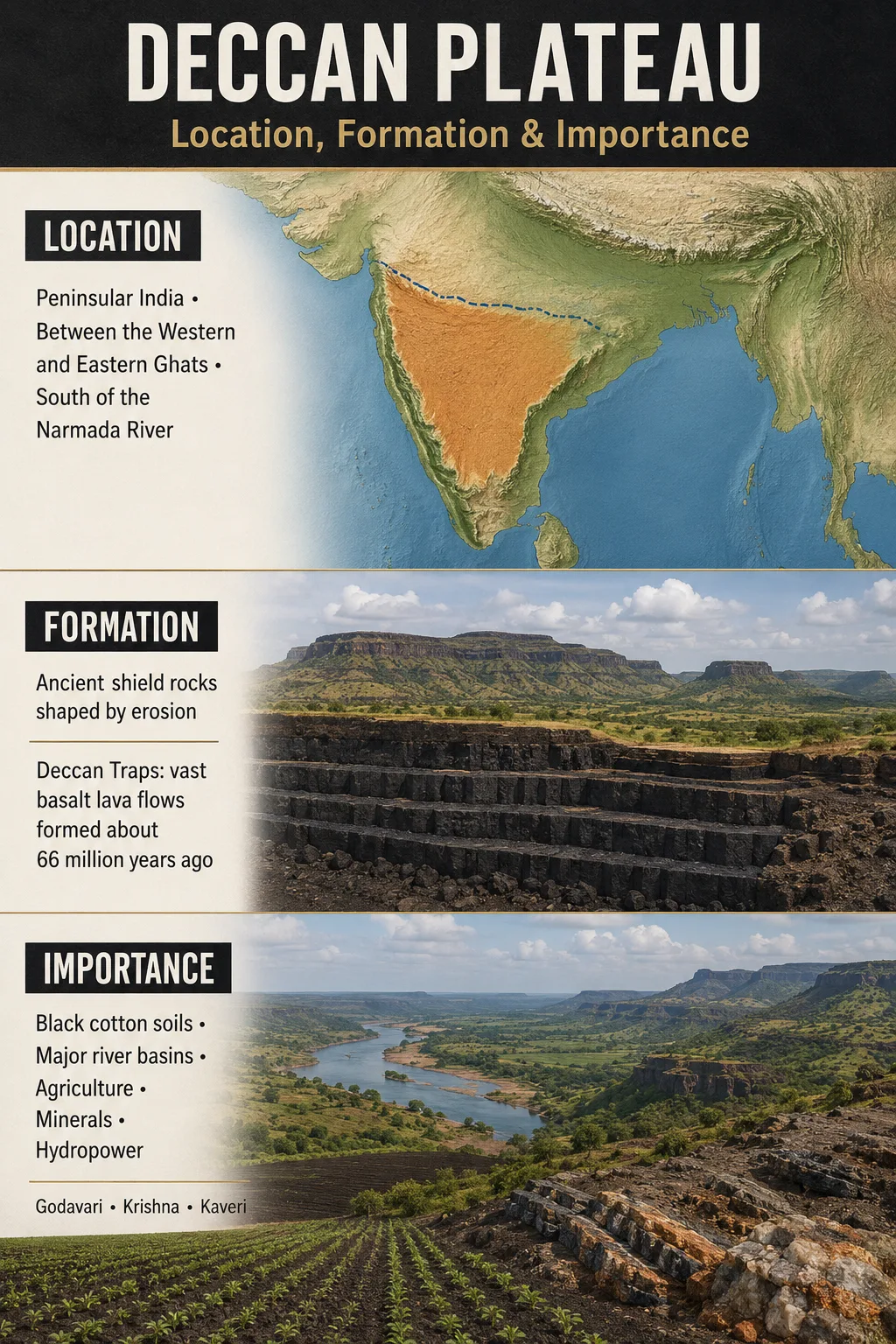
The Deccan Plateau occupies much of the Indian peninsula south of the Narmada valley. Its best-known boundaries are the Western Ghats on the west, the Eastern Ghats on the east, and the Satpura–Vindhya region toward the north. Most of Maharashtra, Karnataka, Telangana, and interior Andhra Pradesh lies within commonly used definitions of the plateau.
| Profile Element | Deccan Plateau Description |
|---|---|
| Name | Deccan Plateau (Deccan comes from a word meaning “south”) |
| Location | Interior western and southern India |
| Core Regions | Much of Maharashtra, Karnataka, Telangana, and inland Andhra Pradesh; some definitions reach northern Tamil Nadu and adjoining uplands |
| Approximate Area | About 422,000 km² (163,000 sq mi) under one widely used definition; the total changes when broader peninsular margins are included |
| Typical Elevation | Commonly about 300–900 m (980–2,950 ft), with a regional mean often placed near 600 m (1,970 ft) |
| Highest Terrain | Western and southern rim zones rise above 1,000 m; nearby Ghats and hill massifs are higher than the main plateau surface |
| Landform Type | Composite plateau with flood-basalt, crystalline, erosional, and dissected upland sectors |
| General Gradient | Higher along the western side and lower toward the east |
| Dominant Rock Domains | Deccan flood basalts in the northwest; older granite, gneiss, schist, and related crystalline rocks across much of the south and east |
| Climate | Tropical monsoon climate with wet western margins, drier rain-shadow interiors, and regional variation toward the southeast |
Measurement Note
The Deccan has no single surveyed administrative boundary. Area and elevation figures vary because some maps treat it as the triangular plateau between the Ghats, while others use “Deccan” for a broader part of peninsular India. The Western Ghats, Nilgiri Hills, and neighboring uplands may be included as margins in one definition and separated in another.
A Tilted Interior Between Two Ghats
The plateau is often drawn as an inverted triangle. Its broad northern side lies near the Narmada–Satpura zone, while the land narrows toward the southern uplands. The Arabian Sea lies beyond the Western Ghats, and the Bay of Bengal lies beyond the Eastern Ghats.
Map Note
The map is useful for orientation, but its place label does not trace a scientific boundary. The plateau crosses state borders and merges gradually with hill belts, river valleys, and other peninsular uplands.
The Western Edge
The Western Ghats, or Sahyadri, form the plateau’s most abrupt margin. From the narrow Konkan and Malabar coastal belts, the land rises sharply toward an elevated interior. In many places the Ghats work as a long escarpment rather than a separate mountain chain sitting on level ground.
This high western rim intercepts moisture-bearing winds from the Arabian Sea. It also creates the starting zone for many rivers that cross the plateau toward the Bay of Bengal.
The Eastern Edge
The Eastern Ghats are lower, older, and less continuous. The Godavari, Krishna, Kaveri, and other rivers pass through gaps in these hills before entering the eastern coastal plains. Long erosion, old rock structures, and river incision explain why the eastern margin appears broken rather than forming an unbroken wall.
The Northern and Southern Limits
The Narmada valley and the Satpura–Vindhya region commonly mark the northern transition. The Narmada itself is usually treated as a boundary river rather than one of the main rivers crossing the Deccan interior.
In the south, the plateau merges with the elevated terrain of Karnataka and the hill systems around the Nilgiris. There is no equally sharp southern line. This is one reason published maps do not always show the same outline.
One Plateau, More Than One Geological Foundation
Calling the whole Deccan a volcanic plateau hides an important distinction. The northwestern Deccan is dominated by immense basalt flows. Much of the southern and eastern plateau, however, exposes far older crystalline rocks that existed long before those eruptions.
| Term | What It Describes | Geographic Meaning |
|---|---|---|
| Deccan Plateau | The broad elevated landform of interior peninsular India | Includes several rock provinces, river basins, soil regions, and terrain types |
| Deccan Traps | A continental flood-basalt province formed by repeated lava eruptions | Dominates northwestern parts of the plateau and extends into adjoining west-central India |
| Peninsular Plateau | A wider physiographic term for India’s ancient southern plateau region | May include the Deccan and central highlands that some classifications treat separately |
Common Mix-Up
The Deccan Plateau and Deccan Traps are not identical. The first is a landform region. The second is a volcanic rock province. Large areas of Karnataka, Telangana, and Andhra Pradesh belong to the plateau but rest mainly on granite, gneiss, and other ancient rocks rather than thick trap basalt.
How the Deccan Plateau Formed
The modern plateau records several episodes of Earth history. Its formation cannot be reduced to one eruption or one period of uplift.
An Ancient Crystalline Base
Granites, gneisses, schists, and related rocks formed and changed deep within the crust over very long periods. These Precambrian rocks now appear across much of Karnataka, Telangana, and southeastern parts of the plateau.
Gondwana Breakup and Margin Development
As the Indian landmass separated from other parts of Gondwana, rifting affected its western margin. Crustal movement, uplift, and later erosion helped create the high western side of peninsular India.
Repeated Flood-Basalt Eruptions
Around 66 million years ago, enormous volumes of fluid basaltic lava erupted through long fissures. Successive flows spread across west-central India and hardened as stacked sheets. The main eruptive phase occurred within a relatively short interval in geological terms.
Weathering, Tilting, and River Incision
Rivers cut valleys through basalt and crystalline rock. Chemical weathering produced black, red, and lateritic soils, while the higher western rim and lower eastern side organized the present drainage pattern.
Why the Basalt Forms Steps
The word trap comes from a term for “stairs.” It describes the stair-like hills produced where erosion cuts through stacked lava flows. A resistant flow may form a bench or cliff, while weaker or more weathered material retreats faster.
Flat-topped hills, mesas, scarps, and terraced valley sides are therefore common in the basalt country of Maharashtra. Individual lava flows can also contain massive, jointed, vesicular, and weathered layers. These differences affect both slope shape and groundwater storage.
The Link to the Réunion Hotspot
Deccan volcanism is widely linked to mantle activity associated with the Réunion hotspot as the Indian Plate moved northward. The exact relationship among the mantle plume, regional rifting, magma pathways, and eruption timing remains an active geological subject. The eruptions occurred near the Cretaceous–Paleogene boundary, but they began before the Chicxulub impact.
2026 Research Update: Deccan Volcanism and the K–Pg Boundary
An August 2026 study identified two separate mercury signals around the K–Pg boundary. The earlier signal was linked to Deccan volcanism, while the later signal was associated with the Chicxulub impact. The separation adds new geochemical evidence to efforts to distinguish volcanic activity from impact effects in sediments deposited around the extinction interval.
The results support interpreting the Chicxulub impact as the primary trigger of the K–Pg mass extinction, while leaving room for Deccan volcanism to have added environmental stress before and around the boundary. The finding refines the timing and source evidence without treating the long-running Deccan–Chicxulub question as fully settled.
Regional Landscapes Within the Plateau
The Deccan is not a single smooth table. Rivers, rock differences, fault zones, residual hills, and uneven weathering divide it into several recognizable terrain regions. The names and limits used for these regions vary among physiographic maps.
| Regional Terrain | Main Rock and Relief | Geographic Character |
|---|---|---|
| Maharashtra Plateau | Layered basalt, mesas, scarps, broad valleys, and residual hill ranges | The clearest expression of Deccan Trap topography; mainly drained by the Godavari, Bhima, and their tributaries |
| Western Karnataka Uplands | High, deeply weathered crystalline terrain near the Western Ghats | Wetter and more dissected than the interior; forms headwaters for east- and west-flowing rivers |
| Karnataka or Mysore Plateau | Granite and gneiss surfaces with rolling plains, rocky hills, and broad drainage divides | Generally higher in the west and south, grading toward drier eastern plains |
| Telangana Plateau | Granite–gneiss terrain, tors, low ridges, shallow valleys, and scattered basaltic areas | Lies mainly within the Godavari and Krishna basins; surface water is strongly seasonal |
| Rayalaseema Uplands | Weathered crystalline rocks, low hills, pediments, and broad erosional surfaces | A drier southeastern interior crossed by parts of the Pennar and Krishna drainage systems |
| Southern Transition | Elevated crystalline surfaces merging with hill blocks and river-cut basins | Links the Karnataka plateau with the Nilgiri and Tamil uplands; its inclusion varies by definition |
The Eastward Tilt Organizes the River Map
The highest continuous rim lies close to the west coast, yet most large rivers travel east. This apparent puzzle is explained by the plateau’s broad gradient: after rising near the Western Ghats, the land generally slopes toward the Bay of Bengal.
The result is an uneven drainage pattern. Major east-flowing rivers have long courses and large catchments. Rivers descending the seaward face of the Western Ghats usually have much shorter, steeper channels.
| River System | Plateau Connection | General Outlet |
|---|---|---|
| Godavari | Rises near the Western Ghats and crosses the northern Deccan; major tributaries include the Pravara, Manjira, and Pranhita system | Bay of Bengal |
| Krishna | Crosses the central and southern plateau; receives the Bhima, Tungabhadra, Ghataprabha, and Malaprabha | Bay of Bengal |
| Kaveri | Drains the southern uplands through Karnataka and Tamil Nadu; tributaries include the Kabini, Hemavati, Shimsha, and Bhavani | Bay of Bengal |
| Pennar | Drains parts of the drier southeastern plateau in Karnataka and Andhra Pradesh | Bay of Bengal |
| Short Western Rivers | Descend rapidly from the Western Ghats through small, steep catchments | Arabian Sea |
| Tapi | Flows west through a structural valley near the northern Deccan margin | Arabian Sea |
Rivers as Landscape Makers
Plateau rivers do more than carry water. They separate upland blocks, cut gorges through resistant rock, expose sequences of basalt flows, and transport sediment toward the coastal plains. Falls and rapids occur where channels cross resistant ledges or descend between erosion surfaces.
Farther east, the largest rivers pass through gaps in the Eastern Ghats. They then lose gradient across the coastal plain and build broad alluvial and deltaic landscapes outside the plateau proper.
Groundwater Below a Hard-Rock Plateau
Groundwater storage is uneven because most Deccan rocks lack the wide, continuous pore spaces found in thick sand or gravel aquifers. Water instead occupies weathered layers, fractures, joints, faults, and vesicular zones.
- In basalt country, productive water-bearing zones may occur near weathered flow tops, fractures, or the contact between lava units.
- In granite and gneiss terrain, groundwater is concentrated in the weathered mantle and fractured bedrock.
- Two nearby wells can produce very different amounts of water when they intersect different fracture systems.
- Recharge is closely tied to monsoon rainfall, soil depth, slope, and the condition of local tanks, lakes, and stream channels.
Hydrology Note
A hard-rock plateau is not automatically impermeable. Deccan basalt and crystalline rocks can store useful groundwater, but the water occurs in discontinuous zones. Aquifer depth and yield therefore change sharply over short distances.
Monsoon Relief Creates Sharp Moisture Contrasts
The Deccan has a tropical monsoon climate, but relief creates strong local contrasts. Moist air from the Arabian Sea rises along the Western Ghats and releases heavy rain on the seaward slopes and crest zone. Air descending into the interior is drier, producing a broad rain-shadow region across parts of Maharashtra, Karnataka, and Telangana.
Most of the interior receives much of its annual rain during the southwest monsoon from June to September. The southeastern plateau can also receive rain from retreating and northeast-monsoon systems later in the year. Rainfall varies from season to season, so drought and intense runoff can occur within the same river basin at different times.
Elevation and Temperature
Higher plateau cities and uplands are often cooler than nearby low coastal plains, especially at night. Bengaluru’s elevated setting is one familiar example. Lower basins and drier northern interiors can become very hot before the summer monsoon arrives.
Elevation alone does not control temperature or moisture. Latitude, cloud cover, exposure to monsoon winds, soil moisture, and distance from the sea also shape local conditions.
Rock, Soil, and Farming Patterns
The plateau’s soil map follows its geological map more closely than a simple “Deccan equals black soil” rule suggests.
Black Soils on Basalt
Many parts of Maharashtra and adjoining basalt regions carry deep to shallow black soils, often called regur. Their clay minerals expand when wet and shrink during dry weather, producing wide cracks. These soils hold moisture well but can become sticky when saturated and hard when dry.
Cotton is strongly associated with black-soil districts. Sorghum, pulses, oilseeds, wheat, sugarcane, and other crops are also grown, depending on rainfall, irrigation, soil depth, and local markets.
Red and Loamy Soils on Crystalline Rock
Red and reddish-brown soils are widespread over granite and gneiss terrain in Karnataka, Telangana, Andhra Pradesh, and adjoining southern uplands. Their color commonly reflects iron oxides. Many are lighter and better drained than deep black soils, but their depth and ability to retain water vary.
Millets, groundnut, pulses, maize, cotton, and irrigated crops occur across these regions. Farming choices depend heavily on water access because much of the interior has a long dry season.
Laterite on Wet Uplands
Heavy rainfall and strong chemical weathering produce lateritic soils and crusts along parts of the Western Ghats and other wet elevated surfaces. Leaching removes mobile minerals and leaves material rich in iron and aluminum compounds. Lateritic plateaus may appear dry and rocky for part of the year, then support shallow pools and short-lived plant communities during the monsoon.
Why the Deccan Plateau Matters
A Major Watershed
The plateau organizes drainage across southern India. The Godavari, Krishna, Kaveri, Pennar, and their tributaries connect high western catchments with interior farming districts, reservoirs, cities, and eastern coastal plains.
Reservoirs and traditional water-storage systems help bridge the long dry season. Tanks are especially common across the crystalline plateau, where natural groundwater storage can be limited or difficult to predict.
A Broad Agricultural Interior
Black-soil plains, red-soil uplands, irrigated valleys, and rain-fed drylands support different crop systems. This variety makes the plateau one of India’s main agricultural regions, although rainfall reliability and access to stored water differ greatly between districts.
The plateau’s physical geography also affects field size, mechanization, erosion, and road access. Broad plains allow extensive cultivation, while dissected scarps, shallow rocky soils, and residual hills restrict it.
A Base for Large Inland Cities
Bengaluru, Hyderabad, and Pune occupy elevated parts of the wider Deccan region. Their locations offered relatively moderate upland climates and access to regional transport routes, but they also face the water limits of seasonal hard-rock landscapes.
Urban growth has connected distant reservoirs, river transfers, groundwater fields, lakes, and local catchments. The plateau’s slope and drainage divides influence where water can be stored, pumped, or moved between basins.
Geological Resources and Building Stone
The plateau crosses several geological provinces, so its resources are unevenly distributed. Basalt is widely used as aggregate and construction stone in the northwest. Ancient crystalline belts contain metal ores, industrial minerals, and locally valuable stone. Weathering of upland surfaces has also produced laterite and bauxite in suitable settings.
These materials belong to particular rock belts rather than to every part of the plateau. A general claim that the entire Deccan has the same mineral wealth would ignore its varied geology.
Habitats Shaped by Rainfall and Rock
Vegetation changes from moist forests along the western rim to dry deciduous woodland, scrub, grassland, and cultivated terrain across the interior. River corridors, granite hills, basalt cliffs, and seasonal lateritic plateaus add smaller habitat zones within this broad pattern.
The Western Ghats form the wet ecological edge of the region, while interior plateaus support plants and animals adapted to longer dry periods. Many rocky surfaces that appear bare in the dry season become biologically active after monsoon rain.
How to Read the Deccan on a Physical Map
- Find the triangular upland south of the Narmada and between the Western and Eastern Ghats.
- Look for the steep rise from the narrow western coastal plain to the high western rim.
- Follow the Godavari, Krishna, and Kaveri eastward across the plateau.
- Notice how these rivers cut through the discontinuous Eastern Ghats before reaching the coastal plain.
- Separate the broad plateau surface from individual peaks in the Ghats; the highest mountain is not automatically the plateau’s highest surface.
- Use geological maps to distinguish the northwestern basalt province from the older crystalline terrain of the south and east.