INTERACTIVE CONTEXT MAP
Where is Edwards Plateau?
The selected plateau and nearby mapped locations are shown. Open the full world atlas to explore every region.
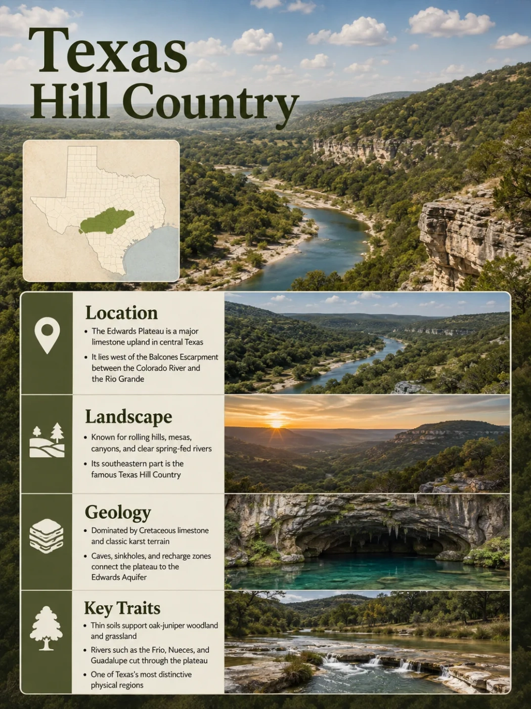
The Edwards Plateau is a broad limestone upland across west-central and south-central Texas, but its best-known landscape appears along the eastern and southern margins, where rivers have cut the old plateau surface into the hills, steep-sided valleys, springs and canyons associated with the Texas Hill Country. The contrast between a comparatively open plateau interior and a deeply dissected margin is the central feature of its geography.
Dissected into the Texas Hill Country
Karst, springs and groundwater
Edwards Plateau and Texas Hill Country Are Related, but Not Identical
The names Edwards Plateau and Texas Hill Country often overlap in everyday use, but they describe the landscape at different scales. The Edwards Plateau is the larger physiographic upland. The Hill Country is most closely associated with the strongly dissected eastern and southern margins of that upland, where erosion has broken the plateau into limestone hills, narrow ridges and incised valleys.
Edwards Plateau
- A broad regional physiographic province in Texas.
- Includes relatively level or rolling plateau surfaces as well as deeply dissected terrain.
- Dominated across large areas by Lower Cretaceous limestone and dolomite.
- Extends well beyond the landscape commonly pictured as the Hill Country.
Texas Hill Country
- Most strongly associated with the dissected eastern and southern plateau margins.
- Characterized by steep valleys, limestone ridges, canyon walls and spring-fed streams.
- Closely tied to the Balcones Escarpment and the erosion of the plateau edge.
- Its popular and cultural boundaries are less precise than a mapped physiographic boundary.
The distinction matters because the western Edwards Plateau does not look like the familiar countryside west of Austin or northwest of San Antonio. Large western areas retain broader, more subdued upland surfaces. Moving toward the east and southeast, stream incision becomes much more apparent and the terrain develops the relief normally associated with Hill Country scenery.
Why Edwards Plateau Maps Differ
A physiographic map, an ecological-region map, an aquifer map and a popular Texas Hill Country map are not mapping the same thing. Their boundaries can therefore differ without one of them necessarily being wrong. A physiographic boundary follows landform and geologic structure; an ecoregion also considers soils, vegetation, climate and hydrology; an aquifer boundary follows water-bearing rock units; and the popular Hill Country has no single universally accepted scientific perimeter.
How a Broad Plateau Becomes Hill Country
The word plateau can create the misleading impression of an uninterrupted flat surface. Edwards Plateau geography is better understood as an elevated regional surface that has survived to very different degrees in different places.
The western and interior portions preserve broad uplands, rolling surfaces and relatively open drainage divides. Along the eastern and southern margins, rivers and tributaries have cut much more deeply into the limestone. Continued valley enlargement separated pieces of the former upland surface and left steep slopes between the remaining high ground and the stream valleys below.
Cretaceous carbonate rocks form an extensive elevated surface across the plateau.
Streams cut downward and headward into the plateau, especially along its eastern and southern margins.
Differential erosion and resistant limestone beds produce cliffs, ledges and steep-walled valleys.
Remnants of the former upland remain as ridges, divides and flat-topped or rolling high ground between valleys.
The resulting landscape looks hilly even though its high ground belongs to a dissected plateau system.
This is why local relief is more useful than elevation alone when interpreting the Hill Country. Two places can occupy comparable regional elevations while looking very different if one lies on a broad plateau top and the other beside a deeply entrenched river valley.
The Balcones Escarpment Defines the Strongest Break in the Landscape
The eastern and southern edge of the principal Edwards Plateau closely follows the Balcones Escarpment, a major topographic break associated with the Balcones Fault Zone. It forms one of the clearest transitions in central Texas: higher, dissected limestone country lies to the west and northwest, while lower terrain extends toward the Gulf Coastal Plains.
The fault zone consists of a curved belt of mainly normal faults. Faulting displaced Cretaceous rocks and helped establish a structural margin between the more stable interior and the subsiding coastal side. Erosion later emphasized that structural difference. Softer material was removed, streams cut back into the uplifted margin, and resistant limestone beds remained as the ledges, bluffs and canyon walls now common in the Hill Country.
Broader uplands and drainage divides retain more of the regional plateau surface.
Rivers, tributaries and erosion divide the limestone surface into hills, valleys and canyons.
Fault-related relief marks the transition toward lower central and south-central Texas landscapes.
Austin and San Antonio lie close to this regional transition. Around Austin, the change can be especially abrupt: comparatively subdued terrain east of the fault-zone margin gives way westward to rugged limestone country with flat-topped hills and steep canyon sides. The physical contrast helps explain why the Hill Country can begin so suddenly rather than gradually merging into the plains.
The escarpment should not be imagined as a single continuous cliff. It is a regional topographic and structural boundary expressed through faulted rock, slopes, stream valleys and changes in elevation across a broad belt.
Cretaceous Limestone Controls the Shape of the Plateau
The Edwards Plateau is fundamentally a carbonate-rock landscape. Much of its surface is formed from Lower Cretaceous limestone and dolomite deposited when shallow marine environments covered this part of Texas roughly 100 million years ago.
Different carbonate units do not weather in exactly the same way. Thick, resistant limestone beds tend to hold up plateau tops, benches, cliffs and ledges. Softer or more marly layers erode more readily. Where resistant and weaker beds alternate, slopes can develop a stair-step profile instead of a smooth hillside.
The Edwards Group is especially important across the plateau, while rocks of the underlying Trinity Group, including the Glen Rose Limestone in parts of central Texas, also shape slopes and groundwater systems. In the dissected margin, erosion through these different units exposes sequences of hard ledges and softer intervals along canyon walls.
Resistant carbonate beds preserve broad uplands and flat or rolling high ground.
Hard beds weather slowly and can form cliffs, shelves and prominent breaks in slope.
Marly or less resistant material retreats more quickly and forms gentler slope sections.
Streams collect runoff, alluvium and spring discharge below the dissected limestone uplands.
The limestone also explains why the plateau is not merely an erosional surface. Water dissolves carbonate rock along fractures, joints and bedding planes, turning much of the region into a karst landscape in which surface topography and underground drainage are closely connected.
Karst Creates a Second Landscape Below the Surface
Rainwater absorbs carbon dioxide from the atmosphere and soil, becoming weakly acidic. As it enters cracks in limestone, it slowly dissolves the carbonate rock. Small openings can enlarge into fissures, solution channels, sinkholes and caves. The Edwards Plateau contains thousands of karst features produced by this process.
Surface drainage therefore behaves differently from drainage across an impermeable rock surface. A creek may carry water across one section of limestone and lose part of its flow where fractures or solution openings intersect the channel. Elsewhere, groundwater returns to the surface through springs at canyon walls, fault contacts or places where the water table meets the land surface.
Water infiltrates thin soils or flows toward fractures, creek beds and depressions.
Carbonate dissolution opens pathways through joints, bedding planes and faults.
Groundwater may travel through porous rock as well as larger solution-enlarged conduits.
Groundwater reappears where geology and topography intersect the underground flow system.
Karst also produces some less obvious plateau landforms. Internally drained depressions occur on otherwise level uplands, and some can temporarily hold water. In deeply dissected areas, seeps and springs can create moist pockets immediately beside dry, rocky limestone slopes.
The same high permeability that allows substantial groundwater movement also means that surface water and groundwater cannot always be treated as separate systems. Water entering a stream channel may later become aquifer recharge, while aquifer discharge may sustain another stream reach farther downstream.
The Edwards-Trinity Plateau Aquifer Is Not the Same as the Edwards Aquifer
The similarity in names causes one of the most common geographic misunderstandings associated with the region. The Edwards-Trinity (Plateau) Aquifer beneath much of the broader plateau and the Edwards (Balcones Fault Zone) Aquifer along the faulted eastern and southern margin are related to the same regional carbonate geology, but they are mapped and managed as different major aquifer systems.
| Feature | Edwards-Trinity (Plateau) | Edwards (Balcones Fault Zone) |
|---|---|---|
| Geographic pattern | Broad system beneath much of the southwestern and west-central Texas plateau region | Narrower, strongly fault-controlled belt along the Balcones zone |
| Main water-bearing rocks | Edwards Group limestone and dolomite together with water-bearing units of the Trinity Group | Primarily highly karstified and partially dissolved Edwards-age carbonate rocks |
| Aquifer character | Mostly unconfined, with smaller confined areas | Contains both unconfined recharge zones and confined downdip sections |
| Mapped outcrop area | About 32,373 square miles | About 1,566 square miles |
| Mapped subsurface area | About 3,051 square miles | About 2,481 square miles |
| Hydrologic expression | Wells, springs and broad regional groundwater storage across the plateau | Rapid recharge, large springs and very high permeability along the Balcones corridor |
The Edwards-Trinity (Plateau) Aquifer is mapped across parts of 41 Texas counties and is predominantly exposed at the surface rather than deeply confined. Its saturated section can vary greatly in thickness because the underlying formations and regional structure change across a very large area.
The Edwards (Balcones Fault Zone) Aquifer occupies a much narrower setting but has exceptionally efficient groundwater pathways. Faults, fractures and dissolution-enhanced conduits allow recharge to move rapidly through parts of the system. Comal Springs and San Marcos Springs are major natural discharge points, and changes in rainfall, pumping and recharge can be reflected relatively quickly in aquifer levels and springflow.
Aquifer Name Matters
Using “Edwards Aquifer” as a name for all groundwater beneath the Edwards Plateau is inaccurate. The broad plateau aquifer and the Balcones Fault Zone aquifer differ in extent, hydrogeology and recharge behavior even though both are closely tied to Cretaceous carbonate rocks.
Rivers Both Carve the Plateau and Feed Its Groundwater Systems
The Edwards Plateau is cut by several major river systems, but their geographic role is more important than the number of named streams. Rivers have removed large volumes of rock from the plateau margin, created the canyon network of the Hill Country and established routes through which surface water can enter or emerge from karst aquifers.
In the northeast, tributaries of the Colorado system include the San Saba, Llano and Pedernales rivers. Farther southeast and south, the Blanco, Guadalupe, Medina, Sabinal, Frio and Nueces systems drain the dissected plateau toward lower Texas. The Devils River and Pecos River dominate drainage along the southwestern and western sectors.
| Plateau Sector | Representative Rivers | Landscape Relationship |
|---|---|---|
| Northeastern and central | San Saba, Llano, Pedernales | Dissect the plateau toward the Colorado River system and expose strong contrasts between uplands and incised valleys. |
| Eastern and southeastern Hill Country | Blanco, Guadalupe | Cut through limestone terrain where springs, canyon reaches and karst drainage are prominent. |
| Southern plateau margin | Medina, Sabinal, Frio, Nueces | Flow from plateau headwaters toward the Balcones recharge zone, where streamflow can enter the Edwards aquifer. |
| Southwestern plateau | Devils, Pecos | Drain more arid limestone country marked by steep canyon walls, draws and sparse surface-water networks. |
Some headwater channels on the plateau can be dry or intermittent for considerable distances. Farther downstream, those same drainage systems may enter box canyons where groundwater emerges from springs and maintains flowing reaches. This combination of dry upland draws and spring-fed canyon streams is characteristic of Edwards Plateau hydrology.
The relationship changes again at the Balcones Fault Zone. Several streams that leave the plateau cross highly fractured and karstified limestone in the aquifer recharge zone. Water can disappear through the streambed and enter the aquifer, meaning that a river is simultaneously a drainage channel and a groundwater-recharge pathway.
The Western Plateau and Eastern Hill Country Form a Strong Geographic Gradient
The Edwards Plateau becomes progressively different from east to west. This is not simply a change in elevation. Rainfall, vegetation, stream density, degree of erosion and the expression of karst all vary across the region.
Average annual rainfall in ecological descriptions of the Edwards Plateau ranges from roughly 15 inches in the west to more than 33 inches in the east. The eastern margin therefore supports denser vegetation and more conspicuous perennial or spring-supported drainage, while the western plateau becomes increasingly semi-arid.
Drier climate, broader uplands, sparse drainage in many areas and increasingly open shrub or savanna landscapes.
Rolling uplands, shallow stony soils, karst depressions, draws and incised river valleys occur together.
Greater dissection, steeper canyon relief, more springs and stronger interaction with the Balcones Fault Zone.
Vegetation follows the same broad gradient but does not create simple boundaries. Oak-juniper woodlands, savannas and grasslands form mosaics controlled by soil depth, slope, moisture and land use. Ashe juniper and live oak are common across many limestone settings, while mesquite and drier shrub communities become more prominent toward the west.
Valley bottoms depart sharply from surrounding uplands. Alluvial soils along larger rivers can be deeper than the shallow limestone-derived soils above them, while springs and perennial channels support riparian corridors of cypress, pecan, elm, sycamore and other moisture-dependent vegetation.
Thin Soils Reveal the Limestone Structure Beneath Them
Across much of the plateau, soils are shallow and rocky because resistant limestone lies close to the surface. Exposed bedrock, loose limestone fragments and thin calcareous soils are especially common on slopes, upper surfaces and canyon rims.
This shallow soil cover strengthens the connection between geology and the visible landscape. Small differences in bedrock, slope position and moisture can produce abrupt changes from grass-dominated openings to juniper-oak woodland or nearly bare carbonate surfaces.
On some plateau tops, very shallow soils over massive limestone support sparse glades or barrens. Where karst depressions collect runoff and fine sediment, small internally drained wetlands may form despite the generally well-drained character of the surrounding upland. At the opposite topographic extreme, steep limestone cliffs may have almost no developed soil except in ledges and crevices.
The result is a highly patterned terrain in which soil depth can change over short distances. A rocky ridge crest, shaded canyon slope, spring seep and river terrace can support very different surface conditions even when all occur within the same local drainage basin.
The Llano Uplift Interrupts the Cretaceous Limestone Landscape
Central Texas contains an important exception to the otherwise widespread Cretaceous carbonate surface. The Llano Uplift exposes much older Precambrian and Paleozoic rocks where erosion has removed the younger Cretaceous cover.
It appears on regional geologic maps as an erosional window within the surrounding younger terrain. Granite and metamorphic rocks exposed around the Llano region differ sharply from the limestone that dominates the Edwards Plateau. Enchanted Rock and other granite landforms belong to this older geologic core rather than representing typical Edwards Plateau limestone topography.
The uplift is therefore better understood as a distinct geologic and physiographic feature bordered in places by the dissected edge of the plateau. Remnants of Cretaceous limestone around its margins show that younger rocks once extended across areas where the ancient basement is now exposed.
Geographic Distinction
The Llano Uplift should not be treated simply as another limestone sector of the Edwards Plateau. Its exposed granite, metamorphic and older sedimentary rocks represent a fundamentally different geologic window within central Texas.
Box Canyons, Dry Draws and Springs Are Characteristic Plateau Landforms
Some of the most diagnostic Edwards Plateau terrain occurs where drainage changes from broad, shallow upland channels to steep-sided limestone valleys. Upper tributaries may begin as draws that carry little or no permanent surface flow. As incision increases downstream, those channels can open into box canyons bordered by resistant carbonate walls.
Groundwater commonly becomes visible at this transition. Springs emerge where the water table intersects a canyon or where less permeable layers redirect groundwater toward the surface. A valley can therefore change quickly from a dry upper channel to a reach with permanent or semi-permanent springflow.
Broad high ground separates drainage systems and may retain a subdued plateau form.
A shallow drainage channel may carry water mainly after rainfall because infiltration into limestone is efficient.
Downcutting exposes resistant limestone beds as bluffs, ledges and steep valley walls.
Groundwater discharge can maintain flow where the canyon intersects water-bearing strata or karst pathways.
This pattern helps explain why Edwards Plateau rivers can look unusually clear in spring-fed reaches. Much of their base flow has moved through limestone before returning to the surface, although storm runoff can temporarily transform normally clear streams into fast, sediment-carrying flood channels.
The Edwards Plateau Extends Beyond the Classic Hill Country
The plateau becomes less familiar when followed westward from the Austin–San Antonio Hill Country. The broader physiographic province includes terrain extending toward the Pecos River and, under some physiographic classifications, the Stockton Plateau west of the Pecos.
| Terrain | Typical Form | Geographic Meaning |
|---|---|---|
| Plateau proper | Broad, relatively flat to rolling limestone uplands interrupted by draws and valleys | Preserves the regional plateau character most clearly away from strongly dissected margins. |
| Dissected plateau margins | Hills, steep valleys, canyon walls and narrow divides | Forms much of the terrain popularly identified with the Texas Hill Country. |
| Pecos canyon country | Deep limestone canyons, vertical walls, tributary draws and comparatively sparse vegetation | Shows how strongly rivers can dissect the drier southwestern edge of the plateau system. |
| Stockton Plateau | Higher, drier, mesa-like carbonate uplands west of the Pecos River | Included within the wider Edwards Plateau province in established Texas physiographic classifications. |
The Pecos River forms one of the strongest internal geographic breaks in this western landscape. It has cut a deep canyon between the principal Edwards Plateau and the Stockton Plateau, while tributary draws form narrow side canyons in the surrounding carbonate rocks.
Seen at this scale, the Edwards Plateau is not one uniform block of Texas Hill Country. It is a large limestone province whose preserved uplands, dissected margins, karst groundwater, river canyons and fault-controlled eastern edge represent different expressions of the same regional landform system.