INTERACTIVE CONTEXT MAP
Where is Western Plateau?
The selected plateau and nearby mapped locations are shown. Open the full world atlas to explore every region.
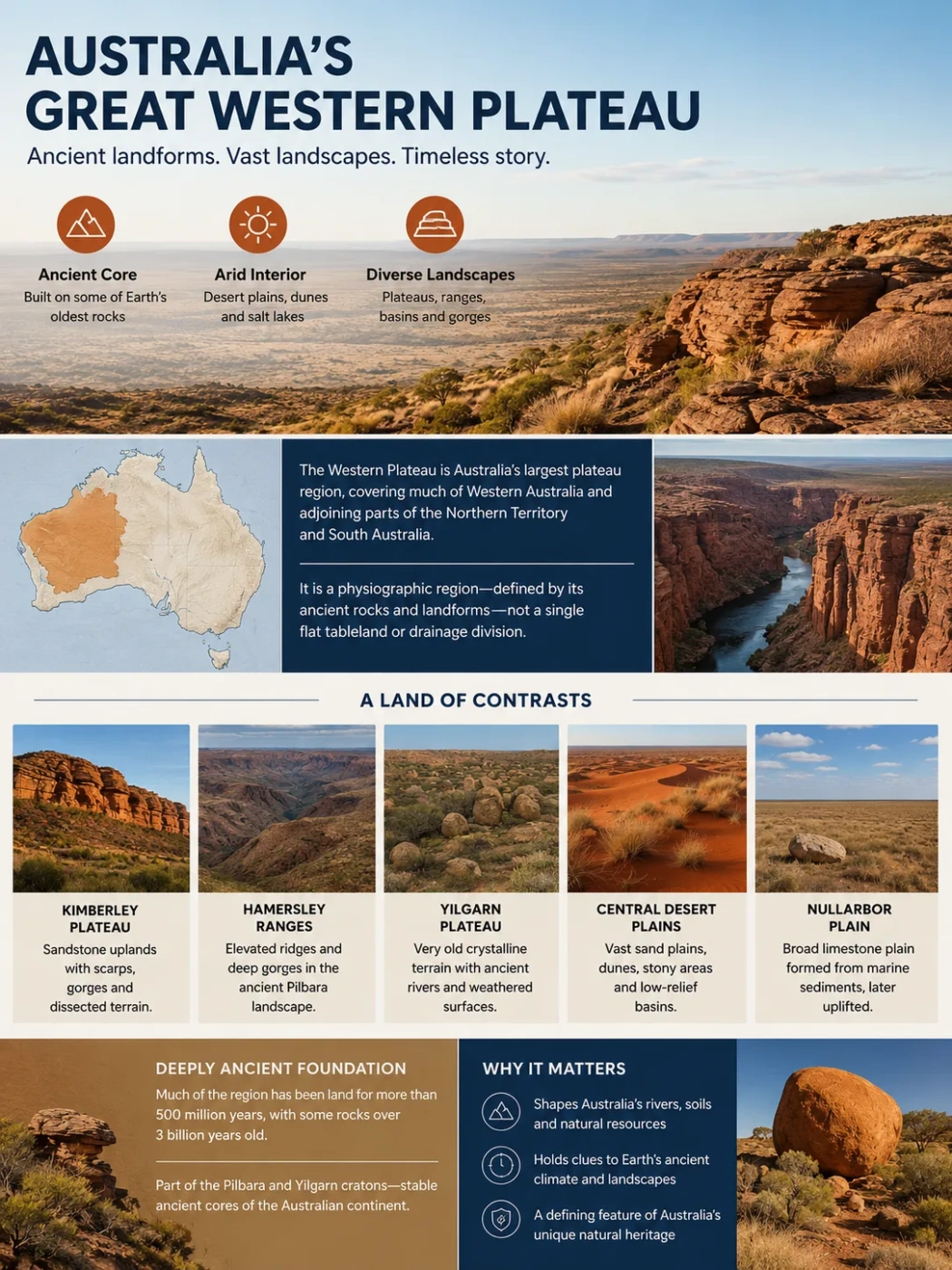
The Western Plateau is the vast, ancient upland division that occupies much of western and central Australia. Despite its name, it is not one continuous flat tableland. It is a broad physiographic region made up of old rock surfaces, desert plains, low plateaus, ranges, basins, dune fields, salt-lake country and isolated resistant landforms.
Mostly arid interior
Plateaus, ranges and desert plains
What the Western Plateau Actually Is
Australian physical geography has traditionally been divided into three very broad units: the Western Plateau, the Central Lowlands and the Eastern Highlands. The Western Plateau is the broadest western unit and covers a large part of Western Australia together with adjoining parts of the Northern Territory and South Australia.
The word plateau can be misleading if it suggests a single elevated surface with one clear rim. The region contains many individual uplands and erosion surfaces rather than one uniform slab. Some areas are gently undulating, some are sandy or stony desert, and others rise into rugged ranges cut by deep gorges.
Terminology Note
The Western Plateau is a physiographic division, meaning a very large region grouped by landform and geological character. It should not be treated as identical to a single modern drainage division. Australian water reporting now uses separate drainage units such as the North Western Plateau and South Western Plateau.
Why It Is Australia’s Largest Plateau Region
The Western Plateau occupies the great western interior of the mainland, making it the largest of Australia’s classic plateau-scale physiographic regions. Its size comes from the underlying geological structure: much of western Australia is built on very old and stable continental crust that has been exposed, weathered and eroded over immense spans of time.
That long history explains the region’s broad, subdued relief. Australia has experienced prolonged erosion rather than the widespread recent mountain building seen on some other continents. As high areas wore down, sediment moved into lower basins and depressions. The result is a landscape where enormous distances may have only moderate changes in elevation, interrupted by ranges, mesas, scarps and isolated rock masses.
A Plateau Made of Several Different Landscapes
There is no single landform that can represent the whole Western Plateau. Individual plateau areas include the Kimberley, Hamersley and Yilgarn. The Nullarbor Plain shows how varied the region can be: unlike the ancient crystalline cratons farther north and west, the Nullarbor is a younger limestone surface formed from marine sediments and later uplifted.
| Landscape | Physical Character | Why It Matters |
|---|---|---|
| Kimberley Plateau | Sandstone-dominated uplands with dissected surfaces, scarps and gorges | Shows that the northern part of the broad plateau region can be rugged rather than flat |
| Hamersley Plateau and Range country | Elevated ridges, plateaus and deeply cut gorges in the Pilbara | Contains some of Western Australia’s highest terrain |
| Yilgarn Plateau | Very old crystalline terrain with deeply weathered surfaces and ancient drainage remnants | Preserves evidence of drainage patterns older than Australia’s separation from Antarctica |
| Central desert plains | Sand plains, longitudinal dunes, stony surfaces and low-relief basins | Form much of the visual character of the dry interior |
| Nullarbor Plain | Broad limestone plain developed on younger marine rocks | Shows that not every part of the Western Plateau is built from ancient exposed shield rock |
The Geological Foundation Is Extremely Old
Much of the Western Plateau has existed as land for more than 500 million years, while some rocks within the western part of the continent are more than 3 billion years old. The region includes parts of the Pilbara and Yilgarn cratons, two ancient blocks of continental crust in Western Australia.
A craton is an old, stable part of a continent that has survived repeated tectonic change. This helps explain why the Western Plateau is dominated by old erosion surfaces rather than long belts of young folded mountains. The landscape visible today is much younger than many of the rocks beneath it, because erosion, weathering and sediment movement have repeatedly reshaped the surface.
The Western Plateau is therefore not simply an exposed piece of one ancient rock shield. Sedimentary basins, younger deposits and uplifted surfaces occur alongside Archean and Proterozoic terrains. The contrast is especially clear between the ancient western cratons and the limestone of the Nullarbor Plain.
Long Erosion Created Broad Surfaces and Isolated High Ground
The plateau’s modern relief reflects millions of years of denudation. Old folds, faults and resistant rock bodies were gradually worn down, while sediments accumulated in lower parts of the interior. Some harder formations remained above the surrounding plain as ranges, ridges or isolated masses.
Central Australia provides a clear example. Uluṟu and Kata Tjuṯa stand above a much lower surrounding surface, but they are not volcanic cones. Uluṟu is made mainly of arkose sandstone, while Kata Tjuṯa is conglomerate. Their prominence is linked to the removal of surrounding material and the resistance and structure of the rocks that remain.
Different rock units provided surfaces with different resistance to weathering and erosion.
High ground was lowered while loosened material moved into basins and depressions.
Broad plains now surround surviving ranges, scarps, mesas and isolated resistant formations.
Aridity Changed the Surface Without Creating the Plateau Itself
The Western Plateau is strongly associated with Australia’s dry interior, but the ancient geological foundation came first. Widespread aridity developed much later in Australia’s landscape history. As the continent became drier, wind action, episodic runoff, salt accumulation and dune formation became more prominent surface processes.
Large areas are now occupied by the Great Sandy, Gibson and Great Victoria desert regions, along with other arid landscapes. These deserts are not simply seas of loose sand. They include sand plains, long dune systems, rocky surfaces, low ridges, claypans, salt lakes and areas with exposed bedrock.
Longitudinal dunes are widespread across the inland arid zone. Many are now stabilised by vegetation, although their form records long periods of wind-driven sand movement. Stony desert surfaces, often called gibber plains, occur where finer material has been removed or redistributed and a cover of stones remains.
Water Often Drains Inward or Disappears Before Reaching the Sea
Drainage is one of the Western Plateau’s most distinctive landscape features. In many inland areas there is too little dependable runoff to maintain large permanent river systems. Channels may remain dry for long periods and then carry water after heavy rain.
Some drainage ends in inland depressions, salt lakes or disconnected channels. Elsewhere, water infiltrates into the ground or is lost through evaporation before it can travel far. This produces a very different drainage pattern from the wetter eastern margin of Australia, where many rivers flow more directly toward the sea.
Ancient drainage can still be read in parts of the landscape. In the Yilgarn region, chains of salt lakes occupy remnants of old drainage systems that developed when Australia was still connected to Antarctica. These systems show that today’s dry, discontinuous drainage is only the latest stage in a much longer geomorphic history.
Drainage and Plateau Boundaries Are Not the Same Thing
Older geography references sometimes use “Western Plateau” for both a landform region and a very broad drainage area. Modern hydrological mapping uses more detailed drainage divisions. A physiographic map and a drainage map therefore will not show identical boundaries.
Elevation Is Moderate Across Much of the Region
The name “plateau” does not mean that most of the region is mountainous. Much of the Western Plateau has moderate elevation and low local relief. Higher ground is concentrated in particular uplands and ranges rather than spread evenly across the region.
The Hamersley Range in Western Australia’s Pilbara is one of the clearest high-relief areas. Mount Meharry, the highest mountain in Western Australia, reaches about 1,253 metres above sea level. Deep gorges cut into the Hamersley country, creating sharp local relief within a much broader plateau setting.
Farther inland, the MacDonnell and Musgrave ranges break the apparent flatness of central Australia. These ranges are remnants of much older tectonic structures that have been repeatedly exposed and reshaped by erosion. Their presence is another reason the Western Plateau should not be pictured as a single flat plain.
The Western Edge Is Not a Simple Plateau Rim
Along parts of Western Australia, younger coastal rocks and lowlands lie beside the much older interior. Near Perth, the Darling Fault and associated escarpment mark a strong geological and topographic transition between the coastal zone and the Yilgarn Craton.
Farther north, the plateau approaches the coast through very different terrain, including Pilbara uplands and dissected river systems. The northern Kimberley has yet another form, with sandstone plateaus cut by gorges and river valleys. Because these margins differ so much, there is no single escarpment that forms a continuous western wall around the entire division.
How the Western Plateau Differs From Australia’s Other Major Divisions
Western Plateau
- Dominated by very old continental crust and long-lived erosion surfaces
- Contains broad arid and semi-arid interiors
- Includes several separate plateaus, desert plains, ranges and internal drainage areas
- Large areas have intermittent surface drainage
Eastern Highlands and Central Lowlands
- Eastern Highlands form the elevated eastern margin and the Great Divide
- Central Lowlands occupy lower country between the western and eastern uplands
- Major eastern and southeastern river systems are tied closely to the Great Dividing Range
- The Central Lowlands include large sedimentary basins and extensive low plains
This three-part view is useful at continental scale, but it is intentionally broad. More detailed geological, geomorphic and hydrological maps divide Australia into many smaller provinces, basins, plateaus, ranges and drainage systems. The Western Plateau is best understood as a continental-scale physiographic region united by old crust, long erosion history and generally subdued relief, not as one uniform landform with a sharp boundary.